PaulW
Ultra Nomad

Posts: 3005
Registered: 5-21-2013
Member Is Offline
|
|
Gulick 1960 - Las Palomas?
Hi Lance
I am far away for my library and maps. but a quick search found the following
All copied from previous Nomad threads.
Regarding Los Polmas both INEGI & Atlas show it clearly at 20 6.65, -114 32.553, and slightly east. INEGI shows Codornices general area with no
specific location. A specific location is found further east called SanJose las Palomas. These locations are on the road we call Condornice road.
The Rancho known as Condornices (ranch not shown on the Almac or the Atlas). And this ranch does not appear on Google earth.
There is a place called “San Antonio” (AB) that some might called “Rancho Condornices” based on Gulick’s 1967 map?
The Almac shows a place called Condornices, but that label is east of the present functional rancho on the road we call Condornices.
Search Nomads for extensive discussion on your subject.
Also search for the great Mural of Condornices where rock art is found. Not near you positions.
Your second cords 29 24 14n, -114 37 13w =29 24.233, -114 37.217 does not show on the Atlas See the image below from Benchmark Atlas. Also, nothing
shows on INEGI.
.jpg - 92kB")
|
|
|
4x4abc
Ultra Nomad
Posts: 4163
Registered: 4-24-2009
Location: La Paz, BCS
Member Is Offline
Mood: happy - always
|
|
the census database of the government has Codornices at 29°11'15.69"N, 114°17'51.46"W. Meaning a real person living there told the gov, this is
Codornices.
Harald Pietschmann
|
|
|
4x4abc
Ultra Nomad
Posts: 4163
Registered: 4-24-2009
Location: La Paz, BCS
Member Is Offline
Mood: happy - always
|
|
again, census data shows San José De Las Palomas at 29° 6'12.44"N, 114°31'30.87"W
Harald Pietschmann
|
|
|
4x4abc
Ultra Nomad
Posts: 4163
Registered: 4-24-2009
Location: La Paz, BCS
Member Is Offline
Mood: happy - always
|
|
Codornices rock art at 29°14'26.84"N, 114°22'46.99"W
and
29°14'0.29"N, 114°24'40.17"W
and half a dozen more in the area
[Edited on 1-31-2022 by 4x4abc]
Harald Pietschmann
|
|
|
PaulW
Ultra Nomad
Posts: 3005
Registered: 5-21-2013
Member Is Offline
|
|
Refer to INEGI and see it as Harald posted. Not shown on Atlas.
Two active ranches along the Condornices road north of the place on the Atlas marked Los Palomas. The first one north is active and large and the
second one a short distance further north. Just a family with animals, house, stables, etc. Further north is San Antonio which 1967 Gulick infers is
Rancho Condornices, Next north on a side road of Condornices road is San Jose de las Palomas.
Further north along the coast is another Los Palomas.
|
|
|
David K
Honored Nomad
Posts: 64480
Registered: 8-30-2002
Location: San Diego County
Member Is Offline
Mood: Have Baja Fever
|
|
Lance the first photos from Howard you linked to are indeed at the Las Palomas, on Gulick's map. It is on the same road that passes what he called
Codornices (and newer maps call San Antonio). Looks exactly like the place where I drove by in 2017.
This place had no ranch I could see from the road I was on and it was a short distance west of La Miseria (where I rescued that couple and others have
too). On the satellite image (at Harald's waypoint) would be the closest thing to the Las Palomas of Gulick.
Maybe utilize some of the 200 maps I have now at VivaBaja.com to help see how names change or not.
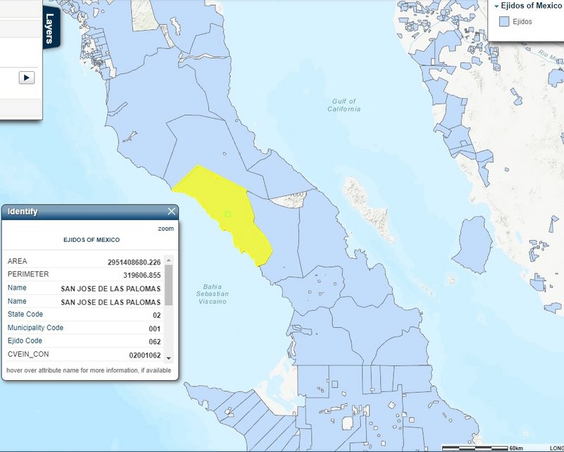
The ejido in this area uses the name San José de las Palomas.
[Edited on 1-30-2022 by David K]
|
|
|
David K
Honored Nomad
Posts: 64480
Registered: 8-30-2002
Location: San Diego County
Member Is Offline
Mood: Have Baja Fever
|
|
Quote: Originally posted by PaulW  | Hi Lance
I am far away for my library and maps. but a quick search found the following
All copied from previous Nomad threads.
Regarding Los Polmas both INEGI & Atlas show it clearly at 20 6.65, -114 32.553, and slightly east. INEGI shows Codornices general area with no
specific location. A specific location is found further east called SanJose las Palomas. These locations are on the road we call Condornice road.
The Rancho known as Condornices (ranch not shown on the Almac or the Atlas). And this ranch does not appear on Google earth.
There is a place called “San Antonio” (AB) that some might called “Rancho Condornices” based on Gulick’s 1967 map?
The Almac shows a place called Condornices, but that label is east of the present functional rancho on the road we call Condornices.
Search Nomads for extensive discussion on your subject.
Also search for the great Mural of Condornices where rock art is found. Not near you positions.
Your second cords 29 24 14n, -114 37 13w =29 24.233, -114 37.217 does not show on the Atlas See the image below from Benchmark Atlas. Also, nothing
shows on INEGI.
|
The Benchmark map does have the same Las Palomas as being discussed: On the Avenza digital baja Atlas: 29°05'42.4"N, 114°32'35.9"W but the map has
it a bit west of the active ranch on the satellite image.
[Edited on 1-30-2022 by David K]
|
|
|
David K
Honored Nomad
Posts: 64480
Registered: 8-30-2002
Location: San Diego County
Member Is Offline
Mood: Have Baja Fever
|
|
| Quote: Originally posted by 4x4abc | the census database of the government has Codornices at 29°11'15.69"N, 114°17'51.46"W. Meaning a real person living there told the gov, this is
Codornices.
|
In 2017, this ranch looked 'semi-abandoned'... but 'new' compared to the original Codornices (San Antonio) just west of it which is 100+ years old.
|
|
|
David K
Honored Nomad
Posts: 64480
Registered: 8-30-2002
Location: San Diego County
Member Is Offline
Mood: Have Baja Fever
|
|
| Quote: Originally posted by Lance S. | To clear things up regarding Codornices-
The water source located here 29°11'44"N 114°19'01"W is the original Codornices. At some point a ranch called San Antonio was built there.
The old Rancho San Antonio is located at Codornices. |
Exactly correct!
Codornices (at that location) appears on the Maps of 1918, 1922, 1928, 1956-1962.
San Antonio appears on the AAA maps of 1997+
San Antonio (Codornices) together like that, appears on the Mexican topos and Baja Almanac maps.
See all these maps and more: https://vivabaja.com/maps/
|
|
|
PaulW
Ultra Nomad
Posts: 3005
Registered: 5-21-2013
Member Is Offline
|
|
David is correct -- Meanwhile
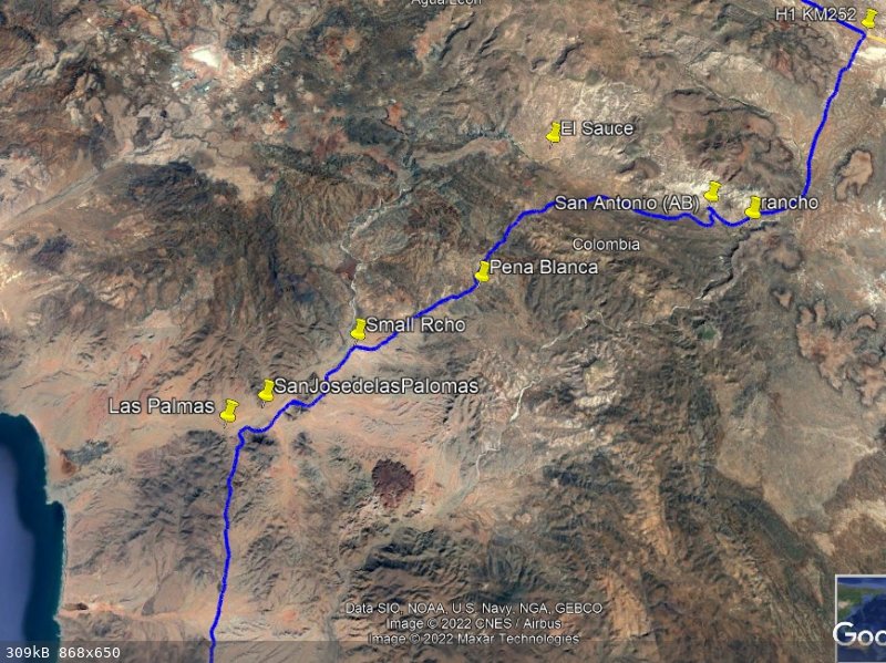
Reviewing the geography along Codarnices road
Places along the Codarnices road with GE coordinates Codarnices
All shown on Cal Topo except as noted.
Las Palomas 29 5.670 -114 32.57 Not visited
San Jose de Las Palomas 29 6.207, -114 31.576 Much activity. Gated and fenced
Small Rancho 29 7.822, -114 29.164 3 persons and a few cattle. Not shown on Cal Topo
Pena Blanca 29 9.415, -114 25.715 Not visited.
San Antonio (AB) also mapped as Rancho Codarnices 29 11.797, -114 19.029 Ruins and big hole.
El Sauce 29 13.385, -114 23.675 Not shown on GE. Not visited.
Rancho 29 11.276, -114 17.849 Not visited. Not shown on Cal Topo
I went to H11D48 1974 and found Cementerio Codarnices
I went to H11D49 1974 and found San Antonio (Codarnices)
I went to H11D49 1974 and found San Antonio (Codarnices)
I went to H11D49 2019 and found Cementerio gone and found a new location for Las Palomas.
And Added Rancho Codarnices at the place I called Rancho above
Then I found several more buildings located along the Codarnices road.
My conclusion is INEGI is doing real updates and Cap topo does not reflect the changes.
Looking at Google Earth at San Antonio is an image from 2005. When I was there a year ago there was a lot of trees and no visible surface water.
[Edited on 1-30-2022 by PaulW]
|
|
|
David K
Honored Nomad
Posts: 64480
Registered: 8-30-2002
Location: San Diego County
Member Is Offline
Mood: Have Baja Fever
|
|
Isn't that a great map? Wasn't easy to scan!
|
|
|


