| Pages:
1
2
3 |
PaulW
Ultra Nomad

Posts: 3009
Registered: 5-21-2013
Member Is Offline
|
|
Pole Line + Mano - March 2022
Pole Line and Mano 3/9-10/2022
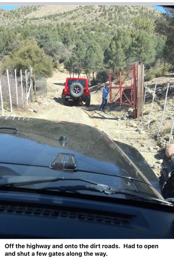
Started form San Felipe North to Hwy 3 west on Hwy3 to Km 78.6
Good road with go arounds for the mud puddles
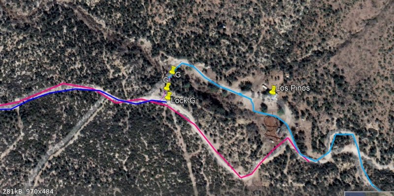
Thru gate at Los Pinos now locked permanently. Opened the two gates into the Los Pinos compound and spoke with a guy. He asked where we were going,
and I told him Mano and he shrugged and walked away.
The next gate a a rancho further has removed a corral fence and gate, but still had a gate which was open across the main in track. The rancher is
building a new ranch house and is apparently living in a motor home. Nobody was seen.
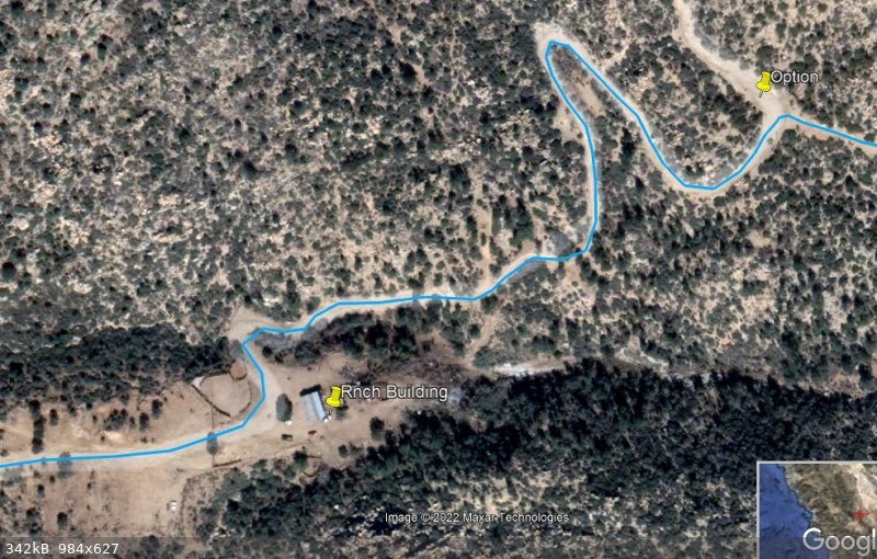
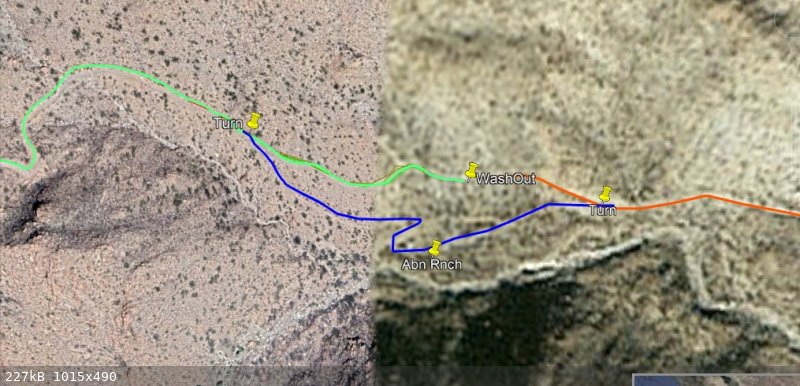
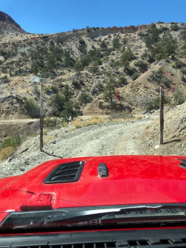
Further heading east we came to a n active mine and the normal road had a new gate which was not locked. Two padlocks and the chain on the ground.
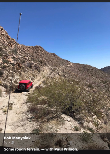
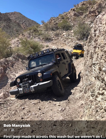
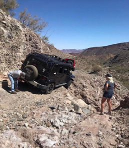
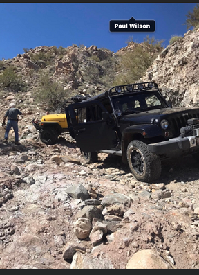
Next, we found a washed-out place on the shelf road. Fortunately, we could see an abandoned ranch way below us and after a difficult turn around we
used that ranch road to continue to Mano Junction.
Now days we travel south bound up Arroyo En Medio and found it full of vegetation, so we had to pick our way up the drainage. The turn east out of
the wash had to be improvised and the bank was taller that it was two years ago. The rest of the Pole Line Road was in very good shape, and we
traveled it slowly in the difficult places Nothing to report on “basketball hill” and the so called “Bad hill” was not a problem even for a
stock Jeep on 31” tires.
We took the path across Arroyo Grande to Hwy5 at Km135
The trip was the fasted Pole Lin Road so far even with the task for winching out the grey Jeep and turning around at the Wash-out. Mostly due to the
easy approach from Hwy3.
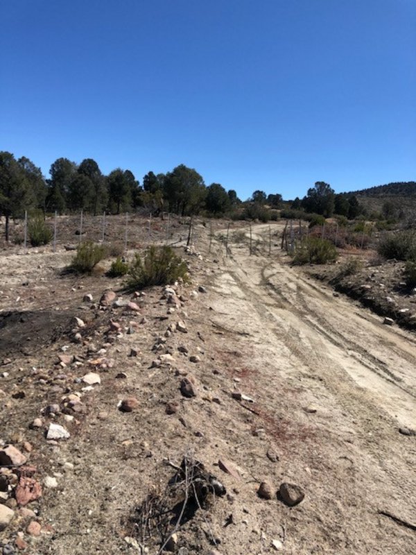
Along the road
Look for the turns at 31 49.273, -115 40.808 & 3149 233, -115 40.513
Pics coming
|
|
|
PaulW
Ultra Nomad
Posts: 3009
Registered: 5-21-2013
Member Is Offline
|
|
Entering the los Pinos Compound

 2.99 breakfast 2.99 breakfast

Main Road Locked gate
Ranch with motor home
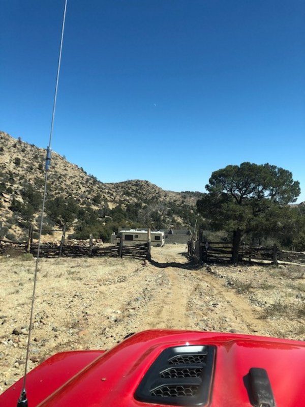
New gate
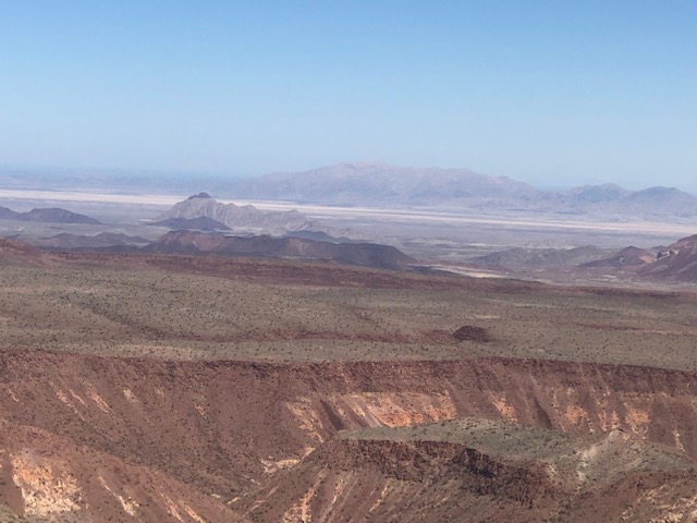
The view from Mano. Near the summit

|
|
|
John Harper
Super Nomad
Posts: 2289
Registered: 3-9-2017
Location: SoCal
Member Is Offline
|
|
Wow, that's really cool. Thank you for posting. I love dirt roads and exploring. I'm not a 4 wheeler, but I certainly admire your skills.
I've been debating driving to Mike's in a couple weeks due to lack of rain this year for trout fishing. But, just driving 40 miles of dirt may be
worth it just for the ride. I've driven hundreds of miles FS roads in Wyoming and I love it.
John
[Edited on 3-22-2022 by John Harper]
|
|
|
David K
Honored Nomad
Posts: 64490
Registered: 8-30-2002
Location: San Diego County
Member Is Offline
Mood: Have Baja Fever
|
|
Thanks for this!
Oh boy... what fun... Too bad so many gates.
So, at the locked gate, you simply entered the ranch's 'front yard' and continued to where you rejoined the Mano Grade road again?
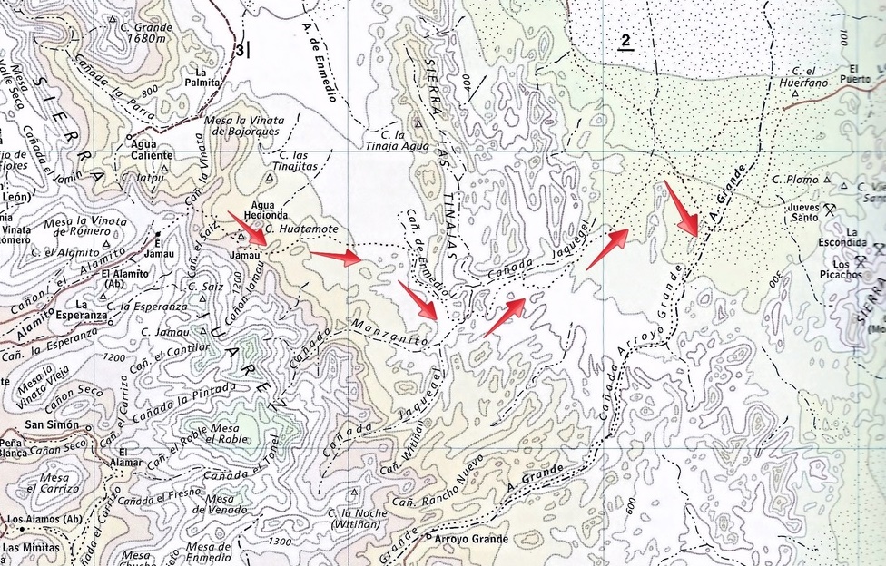
"Now days we travel south bound up Arroyo En Medio and found it full of vegetation, so we had to pick our way up the drainage. The
turn east out of the wash had to be improvised and the bank was taller that it was two years ago. "
I presume this is what the topo maps show as Cañon El Sáiz, where our group camped on Night 1, in 2015 (just south of the bottom of the Summit road,
left of the first red arrow)?
|
|
|
4x4abc
Ultra Nomad
Posts: 4166
Registered: 4-24-2009
Location: La Paz, BCS
Member Is Offline
Mood: happy - always
|
|
do you have track that you could share, Paul?
Harald Pietschmann
|
|
|
PaulW
Ultra Nomad
Posts: 3009
Registered: 5-21-2013
Member Is Offline
|
|
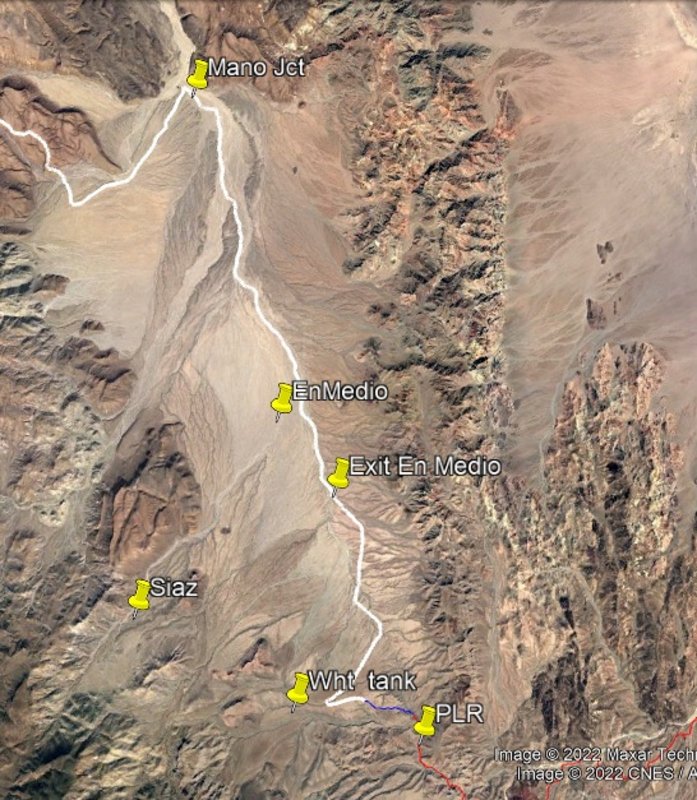
en Medio area and track
|
|
|
PaulW
Ultra Nomad
Posts: 3009
Registered: 5-21-2013
Member Is Offline
|
|
Mano + PLR Track
Part 1 Hwy3 Km78.6 to Mano Junction
Attachment: M+PLRK58-M Jct.gpx (147kB)
This file has been downloaded 143 times
[Edited on 3-22-2022 by PaulW]
|
|
|
PaulW
Ultra Nomad
Posts: 3009
Registered: 5-21-2013
Member Is Offline
|
|
Part 2 Mano Jct to Hwy 5
Attachment: Mjct-Hwy5 M+PLR.gpx (307kB)
This file has been downloaded 137 times
|
|
|
PaulW
Ultra Nomad
Posts: 3009
Registered: 5-21-2013
Member Is Offline
|
|
Gates
Probably driving thru the front yard of Los Pinos won last very long.
There is a go around for Los Pinos and the motorhome ranch gates should it be necessary.
The track not driven by me begins west of Los Pinos and heads up hill and loops back just east of the Ranch with the motorhome.
I have an old report by a SF guy that said it was drivable when all the gates were locked. That loop road, at the both intersections, of the Mano
track look well used. It is quite visible on Google Earth which means one could make a GPS track. If you want to do Mano it would be a good plan to
make a track for the loop.
|
|
|
PaulW
Ultra Nomad
Posts: 3009
Registered: 5-21-2013
Member Is Offline
|
|
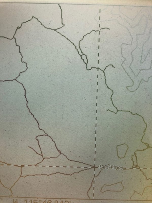
The los Pinos bypass loop
|
|
|
David K
Honored Nomad
Posts: 64490
Registered: 8-30-2002
Location: San Diego County
Member Is Offline
Mood: Have Baja Fever
|
|
Ahhh... so you totally avoided the Saiz area near the bottom of the Summit and did the White Tank access road! Got it.
Too bad we lose so much of the 1942 road drive between the summit grade and the White Tank.
|
|
|
PaulW
Ultra Nomad
Posts: 3009
Registered: 5-21-2013
Member Is Offline
|
|
Best guess of the original PLR
David is correct a large segment is no longer passable west of White Tank. However the really historic path remains for the adventurer.
Heading from east to west is more difficult than going from west to east due to the climbs up those famous rocky wash-outs. However this year it
should be good.
Back in the day 2005, & 2015 I made tracks for the whole thing.
My best estimate for the path was from near Valley Trinidad to Chinero at Hwy 5.
Shown in 3 parts to allow a bit of detail.
There were several attempts to go around the lock gate at the A Siaz crossing and finally we all gave up. Anyway with the closure of the race summit
there is no reason to deal with that locked gate.
The newer Locked gate west of the race summit cannot be bypassed.
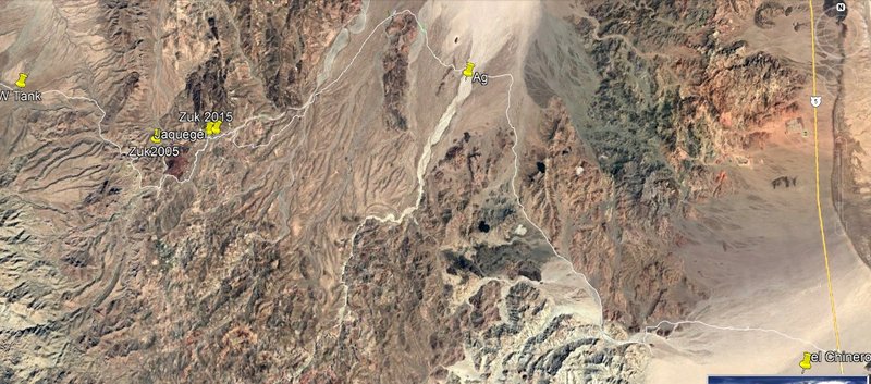
The result is from east of White tank the PLR remains for travelers with the use of A En Medio to the north.
The track for Arroyo Grande to Chinero is used by racers and is slow for most folks.
As of now the road from the mine wells to La Ventana is damaged by flooding making that path to the east an issue.
Hwy 3 K103 to Saiz
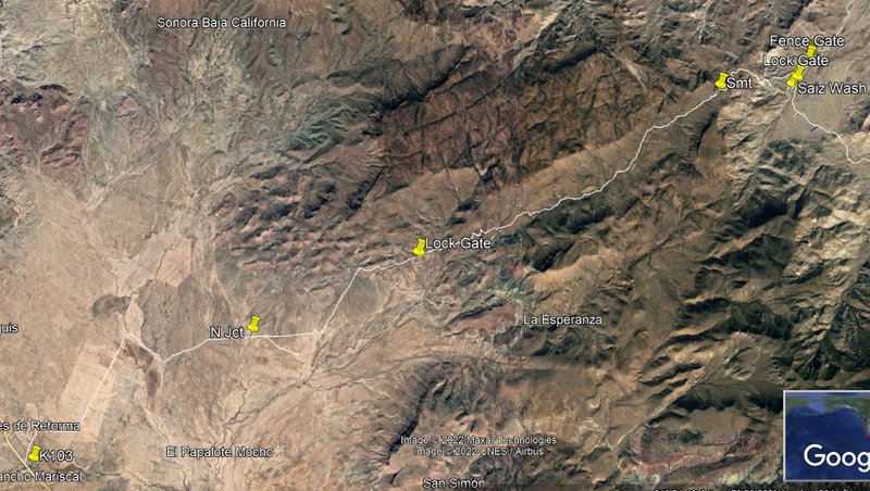
A Saiz to White Tank
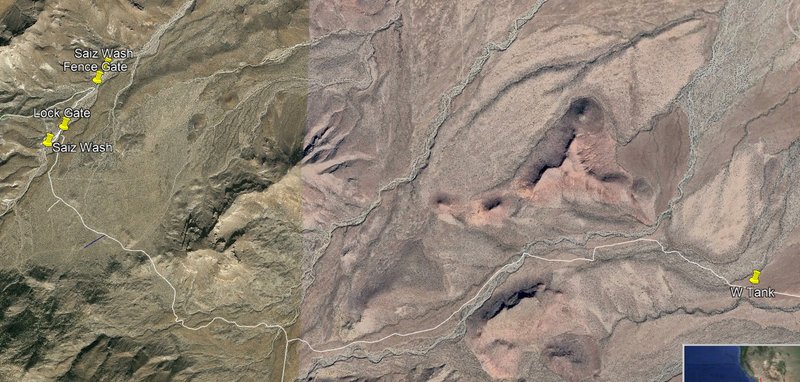
White Tank to Hwy 5
 terminator 2 wallpaper terminator 2 wallpaper
|
|
|
David K
Honored Nomad
Posts: 64490
Registered: 8-30-2002
Location: San Diego County
Member Is Offline
Mood: Have Baja Fever
|
|
It was sure an interesting choice of routes for a telephone line, in 1942.
In my Baja Bound article, I had theorized that might have been to evade Japanese spotter planes who would look at the logical route (ie. via Valle
Trinidad and San Matias Pass)???
https://www.bajabound.com/bajaadventures/bajatravel/pole_lin...
|
|
|
PaulW
Ultra Nomad
Posts: 3009
Registered: 5-21-2013
Member Is Offline
|
|
I wonder what the status was for an easier route like Hwy 3 in 1942?
I do know the canyon from Matias to L Diablo was a difficult canyon before the road was built.
Maybe no one want to travel that direction, but to go over a mountain pass seems an unlikely route unless the locals had been using the pole line
route before 1942.
|
|
|
David K
Honored Nomad
Posts: 64490
Registered: 8-30-2002
Location: San Diego County
Member Is Offline
Mood: Have Baja Fever
|
|
There is history of the route the Pole Line Road took over the summit.
That high pass was called Portezuelo de Jamau. Mission Santa Catalina was established near it as it was considered the route to the Colorado River
(from Mission San Vicente). In other words, an Indian route even before the Spanish came. The missionaries were seeking a land route to Sonora for
almost their entire time in Baja.
See also page 97 of the 1962-1970 editions of the Lower California Guidebook.
Mex #3 is a newer name for the highway that began as BC #16. That highway was built and paved in the 1970s, completed in 1978. The dirt road before
was developed on the route of a wagon road. The San Matias Pass was the only natural route for wagons and vehicles. I had ridden on it as a kid in
'67, and driven it later in the mid-70s, before the highway was built on the east half. Even after the highway, SCORE used the older auto route on the
floor of the canyon (sandy arroyo).
The last time I drove from San Matias Pass to Diablo Dry Lake (and on to San Felipe) on the original Ensenada-San Felipe road was in 1979, pre-running
for that year's 1000.
|
|
|
4x4abc
Ultra Nomad
Posts: 4166
Registered: 4-24-2009
Location: La Paz, BCS
Member Is Offline
Mood: happy - always
|
|
this 1919 map is a good indication of what was used
we have so many old maps now - let's use them

Harald Pietschmann
|
|
|
4x4abc
Ultra Nomad
Posts: 4166
Registered: 4-24-2009
Location: La Paz, BCS
Member Is Offline
Mood: happy - always
|
|
1937
looks like the trail east went through Agua Caliente

Harald Pietschmann
|
|
|
PaulW
Ultra Nomad
Posts: 3009
Registered: 5-21-2013
Member Is Offline
|
|
Before racing and rancher fences the route over Portezuelo de Jamau was probably an easy drive up the valley for 1940 vintage trucks.
Of course Racing and fencing had minor changes compared to the hurricanes that rearranged the whole route, mostly on the N or E side.
I was thinking about how En Medio and Jaquegel would be like before hurricanes. Now there are 50' waterfall cliffs present.
Clues appear that the Indians had a desire for a direct route NE
But there was rancher activity on the other side of the mountain pass.
What is time frame that poly pipe arrived.
I wonder about the age of the white tank and poly pipe on the pipe road
|
|
|
David K
Honored Nomad
Posts: 64490
Registered: 8-30-2002
Location: San Diego County
Member Is Offline
Mood: Have Baja Fever
|
|
Plenty of interesting maps of that area!
Here are several: https://vivabaja.com/maps/
What "poly pipe" are you asking about...? For the gold mine on Hwy. 5?
|
|
|
PaulW
Ultra Nomad
Posts: 3009
Registered: 5-21-2013
Member Is Offline
|
|
Pole line pipe from White tank north
When did poly pipe start to be used?
|
|
|
| Pages:
1
2
3 |


