| Pages:
1
2
3 |
PaulW
Ultra Nomad

Posts: 3009
Registered: 5-21-2013
Member Is Offline
|
|
From Davids map collection
The road from Valley Trinidad to San Felipe existed in 1884
The eastern part of Buck canyon (1930) is close to the Pole line route. The west end of the Buck canyon noted as Jaquegel and El Tule. It was probably
just a trail back then.
|
|
|
David K
Honored Nomad
Posts: 64488
Registered: 8-30-2002
Location: San Diego County
Member Is Offline
Mood: Have Baja Fever
|
|
Ah yes, thanks for clarifying. I have not been on that road or knew of the pipe. I recall Neal Johns (RIP) talking about that route. He had hand drawn
map notes with mileages and GPS from the late 1990s or early 2000s (on the Baja Almanac map).
If I can find it, I will edit and add!
Eureka!
Not his actual writing, but my copying what was on his 1997 Baja Almanac Norte.
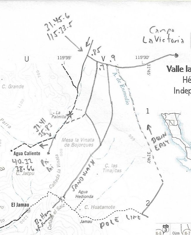
Here are what the penciled-in notes say:
GPS; mileages; 'PaiPai' village; The GPS for Agua Caliente and the fork is missing the 31° and 115° figures; 'sand wash' to the 'bottom of the
summit'; 'Pole Line'; and 'Down Easy' from the white tank. Neal went to 'Campo La Victoria' ruins (featured on older AAA maps).
[Edited on 3-24-2022 by David K]
|
|
|
4x4abc
Ultra Nomad
Posts: 4165
Registered: 4-24-2009
Location: La Paz, BCS
Member Is Offline
Mood: happy - always
|
|
my very first trip on the Pole Line Road was in 1986 - pipe and tank were already there
and they were dry and abandoned at that time too
source for the water was/is Jamau Cattle Camp
the water line parallels PLR for some time after Jamau
then a separate dozer track on higher grounds leads to the tank
the water line continues for a while east of the holding tank
I traced it when Google Earth still had older images up
now it is hard to find

Harald Pietschmann
|
|
|
David K
Honored Nomad
Posts: 64488
Registered: 8-30-2002
Location: San Diego County
Member Is Offline
Mood: Have Baja Fever
|
|
Blue line is?
Yellow lines are?
Thanks!
I also added in Neal Johns' notes I found, above in my reply.
|
|
|
4x4abc
Ultra Nomad
Posts: 4165
Registered: 4-24-2009
Location: La Paz, BCS
Member Is Offline
Mood: happy - always
|
|
blue - water line
yellow - road or dozer track
Harald Pietschmann
|
|
|
PaulW
Ultra Nomad
Posts: 3009
Registered: 5-21-2013
Member Is Offline
|
|
Thanks Harald
I did not know about the water line
|
|
|
4x4abc
Ultra Nomad
Posts: 4165
Registered: 4-24-2009
Location: La Paz, BCS
Member Is Offline
Mood: happy - always
|
|
I found it!
found the old trail between Santa Catarina and Agua Caliente (continuing to Rio Hardy)
31°39'34.54"N, 115°39'12.95"W
very distinct trail

[Edited on 3-25-2022 by 4x4abc]
Harald Pietschmann
|
|
|
bajatrailrider
Super Nomad
Posts: 2423
Registered: 1-24-2015
Location: Mexico
Member Is Offline
Mood: Happy
|
|
cool picture ABC can we drive it with 4 wheels
|
|
|
ehall
Super Nomad
Posts: 1906
Registered: 3-29-2014
Location: Buckeye, Az
Member Is Offline
Mood: It's 5 o'clock somewhere
|
|
Paul. Where all our motorcycle tracks still there? We went thru the vegetation in the wash then all the way south to the summit and went up. Locked
gate at top with a moto trail around it.
|
|
|
4x4abc
Ultra Nomad
Posts: 4165
Registered: 4-24-2009
Location: La Paz, BCS
Member Is Offline
Mood: happy - always
|
|
don't think so - bike should work though
Harald Pietschmann
|
|
|
4x4abc
Ultra Nomad
Posts: 4165
Registered: 4-24-2009
Location: La Paz, BCS
Member Is Offline
Mood: happy - always
|
|
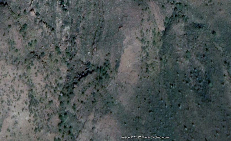
found another important cross mountain trail - La Vinata
31.649353, -115.603633
best here:
https://satellites.pro/mapa_de_Mexico#31.649353,-115.603633,...
Harald Pietschmann
|
|
|
mtgoat666
Select Nomad
Posts: 17332
Registered: 9-16-2006
Location: San Diego
Member Is Offline
Mood: Hot n spicy
|
|
Me thinks you are finding cattle trails. Cattle are like food-motivated-robots that make trails to food or water sources.
Woke!
“...ask not what your country can do for you – ask what you can do for your country.” “My fellow citizens of the world: ask not what America
will do for you, but what together we can do for the freedom of man.”
Prefered gender pronoun: the royal we
|
|
|
4x4abc
Ultra Nomad
Posts: 4165
Registered: 4-24-2009
Location: La Paz, BCS
Member Is Offline
Mood: happy - always
|
|
Quote: Originally posted by mtgoat666  |
Me thinks you are finding cattle trails. Cattle are like food-motivated-robots that make trails to food or water sources. |
how do you think the first humans found their way around?
they followed animal trails
and when the Jesuits showed up - they followed the Indian trails
many of the early roads do the same thing - they followed the Jesuit trails
and it works the other way around as well
the trails/roads abandoned by humans are now used by animals
I use that as an important tool when old roads are overgrown beyond recognition - I look for animal trails
and bingo - back on track
here is one of those situations
animal tracks helped us a couple of times to follow the old road
https://carlosnpainter.smugmug.com/Events/La-Fortuna/
[Edited on 3-26-2022 by 4x4abc]

Harald Pietschmann
|
|
|
PaulW
Ultra Nomad
Posts: 3009
Registered: 5-21-2013
Member Is Offline
|
|
| Quote: Originally posted by ehall | | Paul. Where all our motorcycle tracks still there? We went thru the vegetation in the wash then all the way south to the summit and went up. Locked
gate at top with a moto trail around it. |
Hi Ed,
I have not been up that summit track for several years. Do you mean the gate heading down from the summit with the big 4" pipe?
If you took the track up Saiz then we would not see your tracks because we went up En Medio. I am surprised you got the bikes around the summit Gate
from my memory?
|
|
|
PaulW
Ultra Nomad
Posts: 3009
Registered: 5-21-2013
Member Is Offline
|
|
Trails
Cattle trail
Leaving Parral and taking the hike toward Matomi ranch I headed out with no trail to follow. Started out following the gully then went astray heading
to my right. It was difficult and lots of cactus. I got to the saddle and turned around and found the cattle trail much easier. That trail is barely
visible on Google Earth. BTW, the cattle trail is a huge time saver.
Here are some screen shots

Coords:
Saddle 30 28.559, -115 6.473, Parral Abandoned building 30 29.410, -115 6.988
|
|
|
bajatrailrider
Super Nomad
Posts: 2423
Registered: 1-24-2015
Location: Mexico
Member Is Offline
Mood: Happy
|
|
most all cow trails great for dirt bikes half of mine are just that.
|
|
|
ehall
Super Nomad
Posts: 1906
Registered: 3-29-2014
Location: Buckeye, Az
Member Is Offline
Mood: It's 5 o'clock somewhere
|
|
| Quote: Originally posted by PaulW | | Quote: Originally posted by ehall | | Paul. Where all our motorcycle tracks still there? We went thru the vegetation in the wash then all the way south to the summit and went up. Locked
gate at top with a moto trail around it. |
Hi Ed,
I have not been up that summit track for several years. Do you mean the gate heading down from the summit with the big 4" pipe?
If you took the track up Saiz then we would not see your tracks because we went up En Medio. I am surprised you got the bikes around the summit Gate
from my memory? |
Yes. the pipe gate at the top was closed. The trail around it was well used by bikes.
|
|
|
PaulW
Ultra Nomad
Posts: 3009
Registered: 5-21-2013
Member Is Offline
|
|
Planning on another rtip this year
Reflecting of the March 2022 trip
So when Score raced over Mano the permanently locked gate was unlocked and used and the result was they did not drive thru the El Pinos front yard.
Next trip over Mano summit I will use the bypass that avoids both Los Pinos and the next ranch we had to drive thru. The bypass shows clearly on
Google earth. A good exploration trip.
SCORE knew about the sketchy shelf road and routed the track down the valley past the abandoned farm like we had to do. When we went past that shelf
road it was long before SCORE did any marking.
Regarding Saiz. The path is deep sand and Enmedio is easier especially since Enmedio is not gated. For four wheeled rigs access between Saiz and the
pole line is no longer an option due to the gate at Saiz exit.
Thanks to Harald’s for his 1919 map. Several of us searched for months looking for the historical arroyo called El Tule now has the modern name
Jaquegel.
|
|
|
bajatrailrider
Super Nomad
Posts: 2423
Registered: 1-24-2015
Location: Mexico
Member Is Offline
Mood: Happy
|
|
Time flies me and Mike w you guys pole line run 2015. the place we camped before locked gate. Do you still pass that route me and Mike still have same
trucks his red 04 Tacoma . My 2014 Nissan turbo diesel its only on 35,000 miles . Im ready to sell it order 23 hilux diesel.
|
|
|
David K
Honored Nomad
Posts: 64488
Registered: 8-30-2002
Location: San Diego County
Member Is Offline
Mood: Have Baja Fever
|
|
Paul wasn't on that trip, Larry, but he did the scouting work before we got there, as I recall.
We camped just past the steel locked gate, across Arroyo El Saiz from the bottom of the original Summit Grade, up in Arroyo El Saiz just past that
gate blocking the 1942 road to the east.
From our camp we drove a bit south then climbed out of the arroyo to meet the newer road going up the mountain, and took that down to catch the 1942
road heading east.
On my first map, a close up topo map, the dotted route from the locked gate is the detour we used. Mileages shown are for then route, between the
arrows:
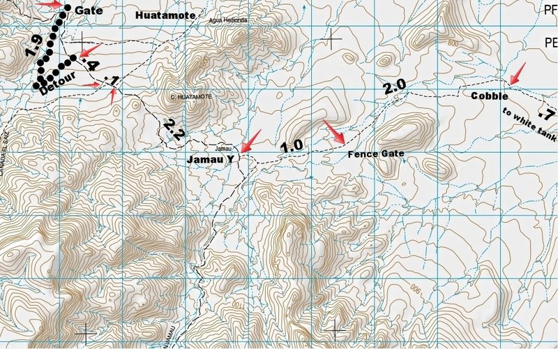
Edit: the 2.2 probably should be 1.7, as shown on the second map.
This is the full Pole Line Road we drove on the Almanac map, noted:
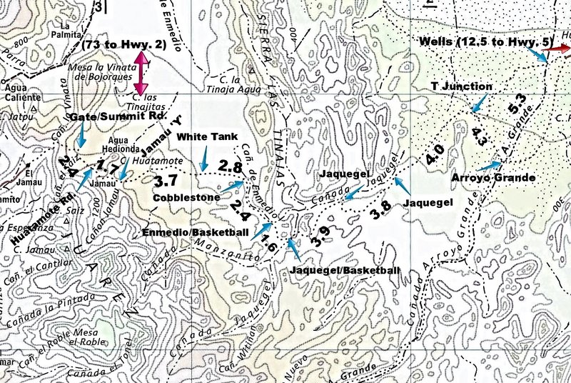
As you may recall, Ken insisted on going left at the T Junction, while my little group went right, as we were going to look in Arroyo Grande for
Melchior Diaz' Grave. That left road was washed out and you had to turn around, pulling that dead Ford Bronco, and come out to the highway by La
Ventana.

Here are the 2015 Pole Line Road Trip Photos: https://vivabaja.com/pole-line-road-2015/
Here is my Baja Bound article: https://www.bajabound.com/bajaadventures/bajatravel/pole_lin...
[Edited on 1-4-2023 by David K]
|
|
|
| Pages:
1
2
3 |


