| Pages:
1
2 |
PaulW
Ultra Nomad

Posts: 3009
Registered: 5-21-2013
Member Is Offline
|
|
Rancho Parral
Posting some pictures with the knowledge then very few of any off roaders will ever get to the place. This is due to a very difficult arroyo crossing.
Yes, I got across and back, but I had to stack rocks differently going each way. Both front and rear lockers and 4 low was needed. Took me 45 minutes
each way for the crossing.
The Parral compound is surrounded by a significant wall. The wall is 5+ feet high, with concrete 2’ wide top, and a base about 4’ across. Some of
the lower rocks are huge and would require equipment to move around. See the yellow lines where the wall is located.
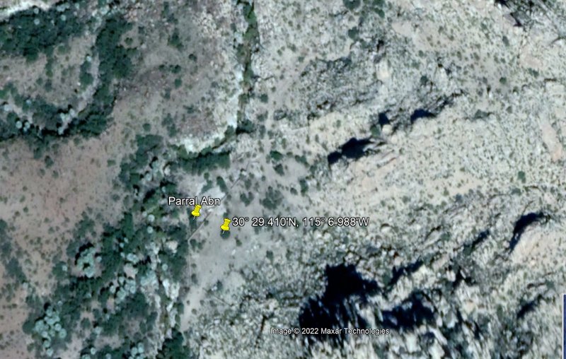
See the walls in Yellow with Road
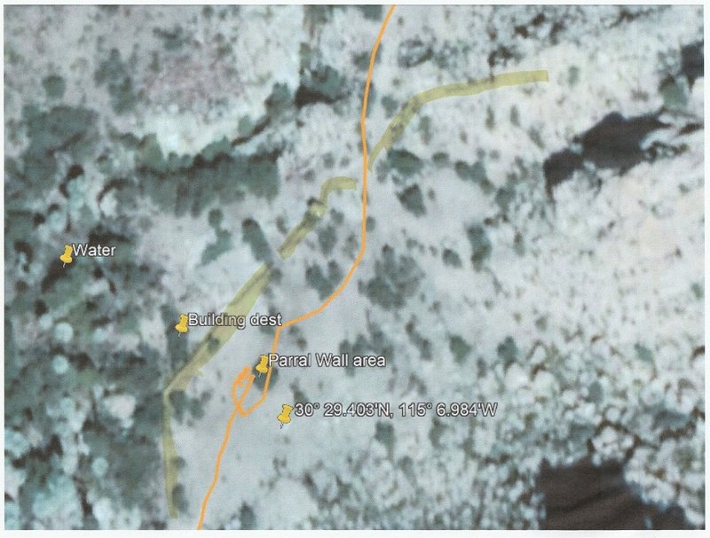
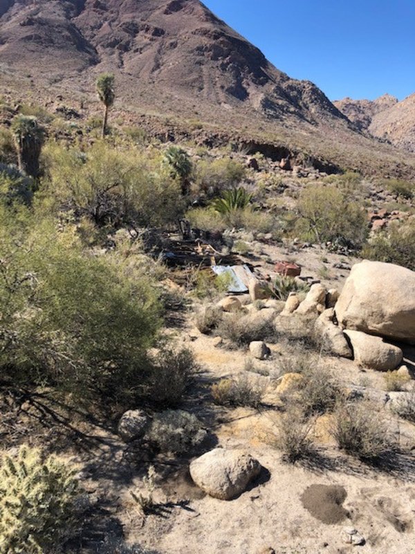
Behind the wall to the N is the ruins of a building and other debris. Water source is nearby.
 
Along the road
     
|
|
|
PaulW
Ultra Nomad
Posts: 3009
Registered: 5-21-2013
Member Is Offline
|
|
Rancho Parral
More along the road

Rocks at the gully crossing
 
Attachment: Paral HikeLOR.gpx (279kB)
This file has been downloaded 103 times


[Edited on 3-28-2022 by PaulW]
|
|
|
bajatrailrider
Super Nomad
Posts: 2423
Registered: 1-24-2015
Location: Mexico
Member Is Offline
Mood: Happy
|
|
Great pictures looks like you had good time
|
|
|
mtgoat666
Select Nomad
Posts: 17335
Registered: 9-16-2006
Location: San Diego
Member Is Offline
Mood: Hot n spicy
|
|
Quote: Originally posted by PaulW  | | Posting some pictures with the knowledge then very few of any off roaders will ever get to the place. This is due to a very difficult arroyo crossing.
|
Looking at you map, it would have been faster to walk than spend 45 min each way driving across hard spot.
Also, walking is much less destructive than driving off established, maintained roads.
Woke!
“...ask not what your country can do for you – ask what you can do for your country.” “My fellow citizens of the world: ask not what America
will do for you, but what together we can do for the freedom of man.”
Prefered gender pronoun: the royal we
|
|
|
4x4abc
Ultra Nomad
Posts: 4165
Registered: 4-24-2009
Location: La Paz, BCS
Member Is Offline
Mood: happy - always
|
|
cool trip - i always wanted to go
the wall is best on the 2009 images
where is the gate?

Harald Pietschmann
|
|
|
David K
Honored Nomad
Posts: 64490
Registered: 8-30-2002
Location: San Diego County
Member Is Offline
Mood: Have Baja Fever
|
|
2004 trip to Rancho El Parral

From our camp in the corral, the road can be driven 0.6 mi. to a major washout where the hike begins. Almost a mile up the trail this was the view.

The view back east, down Parral’s arroyo and on to Valle Chico.
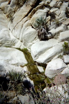
Water flow increased as we neared the site of Rancho El Parral.

Several hundred feet of rock wall enclosed the coral area above the ranch.
RANCHO EL PARRAL 30° 29.43′, -115° 07.02′
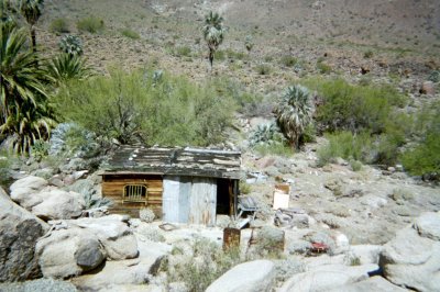
Named for the grapevines (parral) growing just up stream, the ranch is abandoned. Perhaps the flash flood that wiped out the road, a mile away is why
this beautiful location at 2,901′ is unoccupied?
BEHIND THE RANCH…

…was this beautiful scene.

A granite pinnacle and more rock walls are southeast of the ranch.
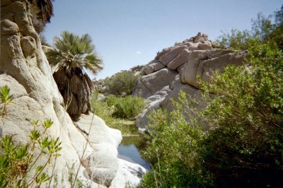
Going downstream, along the creek, is a different route back.
[Edited on 3-28-2022 by David K]
|
|
|
PaulW
Ultra Nomad
Posts: 3009
Registered: 5-21-2013
Member Is Offline
|
|
Blueroadrunner is back, alive with lots of archived content. Some what difficult to date many of the links.
Here is the Parral link many of us remember written by Lou Wells
http://www.blueroadrunner.com/Writing/parral.htm
I think it was the 2004 trip?
Shows some changes with the Parral building and some pictures I left out
Edit
Blueroadrunner is now dead forever
[Edited on 4-11-2024 by PaulW]
|
|
|
David K
Honored Nomad
Posts: 64490
Registered: 8-30-2002
Location: San Diego County
Member Is Offline
Mood: Have Baja Fever
|
|
Very cool! The same trip when I took the photos above.
When I return from Mission Santa María, I will add that link to VivaBaja.com.
Thanks Paul!
|
|
|
PaulW
Ultra Nomad
Posts: 3009
Registered: 5-21-2013
Member Is Offline
|
|
Lots of dead links in Blueroadrunner
|
|
|
PaulW
Ultra Nomad
Posts: 3009
Registered: 5-21-2013
Member Is Offline
|
|
Harald
where is the gate?
30 30.99, -115 6.27
|
|
|
bajatrailrider
Super Nomad
Posts: 2423
Registered: 1-24-2015
Location: Mexico
Member Is Offline
Mood: Happy
|
|
 | Quote: Originally posted by mtgoat666 | | Quote: Originally posted by PaulW | | Posting some pictures with the knowledge then very few of any off roaders will ever get to the place. This is due to a very difficult arroyo crossing.
|
Looking at you map, it would have been faster to walk than spend 45 min each way driving across hard spot.
Also, walking is much less destructive than driving off established, maintained roads.
|
your nobody to
tell people to walk when they want to off road . Are you a idiot yes you are 
|
|
|
4x4abc
Ultra Nomad
Posts: 4165
Registered: 4-24-2009
Location: La Paz, BCS
Member Is Offline
Mood: happy - always
|
|
nock locked, I take it?
Harald Pietschmann
|
|
|
PaulW
Ultra Nomad
Posts: 3009
Registered: 5-21-2013
Member Is Offline
|
|
=== =
Yes, not locked Very heavy - bottom buried in the sand.
|
|
|
PaulW
Ultra Nomad
Posts: 3009
Registered: 5-21-2013
Member Is Offline
|
|
| Quote: Originally posted by David K |
From our camp in the corral, the road can be driven 0.6 mi. to a major washout where the hike begins. Almost a mile up the trail this was the view.
The view back east, down Parral’s arroyo and on to Valle Chico.
Water flow increased as we neared the site of Rancho El Parral.
Several hundred feet of rock wall enclosed the coral area above the ranch.
RANCHO EL PARRAL 30° 29.43′, -115° 07.02′
Named for the grapevines (parral) growing just up stream, the ranch is abandoned. Perhaps the flash flood that wiped out the road, a mile away is why
this beautiful location at 2,901′ is unoccupied?
BEHIND THE RANCH…
…was this beautiful scene.
A granite pinnacle and more rock walls are southeast of the ranch.
Going downstream, along the creek, is a different route back.
[Edited on 3-28-2022 by David K] |
More
A Parral summary
BAJA LOU 2004
Also at the Parral gate was the gang from El Dorado Ranch, led by Baja Lou. The San Pedro Mártir group headed down to Matomí Canyon to camp and the
rest of us went up to the big corral, 3.0 miles from the gate at 30°30.65′, -115°6.53′.
David Said
I met Lou and Teina Wells at Parral Canyon on Easter week 2004 as he was leading a 2-day group trip to Parral and Berrendo canyons.

|
|
|
PaulW
Ultra Nomad
Posts: 3009
Registered: 5-21-2013
Member Is Offline
|
|
Update 3-26/27-2024
Summary - The track to get to the Parral ruins is pretty grim now days. And has become one of the more difficult near San Felipe. Was worse than my
2022 trip which stayed out of the arroyos.
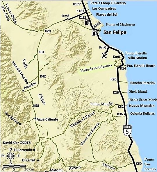
Directions: travel from San Felipe is Morelila road – east valley road – west valley roar to Carricitos corral and onward.
Since 3-2022 big summer storms and flooding the track after Carricitos corral (30 35.6191, -115 07.0336) was undefined. The GPS track from 2022 was
used, but now was missing. Soon I found some cow tracks that led me around bushes and debris to my GPS track and my road from 2022. The road soon
disappeared as it became a rocky arroyo. I had to rock crawl up the arroyo.
The arroyo got better as I traveled, then came to a dead end. I hiked for several minutes and found a parallel arroyo and proceeded to rock crawl the
crossover over the debris and boulders to the next arroyo. From there I traveled until I came to where the gate was marked on my GPS as at another
arroyo dead end. I took a short hike and found the gate in a pile of debris. I now carry a pruning saw and a small chain saw and the blockage was
quickly removed to allow passage using my pruning saw.
A hard turn around the gate debris led me back to my track and the road.
I took a side trip to the main Parral corral (30 30.6279, -115 06.5434) which is fenced with no outlet then returned to my faint road. Approaching the
arroyo crossing I used in 2022 I investigated both up stream and downstream and found it was not possible to cross anywhere else. The big boulders
from 2022 were buried so I was able to get a good approach to the bank. The bank was steeper than 2022 and as soon as I tried to go up the bank I
found very soft sand and dirt mix with very large rocks. I proceed to get stuck which took a little back and forth to backup and try again. Nothing
above to attach a winch to and after several more attempts I turned around hand headed back to San Felipe.
Then I made a wrong turn at a Y where the two tracks join. I followed my 2022 track instead of the new 2024 track I had just made. I cannot imagine
why I did that - really dumb. Got stuck and after several hours I sent several emails and text messages to my wife a daughter to tell them to get
help. Time around 1PM. That place is 30 32.244, -115 05.6554. I use my winch every which way and proceed to kill my battery. Easily corrected with my
lithium jump start. (The battery never recovered and I had to buy a new one).
My winching effort was defeated because I needed three snatch blocks to be able to pull from the rear and I only carry one of them. Yup, more stuff to
carry.
I ended up with no traction on front due to the soft sand and in the rear the tires were buried. To make it worst a big Palo Verde tree that had to
be cut down to the ground to make a possible path to back up. The battery powered chain saw took care of that in a few minutes. Four big 4” trunks
and then the base was 8-10” diameter. Dragging the tree limbs aside took longer.
My wife called Rich Tiesso and he and Harvey Schuler headed to where I was. Before Rich left my house he examined my inReach map share image and
copied down certain important way points. I guess that was around 4PM
Yes the two guys spent a lot of time looking for my tracks at Carricitos corral just like I did and they did the same thing for the arroyo crossover.
At 1:30 AM Rich and Harvey arrived at my location wan woke me up. A simple pull got me unstuck. Got home at 4:30AM
[Edited on 4-12-2024 by PaulW]
|
|
|
mtgoat666
Select Nomad
Posts: 17335
Registered: 9-16-2006
Location: San Diego
Member Is Offline
Mood: Hot n spicy
|
|
Leave no trace!
Better to stop early and walk instead of getting into situation where you have to cut down mature trees!
Woke!
“...ask not what your country can do for you – ask what you can do for your country.” “My fellow citizens of the world: ask not what America
will do for you, but what together we can do for the freedom of man.”
Prefered gender pronoun: the royal we
|
|
|
PaulW
Ultra Nomad
Posts: 3009
Registered: 5-21-2013
Member Is Offline
|
|
Thanks
Lots of storms since 3-2022 so I fixed the writeup.
I think I included your 2004 Parral trip several post above.
| Quote: Originally posted by David K | Check the year, Paul. Not yet "summer 2024".
I love the Valle Chico canyons, keep posting about them.
Shall I repost the bajalou article? |
|
|
|
pacificobob
Super Nomad
Posts: 2241
Registered: 4-23-2006
Member Is Offline
|
|
Good post Paul, thanks
|
|
|
David K
Honored Nomad
Posts: 64490
Registered: 8-30-2002
Location: San Diego County
Member Is Offline
Mood: Have Baja Fever
|
|
| Quote: Originally posted by PaulW | Update 3-26/27-2024
Summary - The track to get to the Parral ruins is pretty grim now days. And has become one of the more difficult near San Felipe. Was worse than my
2022 trip which stayed out of the arroyos.
Directions: travel from San Felipe is Morelila road – east valley road – west valley roar to Carricitos corral and onward.
Since 3-2022 big summer storms and flooding the track after Carricitos corral (30 35.6191, -115 07.0336) was undefined. The GPS track from 2022 was
used, but now was missing. Soon I found some cow tracks that led me around bushes and debris to my GPS track and my road from 2022. The road soon
disappeared as it became a rocky arroyo. I had to rock crawl up the arroyo.
The arroyo got better as I traveled, then came to a dead end. I hiked for several minutes and found a parallel arroyo and proceeded to rock crawl the
crossover over the debris and boulders to the next arroyo. From there I traveled until I came to where the gate was marked on my GPS as at another
arroyo dead end. I took a short hike and found the gate in a pile of debris. I now carry a pruning saw and a small chain saw and the blockage was
quickly removed to allow passage using my pruning saw.
A hard turn around the gate debris led me back to my track and the road.
I took a side trip to the main Parral corral (30 30.6279, -115 06.5434) which is fenced with no outlet then returned to my faint road. Approaching the
arroyo crossing I used in 2022 I investigated both up stream and downstream and found it was not possible to cross anywhere else. The big boulders
from 2022 were buried so I was able to get a good approach to the bank. The bank was steeper than 2022 and as soon as I tried to go up the bank I
found very soft sand and dirt mix with very large rocks. I proceed to get stuck which took a little back and forth to backup and try again. Nothing
above to attach a winch to and after several more attempts I turned around hand headed back to San Felipe.
Then I made a wrong turn at a Y where the two tracks join. I followed my 2022 track instead of the new 2024 track I had just made. I cannot imagine
why I did that - really dumb. Got stuck and after several hours I sent several emails and text messages to my wife a daughter to tell them to get
help. Time around 1PM. That place is 30 32.244, -115 05.6554. I use my winch every which way and proceed to kill my battery. Easily corrected with my
lithium jump start. (The battery never recovered and I had to buy a new one).
My winching effort was defeated because I needed three snatch blocks to be able to pull from the rear and I only carry one of them. Yup, more stuff to
carry.
I ended up with no traction on front due to the soft sand and in the rear the tires were buried. To make it worst a big Palo Verde tree that had to
be cut down to the ground to make a possible path to back up. The battery powered chain saw took care of that in a few minutes. Four big 4” trunks
and then the base was 8-10” diameter. Dragging the tree limbs aside took longer.
My wife called Rich Tiesso and he and Harvey Schuler headed to where I was. Before Rich left my house he examined my inReach map share image and
copied down certain important way points. I guess that was around 4PM
Yes the two guys spent a lot of time looking for my tracks at Carricitos corral just like I did and they did the same thing for the arroyo crossover.
At 1:30 AM Rich and Harvey arrived at my location wan woke me up. A simple pull got me unstuck. Got home at 4:30AM
[Edited on 4-12-2024 by PaulW] |
My word, what determination!
The road was easy in 2004 and Lou (who met me at the unlocked Parral road gate) was so jazzed as it was locked the previous trips.
Once through the gate, the road shared a bush pilot landing strip* to the corral which was built on the road! There was a track that went around the
south side of the corral that could be seen on Google Earth, but not us.
We all camped at the Corral and got some April showers before it was campfire time.
I always love the campfire chats with my Baja amigos!
*Cerro Chato 2,300ft long, elev. 2,781'. Inspected by Galen Hanselman on 6/97.
|
|
|
PaulW
Ultra Nomad
Posts: 3009
Registered: 5-21-2013
Member Is Offline
|
|
As I mentioned I drove into the corral fenced area and then looked for the road when I exited. I thought there was a track to head south. What I found
were full sized dead trees and no sign of a path that way.
The corral looks good - no vegetation growing there and no signs of the cows.
Maybe there was a fire to kill the full size trees. I did not stop to examine. A short distant back on the corral road is a faint path at a Y that
leads to the arroyo crossing. I used that same path at in 2022.
Now days all the roads have vegetation that is as high as 4'. Flimsy and just drive over the plants. The plants are still there an will continue to
grow until the next dry cycle arrives.
Just past the demolished gate there is no sign of a landing strip, but a new wash, on the N side, continues parallel the the road after the gate.
Heavy tall vegetation along the road in that area so there was no visibility to the sides.
|
|
|
| Pages:
1
2 |


