| Pages:
1
2
3 |
1Bajalover
Nomad

Posts: 195
Registered: 1-30-2011
Member Is Offline
Mood: UP
|
|
Mexicali Border Crossing
does anyone have suggestions for how to simplify being in the correct lane to cross the border without things getting complicated?
I am sorry if this has been posted elsewhere but have not seen it and have heard from several people that got pulled over and repremended for being in
the wrong lane
Thank You!
|
|
|
JZ
Elite Nomad
Posts: 9229
Registered: 10-3-2003
Member Is Online
|
|
The night before you cross, study the route on Google Maps. I make sure it is going to take me to the Sentri lane.
Have a co-pilot help you navigate. Watch the signs closely. Go slow.
Use a phone based GPS app like Gaia to track your route so you can use it for future crossings.
[Edited on 4-17-2022 by JZ]
|
|
|
WestyWanderer
Nomad
Posts: 276
Registered: 10-24-2014
Location: San Clemente, CA
Member Is Offline
|
|
Which Mexicali crossing, east or west?
|
|
|
BornFisher
Super Nomad
Posts: 2103
Registered: 1-11-2005
Location: K-38 Santa Martha/Encinitas
Member Is Online
|
|
Which direction, north or south?
"When you catch a fish, you open the door of happiness."
|
|
|
JZ
Elite Nomad
Posts: 9229
Registered: 10-3-2003
Member Is Online
|
|
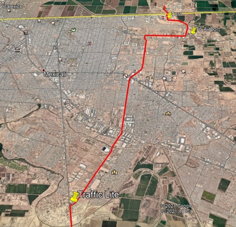
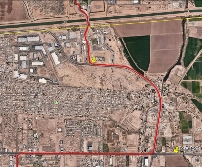
Here is an alternative route to the East crossing I've taken before. It takes you by the airport. The benefit of this route is it takes you through
farm land and avoids even more of the Mexicali city traffic.
The one weird thing is you have to do a U turn to get on the road to start going East off of MX 5.
This route is definitely lower stress.
https://goo.gl/maps/RLrpgfnFjtBLejZd7

[Edited on 4-17-2022 by JZ]
|
|
|
mtgoat666
Select Nomad
Posts: 17295
Registered: 9-16-2006
Location: San Diego
Member Is Offline
Mood: Hot n spicy
|
|
Quote: Originally posted by JZ  | Here is an alternative route to the East crossing I've taken before. It takes you by the airport. The benefit of this route is it takes you through
farm land and avoids even more of the Mexicali city traffic.
The one weird thing is you have to do a U turn to get on the road to start going East off of MX 5.
This route is definitely lower stress.
https://goo.gl/maps/RLrpgfnFjtBLejZd7
[Edited on 4-17-2022 by JZ] |
Sort of a long route there, short stuff.
Take the 2 for faster travel.
The east approach of the the border is for regular lane, the west approach is for sentri and ready.
Woke!
“...ask not what your country can do for you – ask what you can do for your country.” “My fellow citizens of the world: ask not what America
will do for you, but what together we can do for the freedom of man.”
Prefered gender pronoun: the royal we
|
|
|
1Bajalover
Nomad
Posts: 195
Registered: 1-30-2011
Member Is Offline
Mood: UP
|
|
I am going north - crossing from Mexico into California-
it certainly looks complicated?
I am not a sentri person
and am traveling solo
I understand it can get confusing and people easily end
up in the sentri lane and get pulled over and hastled
(treated as tho they did it on purpose etc)
Thank you for these maps everyone
they will be very helpful I am sure
after studying them there may be more questions
|
|
|
chippy
Super Nomad
Posts: 1697
Registered: 2-2-2010
Member Is Offline
|
|
if you are going to socal cross at tecate.
|
|
|
David K
Honored Nomad
Posts: 64479
Registered: 8-30-2002
Location: San Diego County
Member Is Offline
Mood: Have Baja Fever
|
|
| Quote: Originally posted by 1Bajalover | I am going north - crossing from Mexico into California-
it certainly looks complicated?
I am not a sentri person
and am traveling solo
I understand it can get confusing and people easily end
up in the sentri lane and get pulled over and hastled
(treated as tho they did it on purpose etc)
Thank you for these maps everyone
they will be very helpful I am sure
after studying them there may be more questions
|
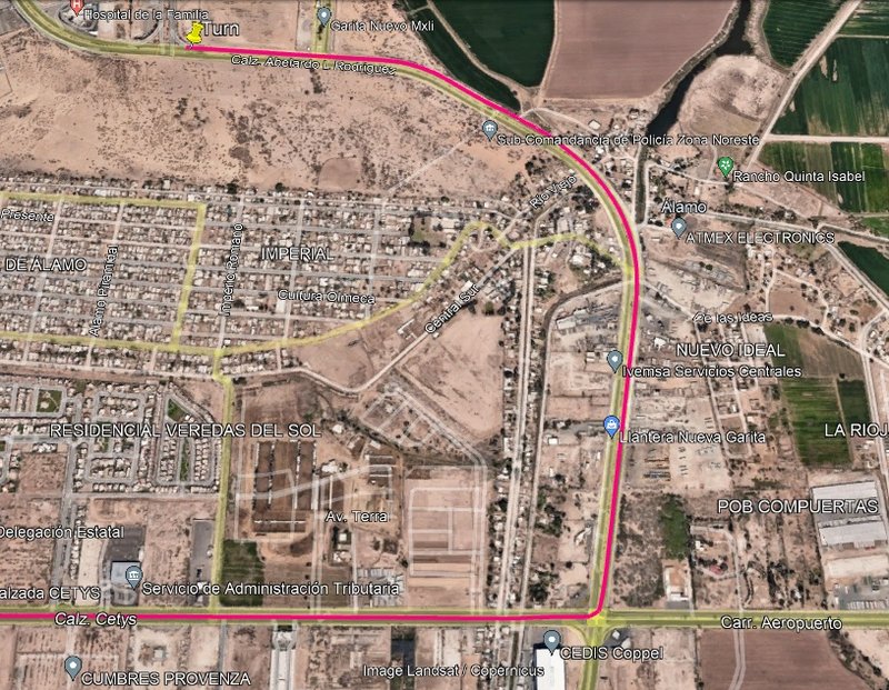
In 2019, here on Nomad, I posted photos of the way showing the signs, to the non-Sentri lane (required a u-turn the way we went, following someone
going to the Sentri line. It was easy).
The photos have the Photobucket watermark to ignore, if you can:
| Quote: Originally posted by David K | We followed Bulletproof Diesel who knew the muy rápido way to the east border crossing. The border wait was reported very low on this Friday
afternoon.
The first deviation off Hwy. 5 occurred before the RR track crossing traffic circle. This is by the Kenworth and near Costco...
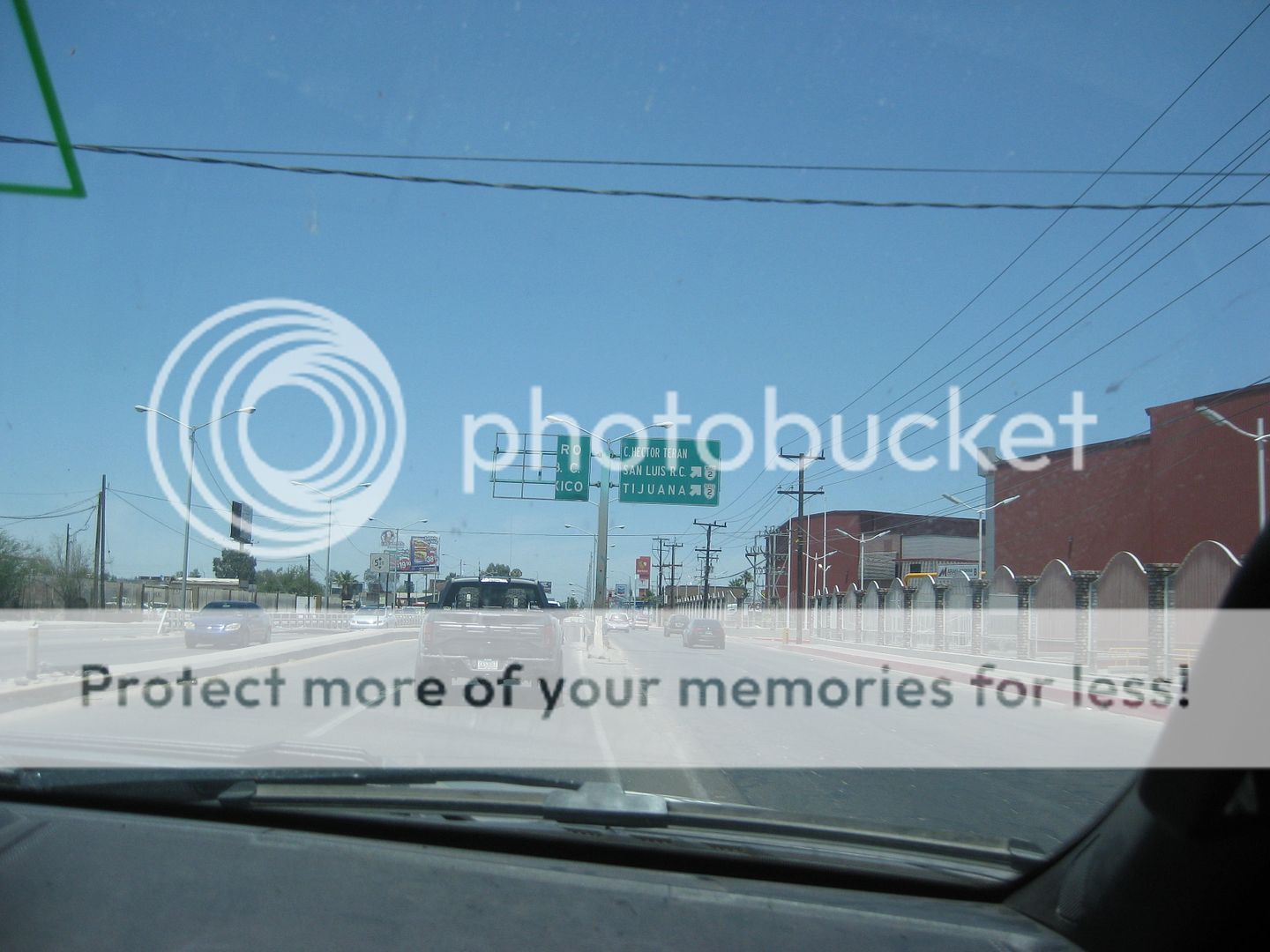
Get into the middle lane and go down... turning right ahead.
There are no turns until you reach the border wall using this route.

Passing the Kenworth building
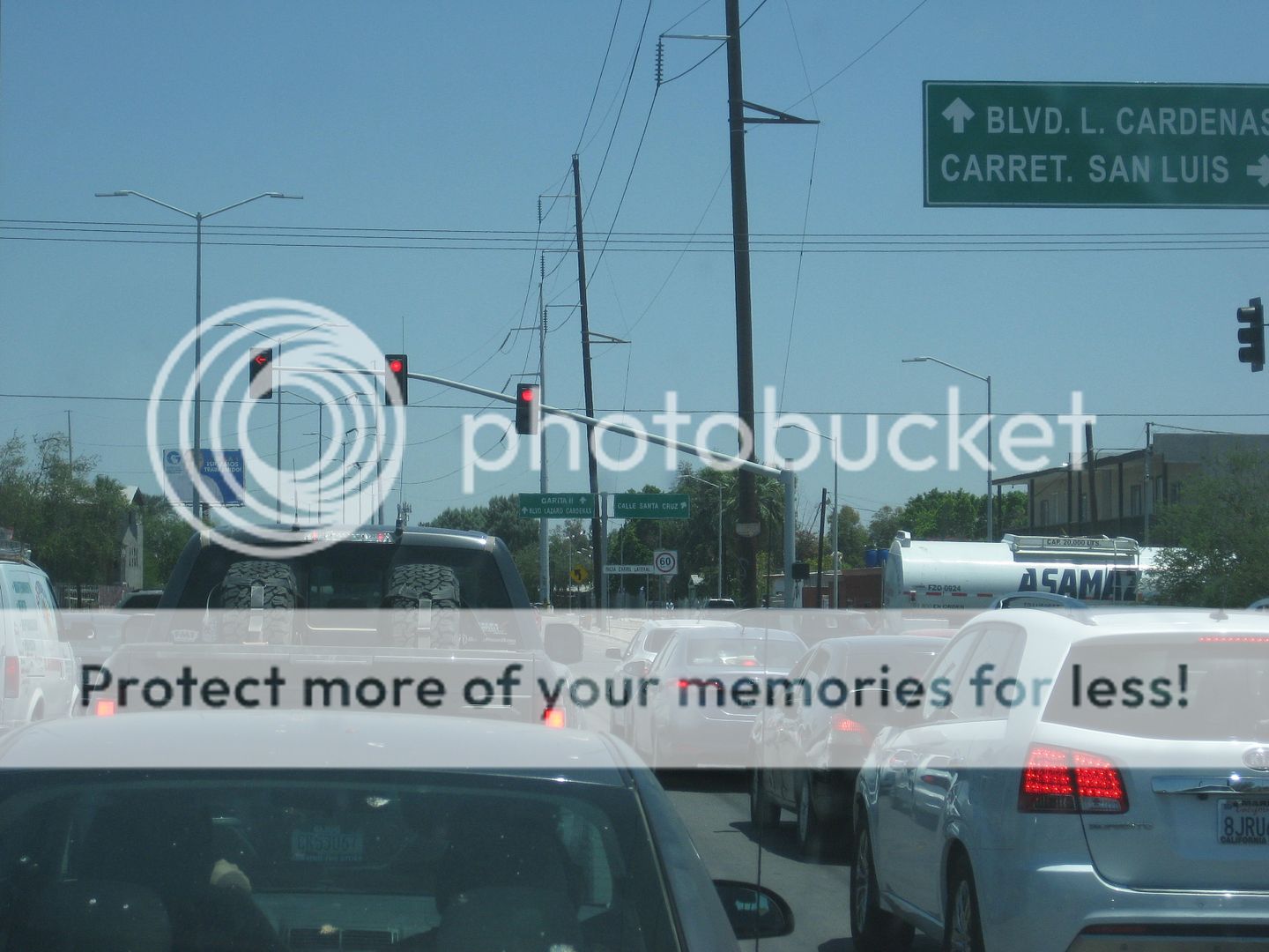
Crossing Hwy. 2

See Garita II on the sign?
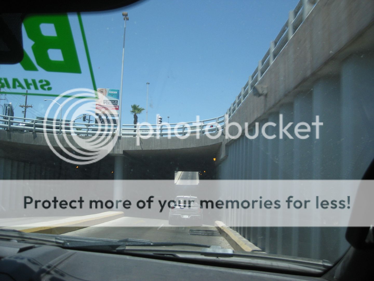
Under this road.
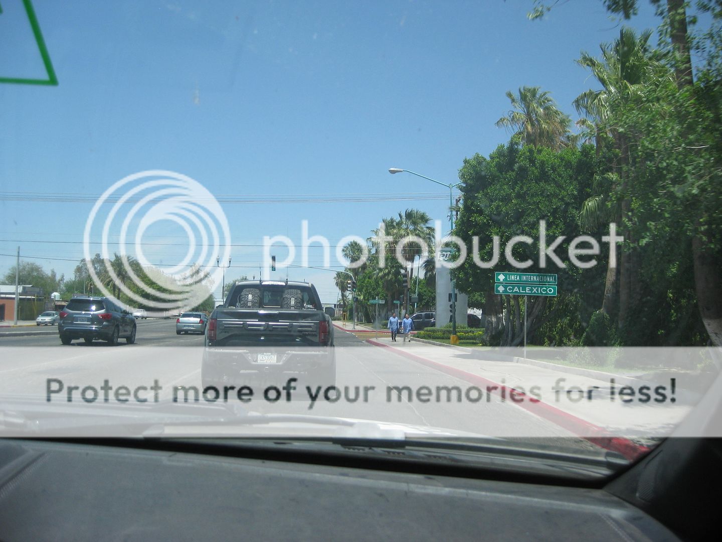
See Calexico sign?
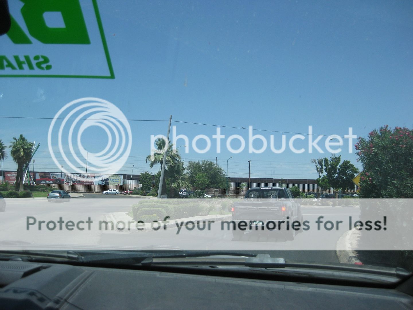
Turn right as you see the border fence.
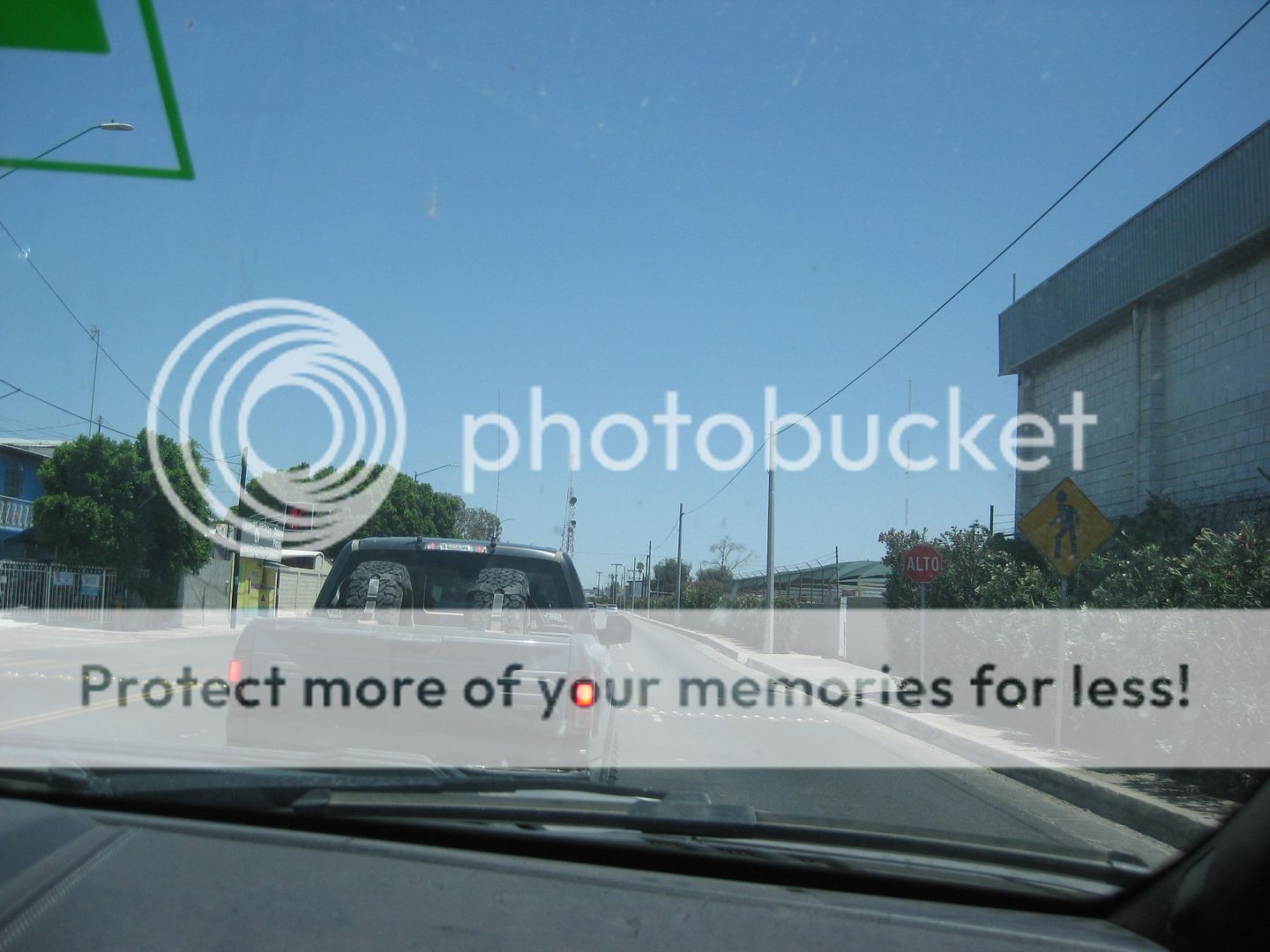

Pass an ARCO station.
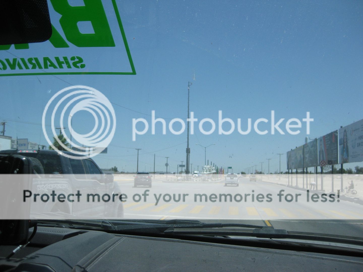
Here Bulletproof truck turns for the Sentri Lane... we continue on to where we can make a U-turn and enter the regular lane.

Garita II is the border.

Trucks and Cars regular lane.
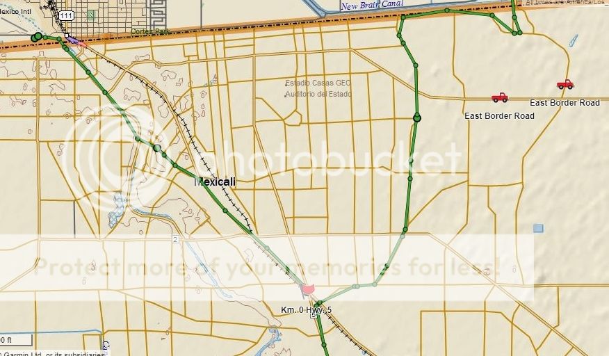
The GPS track of the Mexicali routes we took.
That ends the trip report. Six days, 3,000 miles, lots of fun and new sites to see for all of us. I was so happy to finally see San Bruno and San
Pablo, too.
The Trail of Mission tour that this recon and filming was for is the last week of June. Cameron has 60 guests, so maybe up to 25 Raptors and other
4x4s? The cost now $7,000 per vehicle (2 adults and children), and this includes rooms and meals, with AB Catering the meals in remote locations
(Alek's food is awesome) https://www.facebook.com/aboffthegridcatering/. The requests to join the tour are so many Cameron has to turn people away.
The TV show of the tour will be on ABC on Sept. 7. This is the 6th Trail of Missions tour. I was on the first for 3 days, flying to the group and
returning in the helicopter flown by Jim McCoy out of El Cajon.
You can see all but the first show on YouTube. The first show was on CBS Sports and is online, but requires a password. I can share that with anyone
who asks, send me a u2u or email.
I hope you enjoyed the ride!
David
|
|
|
|
PaulW
Ultra Nomad
Posts: 3005
Registered: 5-21-2013
Member Is Offline
|
|
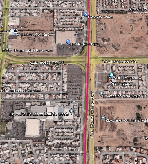
1Bajalover,
Mexicali east only
Ok, here is the correct answer and avoids a U-turn that Google makes you use that is seldom possible.
First disregard Google maps and other maps and instructions presented above.
Google maps leads you to Sentri and Ready and you need standard Which
means you need to approach the border entry from the east not the west. These Nomads will ague all day that from the west works, but after 18 years of
doing this crossing for sure east always works and is easy.
Here are the easy instructions - write them down in order:
From Hwy 5 turn right at the first traffic light thru the industrial area. Go straight at all choices and pass the Coco Cola building and a major
bank. Cross the San Luis highway at RR tracks and continue going straight.
The road leads you northerly past a Calimax and to a major intersection with a huge new high rise shopping building. At that point turn right onto
the Airport road which is a 6 lane highway. Use left lane and turn left at a major intersection identified by a multistory warehouse on the SW corner
and a Large gas station on the SW corner. See a Garita sign.
Follow the road in the second lane from the right and then move to the right lane after all the semis turn north.
The key sign to watch for is Garita. Find it along the way at various intersections.
=== ==
Quote: Originally posted by 1Bajalover
I am going north - crossing from Mexico into California-
it certainly looks complicated?
I am not a sentri person
and am traveling solo
I understand it can get confusing and people easily end
up in the sentri lane and get pulled over and hastled
(treated as tho they did it on purpose etc)
Thank you for these maps everyone
they will be very helpful I am sure
after studying them there may be more questions
In 2019, here on Nomad, I posted photos of the way showing the signs, to the non-Sentri lane (required a u-turn the way we went, following someone
going to the Sentri line. It was easy).
Please disregard the highway signs on the following image.
Standby while I dig out a better map
|
|
|
PaulW
Ultra Nomad
Posts: 3005
Registered: 5-21-2013
Member Is Offline
|
|
Standard land Mexicali East maps
GPS tracks imbedded on Google earth
|
|
|
JZ
Elite Nomad
Posts: 9229
Registered: 10-3-2003
Member Is Online
|
|
| Quote: Originally posted by PaulW |
Ok, here is the correct answer and avoids a U-turn that Google makes you use that is seldom possible.
First disregard Google maps and other maps and instructions presented above.
Google maps leads you to Sentri and Ready and you need standard Which
means you need to approach the border entry from the east not the west. These Nomads will ague all day that from the west works, but after 18 years of
doing this crossing for sure east always works and is easy.
Here are the easy instructions - write them down in order:
From Hwy 5 turn right at the first traffic light thru the industrial area. Go straight at all choices and pass the Coco Cola building and a major
bank. Cross the San Luis highway at RR tracks and continue going straight.
The road leads you northerly past a Calimax and to a major intersection with a huge new high rise shopping building. At that point turn right onto
the Airport road which is a 6 lane highway. Use left lane and turn left at a major intersection identified by a multistory warehouse on the SW corner
and a Large gas station on the SW corner. See a Garita sign.
Follow the road in the second lane from the right and then move to the right lane after all the semis turn north.
The key sign to watch for is Garita. Find it along the way at various intersections.
=== ==
|
The 2nd route I posted comes in from the East. Near the airport it starts following the route you posted. It just swings further East outside the
city at the beginning.
For sure you want to follow Google Maps turn by turn directions. You just need to set a 1st stop (like the airport) that makes it come in from the
East to the 2nd spot (border).
No way I'm trying to memorize directions that say turn right by the big red building with the hot dog cart out front.
Use technology ppl. Just vetted it first. In fact, in a couple minutes you could add 1 or 2 additional stops to have Google Maps follow the exact
path you typed out. Then when you are driving it tells you exactly what to do and gives you advance notice of turns.
[Edited on 4-18-2022 by JZ]
|
|
|
mtgoat666
Select Nomad
Posts: 17295
Registered: 9-16-2006
Location: San Diego
Member Is Offline
Mood: Hot n spicy
|
|
Worst advice ever! Tecate require ridiculous detour thru mountains, HUGE waste of time.
Woke!
“...ask not what your country can do for you – ask what you can do for your country.” “My fellow citizens of the world: ask not what America
will do for you, but what together we can do for the freedom of man.”
Prefered gender pronoun: the royal we
|
|
|
mtgoat666
Select Nomad
Posts: 17295
Registered: 9-16-2006
Location: San Diego
Member Is Offline
Mood: Hot n spicy
|
|
Good route 
Woke!
“...ask not what your country can do for you – ask what you can do for your country.” “My fellow citizens of the world: ask not what America
will do for you, but what together we can do for the freedom of man.”
Prefered gender pronoun: the royal we
|
|
|
Lee
Ultra Nomad
Posts: 3455
Registered: 10-2-2006
Location: High in the Colorado Rockies
Member Is Offline
|
|
This is the best route to avoid town. Memorize the land marks and street names.
US Marines: providing enemies of America an opportunity to die for their country since 1775.
What I say before any important decision.
F*ck it.
|
|
|
mtgoat666
Select Nomad
Posts: 17295
Registered: 9-16-2006
Location: San Diego
Member Is Offline
Mood: Hot n spicy
|
|
Why memorize the route? That’s what maps are for. Hard copy or smart phone better than memorizing.
Woke!
“...ask not what your country can do for you – ask what you can do for your country.” “My fellow citizens of the world: ask not what America
will do for you, but what together we can do for the freedom of man.”
Prefered gender pronoun: the royal we
|
|
|
PaulW
Ultra Nomad
Posts: 3005
Registered: 5-21-2013
Member Is Offline
|
|
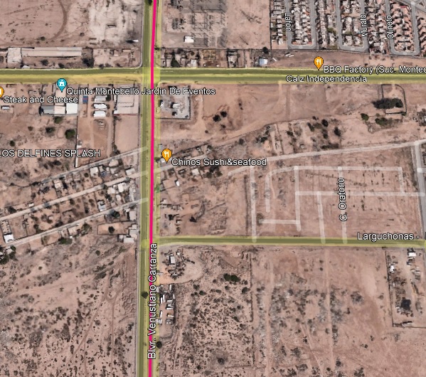
Street Names
Street names
From Hwy 5 to the standard east border. Note the street name changes along the way.
 photo image hosting com photo image hosting com

|
|
|
Mulege Canuck
Nomad
Posts: 386
Registered: 11-27-2016
Member Is Offline
|
|
That is the way I go through Mexicali. Good route
|
|
|
Purdyd
Nomad
Posts: 125
Registered: 10-21-2018
Member Is Offline
|
|
These are great maps to the Mexicali east border crossing.
But if you come in from the east can you turn right into the global sentri lane?
Is it marked?
Google maps ain’t exactly clear on how that works and it looks to be setup for a left turin coming in from the west?
I’ll be coming back through in May and haven’t driven across that border crossing in well, a long time.
Sorry I see it now, I assume right at the alto sign.

[Edited on 4-18-2022 by Purdyd]
|
|
|
TSThornton
Junior Nomad
Posts: 60
Registered: 8-25-2021
Member Is Offline
|
|
Last November, I used the regular lanes at the West crossing. Took 3 hours. Registered my truck for Sentri when I got home. This past Friday, I
accessed the East crossing Sentri lane via the directions Google Maps gave me (same as what PaulW posted) and it was so great. The bypass around the
city was smooth and there was 0 wait. Rolled right through with the only stop being for less than one minute at the booth.
The most notable thing was the insane stream of cars moving south for Easter weekend! The beaches from San Felipe down through the popular ones south
of Mulege were all already jam packed. I don't know where everyone was going to find a place to camp!
|
|
|
| Pages:
1
2
3 |


