| Pages:
1
2 |
David K
Honored Nomad

Posts: 64479
Registered: 8-30-2002
Location: San Diego County
Member Is Offline
Mood: Have Baja Fever
|
|
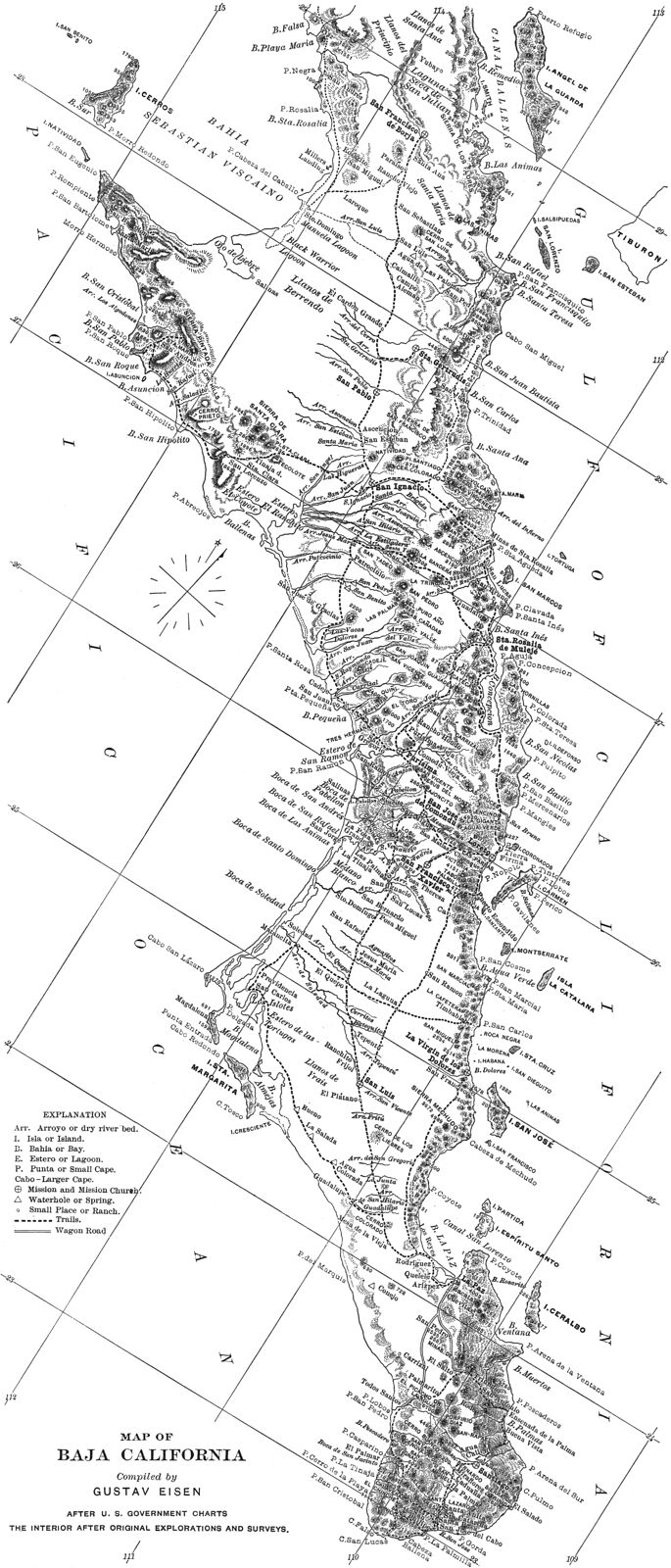
Map from 1900: San Borja to Cabo San Lucas
Thanks to 'geoffff' for stitching three maps together to produce this:
|
|
|
David K
Honored Nomad
Posts: 64479
Registered: 8-30-2002
Location: San Diego County
Member Is Offline
Mood: Have Baja Fever
|
|
On the www.VivaBaja.com/maps page, this map can be clicked to zoom way in for reading details!
|
|
|
4x4abc
Ultra Nomad
Posts: 4163
Registered: 4-24-2009
Location: La Paz, BCS
Member Is Offline
Mood: happy - always
|
|
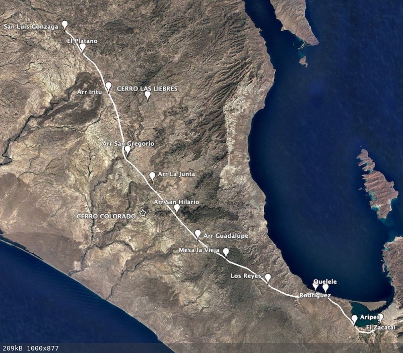
there is this ominous Cerro Colorado on all old maps.
also on this one
But not on any of the new maps.
Any experts here to pinpoint Cerro Colorado?
it seems about 10 miles east of MEX1
and a bit north of the powerline to San Juan de la Costa
I can pinpoint Mesa de la Vieja
and Arroyo Guadalupe
I have some candidates but nothing really high to deserve a spot on the map

Harald Pietschmann
|
|
|
4x4abc
Ultra Nomad
Posts: 4163
Registered: 4-24-2009
Location: La Paz, BCS
Member Is Offline
Mood: happy - always
|
|
figured it out myself
the old problem - map makers who have no knowledge of the area they are mapping
starting in La Paz Mr Eisen misplaced Zacatal
so the following waypoints are off
Rancho Los Reyes is in the ocean
he did not know what to do with it, so he put it in the water
Mesa de la Vieja is actually Los Reyes
CERRO COLORADO is Mesa de la Vieja
the real Cerro Colorado is west of Camino Real
from Arroyo Guadalupe all locations match
could not find La Junta - possibly Arr Las Pocitas
Harald Pietschmann
|
|
|
geoffff
Senior Nomad
Posts: 643
Registered: 1-15-2009
Member Is Offline
|
|
Quote: Originally posted by 4x4abc  | figured it out myself
the old problem - map makers who have no knowledge of the area they are mapping |
beautifully crafted map, but so wrong
|
|
|
geoffff
Senior Nomad
Posts: 643
Registered: 1-15-2009
Member Is Offline
|
|
The author, Gustav Eisen
https://alchetron.com/Gustav-Eisen

|
|
|
bajaric
Senior Nomad
Posts: 602
Registered: 2-2-2015
Member Is Offline
|
|
4 worms, 2 red algae, two plants and a mosquito named after him. Impressive!
|
|
|
David K
Honored Nomad
Posts: 64479
Registered: 8-30-2002
Location: San Diego County
Member Is Offline
Mood: Have Baja Fever
|
|
Cerro Colorado, west of La Paz, on a 1919 map:
https://octopup.org/img/media/maps/baja/1919--Baja-Californi...
|
|
|
4x4abc
Ultra Nomad
Posts: 4163
Registered: 4-24-2009
Location: La Paz, BCS
Member Is Offline
Mood: happy - always
|
|
bad map
wrong location for Cerro Colorado
it is north of Arroyo San Hilario
24.416464°, -111.053427°
between El Cien and Las Pocitas
these US maps are pretty accurate along the coast
but inland they are usually oof
however, the 1923 US map is one of my favorites for the old trail network
everything, including Camino Real are right on
Harald Pietschmann
|
|
|
surfhat
Nomad
Posts: 493
Registered: 6-4-2012
Member Is Offline
|
|
After all these years since I first drive down the 1 to Cabo and found a dirt road south of Todos Santos in the middle of the night and coming upon a
night club north of Cabo San Lucas at 3am partying on relentlessly, I have to say it was quite a culture shock.
Looking back, my girlfriend and I should have stopped and joined the party. Our intentions were to catch the morning ferry from Cabo to Puerto
Vallarta.sp? duh.
It was not much longer before that ferry stopped running, and for good reasons. The open ocean was not conducive to such an open ocean voyage that i
had the privilege to experience.
The odor of puke on that overnight trip had me spending the night on the deck for the fresh air.
Certain memories pop up when something reminds me of past personal experiences. This is just another.
Please carry on if I have gone off topic. I can easily be triggered by all I have seen in the last fifty years of loving everything about Mexico and
its salt of the earth people. Peace out.
|
|
|
4x4abc
Ultra Nomad
Posts: 4163
Registered: 4-24-2009
Location: La Paz, BCS
Member Is Offline
Mood: happy - always
|
|
| Quote: Originally posted by surfhat | After all these years since I first drive down the 1 to Cabo and found a dirt road south of Todos Santos in the middle of the night and coming upon a
night club north of Cabo San Lucas at 3am partying on relentlessly, I have to say it was quite a culture shock.
Looking back, my girlfriend and I should have stopped and joined the party. Our intentions were to catch the morning ferry from Cabo to Puerto
Vallarta.sp? duh.
It was not much longer before that ferry stopped running, and for good reasons. The open ocean was not conducive to such an open ocean voyage that i
had the privilege to experience.
The odor of puke on that overnight trip had me spending the night on the deck for the fresh air.
Certain memories pop up when something reminds me of past personal experiences. This is just another.
Please carry on if I have gone off topic. I can easily be triggered by all I have seen in the last fifty years of loving everything about Mexico and
its salt of the earth people. Peace out.
|
carry on!
the best conversations start at X, go to Z and end up at B
and B usually being much more interesting than X
Harald Pietschmann
|
|
|
watizname
Senior Nomad
Posts: 769
Registered: 8-7-2009
Member Is Offline
|
|
| Quote: Originally posted by 4x4abc | | Quote: Originally posted by surfhat | After all these years since I first drive down the 1 to Cabo and found a dirt road south of Todos Santos in the middle of the night and coming upon a
night club north of Cabo San Lucas at 3am partying on relentlessly, I have to say it was quite a culture shock.
Looking back, my girlfriend and I should have stopped and joined the party. Our intentions were to catch the morning ferry from Cabo to Puerto
Vallarta.sp? duh.
It was not much longer before that ferry stopped running, and for good reasons. The open ocean was not conducive to such an open ocean voyage that i
had the privilege to experience.
The odor of puke on that overnight trip had me spending the night on the deck for the fresh air.
Certain memories pop up when something reminds me of past personal experiences. This is just another.
Please carry on if I have gone off topic. I can easily be triggered by all I have seen in the last fifty years of loving everything about Mexico and
its salt of the earth people. Peace out.
|
carry on!
the best conversations start at X, go to Z and end up at B
and B usually being much more interesting than X |
That's the best comment I have heard in a looooong time Harold. 
I yam what I yam and that\'s all what I yam.
|
|
|
4x4abc
Ultra Nomad
Posts: 4163
Registered: 4-24-2009
Location: La Paz, BCS
Member Is Offline
Mood: happy - always
|
|
Gracias!
Harald Pietschmann
|
|
|
David K
Honored Nomad
Posts: 64479
Registered: 8-30-2002
Location: San Diego County
Member Is Offline
Mood: Have Baja Fever
|
|
Drifting off topic, just a little? 
|
|
|
4x4abc
Ultra Nomad
Posts: 4163
Registered: 4-24-2009
Location: La Paz, BCS
Member Is Offline
Mood: happy - always
|
|
sorry David - we'll keep it more simple for you.
Harald Pietschmann
|
|
|
David K
Honored Nomad
Posts: 64479
Registered: 8-30-2002
Location: San Diego County
Member Is Offline
Mood: Have Baja Fever
|
|
Simple? As in old maps vs. new astronomy?
I get how old minds can wander off... I am not that much younger than you, am I?
LOL
|
|
|
4x4abc
Ultra Nomad
Posts: 4163
Registered: 4-24-2009
Location: La Paz, BCS
Member Is Offline
Mood: happy - always
|
|
that image inserted itself - I did not intend it to be there
Harald Pietschmann
|
|
|
bajaric
Senior Nomad
Posts: 602
Registered: 2-2-2015
Member Is Offline
|
|
The 1900 map has more than a few inaccuracies, but that could be expected. By then the coastline had been charted but parts of the interior were
still "terra incognito".
For example, the map shows a wagon trail from the coastline to what today is called Punta Prieta (town). This trail actually existed, to supply mines
in the interior by sea from the landing at what was then called Santa Rosalia.
Then the map shows a trail north, passing the area known today for the "Lions" (Leon Grande, Arroyo Leoncito, etc.) but the route was probably only a
guess upon the part of Eisen, based on something he had heard. This is the fabled "western trail" that has been discussed before, a north/south trail
that was well to the west of the old mission trail north from San Borja in the period around 1900. It was probably never more than a burro path and
was abandoned when a better road north from Punta Prieta went in around 1920 -1930.
|
|
|
David K
Honored Nomad
Posts: 64479
Registered: 8-30-2002
Location: San Diego County
Member Is Offline
Mood: Have Baja Fever
|
|
I think we know these old maps are not as accurate as those made over 100 years later (although I have seen some pretty bad new maps).
Look again at the legend... the only 'wagon road' is south from La Paz. Other dashed lines are simply called 'trails'.
I do not see Punta Prieta or anything where Punta Prieta is, on the map. The only places beyond Mission San Francisco Borja are Yubay (north) and San
Andrés (west). Those two places exist to this day.
Indeed the trail north from San Borja was not much more than a burro path as the Jesuits were expelled the year (1767) after they established the next
mission beyond San Borja (first at Calamajué in 1766). They never had the time to build a proper road as they had from Loreto to San Borja. The
Franciscans and Dominicans, who replaced the Jesuits in California, had no interest in road building like the Jesuits made... beyond what was needed
for pack trains of burros, and for people on mules & horses.
I hope we will find more old maps to share and discuss. The region between San Borja and El Rosario is an interesting one (as are so many other parts
of Baja!).
|
|
|
bajaric
Senior Nomad
Posts: 602
Registered: 2-2-2015
Member Is Offline
|
|
You are right DK! After taking a closer look I see that Eisen's map does not show a trail from Santa Rosalillita (then called Santa Rosalia) to the
area of Punta Prieta (the town). It shows a more coastal route, passing Rancho San Andreas near the Pacific Ocean and proceeding north along the
coast. This may have been a trail that went to Rancho Cordonices?
Thus another wrinkle is added to the mystery north / south route that ran to the west of El Camino Real. around 1900-1920. It should be noted that at
the time steamships provided regular passenger service to landings all along both coastlines, providing a much easier way to get to central Baja than
by burro trail; a ticket to Bahia Asuncion was $20US, meals included, which would have been preferrable to riding a burro for 250 miles in the desert!
The few that rode those trails back in the day were tough!
[Edited on 5-5-2022 by bajaric]
|
|
|
| Pages:
1
2 |


