| Pages:
1
2 |
BajaNomad
Super Administrator

Posts: 4969
Registered: 8-1-2002
Location: San Diego, CA
Member Is Offline
Mood: INTP-A
|
|
Online satellite maps
This just ROCKS. Google has just released an update to their (already top-notch) online mapping service, to include an option of seeing the satellite
image of where you are on the map.
I was poking around Baja-way... and thought many of you would want to also. Example attached is of downtown El Rosario, including the Baja Cactus
facility.
Look for the link in the top-right that says "Satellite":
http://maps.google.com
When I was young, I admired clever people. Now that I am old, I admire kind people.
â Rabbi Abraham Joshua Heschel
We know we must go back if we live, and we don`t know why.
â John Steinbeck, Log from the Sea of Cortez
Affordable Domain Name Registration/Management & cPanel Web Hosting:
https://www.regionalinternet.com |
|
|
Bruce R Leech
Elite Nomad
Posts: 6796
Registered: 9-20-2004
Location: Ensenada formerly Mulege
Member Is Offline
Mood: A lot cooler than Mulege
|
|
this is to cool thanks Doug
Bruce R Leech
Ensenada
 |
|
|
BajaNomad
Super Administrator
Posts: 4969
Registered: 8-1-2002
Location: San Diego, CA
Member Is Offline
Mood: INTP-A
|
|
I've sized both of these down - both in resolution and file size. This is the La Paz area. btw.. you might need to search for San Diego, then scroll
down (you can drag the map image).
When I was young, I admired clever people. Now that I am old, I admire kind people.
â Rabbi Abraham Joshua Heschel
We know we must go back if we live, and we don`t know why.
â John Steinbeck, Log from the Sea of Cortez
Affordable Domain Name Registration/Management & cPanel Web Hosting:
https://www.regionalinternet.com |
|
|
jide
Nomad
Posts: 245
Registered: 4-9-2003
Location: san diego
Member Is Offline
|
|
Thanks Doug!! This is Way Cool !!!!
Here's Sierra de San Francisco and Green Canon San Pablo cuttin through:
http://maps.google.com/maps?ll=32.813877,-117.245568&spn...
[Edited on 4-5-2005 by jide]
|
|
|
BajaNomad
Super Administrator
Posts: 4969
Registered: 8-1-2002
Location: San Diego, CA
Member Is Offline
Mood: INTP-A
|
|
I think that link is where you started from... on the south side of Mt. Soledad in San Diego....
I was scrolling through the Sierra San Francisco too... 
When I was young, I admired clever people. Now that I am old, I admire kind people.
â Rabbi Abraham Joshua Heschel
We know we must go back if we live, and we don`t know why.
â John Steinbeck, Log from the Sea of Cortez
Affordable Domain Name Registration/Management & cPanel Web Hosting:
https://www.regionalinternet.com |
|
|
jide
Nomad
Posts: 245
Registered: 4-9-2003
Location: san diego
Member Is Offline
|
|
Yep, sorry, I was emailing the link to a friend, and coy & paste the wrong one. It's been corrected, copy and paste, cuz the hyperlink is not
complete and wont ork if you just click on it.
|
|
|
bufeo
Senior Nomad
Posts: 793
Registered: 11-16-2003
Location: Santa Fe New Mexico
Member Is Offline
|
|
BajaNomad-
That's a good link. Thank you. Being a "map nut" I'm always looking for new material. One download that I like is http://www.keyhole.com
To get the full effect for Keyhole, though, you have to change your screen definition to 1024 X 768 pixels, and on many monitors that pulls the print
down to a level some persons don't like.
I took a good look at many of the maps on the Google site and though the watermark says ?2005 the maps are several years prior--not that that makes
much difference when looking at Baja.
I zeroed on the Punta Bufeo - Gonzaga area and tried to get in close but was given the "Sorry but we don't have imagery... ." Rats! I was hoping to
get "Up Close and Personal." 
On second thought, maybe that's not all bad.
|
|
|
woody with a view
PITA Nomad
Posts: 15937
Registered: 11-8-2004
Location: Looking at the Coronado Islands
Member Is Offline
Mood: Everchangin'
|
|
does a higher screen reso give more detail? or lower? as for seeing a vehicle on the road i can't, even zoomed in all the way. maybe i need to play
around somemore. but it is cool. seems there are surfers at google maps, because alot of cool places aren't available. not a bad thing, i guess.
|
|
|
bajalera
Super Nomad
Posts: 1875
Registered: 10-15-2003
Location: Santa Maria CA
Member Is Offline
|
|
Doug, that's really great. Thanks!
Lera
\"Very few things happen at the right time, and the rest never happen at all. The conscientious historian will correct these defects.\" -
Mark Twain
|
|
|
BajaNomad
Super Administrator
Posts: 4969
Registered: 8-1-2002
Location: San Diego, CA
Member Is Offline
Mood: INTP-A
|
|
| Quote: | Originally posted by bufeo
...One download that I like is http://www.keyhole.com
To get the full effect for Keyhole, though, you have to change your screen definition to 1024 X 768 pixels, and on many monitors that pulls the print
down to a level some persons don't like.
I took a good look at many of the maps on the Google site and though the watermark says ?2005 the maps are several years prior--not that that makes
much difference when looking at Baja.
|
Google acquired Keyhole about 6 months ago, and that is the technology they've used to offer this new service. Apparently maps are 6 to 12 months old
(I don't know if that applies to the Mexico images as well):
http://biz.yahoo.com/ap/050406/google_maps.html
--
Doug
[Edited on 4-6-2005 by BajaNomad]
When I was young, I admired clever people. Now that I am old, I admire kind people.
â Rabbi Abraham Joshua Heschel
We know we must go back if we live, and we don`t know why.
â John Steinbeck, Log from the Sea of Cortez
Affordable Domain Name Registration/Management & cPanel Web Hosting:
https://www.regionalinternet.com |
|
|
turtleandtoad
Senior Nomad
Posts: 730
Registered: 1-20-2005
Location: Wherever I park. See sig for current location.
Member Is Offline
Mood: Good if fishing
|
|
Laptop Resolution
I run my laptop at 1280x1024 and have no problems seeing the details on the maps.
However the problem of using it on the road is that wireless AirCards don't work on the Baja yet, and even Datastorm becomes useless in the Baja Sur.
Mike & Robin; Full-Time RV\'ers
37\' Georgetown w/3 slides & 275 Watts of Solar Power
06 Taco TRD
www.turtleandtoad.com
I am here
To paraphrase Frank Lloyd Wright; I\'m all in favor of keeping dangerous weapons out of the hands of fools. Let\'s start with keyboards. --
Mike Dean |
|
|
bufeo
Senior Nomad
Posts: 793
Registered: 11-16-2003
Location: Santa Fe New Mexico
Member Is Offline
|
|
| Quote: | Originally posted by grover
Imagine how handy it would be to have one of bajabus' satellite hookups out on the road.
When you get a little puzzled/curious which fork to take, just pull down the image and have a look.
I wonder what kind of resolution would be possible to have with a portable laptop? |
I don't know what satellite hookup bajabus has. I use Motosat Datastorm with a Toshiba Satellite laptop, and, indeed, recently I took a look
at a section of Baja not far from us to see where the different "forks" led. Resolution in that part of the world is not too good yet.
turtleandtoad, we're in touch with other Datastorm Users in Baja Sur, you just have to make sure you're using the Mex7 Satellite. The Galaxy
up north doesn't have a footprint that reaches that far. In the summer when we head north to trout waters, we'll switch to Galaxy.
In fact User #1165 is in La Paz right now and across the Sea of Cortez and further south is User #994.
In addition, I've been having fun with these maps while following our son-in-law and his teammate racing KTMs in the Tunisian Rally. Too bad I can't
see them 'live'.
|
|
|
turtleandtoad
Senior Nomad
Posts: 730
Registered: 1-20-2005
Location: Wherever I park. See sig for current location.
Member Is Offline
Mood: Good if fishing
|
|
Datastorm
Now you tell me! 
I was going to buy a Datastorm while at Quartzsite in January, before my trip to Baja Sur, but was told by the sales people (in two different booths)
that it wouldn't work that far south and west. So I didn't buy it.
No one even mentioned the Mexico 7 satellite. Bummer!
Mike & Robin; Full-Time RV\'ers
37\' Georgetown w/3 slides & 275 Watts of Solar Power
06 Taco TRD
www.turtleandtoad.com
I am here
To paraphrase Frank Lloyd Wright; I\'m all in favor of keeping dangerous weapons out of the hands of fools. Let\'s start with keyboards. --
Mike Dean |
|
|
PJC
Super Nomad
Posts: 1670
Registered: 3-28-2003
Location: EVERYWHERE
Member Is Offline
Mood: Right
|
|
Off-Road.com started using the Datastorm in the fall of 2002 and successfully transmitted photos, copy and video from all over Baja as far south as
LaPaz during the 2002 Baja 1000.
We found the unit to be delicate going through a number of replacement units. I have heard that the newest likthe one Bufeo has is much more refined
and rugged.
Throughput is fair, a lot like a jammed up cable modem.
Shoot, Shovel and Shut-up!
-- A simple operating practice.
Global warming has become the grand political narrative of the age, replacing Marxism as a dominant force for controlling liberty and human
choices.
-- Prof. P. Stott
Time was, people warning the world \"Repent - the end is nigh!\" were snickered at as fruitcakes.
Now they own the media and run the schools.
|
|
|
bufeo
Senior Nomad
Posts: 793
Registered: 11-16-2003
Location: Santa Fe New Mexico
Member Is Offline
|
|
turtleandtoad-
I bought mine at Satellite Advantage in Quartzite, Paul Angerami, owner. Good guy, knowledgable, and extremely helpful when my first rig seized on
me--during the SCORE San Felipe 250--I might add.
Motosat made good, though, put a whole new outfit on top of our truck, and they're still sure that it will endure the travel on our road to Pta Bufeo.
We'll see. Heading back down on Monday now that taxes are done.
|
|
|
David K
Honored Nomad
Posts: 64490
Registered: 8-30-2002
Location: San Diego County
Member Is Offline
Mood: Have Baja Fever
|
|
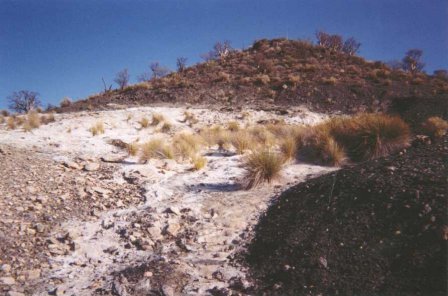
Arroyo El Volcan
Here is the road coming from El Marmol (on the left), crosses Arroyo el Volcan, and passes the white mineralized slope of tiny springs, as seen below
http://maps.google.com/maps?ll=29.997375,-114.767261&spn...
This is incredible!
[Edited on 5-15-2005 by David K]
|
|
|
David K
Honored Nomad
Posts: 64490
Registered: 8-30-2002
Location: San Diego County
Member Is Offline
Mood: Have Baja Fever
|
|
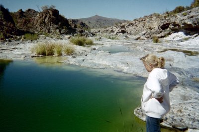
El Volcan Onyx Dome
In the center, the round white area in the arroyo... this is just south of the place where the road from El Marmol crosses the arroyo (in above photo)
El Volcan
On the page that comes up with the image, click: 'Link to This Page' and the image gets bigger. If you scroll to a new site, and want to save it...
just hit Link to This Page again, and the URL in your browser will be the right one. Paste that into Baja Nomad's links feature (the globe with the
chain in front) to add more Baja places to this thread's list.
Here is the dome from the ground:
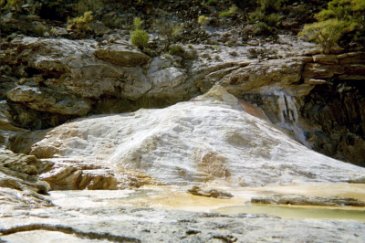
Also in the satellite image, you can see the pool of water north of the dome...
[Edited on 5-15-2005 by David K]
|
|
|
turtleandtoad
Senior Nomad
Posts: 730
Registered: 1-20-2005
Location: Wherever I park. See sig for current location.
Member Is Offline
Mood: Good if fishing
|
|
Yeah, but can you get close enough to find the Topes?
When I try to zoom in on the Playa Requeson area it says that it can't do it. Bummer.
Mike & Robin; Full-Time RV\'ers
37\' Georgetown w/3 slides & 275 Watts of Solar Power
06 Taco TRD
www.turtleandtoad.com
I am here
To paraphrase Frank Lloyd Wright; I\'m all in favor of keeping dangerous weapons out of the hands of fools. Let\'s start with keyboards. --
Mike Dean |
|
|
Bajabus
Senior Nomad
Posts: 892
Registered: 8-30-2002
Location: Elias Calles B.C.S. or NC USA
Member Is Offline
Mood: My friends..it's good.
|
|
It's Satmex 5 that has coverage all the way down to the tip on a direcway unit, NOT satmex 7.
Only datastorm users can request satellite changes depending on which part of the country you are traveling. You are allowed 1 free per year and then
it's $50 each after that.
Tripod mounted DW users don't have that option unless they bought from a very good dealer that is willing to go to bat for you and at most they will
do it once with some sort of excuse like my neighbor built a barn and now my line of sight is blocked. This is because Tripod DW users are not really
supposed to be moving their systems and they are supposed to be fixed.
Starband tripod systems are authorized to be mobile. If you use Starband you won't have to worry about which sat you are assigned to. You will be
put on IA-7 which offers coverage in all of the USA a good way into mainland Mexico, Down to Mulege on the Baja peninsula and about 50 - 100 miles
into Canada with the standard antenna.
Take a look at the Ku band footprint here:
http://www.geo-orbit.org/westhemipgs/ft7p.html
The standard antenna will give you INTERNET connectivity just about anywhere within the 44 db line. A .98 meter antenna will take you out to the 42 db
line and a 1.2 meter will pretty much keep you connected anywhere within the 40 db line. Now take all of this with a grain of salt since the map is
meant to give you a general idea. It kinda reads just like a topo map especially where the lines are close together. At these points the cliff effect
comes into play and the signal will drop off very rapidly. As you approach the outer limits of your antennas performance in a particular location you
will notice that at night you will stay connected fine but as soon as 10AM to about 6 PM roll around you will get disconnected because your signal
will not be strong enough to over come the background solar noise.
A tripod unit with a .98 meter antenna will take you all over Baja. It will run you well under $1,400 with the .98mt. as opposed to about $5,000
(installed) for the auto pointing Datastorm units.
Tripod units take about 30 mins to set up and come with 50 -100 ft of cable so you don't have to worry about parking under trees and not having LOS
with your motor home automatic unit since you can spool out cable and put the tripos where it has LOS and your vehicle in the shade.
Auto pointing units are very convenient in that you just push a button and 5-10 mins later are online.
"Preventive war was an invention of Hitler. Frankly I would not even listen to anyone seriously that came and talked of such a thing."
Dwight David Eisenhower
|
|
|
Barry A.
Select Nomad
Posts: 10007
Registered: 11-30-2003
Location: Redding, Northern CA
Member Is Offline
Mood: optimistic
|
|
these are incredible, David. Thank you !!!!!
|
|
|
| Pages:
1
2 |


