| Pages:
1
2 |
PaulW
Ultra Nomad

Posts: 3005
Registered: 5-21-2013
Member Is Offline
|
|
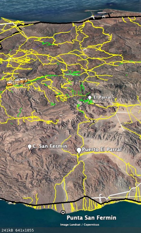
Puerto el Parral
On the Almanac and the Baja Atlas "Puerto el Parral" is shown at the junction of the Las Blancas drainage and Arroyo Matomi. Parral drainage is a long
way from the place.
So what is the meaning or history of that place on the map?
|
|
|
mtgoat666
Select Nomad
Posts: 17302
Registered: 9-16-2006
Location: San Diego
Member Is Offline
Mood: Hot n spicy
|
|
In this case puerto likely means pass.
Unlike DK, i dont think someone in DF made up the name on a whim.
Woke!
“...ask not what your country can do for you – ask what you can do for your country.” “My fellow citizens of the world: ask not what America
will do for you, but what together we can do for the freedom of man.”
Prefered gender pronoun: the royal we
|
|
|
PaulW
Ultra Nomad
Posts: 3005
Registered: 5-21-2013
Member Is Offline
|
|
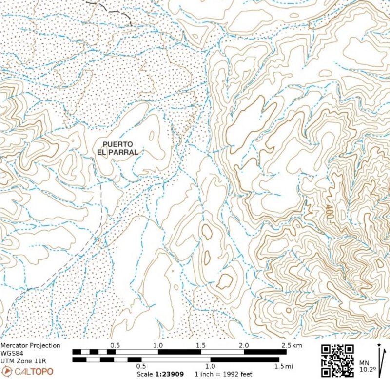
Does not show on caltopo and I am to lazy to see it it appears on older INEGI maps.
Huh - the pass to the vines or grapes???
Quite a stretch to place that label at the entrance to the Cinnamon or Canelo valley.
So I suppose coming from the east to get to the Parrals then a label is needed.
|
|
|
David K
Honored Nomad
Posts: 64480
Registered: 8-30-2002
Location: San Diego County
Member Is Offline
Mood: Have Baja Fever
|
|
Quote: Originally posted by PaulW  | Does not show on caltopo and I am to lazy to see it it appears on older INEGI maps.
Huh - the pass to the vines or grapes???
Quite a stretch to place that label at the entrance to the Cinnamon or Canelo valley.
So I suppose coming from the east to get to the Parrals then a label is needed. |
It indeed does show on the topo map. Zoom in, the label is not over the pass... Just more sloppy D.F. cartography.
[Edited on 5-20-2022 by David K]
|
|
|
mtgoat666
Select Nomad
Posts: 17302
Registered: 9-16-2006
Location: San Diego
Member Is Offline
Mood: Hot n spicy
|
|
| Quote: Originally posted by David K | | Quote: Originally posted by PaulW | Does not show on caltopo and I am to lazy to see it it appears on older INEGI maps.
Huh - the pass to the vines or grapes???
Quite a stretch to place that label at the entrance to the Cinnamon or Canelo valley.
So I suppose coming from the east to get to the Parrals then a label is needed. |
It indeed does show on the topo map. Zoom in, the label is not over the pass... Just more sloppy D.F. cartography.
|
Not sloppy. Label placement is correct. Cartographic convention for a geographic feature like this is to place label to upper right of feature. Think
about how silly it would be if the label were over the feature and obscuring the detail. Cartography uses standard conventions for labels, which makes
map reading easier.
DF people know their chit. DK, you should get a book on cartography techniques.
[Edited on 5-20-2022 by mtgoat666]
Woke!
“...ask not what your country can do for you – ask what you can do for your country.” “My fellow citizens of the world: ask not what America
will do for you, but what together we can do for the freedom of man.”
Prefered gender pronoun: the royal we
|
|
|
4x4abc
Ultra Nomad
Posts: 4163
Registered: 4-24-2009
Location: La Paz, BCS
Member Is Offline
Mood: happy - always
|
|
| Quote: Originally posted by PaulW | Does not show on caltopo and I am to lazy to see it it appears on older INEGI maps.
Huh - the pass to the vines or grapes???
Quite a stretch to place that label at the entrance to the Cinnamon or Canelo valley.
So I suppose coming from the east to get to the Parrals then a label is needed. |
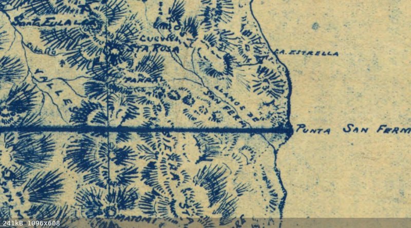
CalTopo:

Harald Pietschmann
|
|
|
PaulW
Ultra Nomad
Posts: 3005
Registered: 5-21-2013
Member Is Offline
|
|
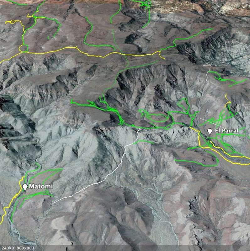
Sure enough I was looking closer to Matomi
Goat maybe. On the same image see the label for Picacho el Canelo where the label is upper left. It does not cover up the summit topo lines.
Looks like the cartographer just placed Puerto el Parral in a clear flat place where there are no topo lines. Thus it is not evident where the Puerto
is really located. Probably not a meaningful place for the label unless it refers to the valley of Canelo?
|
|
|
mtgoat666
Select Nomad
Posts: 17302
Registered: 9-16-2006
Location: San Diego
Member Is Offline
Mood: Hot n spicy
|
|
| Quote: Originally posted by PaulW | Sure enough I was looking closer to Matomi
Goat maybe. On the same image see the label for Picacho el Canelo where the label is upper left. It does not cover up the summit topo lines.
Looks like the cartographer just placed Puerto el Parral in a clear flat place where there are no topo lines. Thus it is not evident where the Puerto
is really located. Probably not a meaningful place for the label unless it refers to the valley of Canelo? |
Very evident where pass is.
The E in “EL” is just 100 yards to right of the pass. Trail/road goes n-s thru this pass. There is a bldg or tank just north of pass — see ge
image.
Topo lines indicate a pass.
Label is to upper right of topo feature, the way it should be on map.
Map could not be any more clear!
Woke!
“...ask not what your country can do for you – ask what you can do for your country.” “My fellow citizens of the world: ask not what America
will do for you, but what together we can do for the freedom of man.”
Prefered gender pronoun: the royal we
|
|
|
David K
Honored Nomad
Posts: 64480
Registered: 8-30-2002
Location: San Diego County
Member Is Offline
Mood: Have Baja Fever
|
|
The original question from Paul was asking about the meaning or history of that name on the Benchmark and Almanac maps...
I tried to provide an answer that also included a reason why El Parral was applied to the "Puerto" there, so far from the original El Parral (ranch,
canyon, arroyo), north of Matomí ranch/ canyon.
Just not a lot of originality with these INEGI folks... The name Parral was also used for the pass between the sulfur mine area and Valle Chico! That
again was a simple lack of new names to pick from...
Nobody lives around there to provide there own name, either.
Cañon el Parral is applied to both the original (true) canyon in the San Pedro Mártir and to the pass going from Valle Chico across to the old
Puertecitos road.
SCORE called it Azufre Wash and Bruce Barber called it Crazy Horse Canyon. I first called it Santa Rosa Canyon in 1978 when I found it and drove
through. Maps I had then had called the low range mountain Sierra Santa Rosa.
So, Parral is the name that comes from the canyon with wild grape vines (north of Rancho Matomí) and got applied to all sorts of places for many
miles around!
The 1969 Auto Club Map (Sierra Santa Rosa) showing the Canelo and Matomí arroyo junction (no name) that is near the Puerto El Parral label on INEGI
maps:

|
|
|
4x4abc
Ultra Nomad
Posts: 4163
Registered: 4-24-2009
Location: La Paz, BCS
Member Is Offline
Mood: happy - always
|
|
for David INEGI is like the US liberals
once identified as bad, they are bad forever
I think the INEGI people know the business of map making well
they have seen more old and local maps than any of us ever has
mistakes?
sure - we all make them
good for INEGI is that they constantly edit/correct/update their maps
the highly praised Baja Almanac is entirely based on INEGI material
Harald Pietschmann
|
|
|
4x4abc
Ultra Nomad
Posts: 4163
Registered: 4-24-2009
Location: La Paz, BCS
Member Is Offline
Mood: happy - always
|
|
Puerto el Parral may have been an important waypoint during times of bad maps and bad trails
we have to see this in context
in the old days a map was some scribble on a napkin
they were always accompanied by verbal directions
"turn right at the red cliff" etc
El Parral was one of the major points to cross the sierra
to travel between Ensenada (a place of supplies and communication) and the mines on the east shore
El Parral was important because it is one of the few points with reliable water
San Fermin was one of the major map points when traveling east
there are about 50 Puertos and Puertas indicating a gateway on a major trail
a point that should not be missed or lose the trail direction
I believe Puerto El Parral was one of those important points
right at the confluence of Arroyo San Fermin and Arroyo Matomi
one needed to follow Arroyo Matomi
since copying the exact location from old maps into new maps is very difficult without local knowledge, Puerto El Parral is likely a bit off
I think it should be at: 30.494469°, -114.830899°
right at the mouth of the Matomi narrows
one mountain peak in the area also played an important rule
remember - important points were the ones visible for someone on foot
helping to keep one's bearings
the important peak in the area was called Rugged Peak in old maps
later Cerro San Fermin - replaced today by Cerro Los Heme
it is visible throughout most your travel from the mountains above El Parral to Punta San Fermin
Picacho Canelo was added in later maps as an additional reference
Harald Pietschmann
|
|
|
4x4abc
Ultra Nomad
Posts: 4163
Registered: 4-24-2009
Location: La Paz, BCS
Member Is Offline
Mood: happy - always
|
|
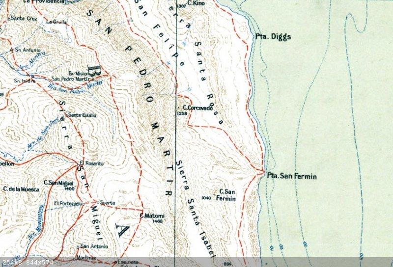
the above image is from the 1925 Goldbaum map
below another map showing (kinda) the route to San Fermin
it includes Rugged Peak (Cerro San Fermin)
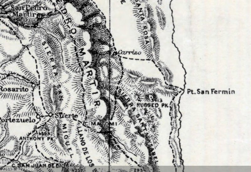
Harald Pietschmann
|
|
|
4x4abc
Ultra Nomad
Posts: 4163
Registered: 4-24-2009
Location: La Paz, BCS
Member Is Offline
Mood: happy - always
|
|
the first halfway accurate maps were in 1923 by the US military and followed by Gulick and McMahan in the 1950's
unfortunately Gulick did not add the El Parral trail details to his maps
well, that was not the focus of his work
1923-1928--Baja-California--Mexico--US-Army-Maps-Merged--fromUWM.jpeg
Harald Pietschmann
|
|
|
4x4abc
Ultra Nomad
Posts: 4163
Registered: 4-24-2009
Location: La Paz, BCS
Member Is Offline
Mood: happy - always
|
|
notice the pattern of roads and trails between San Quintin and Punta San Fermin
almost a straight line
Harald Pietschmann
|
|
|
4x4abc
Ultra Nomad
Posts: 4163
Registered: 4-24-2009
Location: La Paz, BCS
Member Is Offline
Mood: happy - always
|
|
I have been working on the trails crossing into Matomi and El Parral for some time
definitely a high traffic area in the old days
Harald Pietschmann
|
|
|
mtgoat666
Select Nomad
Posts: 17302
Registered: 9-16-2006
Location: San Diego
Member Is Offline
Mood: Hot n spicy
|
|
The pass is at correct location on maps. You can even see on GE someone built a structure just to north side of the pass, and a road or trail going
thru the pass. Must be something about that spot that prompted it to be named…
I trust inegi’s mapping more than arm-chair traveler (internet GE couch surfers) re-interpreting map locations w/o ground-truthing.
[Edited on 5-21-2022 by mtgoat666]
Woke!
“...ask not what your country can do for you – ask what you can do for your country.” “My fellow citizens of the world: ask not what America
will do for you, but what together we can do for the freedom of man.”
Prefered gender pronoun: the royal we
|
|
|
mtgoat666
Select Nomad
Posts: 17302
Registered: 9-16-2006
Location: San Diego
Member Is Offline
Mood: Hot n spicy
|
|
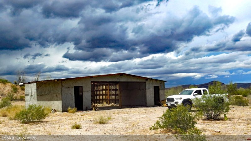
So what is the man-made structure there (visible on GE) at the mapped location of the pass? Post a pic.
[Edited on 5-22-2022 by mtgoat666]
Woke!
“...ask not what your country can do for you – ask what you can do for your country.” “My fellow citizens of the world: ask not what America
will do for you, but what together we can do for the freedom of man.”
Prefered gender pronoun: the royal we
|
|
|
4x4abc
Ultra Nomad
Posts: 4163
Registered: 4-24-2009
Location: La Paz, BCS
Member Is Offline
Mood: happy - always
|
|
knock yourself out
structure at Puerto El Parral
Harald Pietschmann
|
|
|
PaulW
Ultra Nomad
Posts: 3005
Registered: 5-21-2013
Member Is Offline
|
|
Thanks to Harald for meaning full info on the subject.
|
|
|
David K
Honored Nomad
Posts: 64480
Registered: 8-30-2002
Location: San Diego County
Member Is Offline
Mood: Have Baja Fever
|
|
Ancient Obsidian from Puerto el Parral (mentioned in this paper by Lee Panich): https://www.academia.edu/19652471/Exploring_Patterns_of_Obsi...
|
|
|
| Pages:
1
2 |


