David K
Honored Nomad

Posts: 65106
Registered: 8-30-2002
Location: San Diego County
Member Is Offline
Mood: Have Baja Fever
|
|
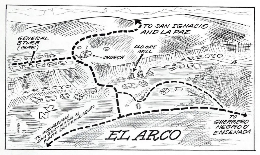
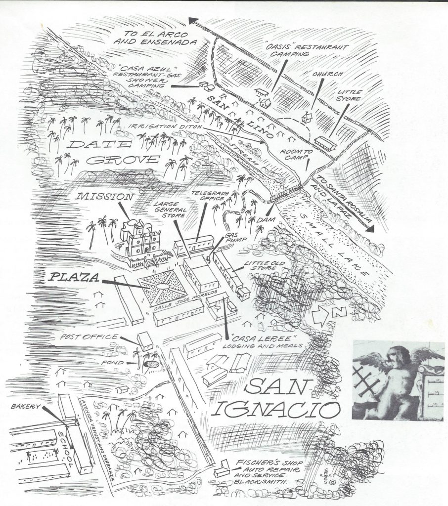
The 1970-72 Cliff Cross Maps, now bigger!
Cliff Cross, authored a very popular Baja guidebook in 1970. He had an updated edition in 1972 and again in 1974. The 1973 edition was mostly a
reprint of the 1972 edition.
Cliff's maps were great fun, because many were drawn with a bird's-eye-view style that anyone could understand.
I had preserved these 50+ maps earlier, but now, I have increased theri size, making reading them more enjoyable. After the last map are the book
cover images.
Link: https://vivabaja.com/cliff-cross-maps/
Here are a few samples:


|
|
|
KurtG
Super Nomad
Posts: 1211
Registered: 1-27-2004
Location: California Central Coast
Member Is Offline
Mood: Press On Regardless!!
|
|
I have the '73 edition which I bought in '74. I enjoy looking at those maps today to remind me of how the places I have visited over the years
appeared when I first saw them.
|
|
|
4x4abc
Ultra Nomad
Posts: 4404
Registered: 4-24-2009
Location: La Paz, BCS
Member Is Offline
Mood: happy - always
|
|
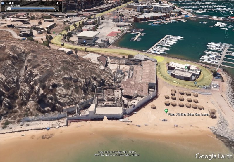
the last image made me look for the main points of that Cabo San Lucas image
Hacienda Hotel is still there (the square)
airport is gone
electric plant is gone
government building is gone (a park now)
fish cannery is gone
the San Lucas Evangelista church is still there (the white marker)
now you also know where Cabo San Lucas got its name

[Edited on 7-19-2022 by 4x4abc]
Harald Pietschmann
|
|
|
David K
Honored Nomad
Posts: 65106
Registered: 8-30-2002
Location: San Diego County
Member Is Offline
Mood: Have Baja Fever
|
|
The Hacienda was on the beach, at the top of the dune hill, and on the opposite side of the dune hill was the mud flat where private planes landed.
That was dredged out to make the marina. We went there in 1966 and again the next trip in '74.
In 2017, the abandoned fish cannery was still there... behind this fence:
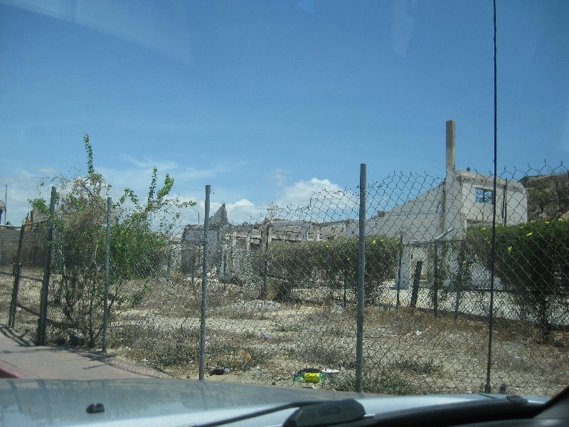
Did they finally tear it all down?
|
|
|
AKgringo
Elite Nomad
Posts: 6132
Registered: 9-20-2014
Location: Anchorage, AK (no mas!)
Member Is Online
Mood: Retireded
|
|
Harald, is the image you posted oriented with "North" at the top?
The random orientation of the Cross maps mess with my mind!
If you are not living on the edge, you are taking up too much space!
"Could do better if he tried!" Report card comments from most of my grade school teachers. Sadly, still true!
|
|
|
David K
Honored Nomad
Posts: 65106
Registered: 8-30-2002
Location: San Diego County
Member Is Offline
Mood: Have Baja Fever
|
|
Quote: Originally posted by AKgringo  | Harald, is the image you posted oriented with "North" at the top?
The random orientation of the Cross maps mess with my mind! |
West, mostly, on Harald's sat image. He tried to match the area shown on Cliff's 1970 map, which points to north, off to the lower right.
|
|
|
4x4abc
Ultra Nomad
Posts: 4404
Registered: 4-24-2009
Location: La Paz, BCS
Member Is Offline
Mood: happy - always
|
|
| Quote: Originally posted by AKgringo | Harald, is the image you posted oriented with "North" at the top?
The random orientation of the Cross maps mess with my mind! |
I aligned my image to the Cross image
Harald Pietschmann
|
|
|
4x4abc
Ultra Nomad
Posts: 4404
Registered: 4-24-2009
Location: La Paz, BCS
Member Is Offline
Mood: happy - always
|
|
| Quote: Originally posted by David K | The Hacienda was on the beach, at the top of the dune hill, and on the opposite side of the dune hill was the mud flat where private planes landed.
That was dredged out to make the marina. We went there in 1966 and again the next trip in '74.
In 2017, the abandoned fish cannery was still there... behind this fence:
Did they finally tear it all down? |
can you point out the cannery on Google?
Harald Pietschmann
|
|
|
David K
Honored Nomad
Posts: 65106
Registered: 8-30-2002
Location: San Diego County
Member Is Offline
Mood: Have Baja Fever
|
|
| Quote: Originally posted by 4x4abc | | Quote: Originally posted by David K | The Hacienda was on the beach, at the top of the dune hill, and on the opposite side of the dune hill was the mud flat where private planes landed.
That was dredged out to make the marina. We went there in 1966 and again the next trip in '74.
In 2017, the abandoned fish cannery was still there... behind this fence:
Did they finally tear it all down? |
can you point out the cannery on Google? |
22° 52.794'N, 109° 54.347'W
Looking west from the bay:
|
|
|


