| Pages:
1
2
3
4 |
Lance S.
Nomad

Posts: 149
Registered: 2-16-2021
Member Is Offline
|
|
Del Barco on the Sierra La Asamblea / De Jubai
From Miguel Del Barco's chapter on Calamajue:
"padeciendo la misma falta las bestias de la misión, necesarias
así para que los padres salieran a las confesiones de enfermos muy dis-
tantes, como para el acarreo de víveres y de cuanto era menester, por lo
menos desde San Borja. Había el padre Linck dado a estos padres un
poco de ganado menor, para algún alivio en sus trabajos; mas a poco tiem-
po, consumido lo que tenía que comer en el arroyo, se hallaba en la mis-
ma necesidad que la caballada. Registraron la inmediata sierra de Jubai,
que es alta, y la subida es difícil, arenosa y sin descanso. Hallaron en su
cima dos pequeños manantiales de muy buena agua, pero en sitios en que
no podían tener otro uso que apagar la sed. Hay en esas alturas muchas
y muy altas palmas y algunos pinos; mas las pequeñas llanuras que hay
en este paraje están como las laderas de la sierra, desnudas de pasto, a
excepción de las cercanías de los aguajes, en que habían algunas yerbas.
Enviaron los padres a esta sierra el ganado menor para que lograran aquel
poco alimento cercano a los aguajes; mas habiendo estado allí un solo día,
volvió muy disminuido, habiendo muerte no poco de frío"
Maybe here, appears to have water at least seasonally
29°22'08"N 114°04'52"W
[Edited on 8-7-2022 by Lance S.]
|
|
|
David K
Honored Nomad
Posts: 64478
Registered: 8-30-2002
Location: San Diego County
Member Is Offline
Mood: Have Baja Fever
|
|
For the English only readers, can you provide a better translation?
Tinaja de Yubay is a major water source north of San Borja.
It is a tank that holds rain or flash flood water for long periods.
Unfortunately, Google isn't a Native speaker!:
"Suffering from the same lack the beasts of the mission, necessary
so that the parents would go out to the confessions of very different patients.
Enough, as for the transport of food and whatever was necessary, so
less from San Borja.
Had Father Linck given these parents a little small cattle, for some relief in their work; but little time little, consumed what he had to eat in the
stream, was in the same necessity than the cavalry.
They searched the immediate Jubai [Yubay] mountain range,
which is high, and the climb is difficult, sandy and without rest.
They found in his top two small springs with very good water, but in places where they could have no other use than to quench thirst.
There are in those heights many and very tall palms and some pines; but the small plains that there are in this place they are like the slopes of the
mountains, bare of grass, except for the vicinity of the aguajes [water sources], where there were some herbs.
The padres sent their small cattle to this mountain range so that they could achieve that little food near the aguajes; but having been there a single
day,
he returned greatly diminished, having died not a little from the cold"
[Edited on 4-2-2024 by David K]
|
|
|
Lance S.
Nomad
Posts: 149
Registered: 2-16-2021
Member Is Offline
|
|
The jesuits refered to the Sierra La Asamblea as the Sierra De Jubai. See Clavigero's chapter on Calamajue, I believe it's on the first page.
Basically they tried to keep one small head of cattle at Calamajue to use as a work animal but it quickly ate the available grass. They explored the
heights of the Sierra De Jubai and found the small "plains" to be desolate except in the vicinity of two small aquajes. They took the small
malnourished beast all the way up there but it died after one day "due in no small part to the cold".
[Edited on 8-7-2022 by Lance S.]
|
|
|
David K
Honored Nomad
Posts: 64478
Registered: 8-30-2002
Location: San Diego County
Member Is Offline
Mood: Have Baja Fever
|
|
Yes, thanks... named after the all-important waterhole (or maybe it was the other way around?).
Keep up the historical subject posts! 
I hiked to the Tinaja de Yubay in 2001 (it was very low). Neal Johns went there in 2003, and it was overflowing! See his photos: https://vivabaja.com/neal2/
|
|
|
David K
Honored Nomad
Posts: 64478
Registered: 8-30-2002
Location: San Diego County
Member Is Offline
Mood: Have Baja Fever
|
|
Thanks, Lencho!
|
|
|
Lance S.
Nomad
Posts: 149
Registered: 2-16-2021
Member Is Offline
|
|
Is this Cerro la Asamblea? 29°22'04"N 114°05'23"W
It is adjacent to that cool little pocket meadow ( 29°22'08"N 114°04'52"W) that could be the place Del Barco was talking about.
https://www.researchgate.net/figure/Maps-of-the-Sierra-La-As...
[Edited on 8-7-2022 by Lance S.]
|
|
|
Lance S.
Nomad
Posts: 149
Registered: 2-16-2021
Member Is Offline
|
|
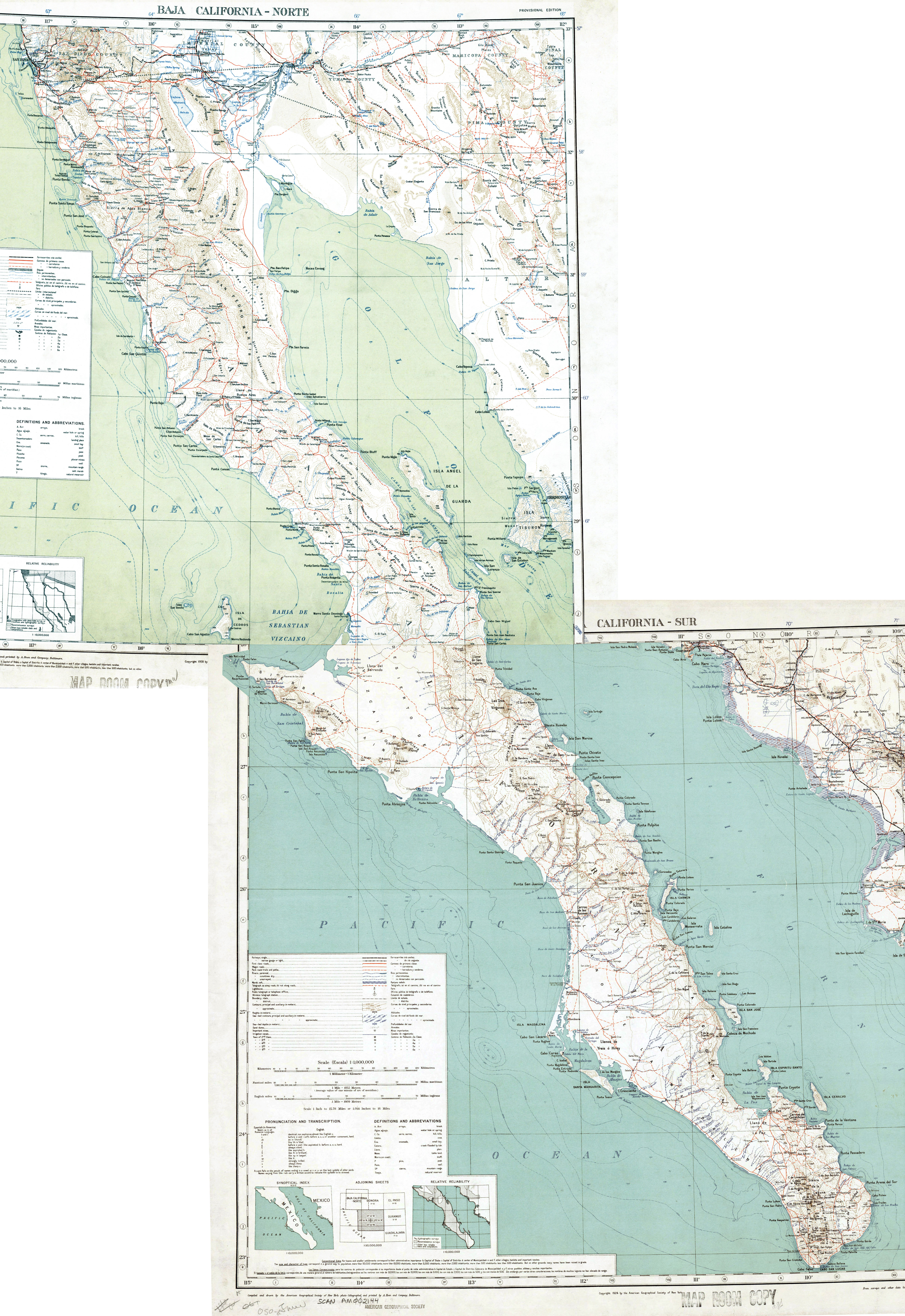
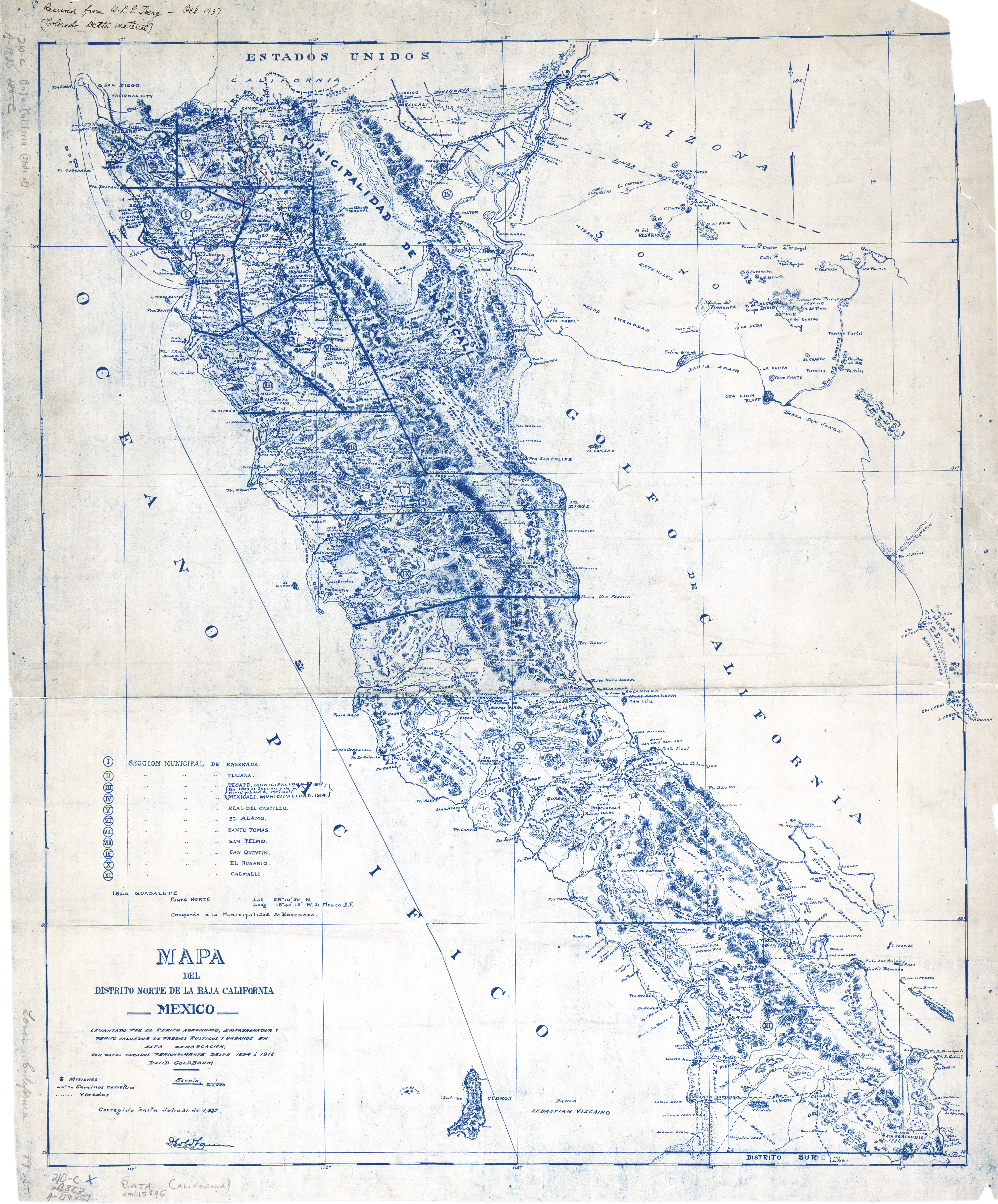
On the Goldbaum map there is a trail from Calamajue to a location marked Asamblea. Perhaps this is the water mentioned by Del Barco? Next to Cerro
la Asamblea?
https://collections.lib.uwm.edu/digital/collection/agdm/id/3...
The route shown from Calamajue to Asamblea could be pretty much the same one taken by the people in Del Barco's account.
The location also appears on this one
https://octopup.org/img/misc/forums/bajanomad/maps/1923-1928...
[Edited on 8-7-2022 by Lance S.]
|
|
|
David K
Honored Nomad
Posts: 64478
Registered: 8-30-2002
Location: San Diego County
Member Is Offline
Mood: Have Baja Fever
|
|
Lance, I have these maps on VivaBaja.com and you can zoom in closer than the Nomad linked one. Octopup ('geoffff') made them for VivaBaja as well.
All maps on VivaBaja: https://vivabaja.com/maps/
1918 David Goldbaum Baja California Norte Map (printed in 1925): https://octopup.org/img/media/maps/baja/1925--Baja-Californi...
1923 & 1928 Baja California Geographical Maps: https://octopup.org/img/misc/forums/bajanomad/maps/1923-1928...
|
|
|
Lance S.
Nomad
Posts: 149
Registered: 2-16-2021
Member Is Offline
|
|
Thank you David.
The name Asamblea is an interesting one. There is a theme common in yuman mythology where the culture hero assembles the people somewhere to teach
them something . The romantic in me likes to believe that Cerro Asamblea, the highest point in the sierra, is one of those places.
The pinyon forest would also have made the water source up there ( wherever it is) a place of assembly. Pinyon are harvested from the late summer
into fall so that water would have to be perennial for that to be the case.
Asamblea could also have Christian significance, synonymous with congregation.
[Edited on 8-10-2022 by Lance S.]
|
|
|
Lance S.
Nomad
Posts: 149
Registered: 2-16-2021
Member Is Offline
|
|
Oddly, not to long after founding San Borja Linck is told about a place of assembly two days to the north. Tinaja Jubai was two days north of San
Borja.
[Edited on 8-10-2022 by Lance S.]
|
|
|
David K
Honored Nomad
Posts: 64478
Registered: 8-30-2002
Location: San Diego County
Member Is Offline
Mood: Have Baja Fever
|
|
Keep up the good research, Lance.
Wouldn't it be fun to go to the top of Asamblea and maybe see where the pinyon trees were cut by the Spaniards? They had only enough wood to make one
door for the new mission at Calamajué.
On a similar subject, here are the güéríbo trees cut in 1719 to build Ugarte's ship, El Triunfo de la Cruz: https://www.dstretch.com/CNPSGueribo/
|
|
|
4x4abc
Ultra Nomad
Posts: 4163
Registered: 4-24-2009
Location: La Paz, BCS
Member Is Offline
Mood: happy - always
|
|
Quote: Originally posted by Lance S.  | Thank you David.
The name Asamblea is an interesting one. There is a theme common in yuman mythology where the culture hero assembles the people somewhere to teach
them something . The romantic in me likes to believe that Cerro Asamblea, the highest point in the sierra, is one of those places.
The pinyon forest would also have made the water source up there ( wherever it is) a place of assembly. Pinyon are harvested from the late summer
into fall so that water would have to be perennial for that to be the case.
Asamblea could also have Christian significance, synonymous with congregation.
[Edited on 8-10-2022 by Lance S.] |
no Cerro Asamblea in all of Baja California
Sierra La Asamblea - yes
Harald Pietschmann
|
|
|
4x4abc
Ultra Nomad
Posts: 4163
Registered: 4-24-2009
Location: La Paz, BCS
Member Is Offline
Mood: happy - always
|
|
the 2 springs mentioned are at Rancho San Luis (why Sierra La Asamblea is also called Sierra San Luis)
29.276251°, -114.048566°
no pine forest around there
Harald Pietschmann
|
|
|
4x4abc
Ultra Nomad
Posts: 4163
Registered: 4-24-2009
Location: La Paz, BCS
Member Is Offline
Mood: happy - always
|
|
I have traced 3 distinct trails recorded leading to the San Luis springs
29.289429°, -114.115773°
29.279381°, -114.100723°
29.277524°, -114.097636°
all start around Mina Placer de Cota
and then there is the easy route from the south (Yubay)
Harald Pietschmann
|
|
|
4x4abc
Ultra Nomad
Posts: 4163
Registered: 4-24-2009
Location: La Paz, BCS
Member Is Offline
Mood: happy - always
|
|
a longer, steeper and tougher route is visible through Arroyo Las Palmas
29.344188°, -114.118156°
the road to the hunting camp is still drivable
29.346221°, -114.150139°
Harald Pietschmann
|
|
|
David K
Honored Nomad
Posts: 64478
Registered: 8-30-2002
Location: San Diego County
Member Is Offline
Mood: Have Baja Fever
|
|
| Quote: Originally posted by 4x4abc | the 2 springs mentioned are at Rancho San Luis (why Sierra La Asamblea is also called Sierra San Luis)
29.276251°, -114.048566°
no pine forest around there |
Look a few miles north of Rancho San Luis... Higher in elevation, lot's of green trees and this little grassy meadow:
29.368999°, -114.081412°
|
|
|
AKgringo
Elite Nomad
Posts: 5805
Registered: 9-20-2014
Location: Anchorage, AK (no mas!)
Member Is Offline
Mood: Retireded
|
|
| Quote: Originally posted by 4x4abc | the 2 springs mentioned are at Rancho San Luis (why Sierra La Asamblea is also called Sierra San Luis)
29.276251°, -114.048566°
no pine forest around there |
I was not aware that Pinyon Pines grew in Baja, but if they do, they would be more a shrub patch than a forest of trees.
If you are not living on the edge, you are taking up too much space!
"Could do better if he tried!" Report card comments from most of my grade school teachers. Sadly, still true!
|
|
|
4x4abc
Ultra Nomad
Posts: 4163
Registered: 4-24-2009
Location: La Paz, BCS
Member Is Offline
Mood: happy - always
|
|
| Quote: Originally posted by David K | | Quote: Originally posted by 4x4abc | the 2 springs mentioned are at Rancho San Luis (why Sierra La Asamblea is also called Sierra San Luis)
29.276251°, -114.048566°
no pine forest around there |
Look a few miles north of Rancho San Luis... Higher in elevation, lot's of green trees and this little grassy meadow:
29.368999°, -114.081412° |
yes, that is one of the trail intersections coming up from Arroyo Las Palmas, connecting to San Luis (8 miles away) - well established trail
there is an area along the trail that likely has water
Palm trees are present
29.362611°, -114.083972°
[Edited on 8-11-2022 by 4x4abc]
Harald Pietschmann
|
|
|
David K
Honored Nomad
Posts: 64478
Registered: 8-30-2002
Location: San Diego County
Member Is Offline
Mood: Have Baja Fever
|
|
| Quote: Originally posted by AKgringo | | Quote: Originally posted by 4x4abc | the 2 springs mentioned are at Rancho San Luis (why Sierra La Asamblea is also called Sierra San Luis)
29.276251°, -114.048566°
no pine forest around there |
I was not aware that Pinyon Pines grew in Baja, but if they do, they would be more a shrub patch than a forest of trees. |
There is even a distinct Pinyon Pine (Pinus lagunae) native to the Sierra la Laguna, south of La Paz... page 59-60 of...
|
|
|
Lance S.
Nomad
Posts: 149
Registered: 2-16-2021
Member Is Offline
|
|
Single leaf pinyon, they grow pretty densely on some of the east and north facing slopes near the top of the Sierra La Asamblea. It's a sky island
with disjunct species from farther north.
[Edited on 8-11-2022 by Lance S.]
|
|
|
| Pages:
1
2
3
4 |


