| Pages:
1
2
3
4 |
Lance S.
Nomad

Posts: 149
Registered: 2-16-2021
Member Is Offline
|
|
https://www.researchgate.net/figure/Average-spectral-signatu...
|
|
|
Lance S.
Nomad
Posts: 149
Registered: 2-16-2021
Member Is Offline
|
|
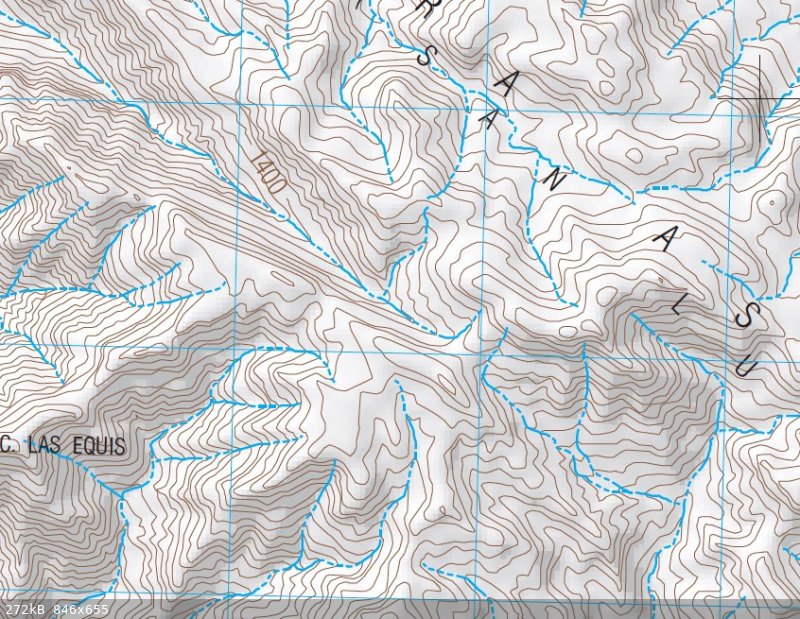
Canyon Las Equis
29°22'13"N 114°06'18"W
[Edited on 9-16-2022 by Lance S.]
|
|
|
Lance S.
Nomad
Posts: 149
Registered: 2-16-2021
Member Is Offline
|
|
Cross over the rise immediately south of the meadow and you are in the head of Arroyo Asamblea. You can then follow it and its palm groves to the
gulf. That must be the section on the Goldbaum map between Asamblea and Pozo Solorio.
[Edited on 8-13-2022 by Lance S.]
|
|
|
David K
Honored Nomad
Posts: 64480
Registered: 8-30-2002
Location: San Diego County
Member Is Offline
Mood: Have Baja Fever
|
|
He didn't write about pinyon pines, but Erle Stanly Gardner was enthralled with the area! He wrote a book in 1961 about the canyons north of L.A.
Bay...

|
|
|
4x4abc
Ultra Nomad
Posts: 4163
Registered: 4-24-2009
Location: La Paz, BCS
Member Is Offline
Mood: happy - always
|
|
cool paper
Harald Pietschmann
|
|
|
Lance S.
Nomad
Posts: 149
Registered: 2-16-2021
Member Is Offline
|
|
Glad you liked it. Here is a similar paper that comes to mind in case you haven't seen it.
https://www.researchgate.net/figure/Distributions-of-native-...
|
|
|
4x4abc
Ultra Nomad
Posts: 4163
Registered: 4-24-2009
Location: La Paz, BCS
Member Is Offline
Mood: happy - always
|
|
Quote: Originally posted by Lance S.  | Is this Cerro la Asamblea? 29°22'04"N 114°05'23"W
It is adjacent to that cool little pocket meadow ( 29°22'08"N 114°04'52"W) that could be the place Del Barco was talking about.
|
I call it Cerro La Asamblea
it is the highest peak in the area
INEGI did not name it on any of its maps
Harald Pietschmann
|
|
|
4x4abc
Ultra Nomad
Posts: 4163
Registered: 4-24-2009
Location: La Paz, BCS
Member Is Offline
Mood: happy - always
|
|
'
yeah, I saw that paper some time ago.
I have identified quite a number of Phoenix locations by now.
Better resolution GE images have really helped to identify them
They are usually tied to missionary activity - but early 1800's settlers also planted Phoenix.
They need a lot of care and don't easily seed themselves.
Only the old-timers were willing to do that
Harald Pietschmann
|
|
|
David K
Honored Nomad
Posts: 64480
Registered: 8-30-2002
Location: San Diego County
Member Is Offline
Mood: Have Baja Fever
|
|
From a paper, midway down many papers on geology and biology of Baja and the gulf:
https://www.academia.edu/15521074/Baja_California_oases_a_hi...
DISTRIBUTION OF CHAPARRAL AND PINE-OAK “SKY ISLANDS” IN CENTRAL AND SOUTHERN BAJA CALIFORNIA AND IMPLICATIONS OF PACK RAT MIDDEN RECORDS ON
CLIMATE CHANGE SINCE THE LAST GLACIAL MAXIMUM


FIGURE 3A (ABOVE).
Chaparral on Cerro San Luis in the Sierra La Asamblea.
Adenostoma fasciculatum
(chamise) in the foreground growing with taller
Pinus monophylla
. The Gulf of California is in the distance (photo courtesy of K. Geraghty).
FIGURE 3B (BELOW).
Resistant bedrock granite slope with
Quercus chrysolepis
,
Pinus monophylla
, and
Brahea armata
on the Sierra La Asamblea plateau (photo courtesy of K. Geraghty).
[Edited on 8-12-2022 by David K]
|
|
|
mtgoat666
Select Nomad
Posts: 17295
Registered: 9-16-2006
Location: San Diego
Member Is Offline
Mood: Hot n spicy
|
|
| Quote: Originally posted by David K | From a paper, midway down many papers on geology and biology of Baja and the gulf:
https://www.academia.edu/15521074/Baja_California_oases_a_hi...
DISTRIBUTION OF CHAPARRAL AND PINE-OAK “SKY ISLANDS” IN CENTRAL AND SOUTHERN BAJA CALIFORNIA AND IMPLICATIONS OF PACK RAT MIDDEN RECORDS ON
CLIMATE CHANGE SINCE THE LAST GLACIAL MAXIMUM
FIGURE 3A (ABOVE).
Chaparral on Cerro San Luis in the Sierra La Asamblea.
Adenostoma fasciculatum
(chamise) in the foreground growing with taller
Pinus monophylla
. The Gulf of California is in the distance (photo courtesy of K. Geraghty).
FIGURE 3B (BELOW).
Resistant bedrock granite slope with
Quercus chrysolepis
,
Pinus monophylla
, and
Brahea armata
on the Sierra La Asamblea plateau (photo courtesy of K. Geraghty).
[Edited on 8-12-2022 by David K] |
Pretty typical vegetation zones for baja mountains.
What story did the pack rat middens tell?
Woke!
“...ask not what your country can do for you – ask what you can do for your country.” “My fellow citizens of the world: ask not what America
will do for you, but what together we can do for the freedom of man.”
Prefered gender pronoun: the royal we
|
|
|
David K
Honored Nomad
Posts: 64480
Registered: 8-30-2002
Location: San Diego County
Member Is Offline
Mood: Have Baja Fever
|
|
You can read it for yourself, here: https://www.academia.edu/15521074/Baja_California_oases_a_hi...
|
|
|
4x4abc
Ultra Nomad
Posts: 4163
Registered: 4-24-2009
Location: La Paz, BCS
Member Is Offline
Mood: happy - always
|
|
with every paper comes a new challenge
the challenge to relate the names given by the authors to waterways and peaks
they rarely relate to official (INEGI) names
Cerro San Luis?
a peak close to Rancho San Luis?
Harald Pietschmann
|
|
|
Lance S.
Nomad
Posts: 149
Registered: 2-16-2021
Member Is Offline
|
|
That looks like Mesa Colorado on the right. Maybe Cerro San Luis is another name for Cerro la Asamblea.
[Edited on 8-13-2022 by Lance S.]
|
|
|
Lance S.
Nomad
Posts: 149
Registered: 2-16-2021
Member Is Offline
|
|
| Quote: Originally posted by David K | He didn't write about pinyon pines, but Erle Stanly Gardner was enthralled with the area! He wrote a book in 1961 about the canyons north of L.A.
|
What did he say about aqua buena? Are there photos that might help identify it?
|
|
|
4x4abc
Ultra Nomad
Posts: 4163
Registered: 4-24-2009
Location: La Paz, BCS
Member Is Offline
Mood: happy - always
|
|
| Quote: Originally posted by Lance S. | | Quote: Originally posted by David K | He didn't write about pinyon pines, but Erle Stanly Gardner was enthralled with the area! He wrote a book in 1961 about the canyons north of L.A.
|
What did he say about aqua buena? Are there photos that might help identify it? |
29°22'58.43"N, 113°58'17.45"W
in Arroyo Asamblea
Harald Pietschmann
|
|
|
David K
Honored Nomad
Posts: 64480
Registered: 8-30-2002
Location: San Diego County
Member Is Offline
Mood: Have Baja Fever
|
|
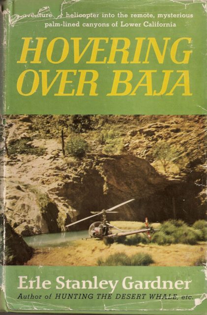
Thank Harald. That looks about right.
Lance, I just flipped through Hovering Over Baja and did not see a mention of the name Agua Buena, except on the map.
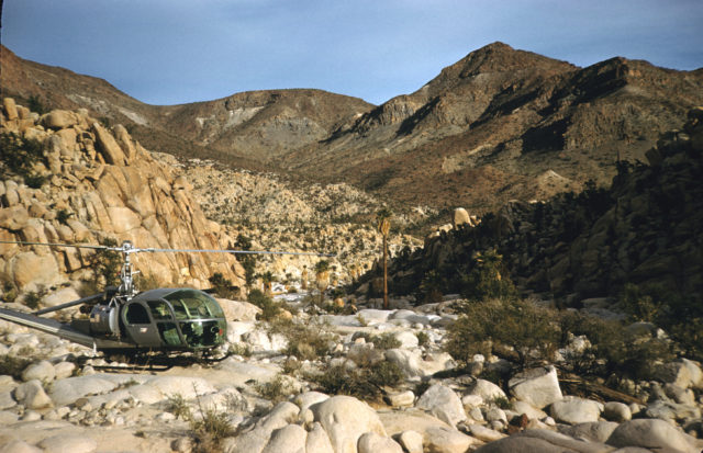
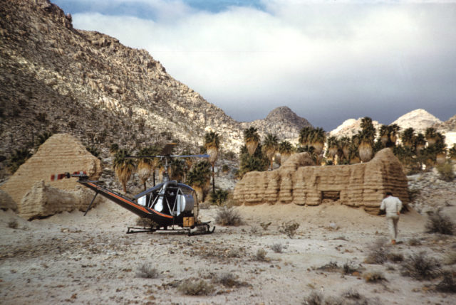
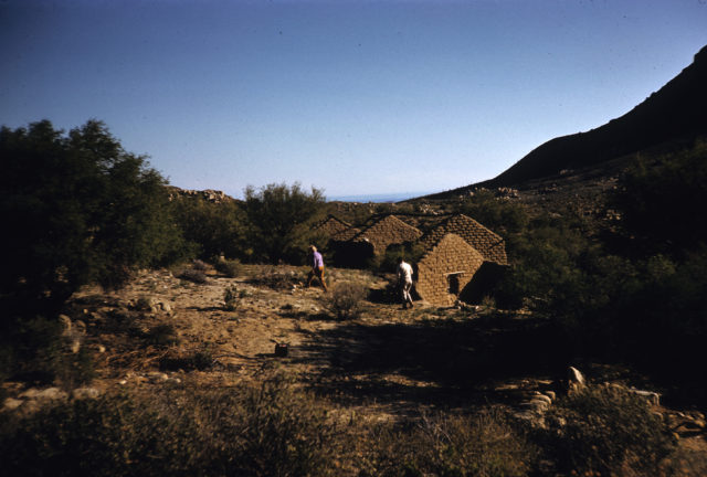
Of course, I may have just missed it... This is one of Gardner's great exploring-adventure books (©1961) and has many references to other places,
like the Hamilton Ranch, the road to Mission Santa María being built, and exploring by helicopter looking for palm canyons and the Lost Mission of
Santa Isabel! I think I will re-read it again soon!
Here are some color photos from Gardner's camera that were possibly from this trip in 1960 (obtained from the Temecula Valley Library):
More at: https://vivabaja.com/esg/
|
|
|
4x4abc
Ultra Nomad
Posts: 4163
Registered: 4-24-2009
Location: La Paz, BCS
Member Is Offline
Mood: happy - always
|
|
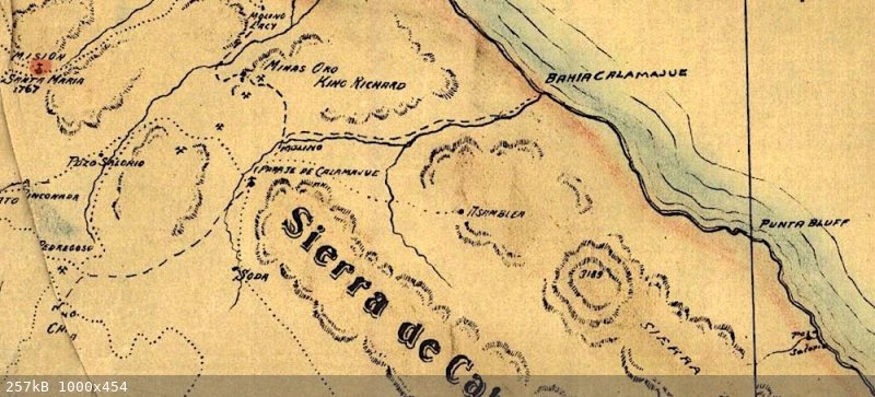
The Goldbaum map is hard to work with. Too many serious mistakes.
Much of it not from personal experience.
Pozo Salorio can not be along the coastline.
There are NO water sources between Aguaje San Juan y San Pablo (Puerto Calamajue) and Bahia de Los Angeles along the coast.
The most likely location of Pozo Salorio is Aguaje Las Palmitas (old Punta Final water source) - also called Calam or Solorrro
Today Pozo Salorio is an archaelogical site way out in the bushes
29°40'0.31"N, 114°39'59.45"W
however, I suspect that the location in given wrong on purpose

Harald Pietschmann
|
|
|
Lance S.
Nomad
Posts: 149
Registered: 2-16-2021
Member Is Offline
|
|
I was thinking maybe it was a batequi.
[Edited on 8-13-2022 by Lance S.]
|
|
|
Lance S.
Nomad
Posts: 149
Registered: 2-16-2021
Member Is Offline
|
|
It is a place where an arroyo meets the sea where you can dig just behind the shore for water at high tide. Fresh water is pushed up by the salt
water. These water holes were typically brackish but drinkable.
[Edited on 8-13-2022 by Lance S.]
[Edited on 8-13-2022 by Lance S.]
|
|
|
4x4abc
Ultra Nomad
Posts: 4163
Registered: 4-24-2009
Location: La Paz, BCS
Member Is Offline
Mood: happy - always
|
|
the 1917 David Golden map shows Pozo Salorio about in the Aguaje Las Palmitas location (far left)
but it also shows it south of Punta Bluff (far right)
Harald Pietschmann
|
|
|
| Pages:
1
2
3
4 |


