StephandBlake
Newbie
Posts: 6
Registered: 9-15-2022
Member Is Offline
|
|
Offline Maps for Hiking and Offroading
Hello. New to BajaNomad!
I am interested in apps for my iPhone/iPad as well as maps I can access on my laptop that show not only roads (including jeep roads) but also names of
geologic features (canyons, streams, peaks, etc.). I am particularly interested in apps that allow downloading maps for use in the field when there
is no internet access. Normally we use Gaia while in the US, but their map of Mexico is not very detailed.
What do you recommend? Thanks!
|
|
|
David K
Honored Nomad

Posts: 64480
Registered: 8-30-2002
Location: San Diego County
Member Is Offline
Mood: Have Baja Fever
|
|
Welcome to Nomad!
Benchmark's Baja California Road & Recreation Atlas' main maps are available to download onto your phone or tablet. With your device's built-in
GPS, the cross-hairs show your location on the map! No cell coverage needed once you load it. You can also record tracks on the map! I used it going
to Mission Santa María, last March. Worked great, see samples of the track below!
Here is the download link on Avenza ($19.99):
https://www.avenzamaps.com/maps/1250162/baja-california-atla...
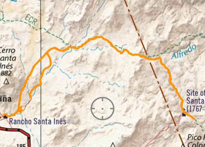
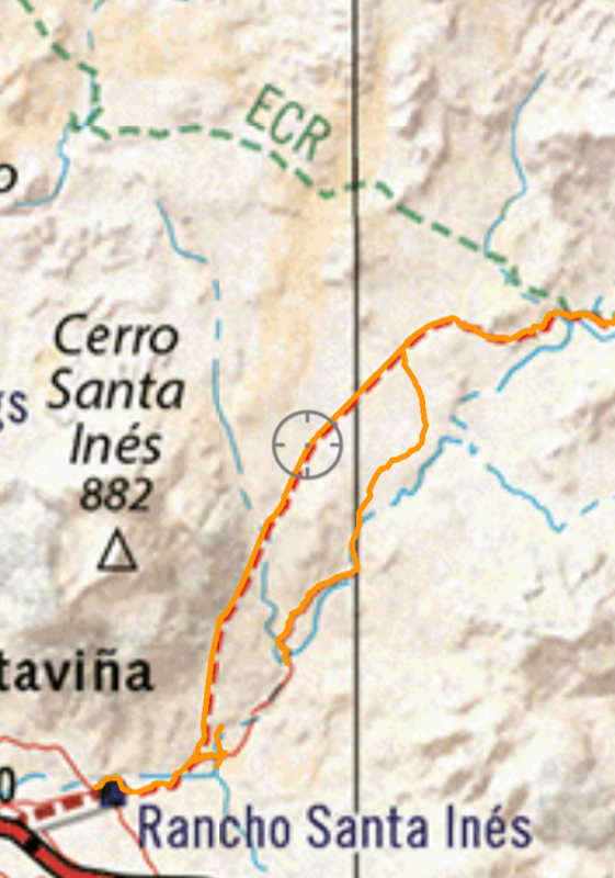
Yes, the El Camino Real is also plotted on the Baja Atlas!
Like Maps of Baja... I have quite a large, online collection you can enjoy: https://vivabaja.com/maps/
[Edited on 9-15-2022 by David K]
|
|
|
gnukid
Ultra Nomad
Posts: 4410
Registered: 7-2-2006
Member Is Offline
|
|
May not be what you want but google maps can be downloaded, you can download the entire region as a local file. You can see trails, everything needed
to navigate out of the brecha.
|
|
|
StephandBlake
Newbie
Posts: 6
Registered: 9-15-2022
Member Is Offline
|
|
Thanks so much, David, for the link. Map's been downloaded. Exactly what I wanted.
|
|
|
4x4abc
Ultra Nomad
Posts: 4163
Registered: 4-24-2009
Location: La Paz, BCS
Member Is Offline
Mood: happy - always
|
|
Quote: Originally posted by StephandBlake  | Hello. New to BajaNomad!
I am interested in apps for my iPhone/iPad as well as maps I can access on my laptop that show not only roads (including jeep roads) but also names of
geologic features (canyons, streams, peaks, etc.). I am particularly interested in apps that allow downloading maps for use in the field when there
is no internet access. Normally we use Gaia while in the US, but their map of Mexico is not very detailed.
What do you recommend? Thanks! |
I am out in the field every week at least once.
Among all apps Gaia GPS with Mexican topo maps (INEGI) is the best
all others are far behind in detail
you need to preload all needed tiles of the topo maps when online
Avenza with Benchmark's Baja California Road & Recreation Atlas is not useful for hiking or details when used on a phone
it is OK for a general overview on the iPad or computer
I prepare for all trips with Google Earth and download the needed image files for offline work.
I was out scouting yesterday and the final decision which trail to take was without exception left to Google Earth. The 1:50,000 topo maps do not have
enough detail for delicate trails.
That's why hiking maps (if available) are 1:20,000
for that reason I sometimes download 1:20k topos directly from INEGI and keep them on my laptop.
I found that a lightweight laptop beats any tablet when it comes to document use.
for 1:20k maps: https://www.inegi.org.mx/temas/topografia/#Descargas

Harald Pietschmann
|
|
|
StephandBlake
Newbie
Posts: 6
Registered: 9-15-2022
Member Is Offline
|
|
| Quote: Originally posted by gnukid | | May not be what you want but google maps can be downloaded, you can download the entire region as a local file. You can see trails, everything needed
to navigate out of the brecha. |
Thanks, GNUKID, for the pointer. I was really wanting to get canyons, streams, etc. Google maps doesn't have that level of detail (at least what I'm
seeing). However, I do think there would be a use for the Google maps for driving on actual roads. If it's not too much trouble, can you tell me how
to download the maps to my iPhone?
|
|
|
StephandBlake
Newbie
Posts: 6
Registered: 9-15-2022
Member Is Offline
|
|
| Quote: Originally posted by 4x4abc | | Quote: Originally posted by StephandBlake | Hello. New to BajaNomad!
I am interested in apps for my iPhone/iPad as well as maps I can access on my laptop that show not only roads (including jeep roads) but also names of
geologic features (canyons, streams, peaks, etc.). I am particularly interested in apps that allow downloading maps for use in the field when there
is no internet access. Normally we use Gaia while in the US, but their map of Mexico is not very detailed.
What do you recommend? Thanks! |
Thanks, Harald. I'll have to take some time to look further into your recommendations.
I am out in the field every week at least once.
Among all apps Gaia GPS with Mexican topo maps (INEGI) is the best
all others are far behind in detail
you need to preload all needed tiles of the topo maps when online
Avenza with Benchmark's Baja California Road & Recreation Atlas is not useful for hiking or details when used on a phone
it is OK for a general overview on the iPad or computer
I prepare for all trips with Google Earth and download the needed image files for offline work.
I was out scouting yesterday and the final decision which trail to take was without exception left to Google Earth. The 1:50,000 topo maps do not have
enough detail for delicate trails.
That's why hiking maps (if available) are 1:20,000
for that reason I sometimes download 1:20k topos directly from INEGI and keep them on my laptop.
I found that a lightweight laptop beats any tablet when it comes to document use.
for 1:20k maps: https://www.inegi.org.mx/temas/topografia/#Descargas
|
|
|
|


