John M
Super Nomad

Posts: 1906
Registered: 9-3-2003
Location: California High Desert
Member Is Offline
|
|
Baja GPS route
I'm looking for a gps route from Highway 2 to Highway 3 through the Laguna Hanson area.
Or, alternatively, a file for the Compadre Trail (if it is open -
Many thanks
John M
|
|
|
David K
Honored Nomad
Posts: 64479
Registered: 8-30-2002
Location: San Diego County
Member Is Offline
Mood: Have Baja Fever
|
|
I do have the road log (mileages) between Hwy. 2 and Hwy. 3, via Laguna Hanson. The only issue for you is that I drove it from south to north. Maybe
it will give you the idea of distance and sites along the way?
Km. 54.5 on Hwy. 3: Dirt road north to the Parque Nacional Constitución de 1857, Laguna Hanson, and the Sierra de Juárez. Use your odometer.
Mile 0.0 Highway 3
Mile 2.7 Fork left.
Mile 3.8 Fork right.
Mile 4.8 Oak trees.
Mile 5.2 Fork left. Elev. 4,000’.
Mile 11.2 Pine trees begin. Elev. 5,000’.
Mile 13.7 Rancho El Rayo.
Mile 15.1 Road southeast to Rancho La Botella. Cattle Guard crossing.
Mile 16.2 Aserradero an abandoned sawmill town with some tourist services. Food.
Mile 17.5 Cabins, market, food.
Mile 19.8 Laguna Hanson: park headquarters, cabins, daily use fee 64 pesos. Elev. 5,300’.
Road heads north passing by the lake
which is shallow and often empty.
Mile 20.5 A Kilometer 60 sign facing north.
Mile 22.1 Road east to Rancho San Luis.
Mile 24.6 Rodeo del Rey, an abandoned hotel.
Mile 25.0 Road west to Rancho Bajío Largo.
Mile 35.6 Road west to Rancho El Topo.
Mile 40.4 Former mining area of La Milla.
Mile 41.4 Road northwest to El Condor. Elev. 4,900’
Mile 42.7 Road junction southwest from Las Margaritas.
Mile 45.6 Rancho Ponderosa road east. Tourist services offered.
Mile 48.7 Rancho Nuevo road east.
Mile 53.1 Inspection station.
Mile 55.1 Blacktop paved road.
Mile 55.4 Parques Los Potrillos and El Tesoro campgrounds.
Mile 57.5 Highway #2 (Km. 72), La Rumorosa. Mexicali is east and Tecate is west. The toll highway, Mexico 2-D can be accessed by turned west for a
short distance on Highway #2.
The above is lifted out of my Road Guide, page 14-15 (with photos): https://vivabaja.com/wp-content/uploads/2022/01/2021-Baja-Bo...
|
|
|
TMW
Select Nomad
Posts: 10659
Registered: 9-1-2003
Location: Bakersfield, CA
Member Is Offline
|
|
Quote: Originally posted by John M  | I'm looking for a gps route from Highway 2 to Highway 3 through the Laguna Hanson area.
Or, alternatively, a file for the Compadre Trail (if it is open -
Many thanks
John M |
It is 56 miles from Hwy 2 to Hwy 3 via the Compadre Trail. The only problem area I know of is the water crossing just north of the Indian village (La
Huerta) on the south end of the Compadre Trail. That's if it rains a lot, otherwise it's OK. As for the route thru Laguna Hanson, I've driven it south
to north several times but don't know the milage.
|
|
|
John M
Super Nomad
Posts: 1906
Registered: 9-3-2003
Location: California High Desert
Member Is Offline
|
|
Not in your 2018 guide
I must have the older version David.
I've been sent the gps routes I asked about in an email.
Thanks.
JM
[Edited on 9-30-2022 by John M]
|
|
|
David K
Honored Nomad
Posts: 64479
Registered: 8-30-2002
Location: San Diego County
Member Is Offline
Mood: Have Baja Fever
|
|
| Quote: Originally posted by John M | I must have the older version David.
I've been sent the gps routes I asked about in an email.
Thanks.
JM
[Edited on 9-30-2022 by John M] |
This is the 2021 edited edition, Baja California NORTE: https://vivabaja.com/wp-content/uploads/2022/01/2021-Baja-Bo... (it awaits the latest map around Coco's Corner-Chapala and a note on Coco
passing).
I can email you the latest Baja California SUR pdf, if you like.
Baja Bound still says they want to publish it, but are not giving me a date. The version they publish will not look exactly like my version. Here is a
possible cover created by Baja Bound's editor:


|
|
|
bajatrailrider
Super Nomad
Posts: 2423
Registered: 1-24-2015
Location: Mexico
Member Is Offline
Mood: Happy
|
|
you guys make sure your info is current . As new fences route closed new by pass routes . If any you need know in advance as sure has changed up
there. Good Luck on off road run
|
|
|
David K
Honored Nomad
Posts: 64479
Registered: 8-30-2002
Location: San Diego County
Member Is Offline
Mood: Have Baja Fever
|
|
| Quote: Originally posted by bajatrailrider | | you guys make sure your info is current . As new fences route closed new by pass routes . If any you need know in advance as sure has changed up
there. Good Luck on off road run |
There is one guarantee in life: any map or guidebook is only 100% correct the day the data for them is collected!
They serve more to give the reader an idea of what he might find on his travels. No guarantee that a place changes its name, a kilometer marker is
removed or relocated, a road becomes impassable, and yes, a fence or locked gate is added!
|
|
|
bajaric
Senior Nomad
Posts: 602
Registered: 2-2-2015
Member Is Offline
|
|
The route south from La Rumorosa to Laguana Hanson is fairly obvious, it is a wide well graded road. Turnoff across the street from Sondra's, a
long-established restaurant on Hwy 2 and head south.
Past the turnoff to Rancho El Topo 32 14' 43.65 " -115 57' 14.23 " the road conditions deteriorate for 5-6 miles then it is back on a smooth road to
Laguna Hanson.
It is a slow slog in the middle section, down to a crawl at a couple of spots; the Compadre Trail appears to an easier way to get from Hwy 2 to Hwy 3
unless you are set on seeing Laguna Hanson.
Also note that the access to the road at Km54.5 has been periodically blocked off by a berm and a wire fence. If this is the case, when traveling
south another berm will shunt you to the west towards Ojos Negros at the "Coyote Junction" about 3.4 miles prior to arriving at Hwy 3 at Km 54.5,
adding another 10 kilometers of washboard roads across the Valle Ojos Negros to the route before you get to Hwy 3.
|
|
|
David K
Honored Nomad
Posts: 64479
Registered: 8-30-2002
Location: San Diego County
Member Is Offline
Mood: Have Baja Fever
|
|
| Quote: Originally posted by bajaric | The route south from La Rumorosa to Laguana Hanson is fairly obvious, it is a wide well graded road. Turnoff across the street from Sondra's, a
long-established restaurant on Hwy 2 and head south.
Past the turnoff to Rancho El Topo 32 14' 43.65 " -115 57' 14.23 " the road conditions deteriorate for 5-6 miles then it is back on a smooth road to
Laguna Hanson.
It is a slow slog in the middle section, down to a crawl at a couple of spots; the Compadre Trail appears to an easier way to get from Hwy 2 to Hwy 3
unless you are set on seeing Laguna Hanson.
Also note that the access to the road at Km54.5 has been periodically blocked off by a berm and a wire fence. If this is the case, when traveling
south another berm will shunt you to the west towards Ojos Negros at the "Coyote Junction" about 3.4 miles prior to arriving at Hwy 3 at Km 54.5,
adding another 10 kilometers of washboard roads across the Valle Ojos Negros to the route before you get to Hwy 3.
|
I had made an edit in my guide to address the blocked road at Hwy. 3 when it was reported here... Then, a month or two later, someone (the
government?) removed the berm and cut away the fence wires.
Always something new, down in Old Mexico!
|
|
|
John M
Super Nomad
Posts: 1906
Registered: 9-3-2003
Location: California High Desert
Member Is Offline
|
|
thanks bajaric
Just the info to help, I appreciate it.
John M
|
|
|
TMW
Select Nomad
Posts: 10659
Registered: 9-1-2003
Location: Bakersfield, CA
Member Is Offline
|
|
The road from 54.5 is signed to Laguna Hanson and a little further in it's signed for the National Park, no wonder the government cleaned up the berm
and wires. They should have fined the rancher that did it. These are well traveled roads by Americans and Mexicans.
|
|
|
Maderita
Senior Nomad
Posts: 634
Registered: 12-14-2008
Location: San Diego
Member Is Offline
|
|
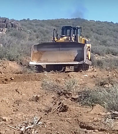
Work today on the road to Laguna Hanson between Rancho El Topo and the Parque Nacional.
|
|
|


