| Pages:
1
2
3 |
Lance S.
Nomad

Posts: 149
Registered: 2-16-2021
Member Is Offline
|
|
San Borja and San Fernando settlements
I was looking at the death records for San Borja from 1768 - 1822, so they begin with the Franciscan takeover. These are the settlements listed.
De la Casa (San Borja)
San Regis
San Juan
San Ignacio
Los Angeles
Rosario
Guadalupe
San Pablo de Calagnujuet
They are all easy enough to find except Guadalupe and San Juan, any ideas? Are they obvious and I'm just not seeing them?
https://www.familysearch.org/ark:/61903/3:1:S3HY-X4SS-R7F?i=...
[Edited on 12-5-2022 by Lance S.]
|
|
|
Lance S.
Nomad
Posts: 149
Registered: 2-16-2021
Member Is Offline
|
|
Was San Pablo de Calagnujuet the name of the church at Calamajue after the Cabacera was moved? The name of the Visita? It was short lived, like it
was being used temporarily for convenience until the population could be reduced to settlements closer to San Borja. Interesting that it was a Visita
of San Borja and not Santa Maria.
[Edited on 10-8-2022 by Lance S.]
|
|
|
David K
Honored Nomad
Posts: 64479
Registered: 8-30-2002
Location: San Diego County
Member Is Offline
Mood: Have Baja Fever
|
|
Guadalupe was on the bay north of Bahia de Los Angeles (aka Remedios).
Calamajué was the mission site for 7 months. No church or visita remained there when Santa Maria was moved.
I will research the name you provided.
[Edited on 10-8-2022 by David K]
|
|
|
4x4abc
Ultra Nomad
Posts: 4163
Registered: 4-24-2009
Location: La Paz, BCS
Member Is Offline
Mood: happy - always
|
|
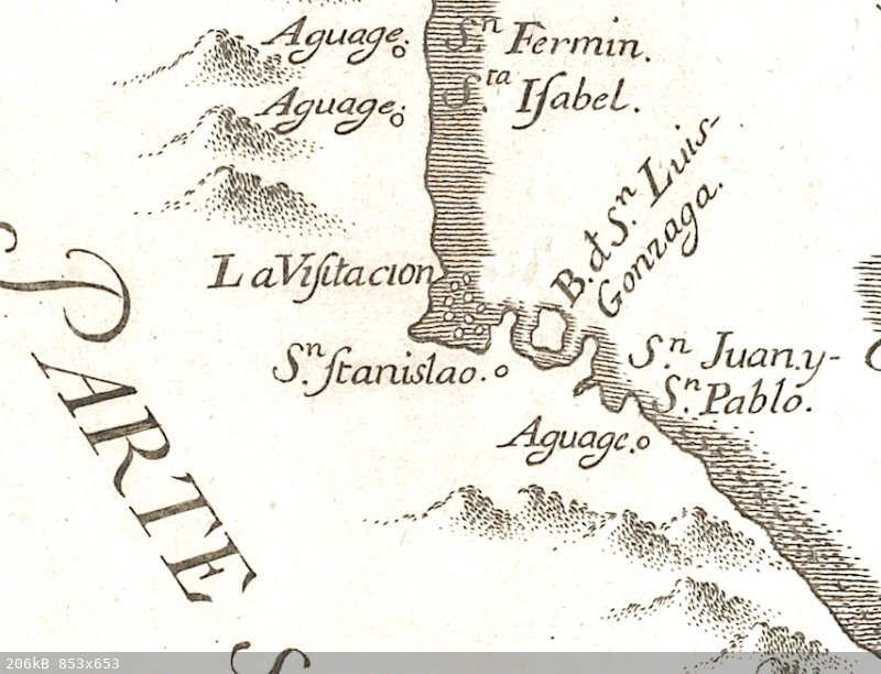
San Juan y San Pablo is the Aguaje (water hole) at Playa Calamajue
Harald Pietschmann
|
|
|
4x4abc
Ultra Nomad
Posts: 4163
Registered: 4-24-2009
Location: La Paz, BCS
Member Is Offline
Mood: happy - always
|
|
never understood the importance of Guadalupe/Remedios.
what made it attractive to the Jesuits?
Harald Pietschmann
|
|
|
bajaric
Senior Nomad
Posts: 602
Registered: 2-2-2015
Member Is Offline
|
|
Seafood?
Perhaps "San Juan" is today called Rancho San Gregorio? Kier noted that the foundation was cut stone blocks typical of the missionary period. San
Gregorio is about 8 miles east of San Borja.
|
|
|
David K
Honored Nomad
Posts: 64479
Registered: 8-30-2002
Location: San Diego County
Member Is Offline
Mood: Have Baja Fever
|
|
Thanks for the 1757 map posted above. I had thought of the San Juan y San Pablo connection after I replied above.
At Bahía Guadalupe, there was (no doubt) a sizeable Native population. That explains why a visita was there, for the padre to visit and teach the
locals about God and the King of Spain.
|
|
|
David K
Honored Nomad
Posts: 64479
Registered: 8-30-2002
Location: San Diego County
Member Is Offline
Mood: Have Baja Fever
|
|
Quote: Originally posted by bajaric  | Seafood?
Perhaps "San Juan" is today called Rancho San Gregorio? Kier noted that the foundation was cut stone blocks typical of the missionary period. San
Gregorio is about 8 miles east of San Borja.
|

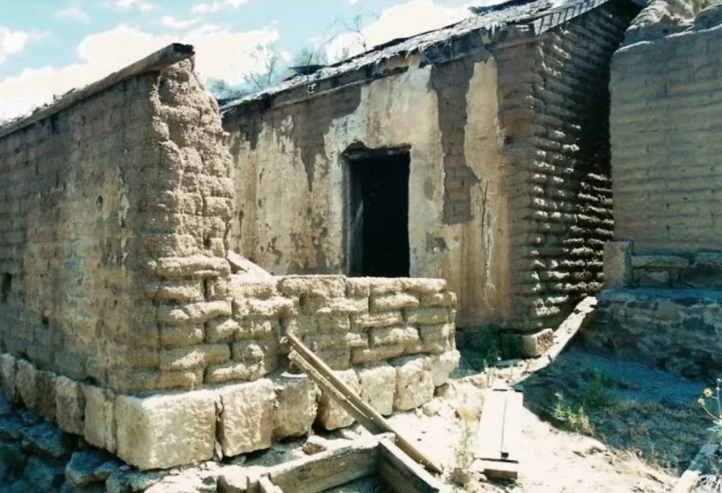
In 2001, Amo Pescar, my son, and I, joined up with Neal & Marian Johns to see old San Gregorio.
In the 1950s, when visited by Howard Gulick (Lower California Guidebook author), San Gregorio was an active ranch...
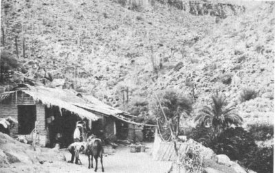
A Nomad search will turn up many more photos I took there.
Here's one more:
[Edited on 10-8-2022 by David K]
|
|
|
Lance S.
Nomad
Posts: 149
Registered: 2-16-2021
Member Is Offline
|
|
Thank you guys,
Did Puerto Calamajue continue to be used for a short period after the expulsion? That could explain San Pablo de Calagnujuet.
If San Pablo de Calagnujuet was a settlement formerly under Calamajue then Rancho San Luis could also be a good candidate. Closer to San Borja so
it would make sense that it would end up under that missions jurisdiction.
San Gregorio is pretty convincing for San Juan, being right off canyon San Juan.
[Edited on 10-11-2022 by Lance S.]
|
|
|
David K
Honored Nomad
Posts: 64479
Registered: 8-30-2002
Location: San Diego County
Member Is Offline
Mood: Have Baja Fever
|
|
| Quote: Originally posted by Lance S. | Thank you guys,
Did Puerto Calamajue continue to be used for a short period after the expulsion? That could explain San Pablo de Calagnujuet.
If San Pablo de Calagnujuet was a settlement formally under Calamajue then Rancho San Luis could also be a good candidate. Closer to San Borja so
it would make sense that it would end up under that missions jurisdiction.
San Gregorio is pretty convincing for San Juan, being right off canyon San Juan.
[Edited on 10-9-2022 by Lance S.] |
The expulsion orders were read to the California Jesuits in December of 1767. The mission at Calamajué was abandoned and relocated up to where we
call 'Santa María' in May of 1767.
The port of Bahía San Luis Gonzaga, where a warehoure was built, was established. It may have not served the Jesuits as much as it did the
Franciscans and Dominicans, who both used it for establishing and supplying the missions of San Fernando and beyond.
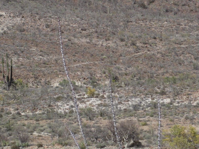
It was Junípero Serra, during his expedition to San Diego from Loreto, in May of 1769, who ordered a trail be established to the shore of Gonzaga
Bay. It passed the 'Antelope Spring', an oasis midway between the El Camino Real (~3.5 miles northward from Santa María) and the bay shore.
This is a paper from Dr. Eric Ritter, who did a dig at the warehouse: https://docs.wixstatic.com/ugd/488b16_d6a1399d09974ddd9dd3b0...
We have called that trail, "Serra's Cargo Trail" perhaps starting when Nomad 'Baja Bucko' rode a mule over it in 2001? The trail is shown on the new
Benchmark Baja Road Atlas, as a branch of El Camino Real. She even placed a virtual geocache there. Some have hiked up to it from Hwy. 5 (the cache
was removed from the website).
Last March, I took this photo of it from the Mission Santa María road, shortly past where the two join:
|
|
|
Lance S.
Nomad
Posts: 149
Registered: 2-16-2021
Member Is Offline
|
|
OK thank you. So it was the Franciscans who had a trail built to Gonzaga. 1769 or after, so I suppose it is possible that Puerto Calamajue was used
for a short time after the expulsion. I will see when San Pablo de Calagnujuet disappears from the register.
|
|
|
David K
Honored Nomad
Posts: 64479
Registered: 8-30-2002
Location: San Diego County
Member Is Offline
Mood: Have Baja Fever
|
|
| Quote: Originally posted by Lance S. | OK thank you. So it was the Franciscans who had a trail built to Gonzaga. 1769 or after, so I suppose it is possible that Puerto Calamajue was used
for a short time after the expulsion. I will see when San Pablo de Calagnujuet disappears from the register.
|
Please keep up the research! "The truth is out there"
|
|
|
Lance S.
Nomad
Posts: 149
Registered: 2-16-2021
Member Is Offline
|
|
I just stumbled across father Mora's visit on page 63, neat. Hope the link works.
https://www.familysearch.org/ark:/61903/3:1:S3HY-X4SS-5BG?i=...
|
|
|
4x4abc
Ultra Nomad
Posts: 4163
Registered: 4-24-2009
Location: La Paz, BCS
Member Is Offline
Mood: happy - always
|
|
is there any known water source at Los Remedios/Guadalupe?
why would the bay get the name "Remedy"?
remedy for what?
Harald Pietschmann
|
|
|
4x4abc
Ultra Nomad
Posts: 4163
Registered: 4-24-2009
Location: La Paz, BCS
Member Is Offline
Mood: happy - always
|
|
I have 2 locations for San Juan:
Rancho San Juan 28°40'43.72"N, 113°40'25.44"W (seems newer)
and
Rancho Aguaje de San Juan 28°39'56.20"N, 113°36'1.61"W (historic location)
Harald Pietschmann
|
|
|
4x4abc
Ultra Nomad
Posts: 4163
Registered: 4-24-2009
Location: La Paz, BCS
Member Is Offline
Mood: happy - always
|
|
Los Remedios
https://www.behindthename.com/name/remedios
Harald Pietschmann
|
|
|
Lance S.
Nomad
Posts: 149
Registered: 2-16-2021
Member Is Offline
|
|
Goldbaum map shows Guadalupe at the south end of Remedios at or near the shore.
[Edited on 10-9-2022 by Lance S.]
|
|
|
4x4abc
Ultra Nomad
Posts: 4163
Registered: 4-24-2009
Location: La Paz, BCS
Member Is Offline
Mood: happy - always
|
|
| Quote: Originally posted by lencho |
Edit: While I was looking for background, I ran upon a couple of really cool documents from the Secretaría de Marina giving a lot of
navegation detail for both coasts of the peninsula:
West Coast
East Coast
[Edited on 10-9-2022 by lencho] |
I have been using those papers a lot
locate lighthouses, puertos etc
however, lotsa wrong locations
hey, its a Mexican paper
the lat/long below will send you to the mountains - not to a lighthouse

Harald Pietschmann
|
|
|
Lance S.
Nomad
Posts: 149
Registered: 2-16-2021
Member Is Offline
|
|
| Quote: Originally posted by 4x4abc | I have 2 locations for San Juan:
Rancho San Juan 28°40'43.72"N, 113°40'25.44"W (seems newer)
and
Rancho Aguaje de San Juan 28°39'56.20"N, 113°36'1.61"W (historic location)
|
That second one gets my vote.
|
|
|
Lance S.
Nomad
Posts: 149
Registered: 2-16-2021
Member Is Offline
|
|
Is that second one the same place mentioned here?
http://forums.bajanomad.com/viewthread.php?tid=59017
San Gregorio and Aguaje de San Juan are so close together I imagine they both would have been part of the same estancia.
[Edited on 10-9-2022 by Lance S.]
|
|
|
| Pages:
1
2
3 |


