| Pages:
1
2
3 |
4x4abc
Ultra Nomad

Posts: 4193
Registered: 4-24-2009
Location: La Paz, BCS
Member Is Offline
Mood: happy - always
|
|
sometimes easy looking 4x4 tracks turn into nightmare hikes
Rabncho Los Palmares close to San Evaristo
https://carlosnpainter.smugmug.com/Events/Los-Palmares-hike-...
Harald Pietschmann
|
|
|
David K
Honored Nomad
Posts: 64517
Registered: 8-30-2002
Location: San Diego County
Member Is Offline
Mood: Have Baja Fever
|
|
That is a long ways from Santa Maria... Do you have anything more of the area in discussion than the map you started this thread with?
Thanks!
|
|
|
mtgoat666
Select Nomad
Posts: 17372
Registered: 9-16-2006
Location: San Diego
Member Is Offline
Mood: Hot n spicy
|
|
Quote: Originally posted by David K  | I think that is close about right (4-5 miles shorter) at a glance.
Good question for Harald about his colors!
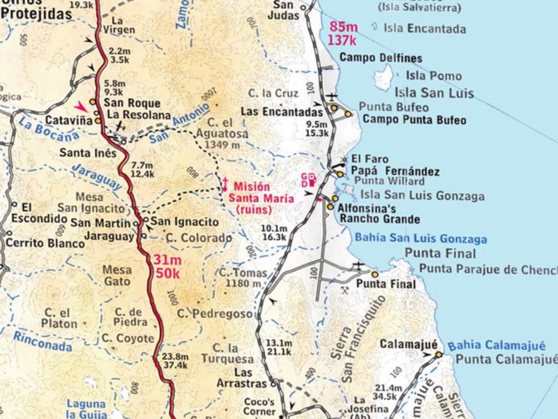
Here is the trail east from San Ignacito shown incorrectly as being the same as the auto road from Santa Inés, in the 2003 Baja Almanac folding map:
[Edited on 11-11-2022 by David K] |
So the “new” road is not really new, but just an old route refreshed?
Woke!
“...ask not what your country can do for you – ask what you can do for your country.” “My fellow citizens of the world: ask not what America
will do for you, but what together we can do for the freedom of man.”
Prefered gender pronoun: the royal we
|
|
|
David K
Honored Nomad
Posts: 64517
Registered: 8-30-2002
Location: San Diego County
Member Is Offline
Mood: Have Baja Fever
|
|
Please read what I posted and not just look at the pictures.
|
|
|
mtgoat666
Select Nomad
Posts: 17372
Registered: 9-16-2006
Location: San Diego
Member Is Offline
Mood: Hot n spicy
|
|
I did. Based on that, it appears that 2003 map showed a route (trail or road) where harry found a new road, eh?
Woke!
“...ask not what your country can do for you – ask what you can do for your country.” “My fellow citizens of the world: ask not what America
will do for you, but what together we can do for the freedom of man.”
Prefered gender pronoun: the royal we
|
|
|
David K
Honored Nomad
Posts: 64517
Registered: 8-30-2002
Location: San Diego County
Member Is Offline
Mood: Have Baja Fever
|
|
Harald does not go by Harry.
There is a new road, yes... over the first 2/3 to 3/4 of the older foot trail. We knew about the new road before Harald's post, but it was not
publicized too much.
|
|
|
geoffff
Senior Nomad
Posts: 644
Registered: 1-15-2009
Member Is Offline
|
|
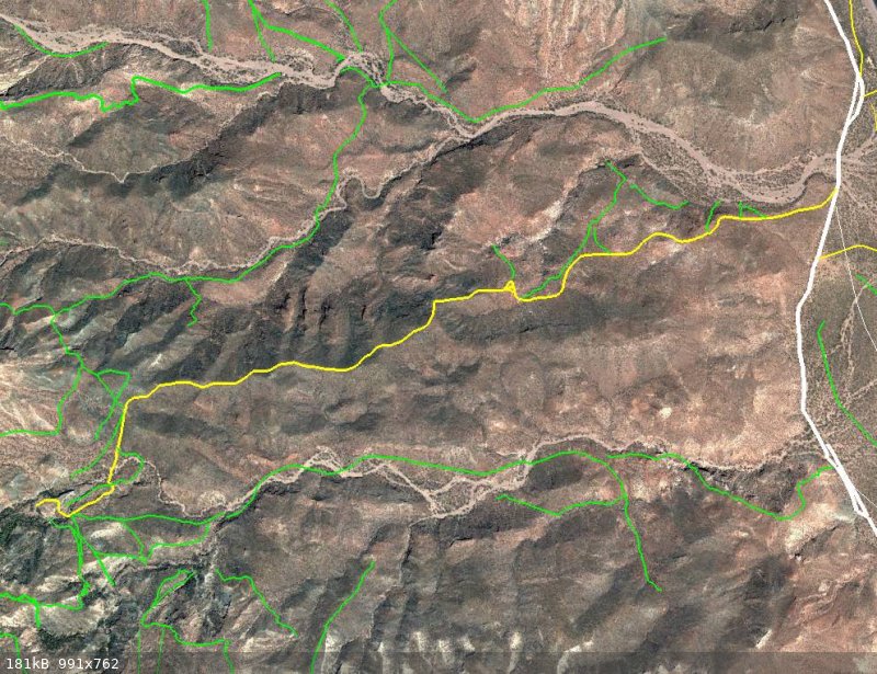
| Quote: Originally posted by 4x4abc |
black = pavement
white = mining trail or new 4x4 track
yellow = rural 4x4 road
green = animal trail or Camino Real
|
That's an amazing project, Harald! You've mapped all these trails by tracing the satellite imagery? Do you have big plans for this? This would make a
fantastic backcountry exploration map!
|
|
|
4x4abc
Ultra Nomad
Posts: 4193
Registered: 4-24-2009
Location: La Paz, BCS
Member Is Offline
Mood: happy - always
|
|
| Quote: Originally posted by geoffff | | Quote: Originally posted by 4x4abc |
black = pavement
white = mining trail or new 4x4 track
yellow = rural 4x4 road
green = animal trail or Camino Real
|
That's an amazing project, Harald! You've mapped all these trails by tracing the satellite imagery? Do you have big plans for this? This would make a
fantastic backcountry exploration map! |
not sure what to do with it yet
it is a powerful research tool
with a few clicks I can show anything someone needs
everything with a name is searchable
and with a click I can remove all clutter other maps have
to concentrate on just one topic
right now chasing lost or missed Camino Real sections around Mision Santa Maria
including the forgotten Jaraguay to Las Palmitas trail
Harald Pietschmann
|
|
|
mtgoat666
Select Nomad
Posts: 17372
Registered: 9-16-2006
Location: San Diego
Member Is Offline
Mood: Hot n spicy
|
|
Your map is nice, it is clearly labeled, much clearer map than what harry and David posted.
Woke!
“...ask not what your country can do for you – ask what you can do for your country.” “My fellow citizens of the world: ask not what America
will do for you, but what together we can do for the freedom of man.”
Prefered gender pronoun: the royal we
|
|
|
David K
Honored Nomad
Posts: 64517
Registered: 8-30-2002
Location: San Diego County
Member Is Offline
Mood: Have Baja Fever
|
|
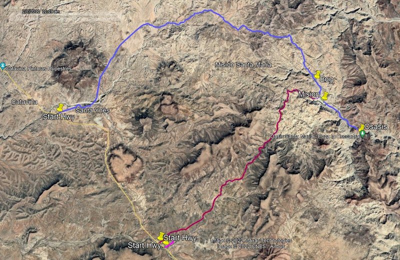
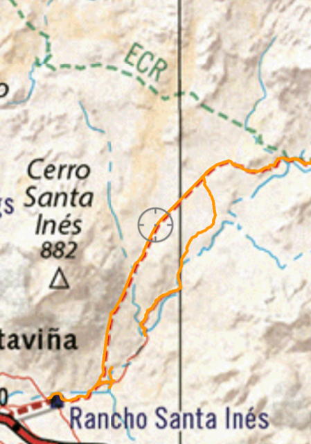
Paul, that looks like the original road for the first 5 or so miles. It has been abandoned in favor of the smoother 'arroyo road'.
Here are my GPS tracks on both from 8 months ago:
Overall:
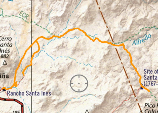
Zoom in (a bit of the new route didn't record, I may have accidentally hit the off button):
My map of 2018 of the general area:
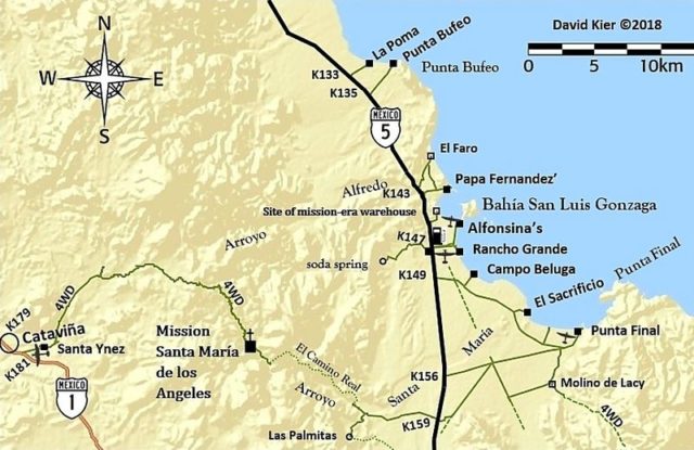
The GPS track map is the 2021 Baja California Atlas from Benchmark and the tracking was done with my cell phone that had the Avenza Map App and the
Benchmark Baja map download. Cell phones have GPS so the app works great as a live traveling map and has track recording available.
2021 Benchmark Digital Baja Map from Avenza's web page
https://www.avenzamaps.com/maps/1250162/baja-california-atla...
|
|
|
PaulW
Ultra Nomad
Posts: 3015
Registered: 5-21-2013
Member Is Offline
|
|
I saw the exit from the arroyo, but followed the obvious road track. I will add the arroyo track later today and delete the current image.
Now that we have current Google earth images the almanac and Atlas will be second choices.
I wish had an Apple tablet to use for Avenza instead of my phone. Bigger is always better.
|
|
|
4x4abc
Ultra Nomad
Posts: 4193
Registered: 4-24-2009
Location: La Paz, BCS
Member Is Offline
Mood: happy - always
|
|
sharing tracks is easy
creating them is a lot of work
enjoy!
Attachment: 4x4 rural new Mision Santa Maria Road.kmz (30kB)
This file has been downloaded 87 times
Attachment: Camino Real Santa Maria N.kmz (5kB)
This file has been downloaded 66 times
Harald Pietschmann
|
|
|
4x4abc
Ultra Nomad
Posts: 4193
Registered: 4-24-2009
Location: La Paz, BCS
Member Is Offline
Mood: happy - always
|
|
here are the latest 2 routes I am working on
Santa Maria ECR north alternative
Attachment: Santa Maria ECR north alt.kmz (863B)
This file has been downloaded 66 times
Jaraguay to Las Palmitas
Attachment: Jaraguay - Las Palmitas.kmz (1kB)
This file has been downloaded 66 times
Harald Pietschmann
|
|
|
PaulW
Ultra Nomad
Posts: 3015
Registered: 5-21-2013
Member Is Offline
|
|
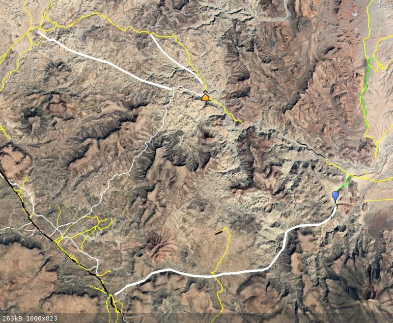
Roads to Mision Santa Maria - Revised
Roads to Mision Santa Maria - Revised
My try for the various tracks from Google Earth
Same tracks Harald posted above and now I have the GPS tracks.

|
|
|
David K
Honored Nomad
Posts: 64517
Registered: 8-30-2002
Location: San Diego County
Member Is Offline
Mood: Have Baja Fever
|
|
You can drive just over a mile from the mission towards the oasis. Howevr, it is only a steep hike on a narrow trail to the oasis, which is way down
at the bottom of the canyon.
|
|
|
PaulW
Ultra Nomad
Posts: 3015
Registered: 5-21-2013
Member Is Offline
|
|
Harald
thanks for the KMZs
|
|
|
4x4abc
Ultra Nomad
Posts: 4193
Registered: 4-24-2009
Location: La Paz, BCS
Member Is Offline
Mood: happy - always
|
|
| Quote: Originally posted by David K | | You can drive just over a mile from the mission towards the oasis. Howevr, it is only a steep hike on a narrow trail to the oasis, which is way down
at the bottom of the canyon. |
from where you park your car it is an easy walk
nothing steep, nothing narrow
the last few meters into the pool are down a vertical cliff
about 30 feet down
when I lead groups in there long long ago (we came from the bottom) I brought mountain climbing gear (hooks, ropes etc) for my clients
safety first
I can do it barefoot in a couple of minutes
but if you have never done it, it is dangerous
Harald Pietschmann
|
|
|
David K
Honored Nomad
Posts: 64517
Registered: 8-30-2002
Location: San Diego County
Member Is Offline
Mood: Have Baja Fever
|
|
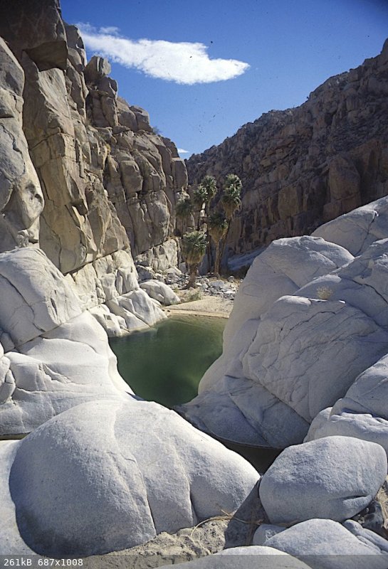
I am talking about the Indian trail (and was the first El Camino Real route) from the end of the bulldozed road, past the petroglyphs, and down to the
canyon bottom... That is indeed very steep, and very narrow.
When I flew over that place on a recon in 1999:

The bulldozed road is on the lower half, left side, going up to the canyon edge. The foot trail continues from there down to the canyon bottom in the
upper half.
Sounds like you are speaking of coming up the canyon floor from the Gonzaga Bay side of the peninsula... very wide and not steep at all!
|
|
|
4x4abc
Ultra Nomad
Posts: 4193
Registered: 4-24-2009
Location: La Paz, BCS
Member Is Offline
Mood: happy - always
|
|
using the Indian trail to get to the pool is 3 times as long and much more difficult than from the upper canyon
after the dozer end the Indian trail is easy for 3/4 of the way to the canyon floor
the last part is nasty
steep and hard to follow
I checked the new sat images last night
it looks like Camino Real above the canyon has seen a lot of traffic recently

easy stretch of the Indian Trail
Harald Pietschmann
|
|
|
David K
Honored Nomad
Posts: 64517
Registered: 8-30-2002
Location: San Diego County
Member Is Offline
Mood: Have Baja Fever
|
|
As I said, it is narrow, looks like a foot wide in your photo... great photo!
|
|
|
| Pages:
1
2
3 |