| Pages:
1
2 |
PaulW
Ultra Nomad

Posts: 3005
Registered: 5-21-2013
Member Is Offline
|
|
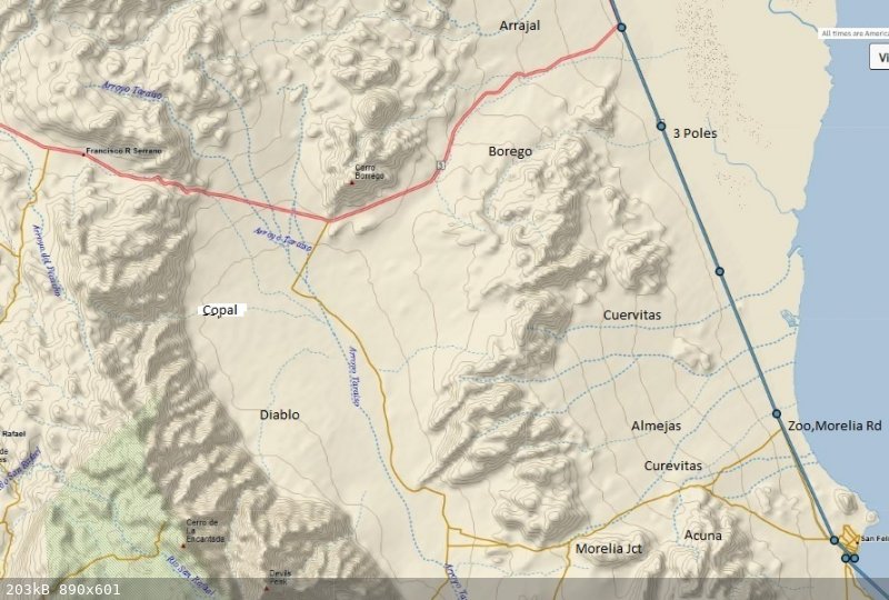
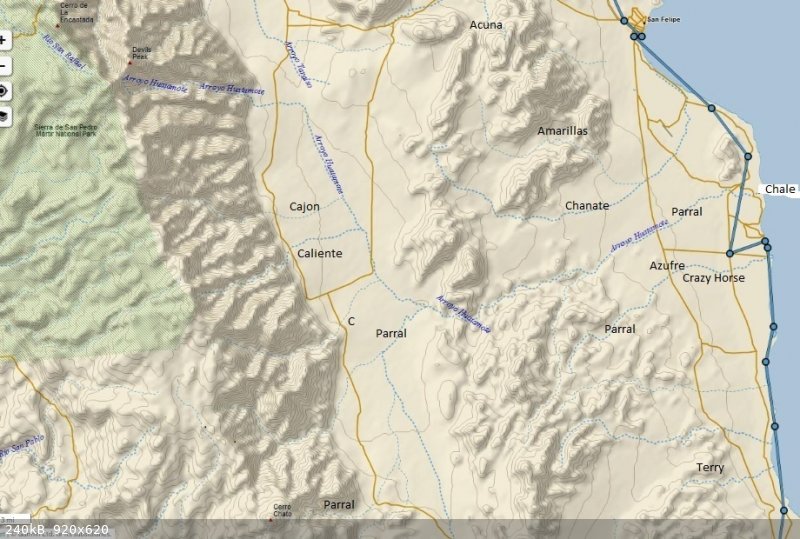
inReach Images
Arroyos between East coast and mountains shown on my map from inReach track
I was reminded by the location and extension of Taraiso and the extension of Huatamote
Dark black labels are my addition.
|
|
|
David K
Honored Nomad
Posts: 64478
Registered: 8-30-2002
Location: San Diego County
Member Is Offline
Mood: Have Baja Fever
|
|
Cool, but what or where is 'Taraiso'?
Here is the list and maps of the Valle Chico canyons we all worked on: https://vivabaja.com/canyons/
|
|
|
PaulW
Ultra Nomad
Posts: 3005
Registered: 5-21-2013
Member Is Offline
|
|
|
|
|
RFClark
Super Nomad
Posts: 2331
Registered: 8-27-2015
Member Is Offline
Mood: Looking forward to 2024
|
|
Hi all,
El Taraiso was the Patriarch of Constantinople from 784- 806. The name is the Spanish spelling of the Greek name “Ταράσιος“ There are
hills in Cuba named after him as well.
|
|
|
David K
Honored Nomad
Posts: 64478
Registered: 8-30-2002
Location: San Diego County
Member Is Offline
Mood: Have Baja Fever
|
|
Nothing too 'historical' in my collections. The name appears on the Mexican topo maps only, and thus it is on the Baja Almanac and Benchmark Atlas,
which use the government maps for data.
In the 1958 edition of the Lower California Guidebook, Howard Gulick mentions the road north from the mouth of San Matías Pass: "A road goes left via
Arroyo Teraizo to Arroyo Grande ranch."
Partway in, from Hwy. 3 is a ranch or settlement with the name El Taraizo and listed as a Kiliwa (Indian) settlement, but when examined on satellite
imagery, the buildins are in ruins, with no roofs.

On one 2005 Baja state map, made in Mexico, it shows the arroyo as 'Río Paraíso'... Link:
2005 EIGAS State of Baja California Map
On VivaBaja.com/maps, I have links to the Native place names:
Kiliwa Tribal Lands:
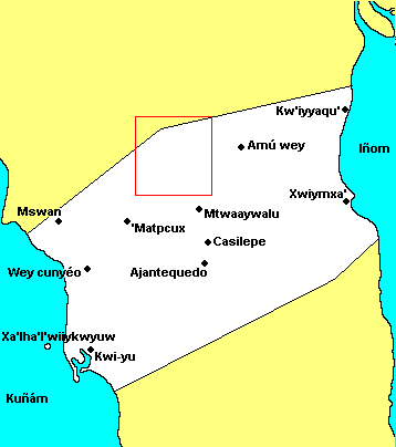
Here is the Kiliwa area, in question, close up (square from above map:
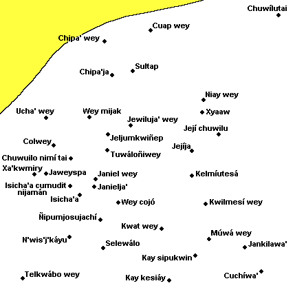
Nothing close to Taraiso shown.
[Edited on 12-3-2022 by David K]
|
|
|
David K
Honored Nomad
Posts: 64478
Registered: 8-30-2002
Location: San Diego County
Member Is Offline
Mood: Have Baja Fever
|
|
Sorry it wasn't clearer, this is what I posted: "The name appears on the Mexican topo maps only."
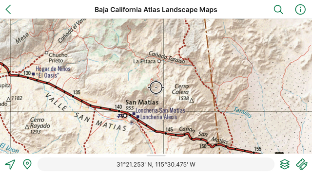
The topo image is from the wonderful map site: CalTopo.com (linked at VivaBaja.com/maps) Here is at the location: https://caltopo.com/map.html#ll=31.36311,-115.46403&z=15...
Nomad 'geoffff' can advise you more about it.
|
|
|
PaulW
Ultra Nomad
Posts: 3005
Registered: 5-21-2013
Member Is Offline
|
|
Look at H11B35
|
|
|
David K
Honored Nomad
Posts: 64478
Registered: 8-30-2002
Location: San Diego County
Member Is Offline
Mood: Have Baja Fever
|
|
Use CalTopo, which has those maps loaded... or do it the hard way, as Paul does (  ) and use the INEGI link on VivaBaja.com/maps at this link near the top:
Mexican Topographic Maps from INEGI (choose scale, area, and click PDF or GeoPDF where available) >>> https://www.inegi.org.mx/temas/topografia/
|
|
|
David K
Honored Nomad
Posts: 64478
Registered: 8-30-2002
Location: San Diego County
Member Is Offline
Mood: Have Baja Fever
|
|
If you click the CalTopo link I provided above, it takes you to the INEGI maps. Plus, you can change to other versions (like slope shading and hybrid
satellite. Also, switch to satellite imaging to see actual building or artifact locations and how close the topo map is correct. Usually, there is a
difference.
|
|
|
PaulW
Ultra Nomad
Posts: 3005
Registered: 5-21-2013
Member Is Offline
|
|
If you are good for the rabbet hole go to the INEGI site and download the older maps. Geoff used the latest INEGI images when he did his creation.
Make me wonder if there newer INEGI updates for the mountains and canyons we are interested in?
|
|
|
David K
Honored Nomad
Posts: 64478
Registered: 8-30-2002
Location: San Diego County
Member Is Offline
Mood: Have Baja Fever
|
|
lencho, since Howard Gulick recorded the name for his 1958 guide, it predates INEGI's maps. He probably got the name locally or from another map.
|
|
|
David K
Honored Nomad
Posts: 64478
Registered: 8-30-2002
Location: San Diego County
Member Is Offline
Mood: Have Baja Fever
|
|
I gave you that this morning with the maps (6:18 am)... Arroyo Teraizo.
|
|
|
PaulW
Ultra Nomad
Posts: 3005
Registered: 5-21-2013
Member Is Offline
|
|
Quote: Originally posted by David K  | | lencho, since Howard Gulick recorded the name for his 1958 guide, it predates INEGI's maps. He probably got the name locally or from another map.
|
==
Made me look
My Gulick book is 4th edition (1967) and I wonder if the words changed regarding Teraizo? First edition seems to be 1956.
I have discussed with friends here in San Felipe. The input was that travel in that canyon was not suggested because there are locked gates at both
the north, or headwaters, and south at Hwy3. Some time ago I confirmed the south end gate locked. My old GPS map depicts a go around the south gate
thru the abandoned pig farm. Google Earth shows go around and other faint tracks.
|
|
|
PaulW
Ultra Nomad
Posts: 3005
Registered: 5-21-2013
Member Is Offline
|
|
Google insists on giving results for Paraíso instead of Teraizo.
|
|
|
David K
Honored Nomad
Posts: 64478
Registered: 8-30-2002
Location: San Diego County
Member Is Offline
Mood: Have Baja Fever
|
|
The four guidebook editions were 1956, 58, 62, & 67. I have all four. In addition, there were second printings in 1964 and 1970. This was a truly
amazing work by Howard Gulick (and historian Peter Gerhard).
Gulick didn't examine the road/ canyon in the first edition.
Google is wrong so many times with Baja names I could never document them all! INEGI is also wrong a lot!
|
|
|
PaulW
Ultra Nomad
Posts: 3005
Registered: 5-21-2013
Member Is Offline
|
|
I guess that means Gulick/Gerhard found about Teraizo from either his references or from local communication. Have you looked for documents or maps
that they might have used back then?
|
|
|
David K
Honored Nomad
Posts: 64478
Registered: 8-30-2002
Location: San Diego County
Member Is Offline
Mood: Have Baja Fever
|
|
| Quote: Originally posted by PaulW | | I guess that means Gulick/Gerhard found about Teraizo from either his references or from local communication. Have you looked for documents or maps
that they might have used back then? |
From the Lower California Guidebook:
The following are the maps from all four editions, stitched together with zoom detail...
1956 maps: 1956 Maps
1958 maps: 1958 maps
1962 (& 1967) maps: 1962 maps
[Edited on 12-4-2022 by David K]
|
|
|
David K
Honored Nomad
Posts: 64478
Registered: 8-30-2002
Location: San Diego County
Member Is Offline
Mood: Have Baja Fever
|
|
Howard was an engineer (for the city of Glendale, CA) and he was a detail-holic, indeed. You can see it in his guidebook style.
The book was known as the 'Baja Bible' and a standard to emulate by Baja nerds, like me!
Meeting Howard before our 1966 trip to the tip was a thrill for young me, who was just beginning his Baja addiction, with his parents.
|
|
|
geoffff
Senior Nomad
Posts: 643
Registered: 1-15-2009
Member Is Offline
|
|
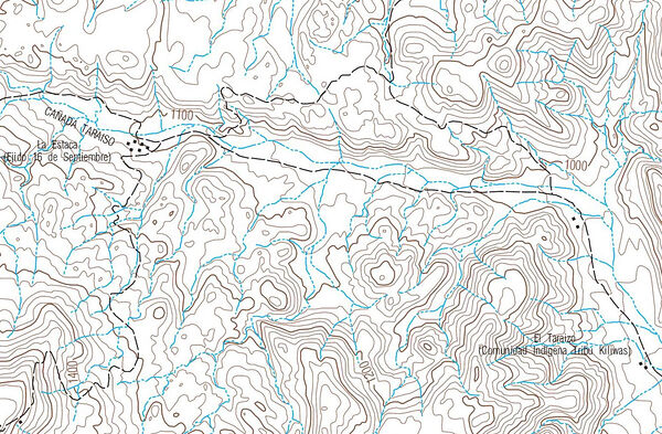
modern INEGI map

old INEGI map

Lower California Guidebook 1970 mentions "Teraizo", but the word is not on the map itself.
|
|
|
AKgringo
Elite Nomad
Posts: 5805
Registered: 9-20-2014
Location: Anchorage, AK (no mas!)
Member Is Offline
Mood: Retireded
|
|
It is interesting that at the western side of the drainage it is spelled Teraiso, but toward the east it is Teraizo.
If you are not living on the edge, you are taking up too much space!
"Could do better if he tried!" Report card comments from most of my grade school teachers. Sadly, still true!
|
|
|
| Pages:
1
2 |


