Fatboy
Senior Nomad

Posts: 801
Registered: 6-28-2005
Member Is Offline
|
|
El Camino Real (Again) Part 1
Here I go again.
Work ½ a day.
Drive 575 miles to Indio, crash in the Hilton for the night.
Next day I drive to Calexico, do some last minute shopping, fill up with gas, exchange some dollars to pesos.
Drive across the International Border and be waved over for inspection.
Drive through Mexicali (and bonus points for not getting lost this time!) and head south towards San Felipe.
Have a brief inspection at the military checkpoint.
Drive through San Felipe, Puertecitoes, Gonzaga Bay where I fill up the gas
s tank again, and then on to Lake Chapala where I spend the night.
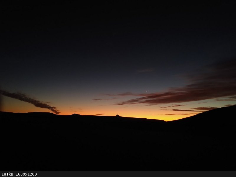
Up early the next day, boil some water, make some coffee, pack up camp and head south again.
Another brief inspection at the military checkpoint and on to Villa Jesus Maria where I again fill up the gas tank and stop at Kassandra's for some
delicious burritos before heading south.
Stop and pay the 20 peso's to have the bottom of my car misted at the 28th parallel.
Bypass Guerrero Negro, pass a coyote relieving himself on the shoulder, and then pass my turn off to El Arco. A quick u-turn and I am on dirt roads
were I will be for the next 6 days.
Drive the 22 miles to and then through El Arco, to the turn off to Pozo Aleman.
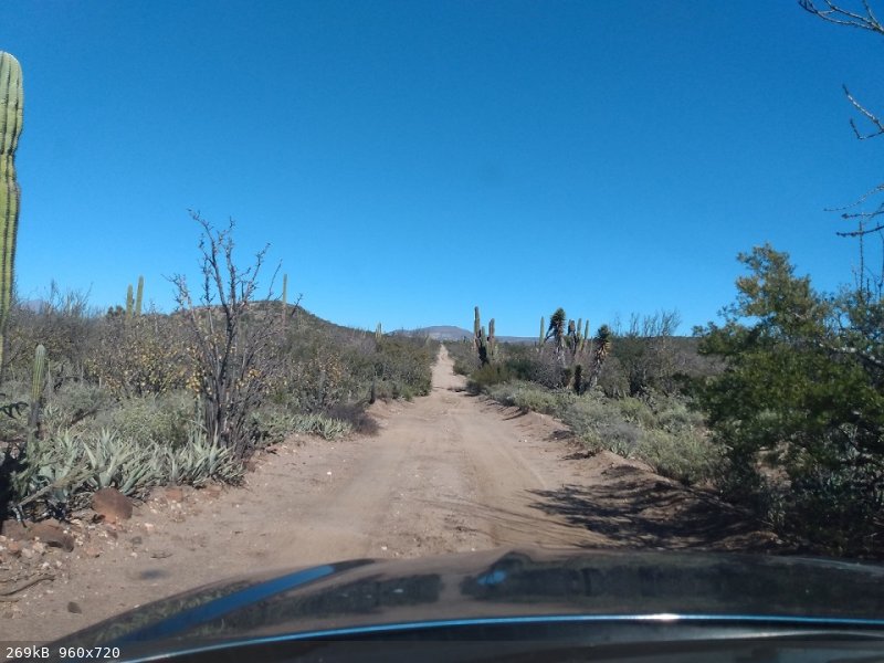
12 miles takes me through Pozo Aleman and then through Calmalli to my turn off on an even less traveled dirt road.
Then to a massive wash (La Sandia) which has me worried. It looks like loose sand and it is probably a ½ mile. All I can think about is making it
part way across, hitting a soft spot and sinking the Subaru.
Yeah, I am driving a 15 year old Subaru with street tires.
I walk across the wash and back and believe I can make it.
I buckle up, start the car and away I go.
Up the far side and on to Rancho Nuevo where I pull up and Francisco comes out and I try to explain that I wanted to park nearby and go walk in the
desert for a week.
He kindly offers his yard and I kindly decline hoping to get a little closer to Los Corrales where I ended my hike the year before.
1139 miles after leaving home I find a place to park and camp for the night, and spend the rest of the afternoon getting the backpack ready.
Read Part 2 here
Read Part 3 here
Read Part 4 here
Read about my 2022 ECR Hike here
[Edited on 1-18-2023 by Fatboy]
|
|
|
AKgringo
Elite Nomad
Posts: 6176
Registered: 9-20-2014
Location: Anchorage, AK (no mas!)
Member Is Online
Mood: Retireded
|
|
I'm looking forward to more! Are you still in Baja, or back in NorCal writing this?
If you are not living on the edge, you are taking up too much space!
"Could do better if he tried!" Report card comments from most of my grade school teachers. Sadly, still true!
|
|
|
Fatboy
Senior Nomad
Posts: 801
Registered: 6-28-2005
Member Is Offline
|
|
I got home late last night....
I set my sights a lot lower on this trip and it was much harder than the first one...
|
|
|
David K
Honored Nomad
Posts: 65236
Registered: 8-30-2002
Location: San Diego County
Member Is Offline
Mood: Have Baja Fever
|
|
Wonderful and thanks for sharing.
I will enjoy comparing your description to maps.
What was your ECR location source, CaminoRealBaja.com or ?
Great that you didn't 'vanish' from Nomad, after this adventure!
|
|
|
Fatboy
Senior Nomad
Posts: 801
Registered: 6-28-2005
Member Is Offline
|
|
A variety of sources and certainly pulled waypoints from CaminoRealBaja.com.
Going up what the Almanac calls La Rabia seems like a hard way for the Padres to have gone.
On the other hand there does appear to have 2 spots that have water longer than the rest, maybe even year round, which would explain using it.
Using qoogle to translate what La Rabia means might explain it somewhat....
About halfway up I was very frustrated by this canyon, it just seemed to throw up one road block after another.
|
|
|
bajaric
Senior Nomad
Posts: 656
Registered: 2-2-2015
Member Is Offline
|
|
Gabb, during an 1867 expedition, seemed to have little trouble negotiating the ECR on horseback, passing San Sebastion. Perhaps in the intervening
150 years parts of the trail have been washed out.
I imagine that portion of the ECR saw relatively little foot traffic to begin with. It would have been easier to take a boat to get from Baja Sur to
the northern missions.
I have found that when exploring a new area it takes a while to get the lay of the land and find the correct route. And that is driving a vehicle,
not bashing through the cactus on foot. In really remote areas I print out a screen shot from Google Earth and mark the road junctions, etc. with
latitude and longitude to compare with a handheld GPS.
|
|
|
David K
Honored Nomad
Posts: 65236
Registered: 8-30-2002
Location: San Diego County
Member Is Offline
Mood: Have Baja Fever
|
|
Good morning Fatboy/ECR fans,
Thanks for the additional intel, Fatboy. Thanks for the Gabb history, as well, bajaric.
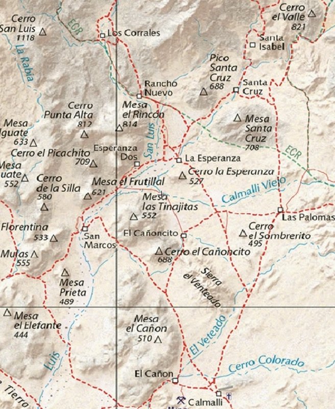
I like looking at places Fatboy names, from satellite and seeing the places on the Benchmark Baja Atlas, which has the ECR (El Camino Real) route
plotted on it. Their source also was www.CaminoRealBaja.com (the couple from the Pacific Northwest who have been backpacking the mission roads for the past 22 years and plotting their
waypoints on GoogleEarth).
Let's see if I can share these after each part of Fatboy's travels...
I think we all know where El Arco is (just north of the state border, in the center of the peninsula)... and Pozo Alemán is just over two miles from
El Arco (just off the road going to Punta San Francisquito).
Calmallí is five miles north of Pozo Alemán, once a major gold mine center with 20 stamp mills, in 1883.
The map below shows Calmallí at the bottom, and Los Corrales near the top, along ECR (El Camino Real). The Arroyo La Sandia crossing is by La
Esperanza (on the map), then see Rancho Nuevo, going north.
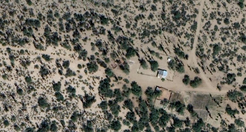
This image of Rancho Nuevo, with the auto road to Los Corrales going north (top of map) and the El Camino Real passing through from right to left
(auto tracks over it here):
|
|
|
Fatboy
Senior Nomad
Posts: 801
Registered: 6-28-2005
Member Is Offline
|
|
It appears that La Esperanza is deserted, along with Tres Palmas and San Sebastian.
Last year I hiked from La Union to Los Corrales (which I said was Rancho Nuevo last year by mistake) and this year I picked up where I left off.
As far as Gabb is concerned, the trip to San Sebastian would be more straight forward but according to some sources it is an alternative route to the
actual ECR.
The trail from San Sebastian drainage over to the La Rabia drainage is sometimes noted as a 'tie' trail.
The big problem I had this year was the giant floods from a few months back. Cows and ranchers still use parts of the old trail but all the banks were
cut back several feet from the floods and you could not tell where they left the wash anymore.
Sometimes I knew there had to be a trail cutting off a bend to the wash that I would go look for and probably had a 50/50 success rate in finding it.
When I didn't find it then I just had to push through dense brush which was even slower going than the wash was.
|
|
|
David K
Honored Nomad
Posts: 65236
Registered: 8-30-2002
Location: San Diego County
Member Is Offline
Mood: Have Baja Fever
|
|
From space, the ECR in the upper half of La Rabia is easy to see, although it looks like a catttle track and not the built-road. Here is where it is
about to cut across the arroyo from west to east sides: 28.3997, -113.5435
The trail from San Sebastian meets the La Rabia route and just a few meters west is a large, attractive pond: 28.4096, -113.5525
The first typical, straight, Jesuit example of road building begins here, on Mesa Las Palmas: 28.4313, -113.5806
Dropping away from the mesa, enroute to Mission San Borja, the harshness of this land is so clear: 28.4536, -113.5866
The El Paraiso Canyon was the largest obsticle the Jesuits crossed. Here is the top of the south cuesta (switchback/ grade). This is the
location for the cover photo of Harry's book: 28.5255, -113.6387
[to easily see the satelite image for a GPS waypoint, using your desktop mouse:
highlight the waypoint,
right click mouse,
click 'search Google for',
click on the small map to enlarge,
click on the layers option in the lower left corner,
choose 'satellite'... now you can zoom in and follow the old road!]

|
|
|
Fatboy
Senior Nomad
Posts: 801
Registered: 6-28-2005
Member Is Offline
|
|
I will check that out when I get off work tonight... Be interesting to see how it matches what I experienced on the ground.
|
|
|
David K
Honored Nomad
Posts: 65236
Registered: 8-30-2002
Location: San Diego County
Member Is Offline
Mood: Have Baja Fever
|
|
Quote: Originally posted by Fatboy  | | I will check that out when I get off work tonight... Be interesting to see how it matches what I experienced on the ground. |
For sure... you were just there, after Hurricane Kay... the satellite view is maybe from earlier in 2022, at best.
Thank you for making Nomad intersting, once again!

|
|
|
Fatboy
Senior Nomad
Posts: 801
Registered: 6-28-2005
Member Is Offline
|
|
| Quote: Originally posted by David K | From space, the ECR in the upper half of La Rabia is easy to see, although it looks like a catttle track and not the built-road. Here is where it is
about to cut across the arroyo from west to east sides: 28.3997, -113.5435
The trail from San Sebastian meets the La Rabia route and just a few meters west is a large, attractive pond: 28.4096, -113.5525
|
Your first landmark has my GPS track going right through it.... so I hit that about dead on.
Your second one is where I went wrong on day 3. I should have turned right or North right at your marker but I followed what was obvious trail that
led me astray.
Because of the recent flood the junction of those two drainages are all messed up and there was no clear trail to north right there.
|
|
|
advrider
Super Nomad
Posts: 1898
Registered: 10-2-2015
Member Is Offline
|
|
Love following your hikes. I hope to make about 800- 1000 PCT miles this summer then maybe take a break next year. Maybe I can catch up with you for
some Baja hiking. I'm retired now so my schedule is pretty flexible.
|
|
|
Fatboy
Senior Nomad
Posts: 801
Registered: 6-28-2005
Member Is Offline
|
|
Are you picking up where you left off?
As much as I want to I will probably not do anymore hiking in baja this year but I will certainly do some stuff in utah mid to late spring if your
interested.
Will hike up on the Kairparowits Plateau and look for indian ruins. It is off trail mostly and at 7,000 feet.
|
|
|


