Fatboy
Senior Nomad

Posts: 711
Registered: 6-28-2005
Member Is Offline
|
|
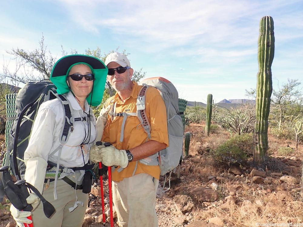
El Camino Real (Again) Part 2
Early Sunday morning I hoist my pack, which is much too heavy with food for 5 days and 2 gallons of water.
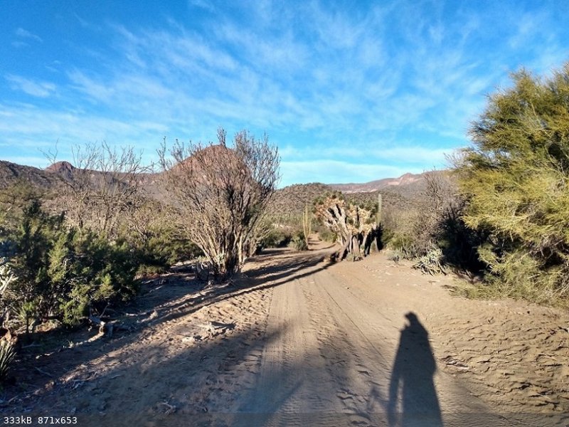
A few minutes of road walking and then I am in the wash in front of Rancho Los Corralles where I had turned around the year before.
From here on out it was all going to be new to me. Trudging along in the loose sand of the wash with a 35 lbs backpack was not much fun and I was
barely past the Rancho when I came upon water. and within a mile I was along side a small running stream that would be with me for four of the next
five days.
I wanted to dump all my water out right then and there and lighten my pack by over 15 pounds but I wasn't sure at the time what the future had in
store for me.
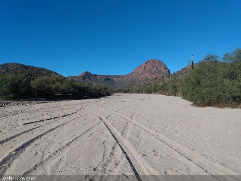
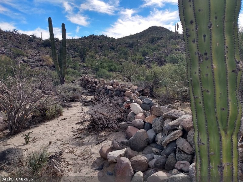
I hike up the wash past the historic site of Tres Palmas. There is not much to see there, some rock walls and the remnants of past human occupation.

It is tough walking up the wash but there was serious flooding recently and it is almost impossible to find the bypass trails. The wash is filled with
boulders and short sections of sand.
It is here were I find the first of the quicksand and with a single step off of a boulder I sink in up to my knees.
I pass La Rabia, the wash that the El Camino Real is supposed to go up, before I realize my mistake.
My next mistake it to try to cut across the desert in between the two washes. It quickly becomes an impenetrable mess of thorns.
When I finally reach La Rabia it is even more boulder choked than San Luis/San Sebastian wash that I had been following all day.
I quickly become discouraged and head down stream to the larger wash and find a place to camp for the night.
I consider if I should just continue up what is now labeled as San Sebastian or try La Rabia wash and hope it opens up further along.
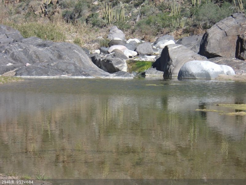
In the morning I decide to try La Rabia which turns out to be the wrong decision. It is a narrow canyon with large boulders all the way to the first
of several 'oasis' along it's length. There are a dozen or more Palm Trees and an area that has water year round.
Lucky for me I find a side trail since the creek bed looks damn near impassable through here. The trail leads up the west side and fairly quickly
climbs several hundred feet above the wash were it peters out and I lose it for good.
I push through the vegetation along the steep hillside until I am 250 feet above the creek bed.
I see no choice but to slowly work my way back down to the wash and try to follow it. After sometime I make it through to come upon a second 'oasis'
where I break for lunch and ponder my next move.

I am in section with room-sized boulders of granite and it takes the rest of the day to cover the miles to the upper reaches of the wash.
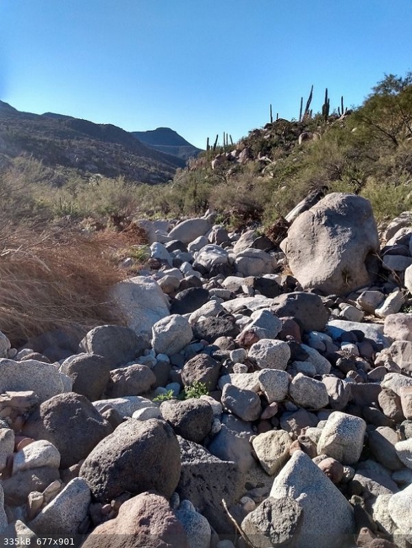

I have to climb over, under, and around boulders. Way to often I reach an impassable section that forces me to backtrack and find and alternate route.
After one final challenging section La Rabia finally starts to level out some what and I camp near where the tie trail crosses a low pass over to San
Sebastian.
I barely covered 6 miles in a long and arduous day of hiking, and went to sleep dreaming of easier trails tomorrow, and dreams were all they were.
Day 3 started with a quick detour to the saddle in between La Rabia and San Sebastian where I cached a few things.
Then for the first time I was on a trail that continued on and on. For miles through a pass into a large valley. Crossing the valley I came across
some horses and continued on to the pass at the far side of valley which then lead to another large valley.
The trail climbed down the pass in to this second valley and continued on to a third pass, where it petered out.
It was lunch time so finding a nice place to kickback and happy with the progress I had made so far today I pulled out the GPS.
With a little shock I realized I was in the wrong drainage and was over a mile away from where I should have been.
Torn between just turning around and heading back and trying to cross over the ridge to the trail I sat there slightly dejected.
I decided I would try to cross the ridge and get back on the trail. I climbed a 100 feet or so and started traversing across the steep hillside. The
hill was steep and full of loose rocks and cacti.
Halfway across a bee flew and became tangled in my glasses and stungme above my right eyebrow.
Normally a bee sting would not worry me EXCEPT….
Last July I was stung by a bee at work and a few minutes later I started feeling a little dizzy. Then my vision started fading, so I sat down to let
it pass.
After a few minutes I stood up, took two steps and passed out. I ended up waking up in the ambulance with a paramedic saying over and over again to
his partner he had never seen a blood pressure so low.
It all turned out well but here, miles from were I should be, far from any help it may not turn out so well.
Was I feeling off now because I was a little dehydrated, hiking in the full sun in the desert?
Or was I feeling off because of the bee sting?
Gonna have to leave it there for now.... will try to get a part 3
Read Part 1 here
Read Part 3 here
Read Part 4 here
[Edited on 1-17-2023 by Fatboy]
|
|
|
Barry A.
Select Nomad
Posts: 10007
Registered: 11-30-2003
Location: Redding, Northern CA
Member Is Offline
Mood: optimistic
|
|
Fatboy------Beautiful pictures-------great story---------cool hiking/exploring post. This is what Baja Nomad is all about!! (-:
|
|
|
Fatboy
Senior Nomad
Posts: 711
Registered: 6-28-2005
Member Is Offline
|
|
Thanks! I appreciate that...
|
|
|
David K
Honored Nomad
Posts: 64476
Registered: 8-30-2002
Location: San Diego County
Member Is Offline
Mood: Have Baja Fever
|
|
Just crazy what drives us to follow the mission road.
I wonder if Arroyo La Rabia once had a sand floor and after the 260 years since it was made the Royal Road, the sand washed away leaving only
boulders?
The Benchmark Atlas does not name La Rabia, but the older Baja Almanac does...
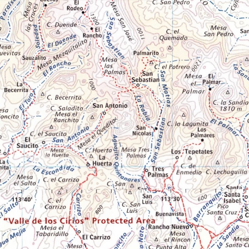
Los Corrales (mentioned in Part 1) isn't included, but is by the San Luis on this map. The ECR goes from Rancho Nuevo to San Luis to Tres Palmas to
near San Nicolas and then enters La Rabia... eventually going to El Rodeo at the top of this map.
|
|
|
David K
Honored Nomad
Posts: 64476
Registered: 8-30-2002
Location: San Diego County
Member Is Offline
Mood: Have Baja Fever
|
|
Here are Harry Crosby's ECR maps of this region (1974 & 1977):
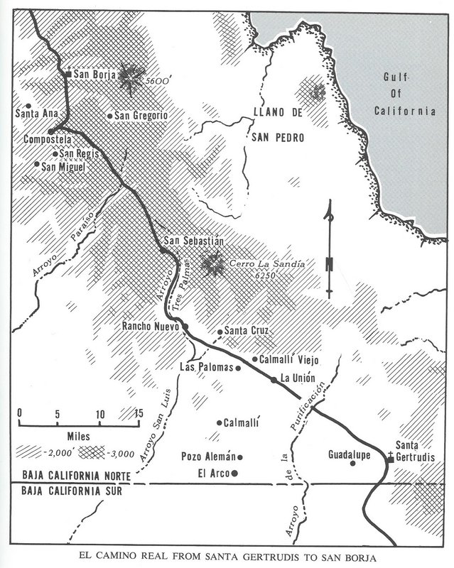
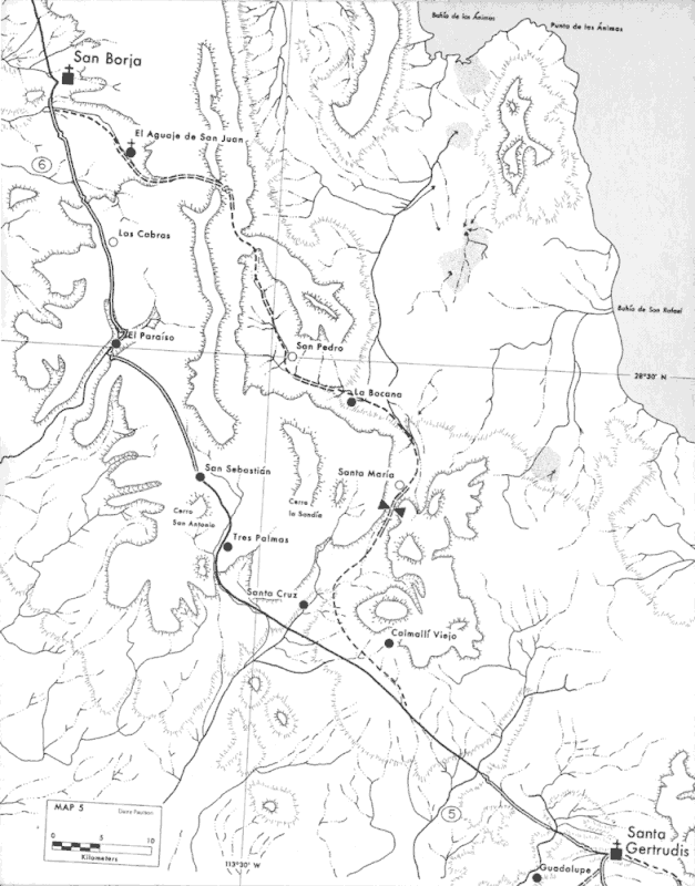
Looks like he may have stayed in Arroyo San Sebastian?
On the second (1977) map, a double line is where the mission road is cleary seen and a single line is the route, but not a well-preseved section of
road.
The dashed lines are alternnate ECR routes. Here, the famed Golfo Camino Real section, made famous in books by 20th Century explorers Arthur North
(1906) and Erle Stanley Gardner (1966).
|
|
|
Fatboy
Senior Nomad
Posts: 711
Registered: 6-28-2005
Member Is Offline
|
|
Yes, Crosby stayed in the 'main' wash to San Sebastian. Also the trail show along side of La Rabia is pretty close to what I did so it looks like even
then the bypassed a large section of the lower portion of the drainage.
It is a pretty narrow drainage so any trail was on a hillside and while I was on the trail on the lower part I either lost it or it was washed away
further up the canyon and I was faced withbeither turning around or bushwacking through the thorns.
I picked the thorns.
|
|
|
Fatboy
Senior Nomad
Posts: 711
Registered: 6-28-2005
Member Is Offline
|
|
I really wanted to walk a cleary defined section (Harry's double line section) and I felt that once up on the mesa past San Sebastian I would find it.
Now your map confirms my belief and to know that I was sooooo close almost makes me sad.
|
|
|
4x4abc
Ultra Nomad
Posts: 4163
Registered: 4-24-2009
Location: La Paz, BCS
Member Is Offline
Mood: happy - always
|
|
Quote: Originally posted by Fatboy  | I really wanted to walk a cleary defined section (Harry's double line section) and I felt that once up on the mesa past San Sebastian I would find it.
Now your map confirms my belief and to know that I was sooooo close almost makes me sad. |
you are one of the few who really do things most only talk about.
I take my hat off for you!
Did you record a track?
If so, I would love to see it.
Harald Pietschmann
|
|
|
David K
Honored Nomad
Posts: 64476
Registered: 8-30-2002
Location: San Diego County
Member Is Offline
Mood: Have Baja Fever
|
|
| Quote: Originally posted by Fatboy | I really wanted to walk a cleary defined section (Harry's double line section) and I felt that once up on the mesa past San Sebastian I would find it.
Now your map confirms my belief and to know that I was sooooo close almost makes me sad. |
Many years ago, here on Nomad, I made a series of posts showing ECR on Google Earth, in sections. They are still here on Nomad, but the Photobucket
watermark now soils them a bit.
What I suggest, is to use Google Earth and see the trail, at least where you can, easily. Up on the mesas and across the flat desert, it is quite
clear. In person, there will be brush trying to hide it at ground level. You can take GPS readings from key points of the trail (on your PC/ Google
Earth screen) and use that to find it on the ground. [info is for everyone, I am sure Fatboy is well versed]
CaminoRealBaja.com has done that. They have both waypoint pins with an * and without. The * means they see the trail on the ground there (same as
Harry's double lines). The ones without the * means it is the logical route without ground signs (Harry's single lines).
Harry made notes, mainly on the initial 1967 ride north (which he didn't begin until Comondú), but returned to supplement in years later. The couple
at CaminioRealbaja.com (Kevin and Genevieve) are fare more meticulous in seeking the original Jesuit routes.
Here they are near Mission Santa Gertrudis:
|
|
|
Fatboy
Senior Nomad
Posts: 711
Registered: 6-28-2005
Member Is Offline
|
|
[/rquote]
you are one of the few who really do things most only talk about.
I take my hat off for you!
Did you record a track?
If so, I would love to see it.[/rquote]
Thanks!
I do have a track on my Garmin gps I will download for Google Earth later tonight.
I also used Gaia on a smart phone, which some here swear by, but it would randomly quit recording the track so it is very incomplete.
|
|
|
4x4abc
Ultra Nomad
Posts: 4163
Registered: 4-24-2009
Location: La Paz, BCS
Member Is Offline
Mood: happy - always
|
|
| Quote: Originally posted by Fatboy |
I do have a track on my Garmin gps I will download for Google Earth later tonight.
I also used Gaia on a smart phone, which some here swear by, but it would randomly quit recording the track so it is very incomplete.
|
I stopped recording on Garmin a few years ago.
I find GaiaGPS on my phone more accurate and more reliable than any of my Garmins ever were.
Data ttransfer to the computer is much easier on the phone too.
Harald Pietschmann
|
|
|
Fatboy
Senior Nomad
Posts: 711
Registered: 6-28-2005
Member Is Offline
|
|
I think it goes back to use, for off trail hiking use on multi day trips a dedicated GPS is more reliable, though less user friendly.
In a vehicle I would use GAIA without A doubt.... You always have power available ... You can leave it in a dash mount, which means it is not always
being touched and awakened.
In my case it is in power saving mode as much as possible, it is often coming in and out of pockets where the screen may be pressed, it is being
switched between camera and GAIA which may result in it stopping the record and once in your pocket you don't realize it.
|
|
|
advrider
Super Nomad
Posts: 1847
Registered: 10-2-2015
Member Is Offline
|
|
Good report, 6 miles of that rocky hell is a long day. That stuff just zaps your energy and recks your body.
|
|
|


