| Pages:
1
2
3
4 |
David K
Honored Nomad

Posts: 64476
Registered: 8-30-2002
Location: San Diego County
Member Is Offline
Mood: Have Baja Fever
|
|
1860s Baja California Map Chat

I am calling it the '1860s' map (for now), as it uses leagues (something that was being phased out, starting in the late 1850s) , and is after the
Gadson Purchase of 1853.
Full size image: 1860s Baja California Map (Large)
[Edited on 1-17-2023 by David K]
|
|
|
David K
Honored Nomad
Posts: 64476
Registered: 8-30-2002
Location: San Diego County
Member Is Offline
Mood: Have Baja Fever
|
|
The map was on Facebook... no other data provided
I chatted with the person who posted it on Facebook, and he had no additional details for me to include here. It was interesting, it was historic, and
it deserves being seen more, 150 years later.
|
|
|
David K
Honored Nomad
Posts: 64476
Registered: 8-30-2002
Location: San Diego County
Member Is Offline
Mood: Have Baja Fever
|
|
This looks to be where the map was first posted and shared around, from yesterday (Jan. 16, 2023): https://www.facebook.com/ahensenadabc
It has nothing to do with the post, about Baja California statehood, and it says nothing about the map.
Edit: I just messaged the host of that page asking for more details on the map he posted yesterday.
[Edited on 1-18-2023 by David K]
|
|
|
bajaric
Senior Nomad
Posts: 600
Registered: 2-2-2015
Member Is Offline
|
|
Hmmmm. 1860's? That would sort of make sense, because it does not show Real del Castillo, a town that became the capital of the northern territory
of Baja in 1872. So that makes it pre-1872. No self-respecting cartographer would leave out the capital.
On the other hand, there are a couple of odd things. For one it uses the modern spelling of Tijuana. In the 1860's it was Rancho Tia Juana, a tiny
ranch hardly even worth noting on a map. It was not until 1874 that a customs house was established at Rancho Tia Juana to levy customs duties on
miners that were going to Real del Castillo and it became a "place". Not sure when it became known as Tijuana, but it was after then.
Also, shows a trail from Mission Santa Maria to San Felipe. As far as I know there was no such trail, ever. ?? Even if it meant to show the trail
from Puertecitos to Gonzaga I do not think such a trail existed in the 1880s, at least one that was in general use. That trip was considered a
life-threatening journey until after 1900, and seldom attempted by land. Back then, the few travelers to the Calamjue / Gonzaga coastline would make
the trip on a steamship or sailing vessel or from the west off the old mission trail, not from San Felipe.
And what was "Santa Isabel"? south of San Felipe. The lost mission?
Bit of a mystery. Perhaps a map drawn later to show early Baja? These are my thoughts.
|
|
|
mtgoat666
Select Nomad
Posts: 17280
Registered: 9-16-2006
Location: San Diego
Member Is Offline
Mood: Hot n spicy
|
|
Quote: Originally posted by David K  | | I chatted with the person who posted it on Facebook, and he had no additional details for me to include here. It was interesting, it was historic, and
it deserves being seen more, 150 years later. |
| Quote: Originally posted by David K | This looks to be where the map was first posted and shared around, from yesterday (Jan. 16, 2023): https://www.facebook.com/ahensenadabc
It has nothing to do with the post, about Baja California statehood, and it says nothing about the map.
Edit: I just messaged the host of that page asking for more details on the map he posted yesterday.
[Edited on 1-18-2023 by David K] |
The fb post you linked indicates the map came from La Mapoteca Manuel Orozco y Berra de Tacubaya. Googling this,place, it seems kind of cool. I am
surprised a map guy like you has not visited the mapoteca. Flights to DF are cheap, DK, go visit the mapoteca and come back with some baja history.
Not sure you method of dating (based on “leguas”) is sound.
[Edited on 1-18-2023 by mtgoat666]
[Edited on 1-18-2023 by mtgoat666]
Woke!
“...ask not what your country can do for you – ask what you can do for your country.” “My fellow citizens of the world: ask not what America
will do for you, but what together we can do for the freedom of man.”
Prefered gender pronoun: the royal we
|
|
|
David K
Honored Nomad
Posts: 64476
Registered: 8-30-2002
Location: San Diego County
Member Is Offline
Mood: Have Baja Fever
|
|
I got a reply from the owner of that page.
Will post the English translation soon.
*See below...
[Edited on 1-18-2023 by David K]
|
|
|
David K
Honored Nomad
Posts: 64476
Registered: 8-30-2002
Location: San Diego County
Member Is Offline
Mood: Have Baja Fever
|
|
From the Facebook group host, about that map:
Hola David. El mapa pertenece a la Mapoteca Orozco y Berra. Ellos tienen en línea una buena colección de mapas. En el caso de éste, lo publicaron
sin fecha pero yo creo que es anterior a 1875
Hi David. The map belongs to the Mapoteca Orozco y Berra. They have a good collection of maps online. In the case of this one, they published it
without a date but I think it is before 1875
>>> So, I am still okay with calling it an 1860s map! 
|
|
|
David K
Honored Nomad
Posts: 64476
Registered: 8-30-2002
Location: San Diego County
Member Is Offline
Mood: Have Baja Fever
|
|
| Quote: Originally posted by bajaric | Hmmmm. 1860's? That would sort of make sense, because it does not show Real del Castillo, a town that became the capital of the northern territory
of Baja in 1872. So that makes it pre-1872. No self-respecting cartographer would leave out the capital.
On the other hand, there are a couple of odd things. For one it uses the modern spelling of Tijuana. In the 1860's it was Rancho Tia Juana, a tiny
ranch hardly even worth noting on a map. It was not until 1874 that a customs house was established at Rancho Tia Juana to levy customs duties on
miners that were going to Real del Castillo and it became a "place". Not sure when it became known as Tijuana, but it was after then.
Also, shows a trail from Mission Santa Maria to San Felipe. As far as I know there was no such trail, ever. ?? Even if it meant to show the trail
from Puertecitos to Gonzaga I do not think such a trail existed in the 1880s, at least one that was in general use. That trip was considered a
life-threatening journey until after 1900, and seldom attempted by land. Back then, the few travelers to the Calamjue / Gonzaga coastline would make
the trip on a steamship or sailing vessel or from the west off the old mission trail, not from San Felipe.
And what was "Santa Isabel"? south of San Felipe. The lost mission?
Bit of a mystery. Perhaps a map drawn later to show early Baja? These are my thoughts. |
Often maps included rumors or hear-say to dress it up.
Santa Isabel was the water source included on the Jesuit maps. Today a sierra has its name. The water source may have been Agua del Mezquitito (just
south of Okie Landing).
I did find the Tijuana part very out-of-place!
|
|
|
mtgoat666
Select Nomad
Posts: 17280
Registered: 9-16-2006
Location: San Diego
Member Is Offline
Mood: Hot n spicy
|
|
The Mapoteca has a FB https://www.facebook.com/mmoyb.siap.gob.mx
I get a 403 forbidden result from the mapoteca website when trying to look at https://mapoteca.siap.gob.mx/
perhaps the website blocks viewers (IP addresses) from outside of mexico?
Woke!
“...ask not what your country can do for you – ask what you can do for your country.” “My fellow citizens of the world: ask not what America
will do for you, but what together we can do for the freedom of man.”
Prefered gender pronoun: the royal we
|
|
|
BajaTed
Senior Nomad
Posts: 859
Registered: 5-2-2010
Location: Bajamar
Member Is Offline
|
|
As on all of the old maps of that show the border, I have always wondered why the Colorado River has the border transecting the river with a
north/south deviation?
Es Todo Bueno
|
|
|
mtgoat666
Select Nomad
Posts: 17280
Registered: 9-16-2006
Location: San Diego
Member Is Offline
Mood: Hot n spicy
|
|
| Quote: Originally posted by BajaTed | | As on all of the old maps of that show the border, I have always wondered why the Colorado River has the border transecting the river with a
north/south deviation? |
because CA/Mex border was established when usa acquired CA about 1848 following war.
the AZ/Mex border came out of the Gadsen purchase about 1854.
Woke!
“...ask not what your country can do for you – ask what you can do for your country.” “My fellow citizens of the world: ask not what America
will do for you, but what together we can do for the freedom of man.”
Prefered gender pronoun: the royal we
|
|
|
David K
Honored Nomad
Posts: 64476
Registered: 8-30-2002
Location: San Diego County
Member Is Offline
Mood: Have Baja Fever
|
|
Very good answer, goat!
|
|
|
David K
Honored Nomad
Posts: 64476
Registered: 8-30-2002
Location: San Diego County
Member Is Offline
Mood: Have Baja Fever
|
|
4x4abc asked about Santa Isabel on the map...
The name, Santa Isabel, was given to a water source discovered by Padre Consag, in 1746 (during his sea expedition along the coast, to the Colorado
River).
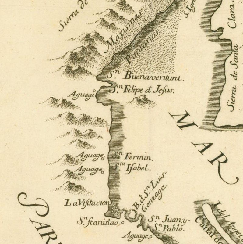
Many names we use today were created by Padre Consag, during his 1746 expedition. This map was published the following year.
Aguge is a water source for ships in need, to come ashore for. In the 1700s, what looks like the small letter f (in the middle of a word) was
common for the sound of s.
These names and features were repeated on the well-known Jesuit map, published in 1757 (but shows missions as they were ten years earlier).
1757 Jesuit Map
When looking for a possible lost mission location, beyond Santa María, this may have been the source of the name. Today, the low mountain range in
the area along the gulf has the name Santa Isabel, and on the AAA map, a point near El Huerfanito.

The area between El Mármol and Matomí has been the most popular region to search of the Lost Mission of Santa Isabel.
|
|
|
mtgoat666
Select Nomad
Posts: 17280
Registered: 9-16-2006
Location: San Diego
Member Is Offline
Mood: Hot n spicy
|
|
| Quote: Originally posted by David K | | The name, Santa Isabel, was given to a water source discovered by Padre Consag, in 1746 (during his sea expedition along the coast, to the Colorado
River). |
DK:
a clarification....
The Padre did not "discover" the water source. Surely the indigenous peoples had discovered it, and I suspect the indigenous peoples had a name for
that water source location. The Padre just named it for his own purposes.
No geographic features in north america were "discovered" by colonists. The colonists just appropriated and named things already known and often
named by the original peoples.
Woke!
“...ask not what your country can do for you – ask what you can do for your country.” “My fellow citizens of the world: ask not what America
will do for you, but what together we can do for the freedom of man.”
Prefered gender pronoun: the royal we
|
|
|
David K
Honored Nomad
Posts: 64476
Registered: 8-30-2002
Location: San Diego County
Member Is Offline
Mood: Have Baja Fever
|
|
You don't think we all know that?
Yes, a Native may have (likely have) showed the padre the spring. Let me read Consag's diary and see if there is more to learn... stay tuned.
"Discovered" (in this case) by European explorers, who had a written language that allowed anyone in the future to identify a location by.
Do you live in San Diego or a name used by the Kumeyaay... a name lost to time?
A common practice for naming locations was to use the saint for that day of discovery.
|
|
|
mtgoat666
Select Nomad
Posts: 17280
Registered: 9-16-2006
Location: San Diego
Member Is Offline
Mood: Hot n spicy
|
|
| Quote: Originally posted by David K | You don't think we all know that?
Yes, a Native may have (likely have) showed the padre the spring. Let me read Consag's diary and see if there is more to learn... stay tuned.
"Discovered" (in this case) by European explorers, who had a written language that allowed anyone in the future to identify a location by.
Do you live in San Diego or a name used by the Kumeyaay... a name lost to time?
A common practice for naming locations was to use the saint for that day of discovery. |
Just seems silly to say that Columbus "discovered" the new world. People and large/advanced civilizations had been living in the new world thousands
of years before Columbus stumbled onto the scene.
Don't buy into the euro-centric view of history!
Woke!
“...ask not what your country can do for you – ask what you can do for your country.” “My fellow citizens of the world: ask not what America
will do for you, but what together we can do for the freedom of man.”
Prefered gender pronoun: the royal we
|
|
|
David K
Honored Nomad
Posts: 64476
Registered: 8-30-2002
Location: San Diego County
Member Is Offline
Mood: Have Baja Fever
|
|
Again, we know that.
European discovery is what was mentioned, not human discovery. Only European discoveries here have names and dates. Before you counter that, yes,
there are Chinese monks who told of a far away land that very well could have been Baja California.
Can we get back to discussing this map's contents?
|
|
|
David K
Honored Nomad
Posts: 64476
Registered: 8-30-2002
Location: San Diego County
Member Is Offline
Mood: Have Baja Fever
|
|
I did not see a mention of Santa Isabel in Padre Consag's diary. The part from San Luis Gonzaga to San Fermin (just north of Puertecitos) is on pages
71-74: https://archive.org/details/lifeworksofrever00kons/
|
|
|
David K
Honored Nomad
Posts: 64476
Registered: 8-30-2002
Location: San Diego County
Member Is Offline
Mood: Have Baja Fever
|
|
Another weird thing on the 1860s map is the showing of a sizable town called Santiago, just northwest of Mulegé. It is on the coast, or close...
about where today's San Bruno is. If it was inland, I would guess it to be a mis labeled Boca de Magdalena or San José de Magdalena.
Just examined all the maps from the 1800s at www.vivabaja.com/maps and found no place called Santiago in that area.
|
|
|
4x4abc
Ultra Nomad
Posts: 4163
Registered: 4-24-2009
Location: La Paz, BCS
Member Is Offline
Mood: happy - always
|
|
add Santa Ana north of San Borja instead of south and you know it is questionable map
as I said before - Gulick had the first accurate maps of Baja
Harald Pietschmann
|
|
|
| Pages:
1
2
3
4 |


