David K
Honored Nomad

Posts: 64478
Registered: 8-30-2002
Location: San Diego County
Member Is Offline
Mood: Have Baja Fever
|
|
1947 Auto Club Report on the drive to the tip.
Perhaps because of WWII, there doesn't seem to be much action in Baja from the Automobile Club of Southern California from the late 1930s to the
1950s?
In the 1930s, with permission of the peninsula's Mexican government, the Auto Club of Southern California installed road signs with distances along
main dirt roads. They also made a map and a road log in 1930, plus maps in 1934 and 1936.
Around 1940, the U.S. believed the Japanese may have had or at least planned a submarine base in Magdalena Bay and secret runways in Baja, in order to
swiftly attack California! I have posted the publications about that in this forum, a while back.
After the war ended (Summer of 1945), and things got normal, a huge surplus of Army Jeeps and Power Wagons were available, plus Willys-Overland began
making 'civilian Jeeps' or CJs as well as 4-whee-drive wagons and pick ups. People wanted to get back to enjoying life, traveling, hunting, and
fishing. Baja (Lower) California seemed to be perfect for taht, with the creation of 4-wheel-drive vehicles.
A member of the Automobile Club of Southern California wrote a detailed letter about the drive south. The club reproduced that letter for members. It
makes for some very interesting reading of what a drive down the peninsula was like. This would have been the year Erle Stanley Gardner traveled the
first time, down the peninsula and wrote his 1948 book, The Land of Shorter Shadows.
Between Erle's book and the Auto Club letter, we have a good look at Baja travel in 1947.
With help from another Nomad, I have made a web page with an enhanced copy of the letter [with a few typo corrections and notes, added], plus a 1949
photo of an Auto Club sign (taken just south of San Quintín) and links to all the Auto Club (AAA) maps I have been able to preserve, so far:
https://vivabaja.com/1947-auto-club-trip-report/
Here is a sample paragraph:
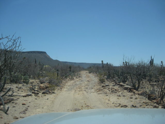
Approaching Comondú, the road runs to the edge of a mesa. Far below at the foot of the steep mountain nestles the village. This grade is
as bad as any encountered. This settlement is two in one [San José & San Miguel], watered like Mulegé and San Ignacio by natural springs.
Heading south out of Comondú the road runs through large groves of mesquite in a magnificent narrow canyon with the rocky walls towering up for a
thousand feet. During the morning, we encountered our first sand troubles. A truck with larger tires and wider between the wheels would not have as
difficult going.
|
|
|
4x4abc
Ultra Nomad
Posts: 4163
Registered: 4-24-2009
Location: La Paz, BCS
Member Is Offline
Mood: happy - always
|
|
best trip report I have seen in years
Harald Pietschmann
|
|
|
bajafreaks
Nomad
Posts: 398
Registered: 3-27-2007
Location: Gardnerville, NV./ Los Barriles BCS
Member Is Offline
Mood: No Bad Days !!!
|
|
Good read, thanks.
|
|
|
mtgoat666
Select Nomad
Posts: 17289
Registered: 9-16-2006
Location: San Diego
Member Is Offline
Mood: Hot n spicy
|
|
Very timely trup report. Thank you!
Woke!
“...ask not what your country can do for you – ask what you can do for your country.” “My fellow citizens of the world: ask not what America
will do for you, but what together we can do for the freedom of man.”
Prefered gender pronoun: the royal we
|
|
|
David K
Honored Nomad
Posts: 64478
Registered: 8-30-2002
Location: San Diego County
Member Is Offline
Mood: Have Baja Fever
|
|
Timely? This is the Historical Interests & Literature forum.
Trup? oh, never mind... 
|
|
|
Alan
Super Nomad
Posts: 1617
Registered: 4-6-2005
Location: Yucaipa, CA/La Paz
Member Is Offline
|
|
It was the old AAA guidebooks that piqued my imagination and thus started my love of the peninsula 50 years ago. So sad to see them go to the wayside
but that is as all things..
In Memory of E-57
|
|
|
bajaric
Senior Nomad
Posts: 602
Registered: 2-2-2015
Member Is Offline
|
|
It says:
"There are two roads south of Punta Prieta that join again some fifty miles away. One follows down the peninsula, the other swings along the Pacific.
We took the latter as it was said to be smoother. It had majestic scenery as we wandered through deep canyons towards the Ocean".
Must have been a coastal route that went down the coastline and rejoined the main highway pretty far to the south. The first leg of that coastal
route was probably an earlier wagon road that went from Punta Prieta to a landing at Santa Rosalillita, 23 miles south. This road had gone in to
supply mining activities near Punta Prieta around 1900. The mines were supplied by sea, as there was no north / south route then other than the old
burro trail of the padres and cattle trails between ranchos. Many of the early roads in central Baja started out in this way, as wagon roads from
landings on the coastline to mines in the interior. As time progressed some of these roads were incorporated into the north / south route down the
entire peninsula.
On a related note, the arrow-straight road south of El Arco to me looks like the work of El Boleo. El Boleo, the French owned mining company, took
over copper mining at El Arco in the 1940's until mining was abandoned in 1948.
[Edited on 2-2-2023 by bajaric]
|
|
|
David K
Honored Nomad
Posts: 64478
Registered: 8-30-2002
Location: San Diego County
Member Is Offline
Mood: Have Baja Fever
|
|
Very nice reply, Ric... Yes, Boleo did a lot of road building, mostly to their many cattle ranches and farms... all to produce food for their miners
and the company town (Santa Rosalia).
Their road (or maybe first road) was to the east a bit, and went to the ranch 'casona' we call Prosperidad. Just a small section of their straight/
engineered road is visible... Maybe Harald tracked more of it than I could see on the ground and Google Earth. I imagine it continued on to the casona
of San Miguel, by the coast, south of El Barril??
I have not been to San Miguel, but others here (Harald, TMW, The squarecircle, and geoffff) have, and photographed it.
On my website, I have photos of the one at Prosperidad, with these captions (in 2017 and again in 2019):

Ruin of Prosperidad, north-east side. The year 1916 is over a doorway. The style indicates construction by the French Copper Mine company, Boleo. They
established many ranches to provide for the food needed in Santa Rosalía.
Old-old road southbound from Prosperidad.

Back to Prosperidad, the south side. The brick building is called a casona. See more photos here in this photo page: https://octopup.org/baja2014/gertrudis
2019:

The casona (large house) at Prosperidad built for the Boleo/Santa Rosalia mine workers as a cattle ranch.
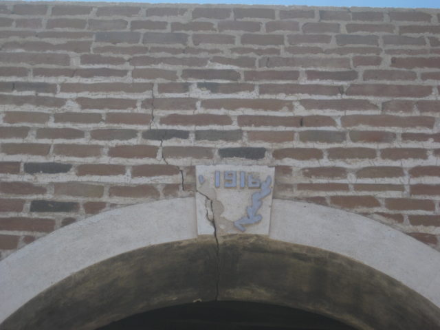
1916
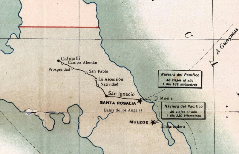
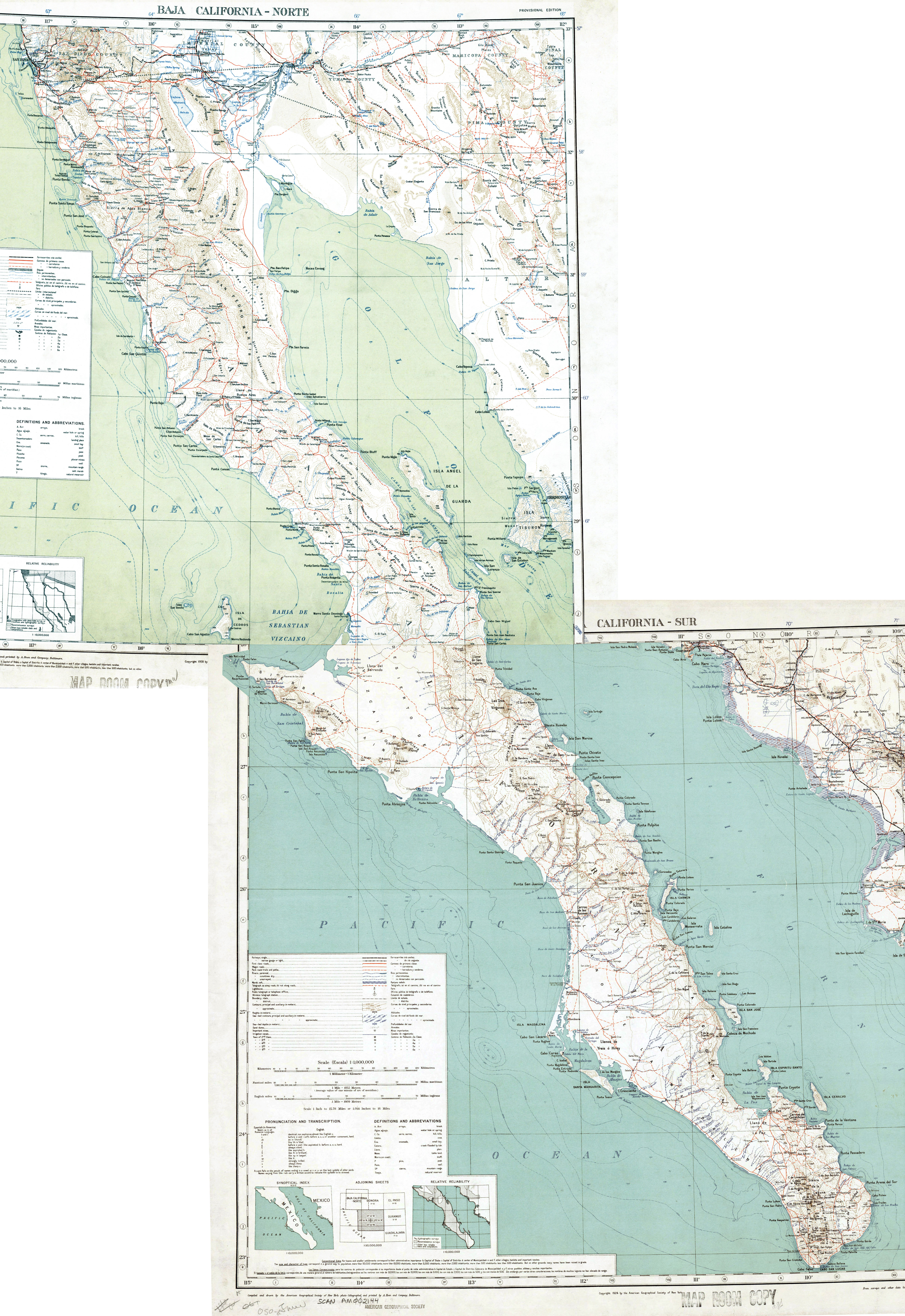
In 1904, on the Postal Route Map (not too accurate with directions or distances), we see Prosperidad.
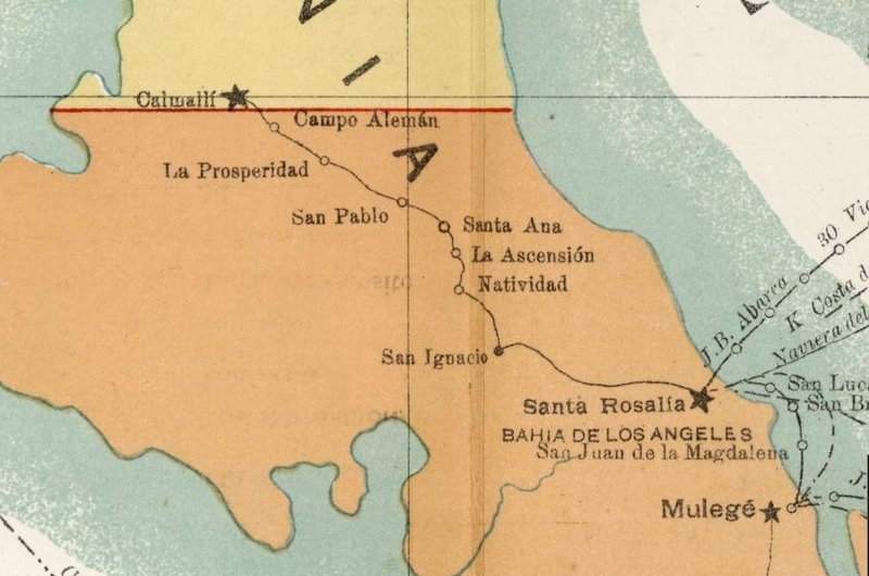
On the 1908 map, they at least moved Calmallí north of the border between territories!
The straight road alignment is shown on this 1924 south/ 1928 north map: 1920s Baja California map
Prosperidad is shown as Pozo Altamirano... just north of Arroyo San Pablo.
El Arco doesn't exist on maps until 1930. The area commercial gold mining began around 1883 in Calmallí. By 1910, more activity is seen at Pozo
Alemán. In the late 1920's to 1930. the gold miners moved southward, again to establish El Arco (the rainbow) where they hoped to find the pot of
gold!
Seems there is also copper in the area (first mentioned along with the gold in 1959 book). Since the 1970s, the future large copper mining has been
mentioned and recently, talk of a giant open pit copper mine that may be the world's largest! Still nothing and the town is deserted but for one
cattle ranch now set up there.
|
|
|
bajaric
Senior Nomad
Posts: 602
Registered: 2-2-2015
Member Is Offline
|
|
Regarding the "arrow straight road' south of El Arco I was looking at Gerhard and Gulik's map. This appears to be the same road shown on the 1928 map
linked above, as both maps show the road going past El Caracol enroute to San Ignacio.
This sort of pokes a hole in my theory that El Boleo built that road to haul copper ore from El Arco to Santa Rosalia, as El Arco did yet exist in the
1920s.
Nonetheless, most of the mines at El Arco were copper mines. This is a question of semantics, as copper ore does sometimes contain gold.
The difference between a "gold mine" and a "copper mine" is that the ore at a gold mine is "free milling", that is, the gold can be recovered by
simply crushing the ore and washing it with water. The ore at a copper mine is "refractory ore" meaning that the copper and other metals in the ore
can only be recovered after "roasting", that is, smelting it in a blast furnace. Copper ore does sometimes contain gold, as at Cedros Island, but it
must be smelted to recover the gold.
Calmalli was a bona fide gold mining boom town from about 1883-1900. The free milling gold was found in veins of quarts, as was typical of gold mines
in both Alta and Baja California. The gold ore was crushed in stamp mills on site. The district produced an estimated 130,000 ounces of gold during
this period, including placer deposits. In later years the ore mined at Calmalli deteriorated into a complex gold-bearing copper ore, as noted in the
1908 copper handbook, before mining was abandoned around 1910. (Copper ore is generally greenish in color and does not ordinarily contain visible
gold). Like El Arco, the town lived on as an outpost of civilization in the central desert after the mines shut down until it was totally abandoned a
couple of decades later.
At any rate, there are a number of indications that the main mining activity at El Arco was copper mining. For one, it is highly unlikely that the
gold miners at Pozo Aleman in the 1890's would have failed to notice a major deposit of free milling gold ore in quartz veins just a few miles to the
south, leaving it undiscovered until the 1930's.
For two, Gulik said that at one point there were 2,000 "gold miners" employed at El Arco. If that number is accurate this is more typical of a copper
mining effort, where the ore was mined in large quantities due to its relatively low value compared to gold. Gold mines generally required a much
smaller labor force than copper mines. The efforts of a couple dozen men was enough to operate a fairly large gold mine. Indeed, the total
population of Calmalli at its peak was just 400 persons, wives and children included and that small population was enough to produce 130,000 ounces of
gold.
A mining effort that employed 2,000 miners mining free milling gold ore in quartz veins would have gone down in history as a huge gold strike. Such
an effort would be expected to yield a half a million ounces of gold, on par with the largest lode gold mines in Alta California. And yet El Arco is
barely mentioned in the contemporary mining journals.
Finally, the modern geological reports and show most if not all of the historic mines and mineral deposits (pre-1970) around El Arco as copper / gold
mines, or metavolcanic iron / copper mineral deposits. El Rebaje, a huge mine visible on Google Earth between Pozo Aleman and Calmalli, for example,
was a copper mine.
The 1930 AAA road guide (which did not even get the right location for El Arco) statement that "100 men are employed at El Arco in the mining of gold"
was probably just an error, passed down from travel guide to travel guide since then, including by Gerhard and Gulik, Minch, and many others. It just
sounds more exciting and romantic than saying "100 men were employed at El Arco in the mining of copper."
All this does not rule out that El Boleo had a hand in the construction of the road south of El Arco. It might have been a ranch road, or they could
have had some interest in mining at Pozo Aleman or Calmalli. As noted, gold-bearing copper ore was mined at Calmalli after 1905 and similar ore may
have been encountered at Pozo Aleman. Refractory gold and silver bearing ore was delivered to Santa Rosalia for smelting from as far away as La Paz.
El Boleo, of course, would have welcomed such deliveries from Calmalli, Pozo Aleman, and later, El Arco. If anyone could squeeze a little gold out of
some copper ore it was the Rothschilds. Being copper miners, El Boleo employed 3,000 men during the period. They had ample resources to construct
such a road to replace the old mission burro trail that went through the mountains.
As far as the future of El Arco, the "porphyry" copper deposit discovered there in the 1970's is a different type of ore than was mined in the 1930's.
It is a very large ore body (800 million tons) spread out over a vast area containing small amounts of copper. However, in a global economy it all
comes down to who can mine it the cheapest and at the largest scale. The low grade of the ore, lack of water, and remote location, perhaps, has
prevented mining from getting off the ground.
|
|
|
David K
Honored Nomad
Posts: 64478
Registered: 8-30-2002
Location: San Diego County
Member Is Offline
Mood: Have Baja Fever
|
|
Thank you, Ric!   
You may be right about gold mines being more flashy than copper!
Maybe Gulick (or Gerhard) was given false historical data about El Arco back in the early 1950s? Maybe it was a typo from 200 to 2000? However, I
don't rest on the word of just the 'Baja Bible' (Lower California Guidebook's nick name) as most every book I have calls it a gold mine town, and its
name would seem to attract or honor gold miners...??
It is just fun researching and pondering...
In this excellent book (#51 of the Dawson Series):

On page 175:
|
|
|
bajaric
Senior Nomad
Posts: 602
Registered: 2-2-2015
Member Is Offline
|
|
History is fun!
So, two fairly reliable sources (Guli8k, Modest Forturnes) said that El Arco was a "gold mining center" and 2,000 "gold miners" carried out mining
there in the 1930's. I did a little more research and ran across this report from Gupo Mexico: El Arco Project Technical Report Summary
https://www.sec.gov/Archives/edgar/data/1001838/000155837022...
Buried in the report are a couple of tidbits of El Arco mining history, including this:
"In 1883, gold placers were discovered in the Calmalli–El Arco district of Baja California. Lode and placer mining for gold has continued
sporadically to the present day, although the combined production has not been significant. During World Wars I and II, attention in the
district was focused on the oxidized copper minerals associated with the gold, and, although its remote location made production costly, a few small
operations were successful. The principal mines in the Calmalli–El Arco district were the Calmalli-Don Carlos mine, developed
in the early 1930s for gold and copper, and the El Arco mine, which operated from 1935 to 1940 with small gold bonanzas reported".
So, it appears that there WAS a little bona fide gold mining at El Arco, though the primary mineral they were after was copper. However, I think it
is safe to say that these small gold mining operations did not employ 2,000 gold miners. The largest gold mine in California, the Empire in Grass
Valley, employed 800 miners in the same time period (1940). This was a massive mine, with a huge mill that produced a million ounces of gold after
1900. There is no evidence that anything like the Empire mine was ever present at El Arco, much less two such operations.
I think Gulik and Modest Fortunes probably overestimated the total population of El Arco, the number of miners that worked there, and went along with
the conventional narrative that it was a gold mining town when the primary metal of interest at El Arco was copper. It would appear that there was a
little free-milling gold ore found there as well, processed on site with stamp mills. Nonetheless, if there were ever two thousand miners at El Arco,
the results of their efforts are probably in the slag heaps at Santa Rosalia.
The distinctly French looking architecture at La Prosperidad perhaps indicates that during WW1 the El Boleo company may have had some involvement and
constructed a road to access the town from Santa Rosalia and perhaps haul copper ore to its smelters. El Boleo actually took over mining at El Arco
in the 1940's.
With regards to the future of El Arco, if the Grupo Mexico project ever comes to fruition, El Arco is going to be a big hole in the ground.
|
|
|
David K
Honored Nomad
Posts: 64478
Registered: 8-30-2002
Location: San Diego County
Member Is Offline
Mood: Have Baja Fever
|
|
Super history in Baja!
How cool would it be to see how these roads and mines were made. There must be more photos somewhere. Ed Davis traveled all around Baja in 1926, but I
have only seen his photos of the people and the missions.
Just checked Margaret Bancroft's 1930s photo album... and nothing of El Arco; just Punta Prieta, Isla Cedros, El Mármol and other sites north. Links
in the Historic Photos section on VivaBaja.com.
|
|
|
|


