| Pages:
1
2 |
Bildo
Newbie
Posts: 12
Registered: 3-16-2023
Member Is Offline
|
|
Driving a Lincoln Towncar to Cabo
Hi all. I am thinking of driving a low mile Lincoln Towncar to Cabo next winter. I am in the planning stages and thought I would cross the border in
San Ysidro or Tecate. I was wondering what the best route was. I will need to find lodging. If I drive 12 hours in I would make to the San Ignacio
area. The next day we would be in the Cabo area.
Anyway, thanks for reading this post and for any good ideals.
Bill
|
|
|
mtgoat666
Select Nomad

Posts: 17284
Registered: 9-16-2006
Location: San Diego
Member Is Offline
Mood: Hot n spicy
|
|
Quote: Originally posted by lencho  | | Quote: Originally posted by Bildo | Hi all. I am thinking of driving a low mile Lincoln Towncar to Cabo next winter. I am in the planning stages and thought I would cross the border in
San Ysidro or Tecate. I was wondering what the best route was. I will need to find lodging. If I drive 12 hours in I would make to the San Ignacio
area. The next day we would be in the Cabo area.
Anyway, thanks for reading this post and for any good ideals.
Bill |
This first-time post has all the makings of a good troll, but I'll bite: 12-hour days in winter will have you driving in darkness, bad idea for a
Lincoln Towncar with a newbie at the wheel. |
Lincoln town car is safer than a Tacoma or jeep in a rollover or head on, so the OP should be relatively better off driving at night, compared to some
nomads.
[Edited on 3-17-2023 by mtgoat666]
Woke!
“...ask not what your country can do for you – ask what you can do for your country.” “My fellow citizens of the world: ask not what America
will do for you, but what together we can do for the freedom of man.”
Prefered gender pronoun: the royal we
|
|
|
David K
Honored Nomad
Posts: 64476
Registered: 8-30-2002
Location: San Diego County
Member Is Offline
Mood: Have Baja Fever
|
|
Using Hwy. 5 (Mexicali to Laguna Chapala, via San Felipe) is shorter, faster, easier, and less Mexico-mountain driving. Take I-8 east to the 111 south
(Calexico).
Option 1: A bit slower plus tolls (~US$10, total):
You can cross at Tecate, then get on the 2-D (toll) highway east. Well before Mexicali, the 2-D forks to the south and meets Hwy. 5 (signed for San
Felipe), south of the city of Mexicali.
Getting the FMM (tourist permit) is not as easy at Tecate because of the parking situation.
With a San Diego sunrise start, you can be in San Ignacio for dinner and a sunset walk along the river!
|
|
|
Marty Mateo
Nomad
Posts: 103
Registered: 12-7-2019
Location: Vanisle Sur
Member Is Offline
|
|
This was my ride back in 1993. A 68 Dodge Monaco, that I’d got for free a month before and only needed a new battery and front tires to get it back
on the road. My buddy ,his dog and myself had a great 10 week drive down from Canada and back. I’d suggest taking as much time as you can for the
drive, so many places to visit and of course all the beaches . We drove a lot dirt roads on that trip, even the old road out to Scorpion Bay.

|
|
|
Bildo
Newbie
Posts: 12
Registered: 3-16-2023
Member Is Offline
|
|
| Quote: Originally posted by David K | Using Hwy. 5 (Mexicali to Laguna Chapala, via San Felipe) is shorter, faster, easier, and less Mexico-mountain driving. Take I-8 east to the 111 south
(Calexico).
Option 1: A bit slower plus tolls (~US$10, total):
You can cross at Tecate, then get on the 2-D (toll) highway east. Well before Mexicali, the 2-D forks to the south and meets Hwy. 5 (signed for San
Felipe), south of the city of Mexicali.
Getting the FMM (tourist permit) is not as easy at Tecate because of the parking situation.
With a San Diego sunrise start, you can be in San Ignacio for dinner and a sunset walk along the river! |
Thanks. I had thought of burning a night in San Felipe or Ensenada as an original plan. I probably should do 2 nights like San Felipe for a night then
Loreto for a night. I did see a video about getting the FMM in Tecate. It looked like the office is right at the crossing. I didn't notice any
signage.
Is it easier to cross at Tijuana or Tecate ? Coming back we will be using the Sentri Lane.
Bill
|
|
|
Bildo
Newbie
Posts: 12
Registered: 3-16-2023
Member Is Offline
|
|
| Quote: Originally posted by lencho | | Quote: Originally posted by Bildo | Hi all. I am thinking of driving a low mile Lincoln Towncar to Cabo next winter. I am in the planning stages and thought I would cross the border in
San Ysidro or Tecate. I was wondering what the best route was. I will need to find lodging. If I drive 12 hours in I would make to the San Ignacio
area. The next day we would be in the Cabo area.
Anyway, thanks for reading this post and for any good ideals.
Bill |
This first-time post has all the makings of a good troll, but I'll bite: 12-hour days in winter will have you driving in darkness, bad idea for a
Lincoln Towncar with a newbie at the wheel. |
Aloha Lecho. I want to assure you that I'm not a troll. Years ago I was a member of this forum. I don't remember who I was or my email so I started a
new profile. I have driven between Loreto and Cabo maybe 4 times and La Paz to Cabo on both routes. In recent years we have been staying in the Puerto
Vallarta area and have drove to Mazatlan to Pv a couple of times.
I could drive an older Ford Expedition but it gets about 11 mpg compared to the old Towncar. The Expedition has over 200,000 miles on it compared to
45,000 on the Lincoln is one reason I like the Lincoln. The Lincoln is a way smoother ride and has plenty of room for our items if we stay in motels.
The Expedition is my off road camper.
Bill
|
|
|
David K
Honored Nomad
Posts: 64476
Registered: 8-30-2002
Location: San Diego County
Member Is Offline
Mood: Have Baja Fever
|
|
| Quote: Originally posted by Bildo | | Quote: Originally posted by David K | Using Hwy. 5 (Mexicali to Laguna Chapala, via San Felipe) is shorter, faster, easier, and less Mexico-mountain driving. Take I-8 east to the 111 south
(Calexico).
Option 1: A bit slower plus tolls (~US$10, total):
You can cross at Tecate, then get on the 2-D (toll) highway east. Well before Mexicali, the 2-D forks to the south and meets Hwy. 5 (signed for San
Felipe), south of the city of Mexicali.
Getting the FMM (tourist permit) is not as easy at Tecate because of the parking situation.
With a San Diego sunrise start, you can be in San Ignacio for dinner and a sunset walk along the river! |
Thanks. I had thought of burning a night in San Felipe or Ensenada as an original plan. I probably should do 2 nights like San Felipe for a night then
Loreto for a night. I did see a video about getting the FMM in Tecate. It looked like the office is right at the crossing. I didn't notice any
signage.
Is it easier to cross at Tijuana or Tecate ? Coming back we will be using the Sentri Lane.
Bill |
For sure, the INM desk is in that first building inside Mexico, as at the other borders. The problem is parking...
You can't park in front of it, as you can at other borders.
Some will park on the U.S. side, and walk to it for the FMM and then walk back into the U.S. to drive in.
OR, you drive a block south (past the first street cross street in Mexico, which is one-way, the wrong way) turn right (west), turn right again
(north), and turn right a third time (east) to came along the back side of the immigration building. There you will see parking spots, with cones
blocking them. It is said someone will move tyhe cones so you can park there to get your FMMs.
I found street parking before reaching that (another option, obviously). You then need to go through turnstyles, cross the road you drove on just
before, entering Mexico, and then walk in that building. Another turnstyle is how you get back to the street you are parked on.
|
|
|
Maderita
Senior Nomad
Posts: 634
Registered: 12-14-2008
Location: San Diego
Member Is Offline
|
|
Returning to the USA:
Tecate does not have a SENTRI lane. And that northbound crossing closes at 10:00 PM, sharp.
Otay Mesa has a SENTRI lane which closes at 10:00 PM, sharp. (Regular and Ready lanes are 24 hours).
San Ysidro has 24 hour SENTRI lanes.
https://bwt.cbp.gov/
|
|
|
RFClark
Super Nomad
Posts: 2330
Registered: 8-27-2015
Member Is Offline
Mood: Looking forward to 2024
|
|
David K is right.
Mexicali to San Felipe 2.5 hrs. San Felipe to San Ignacio around 6 hrs plus a one hr time change. Carry a good spare or better yet 2 as your tires
might be hard to find in Mexico. South of San Felipe there is no cell service until the 28th parallel. An iPhone with Sat emergency service or a sat
emergency locater is a good idea too! There is Internet service at Bahia Gonzaga and the restaurant at the 5/1 junction. Under no circumstances drive
after dark between Gonzaga and Jesus Y Maria. (There be Dragons!) There usually is gas (regular only) at Gonzaga during daylight hours. Next gas is
Jesus Y Maria (regular only) carry octane booster if regular won’t do. The distance is over 120 miles.
Mexicali West is a better place to cross. Park on the left side before the red/green light to et your FMM. It’s open 24/7.
Don't use your left turn signal on Mexican highways for a left turn. In Mexico that means ok to pass me. Pull off to the right side to turn left.
|
|
|
mtgoat666
Select Nomad
Posts: 17284
Registered: 9-16-2006
Location: San Diego
Member Is Offline
Mood: Hot n spicy
|
|
| Quote: Originally posted by RFClark | David K is right.
Mexicali to San Felipe 2.5 hrs. San Felipe to San Ignacio around 6 hrs plus a one hr time change. Carry a good spare or better yet 2 as your tires
might be hard to find in Mexico. South of San Felipe there is no cell service until the 28th parallel. An iPhone with Sat emergency service or a sat
emergency locater is a good idea too! There is Internet service at Bahia Gonzaga and the restaurant at the 5/1 junction. Under no circumstances drive
after dark between Gonzaga and Jesus Y Maria. (There be Dragons!) There usually is gas (regular only) at Gonzaga during daylight hours. Next gas is
Jesus Y Maria (regular only) carry octane booster if regular won’t do. The distance is over 120 miles.
Mexicali West is a better place to cross. Park on the left side before the red/green light to et your FMM. It’s open 24/7.
Don't use your left turn signal on Mexican highways for a left turn. In Mexico that means ok to pass me. Pull off to the right side to turn left.
|
the OP has never seen baja. dont point him to only san felipe route, it is bleak and ugly. he is a tourist and probably would like to see ensenada,
the pac coast, catavina, etc.
he should go SY/tJ southbound and Calexico/mexicali northbound.
san felipe route may save an hour or two, but it is ugly as sin!
Woke!
“...ask not what your country can do for you – ask what you can do for your country.” “My fellow citizens of the world: ask not what America
will do for you, but what together we can do for the freedom of man.”
Prefered gender pronoun: the royal we
|
|
|
mtgoat666
Select Nomad
Posts: 17284
Registered: 9-16-2006
Location: San Diego
Member Is Offline
Mood: Hot n spicy
|
|
| Quote: Originally posted by David K | Using Hwy. 5 (Mexicali to Laguna Chapala, via San Felipe) is shorter, faster, easier, and less Mexico-mountain driving. Take I-8 east to the 111 south
(Calexico).
|
just bad advice for a tourist. hwy 5 saves time, and is for people short on time or nervous nellys who dont drive well in mountains. a tourist
probably wants to see the nice part of baja, so would prefer to drive the mountains, see ensenda, see santo tomas valley, see catavina, see san q,
etc.
san felipe and hwy 5 is bleak and ugly... hwy1 from TJ to past catavina is much more interesting, but a bit slower.
Woke!
“...ask not what your country can do for you – ask what you can do for your country.” “My fellow citizens of the world: ask not what America
will do for you, but what together we can do for the freedom of man.”
Prefered gender pronoun: the royal we
|
|
|
David K
Honored Nomad
Posts: 64476
Registered: 8-30-2002
Location: San Diego County
Member Is Offline
Mood: Have Baja Fever
|
|
Bleak and Ugly
Ok, so before you see the blue waters of the Sea of Cortez, you will pass over the desert, south of Mexicali. There are some wild looking mountains
and sand dunes you will pass by. San Felipe is 120 miles south of Mexicali.

The view back to San Felipe from Highway 5.
Km. 0 is located 6 miles/ 10 kms. south of San Felipe, where the next section of highway begins, where a left turn is made off the road to the
airport.

There are dozens and dozens of 'campos' south of San Felipe. Most are private home communities, but a few are also campgrounds on the beach, like
Villa Marina (Km. 8.5), Punta Estrella Beach (Km. 12), Rancho Percebu (Km. 20.8), and tree-shaded Nuevo Mazatlan (Km. 32).
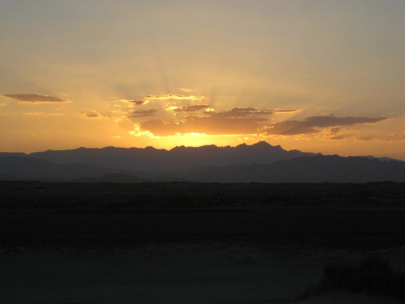
Sundown behind the Sierra San Pedro Mártir, Baja's highest mountains, one peak (El Diablo) is over 10,000 feet. View from about Km. 23.

Sunrise on the Sea of Cortez, about 30 miles south of San Felipe
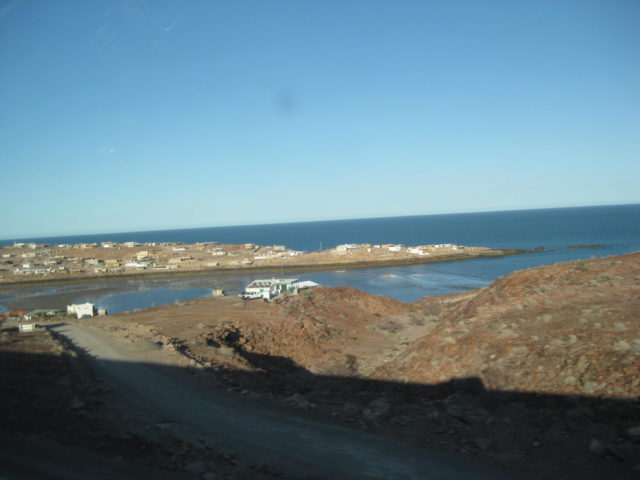
The village of Puertecitos, as seen from the highway, Km. 75-76.

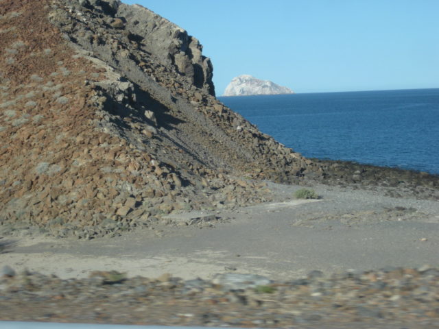
Isla El Huerfanito (The little Orphan Island). It is just off the beach and separated from the other islands by some distance. Km. 103

Isla el Muerto (Dead Man Island). Can you see why it is named that? Km. 110
Isla La Lobera in the distance and the site of Okie’s Landing, a popular fishing campo in the 1960s. Today, simply a spot at Km. 117.
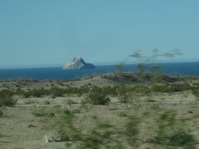
This archipelago is known as Las Encantadas, or The Enchanted Islands. Consisting of volcanic pumice, when parts break off, they float! The beaches up
and down this coast are litterd with pebbles that float. In a c-cktail, your drink could be 'on the rocks' literally!

Isla San Luis, Km. 128

Islas La Lobera & Encantada
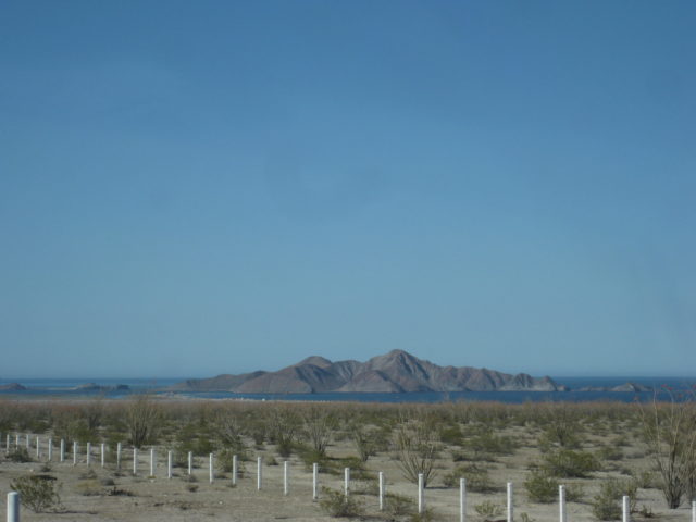
Isla San Luis Gonzaga

South of Gonzaga Bay, the new highway (completed in 2020), passes through a large boulder field in a region named Las Arrastras, after the old gold
ore mills, seen from the bridge just north of Km. 180.

The large arrastra (ore mill) as seen from the highway bridge.

The south end of Highway 5 (Km. 201.5), Laguna Chapala.
OR, you can take the longer route on Hwy. 1 and see dozens of farm towns, and nearly an hour just to get through the city of Ensenada. Do it sometime
to compare the beauty and relaxed drive of Hwy. 5 to the traffic and twisty roads of Hwy. 1. Yes, past El Rosario, 225 miles south of the border, the
desert there is beautiful!
|
|
|
mtgoat666
Select Nomad
Posts: 17284
Registered: 9-16-2006
Location: San Diego
Member Is Offline
Mood: Hot n spicy
|
|
| Quote: Originally posted by David K |
The village of Puertecitos, as seen from the highway, Km. 75-76.
Isla El Huerfanito (The little Orphan Island). It is just off the beach and separated from the other islands by some distance. Km. 103
Isla el Muerto (Dead Man Island). Can you see why it is named that? Km. 110
Isla La Lobera in the distance and the site of Okie’s Landing, a popular fishing campo in the 1960s. Today, simply a spot at Km. 117.
This archipelago is known as Las Encantadas, or The Enchanted Islands. Consisting of volcanic pumice, when parts break off, they float! The beaches up
and down this coast are litterd with pebbles that float. In a c-cktail, your drink could be 'on the rocks' literally!
Isla San Luis, Km. 128
Islas La Lobera & Encantada
Isla San Luis Gonzaga
South of Gonzaga Bay, the new highway (completed in 2020), passes through a large boulder field in a region named Las Arrastras, after the old gold
ore mills, seen from the bridge just north of Km. 180.
The large arrastra (ore mill) as seen from the highway bridge.
The south end of Highway 5 (Km. 201.5), Laguna Chapala.
OR, you can take the longer route on Hwy. 1 and see dozens of farm towns, and nearly an hour just to get through the city of Ensenada. Do it sometime
to compare the beauty and relaxed drive of Hwy. 5 to the traffic and twisty roads of Hwy. 1. Yes, past El Rosario, 225 miles south of the border, the
desert there is beautiful! |
This pics prove my point! 
Twisty roads means mountains, mountains mean scenery!
The lack of population on 5 is testimony to the barren, bleak nature of the land.
The traffic on 1 reflects thriving population on pacific coast reflects how the area is more desirable and people actually choose to live there.
I agree with one point you seem to make, if curvy roads and a little traffic make you uncomfortable when driving, then you should take the bleak 5
route (and ask your children and your doctor if it is still safe for you to drive). If time is more important that quality of life, then by all means
take the 5 and not the 1.
[Edited on 3-18-2023 by mtgoat666]
Woke!
“...ask not what your country can do for you – ask what you can do for your country.” “My fellow citizens of the world: ask not what America
will do for you, but what together we can do for the freedom of man.”
Prefered gender pronoun: the royal we
|
|
|
David K
Honored Nomad
Posts: 64476
Registered: 8-30-2002
Location: San Diego County
Member Is Offline
Mood: Have Baja Fever
|
|
It's not about time goat, it is about stress. Border crossing and city driving in Mexico has got to be stressful for many or at least newbies.
Now, after that, a long, straight, and mostly level highway is by far more relaxing than the nighmare of Ensenada's traffic or the next dozen + towns
with their local traffic and slow tractors, on the 2-lane highway, full of cars, trucks, and busses to pass or stay trapped behind on the mountain
roads just south of Ensenada and again south of El Rosario.
I am not saying never drive Hwy. 1 to Laguna Chapala, but if it is a Nomad's goal to get south and not tour the north, then get south (and/or north)
easily on Hwy. 5.
Edit: why would you duplicate all my photos if they don't appeal to you. It is possible to quote me and not include the photos. You must like what you
see?
[Edited on 3-18-2023 by David K]
|
|
|
mtgoat666
Select Nomad
Posts: 17284
Registered: 9-16-2006
Location: San Diego
Member Is Offline
Mood: Hot n spicy
|
|
| Quote: Originally posted by David K | why would you duplicate all my photos if they don't appeal to you. It is possible to quote me and not include the photos. You must like what you see?
[Edited on 3-18-2023 by David K] |
You pics capture the bleak wasteland, seemed appropriate to repeat the photos, to emphasize the dreary view that is the windshield on Hwy 5.
Woke!
“...ask not what your country can do for you – ask what you can do for your country.” “My fellow citizens of the world: ask not what America
will do for you, but what together we can do for the freedom of man.”
Prefered gender pronoun: the royal we
|
|
|
mtgoat666
Select Nomad
Posts: 17284
Registered: 9-16-2006
Location: San Diego
Member Is Offline
Mood: Hot n spicy
|
|
| Quote: Originally posted by David K | the nighmare of Ensenada's traffic or the next dozen + towns with their local traffic and slow tractors, on the 2-lane highway, full of cars, trucks,
and busses to pass or stay trapped behind on the mountain roads just south of Ensenada and again south of El Rosario.
|
Nightmare? Lighten up, it is a little traffic. Put on some tunes, the miles slip by,…. What’s your rush? Why does slowing down for a moment
stress you out?
Woke!
“...ask not what your country can do for you – ask what you can do for your country.” “My fellow citizens of the world: ask not what America
will do for you, but what together we can do for the freedom of man.”
Prefered gender pronoun: the royal we
|
|
|
David K
Honored Nomad
Posts: 64476
Registered: 8-30-2002
Location: San Diego County
Member Is Offline
Mood: Have Baja Fever
|
|
Dude, if you like cities, why even go to Mexico? Baja, away from cities and highways, is the ultimate 'escape from civilization'!
Why do you follow me, quote me, then say you don't like what I say or show here?
[Edited on 3-19-2023 by David K]
|
|
|
AKgringo
Elite Nomad
Posts: 5805
Registered: 9-20-2014
Location: Anchorage, AK (no mas!)
Member Is Online
Mood: Retireded
|
|
Lincoln.....?
Four score and seven weeks ago, I set forth upon a dental appointment in La Paz. I sometimes drove at night, and lived to tell about
it!
I had the benefit of a full moon, so I would take a break at sundown when it is really hard to see and be seen by oncoming traffic. It was a good
time for my dog and I to chow down and stretch our legs a bit (hers a lot!).
I would not drive some of the twisty mountain roads or blow through some of the beautiful scenic stretches at night, but on roads like the one south
of Ciudad Constitución, I didn't miss much!
If you are not living on the edge, you are taking up too much space!
"Could do better if he tried!" Report card comments from most of my grade school teachers. Sadly, still true!
|
|
|
mtgoat666
Select Nomad
Posts: 17284
Registered: 9-16-2006
Location: San Diego
Member Is Offline
Mood: Hot n spicy
|
|
Well, Mexico has some great cities…
Mexico has some nice remote/rural areas.
Who says you can’t enjoy both?
I am just going to avoid the politics you tried to interject! 
[Edited on 3-18-2023 by mtgoat666]
Woke!
“...ask not what your country can do for you – ask what you can do for your country.” “My fellow citizens of the world: ask not what America
will do for you, but what together we can do for the freedom of man.”
Prefered gender pronoun: the royal we
|
|
|
Bildo
Newbie
Posts: 12
Registered: 3-16-2023
Member Is Offline
|
|
I think I have the route planned out. Cross the border and head to San Felipe to Loreto to Cabo.
How do you nomads feel about safety these days ?
Bill
|
|
|
| Pages:
1
2 |
|


