| Pages:
1
2
3 |
David K
Honored Nomad

Posts: 64532
Registered: 8-30-2002
Location: San Diego County
Member Is Offline
Mood: Have Baja Fever
|
|
Gee thanks, Harald 
The 1922 Map at VivaBaja/maps has it as plain as day, south of the main road to Cataviña and just east of the road to Puerto Santa Catarina. On the
1922 map, it is listed south of 'Onyx' (El Mármol).
|
|
|
David K
Honored Nomad
Posts: 64532
Registered: 8-30-2002
Location: San Diego County
Member Is Offline
Mood: Have Baja Fever
|
|
Quote: Originally posted by bajaric  | | Quote: Originally posted by David K | Perfect...
I have Homer's report on VivaBaja.com/maps, preserved by Fred Metcalf: https://vivabaja.com/wp-content/uploads/2021/12/History-of-t... along with his map showing the route of the main road to the tip, over the years:
https://vivabaja.com/wp-content/uploads/2021/12/Aschmann-197...
The old (pre-1973) route to La Paz is just west of Mex. #1, north of Punta Prieta. You can see it on satellite images. It wanders to the west from the
pavement south of El Crucero.
The road described by Hale in the 1920s is one I have wanted to see but a not so straightly engineered road is all that there is from Leon Grande
south to Punta Prieta. He may have written the book closer to the 1968 publishing date and the details could have been lost to memory after 40 years?
|
I think "the old (pre-1973) route to La Paz" or what i call "Old Hwy 1" was "the road to nowhere" described by Hale. If it had been the trail to Leon
Grande it would not have terminated abruptly in the desert. I would liken it to highway 5, before it was finished and it just stopped in the desert
north of Gonzaga.
Leon Grande, the spring and mining camp, was well-known enough to have been shown on maps. Beal's 1923 Geology map on vivabaja.com, probably the most
accurate, shows Leon Grande as about ten miles north of 29 degrees latitude and 27 miles due west of the coast at Bahia Blanca. This would put Leon
Grande about here: 29.043 -114.199, which makes sense, although that is only about 5 miles north of 29 latitude it is the right location in relation
to Aqua Leon. Or Leon Grande is somewhere north of there.
You can see an old trail that goes past that point and south until it hits Hwy 1. That was the probably the spot where Hale stumbled upon the end of
the road to nowhere, before the road was completed all the way to Chapala several years later and bypassed the trail that went past Leon Grande and
Agua Leon.
[Edited on 4-12-2023 by bajaric] |
Good morning Ric, here on Nomad, finding Leon Grande was a big project a while back... We had a 'consensus'  that we found it, at the very end of the road that goes north-northwest from Punta Prieta, the same distance that
Hale mentioned. Look here (basically more west from your point, west of Parador Punta Prieta): 29.0284, -114.2547 Of course just because there is a
consensus, doesn't make it a fact! that we found it, at the very end of the road that goes north-northwest from Punta Prieta, the same distance that
Hale mentioned. Look here (basically more west from your point, west of Parador Punta Prieta): 29.0284, -114.2547 Of course just because there is a
consensus, doesn't make it a fact! 
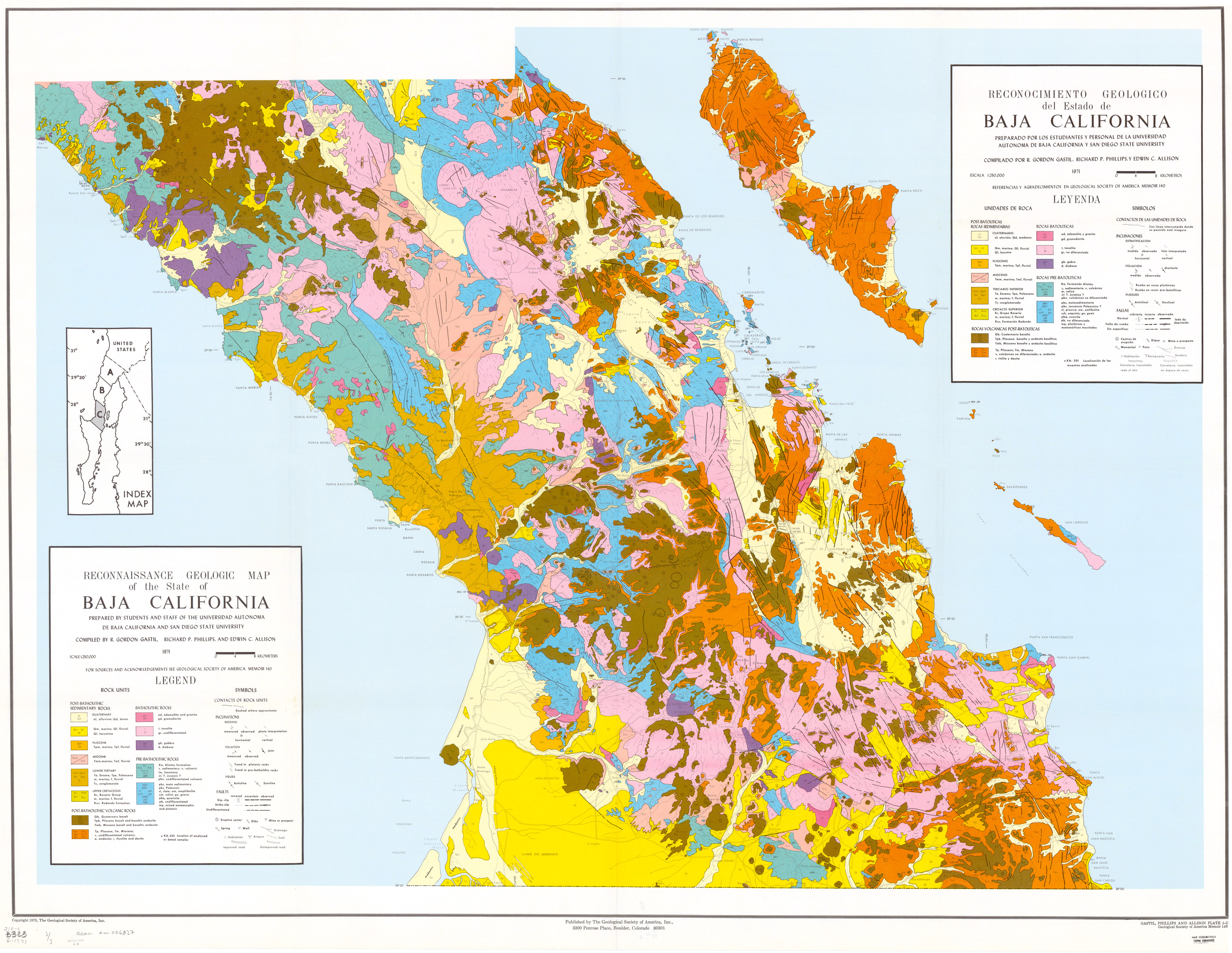
The very detailed 1971 Geology map shows it well, too. 1971 Geology Map, south section
I do hope one of us actually drives the 8-9 road miles north from Punta Prieta and takes photos! I think the old Baja Amigo prospector 'Gila Oro'
(Max) spent some time there... 20 years+ ago?
|
|
|
bajaric
Senior Nomad
Posts: 608
Registered: 2-2-2015
Member Is Offline
|
|
Hello DK, I do remember that discussion. Your GPS location above is a mine called La Venada, (the deer) at the end of a dead-end road up in the
mountains. It is not on a north-south trail as the terrain to the north is impassable.
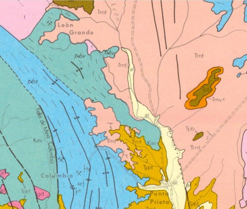
Take a closer look at the 1971 geological map. It shows a mine symbol for Leon Grande 3.3 miles north of La Venada, on a little hill about 1.2 miles
southwest of Mesas el Leoncito. If there is a spring there that is probably Leon Grande, the historical water hole on the old western trail.
I initially thought that was just a mine called Leon Grande but it just dawned on me that whoever drew that map may have put a mine symbol where there
was actually a mining camp or mill, a common practice among cartographers.
[Edited on 4-12-2023 by bajaric]
|
|
|
David K
Honored Nomad
Posts: 64532
Registered: 8-30-2002
Location: San Diego County
Member Is Offline
Mood: Have Baja Fever
|
|
I am not seeing any La Venada on the 1971 map. What are you looking at?
If the 1971 map is wrong, and what they have as Leon Grande is La Venada, then are you saying Leon Grande is 3.3 miles beyond? I just did an arc sweep
3.3 miles out... and saw nothing on Google Earth.
I am very interested in seeing what you are describing!
The GPS waypoint I gave for Leon Grande is 9 miles (direct, as the crow flies) from Punta Prieta, old town, on a heading of 321.45° (north west
north). It also is 6.3 miles from the old Parador Punta Prieta, where gas is now sold out of cans, on a heading of 259.4° (westward).
Here is a close up of the 1971 map (published in 1973) with Punta Prieta at the bottom and Leon Grande near the top. The map is showing about a 10 x
12 mile-wide area.
[Edited on 4-12-2023 by David K]
|
|
|
4x4abc
Ultra Nomad
Posts: 4199
Registered: 4-24-2009
Location: La Paz, BCS
Member Is Offline
Mood: happy - always
|
|
| Quote: Originally posted by David K |
The 1922 Map at VivaBaja/maps has it as plain as day, south of the main road to Cataviña and just east of the road to Puerto Santa Catarina. On the
1922 map, it is listed south of 'Onyx' (El Mármol). |
got it
matches today's sat images
but it does not match the image in the Engerrand paper (Mountains in Engerrand image are much higher than at the La Sierrita map location)
Harald Pietschmann
|
|
|
4x4abc
Ultra Nomad
Posts: 4199
Registered: 4-24-2009
Location: La Paz, BCS
Member Is Offline
Mood: happy - always
|
|
La Venada:
https://www.gob.mx/profepa/prensa/clausura-profepa-proyecto-...
Harald Pietschmann
|
|
|
4x4abc
Ultra Nomad
Posts: 4199
Registered: 4-24-2009
Location: La Paz, BCS
Member Is Offline
Mood: happy - always
|
|
Mesas el Leoncito (INEGI): 29° 5.915'N, 114° 14.041'W and 29° 10.007'N, 114° 13.271'W
[Edited on 4-12-2023 by 4x4abc]
Harald Pietschmann
|
|
|
bajaric
Senior Nomad
Posts: 608
Registered: 2-2-2015
Member Is Offline
|
|
| Quote: Originally posted by David K | I am not seeing any La Venada on the 1971 map. What are you looking at?
If the 1971 map is wrong, and what they have as Leon Grande is La Venada, then are you saying Leon Grande is 3.3 miles beyond? I just did an arc sweep
3.3 miles out... and saw nothing on Google Earth.
I am very interested in seeing what you are describing!
The GPS waypoint I gave for Leon Grande is 9 miles (direct, as the crow flies) from Punta Prieta, old town, on a heading of 321.45° (north west
north). It also is 6.3 miles from the old Parador Punta Prieta, where gas is now sold out of cans, on a heading of 259.4° (westward).
Here is a close up of the 1971 map (published in 1973) with Punta Prieta at the bottom and Leon Grande near the top. The map is showing about a 10 x
12 mile-wide area.
[Edited on 4-12-2023 by David K] |
The mine symbol labeled Leon Grande on the 1971 geological map is in the upper left hand corner. Zoomed in a bit shows 3 possible sites for Leon
Grande; 1971 map, Haralds proposed location, and La Venada. It is unclear if the site shown on the 1971 map is Leon Grande, the spring, or a mine
with the same name.


[Edited on 4-13-2023 by bajaric]
|
|
|
4x4abc
Ultra Nomad
Posts: 4199
Registered: 4-24-2009
Location: La Paz, BCS
Member Is Offline
Mood: happy - always
|
|
| Quote: Originally posted by bajaric |
The 1971 map shows Leon Grande about 1 mile south of Mesa el Leoncito, as can be seen when comparing it to Google Earth. I could give you the GPS
coordinates, but it is a secret. You have to work for it lol.
[Edited on 4-12-2023 by bajaric] |
secret?
I am out
Harald Pietschmann
|
|
|
bajaric
Senior Nomad
Posts: 608
Registered: 2-2-2015
Member Is Offline
|
|
Interesting article that they shut down La Venada. Thats the place DK thought was Leon Grande.
|
|
|
Lance S.
Nomad
Posts: 163
Registered: 2-16-2021
Member Is Offline
|
|
The La Venada mining exploration project was at the former Leon Grande mine?
|
|
|
4x4abc
Ultra Nomad
Posts: 4199
Registered: 4-24-2009
Location: La Paz, BCS
Member Is Offline
Mood: happy - always
|
|
here is "secret" Mina Leon Grande: 29° 3.637'N, 114° 17.185'W
and the secret road leading there:
Attachment: 4x4 trail mining faint Leon Grande.kmz (6kB)
This file has been downloaded 59 times
Attachment: 4x4 rural mining faint.kmz (2kB)
This file has been downloaded 64 times
Attachment: 4x4 rural mining.kmz (1kB)
This file has been downloaded 63 times
Attachment: 4x4 rural mining1.kmz (2kB)
This file has been downloaded 77 times
Attachment: 4x4 rural mining2.kmz (1kB)
This file has been downloaded 61 times
Attachment: 4x4 rural mining4.kmz (6kB)
This file has been downloaded 73 times
Harald Pietschmann
|
|
|
4x4abc
Ultra Nomad
Posts: 4199
Registered: 4-24-2009
Location: La Paz, BCS
Member Is Offline
Mood: happy - always
|
|
here is a Google Earth overlay with the geo map
download the Leon Grande Overlay kmz
and download the map image below
open kmz in GE
"ctrl - I" ("cmd - I" on Mac) the overlay kmz
then link to the downloaded jpg
Attachment: Leon Grande Overlay.kmz (263kB)
This file has been downloaded 59 times


Harald Pietschmann
|
|
|
4x4abc
Ultra Nomad
Posts: 4199
Registered: 4-24-2009
Location: La Paz, BCS
Member Is Offline
Mood: happy - always
|
|
reference points:
Agua Leon: 29° 9.934'N, 114° 13.762'W
La Vachata: 28° 50.219'N, 114° 7.303'W
Harald Pietschmann
|
|
|
Lance S.
Nomad
Posts: 163
Registered: 2-16-2021
Member Is Offline
|
|
I think the Punta Prieta on the geology map Harald posted is cerro Punta Prieta rather than the town. It is in the correct location for the cerro,
inland from Playa maria.
[Edited on 4-12-2023 by Lance S.]
|
|
|
4x4abc
Ultra Nomad
Posts: 4199
Registered: 4-24-2009
Location: La Paz, BCS
Member Is Offline
Mood: happy - always
|
|
Google just added another major image blocking section
somebody has an interest that the public will not see details in that area
Harald Pietschmann
|
|
|
Lance S.
Nomad
Posts: 163
Registered: 2-16-2021
Member Is Offline
|
|
That's crazy, is it blocked for all dates?
|
|
|
4x4abc
Ultra Nomad
Posts: 4199
Registered: 4-24-2009
Location: La Paz, BCS
Member Is Offline
Mood: happy - always
|
|
the entire date range
I am lucky - I recorded some tracks before the blockage
Harald Pietschmann
|
|
|
4x4abc
Ultra Nomad
Posts: 4199
Registered: 4-24-2009
Location: La Paz, BCS
Member Is Offline
Mood: happy - always
|
|
the current blocks I came across the last few months
Harald Pietschmann
|
|
|
David K
Honored Nomad
Posts: 64532
Registered: 8-30-2002
Location: San Diego County
Member Is Offline
Mood: Have Baja Fever
|
|
Harald, Geoffff photographed the spring of Agua Leon in his newest trip report. It is a few hundred feet north of your point, next to where the road
ends in these trees: 29.1701, -114.2294
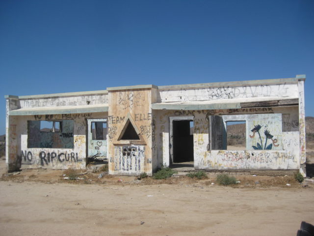
Spelled on all modern maps as La Bachata, along the highway at Km. 24.5 is an abandoned home with a triangle window: 28.8365, -114.1252 (this is a few
hundred feet west of your point, across the highway).
|
|
|
| Pages:
1
2
3 |


