| Pages:
1
2
3
4
..
7 |
4x4abc
Ultra Nomad

Posts: 4171
Registered: 4-24-2009
Location: La Paz, BCS
Member Is Offline
Mood: happy - always
|
|
OK - next
Harald Pietschmann
|
|
|
Lance S.
Nomad
Posts: 152
Registered: 2-16-2021
Member Is Online
|
|
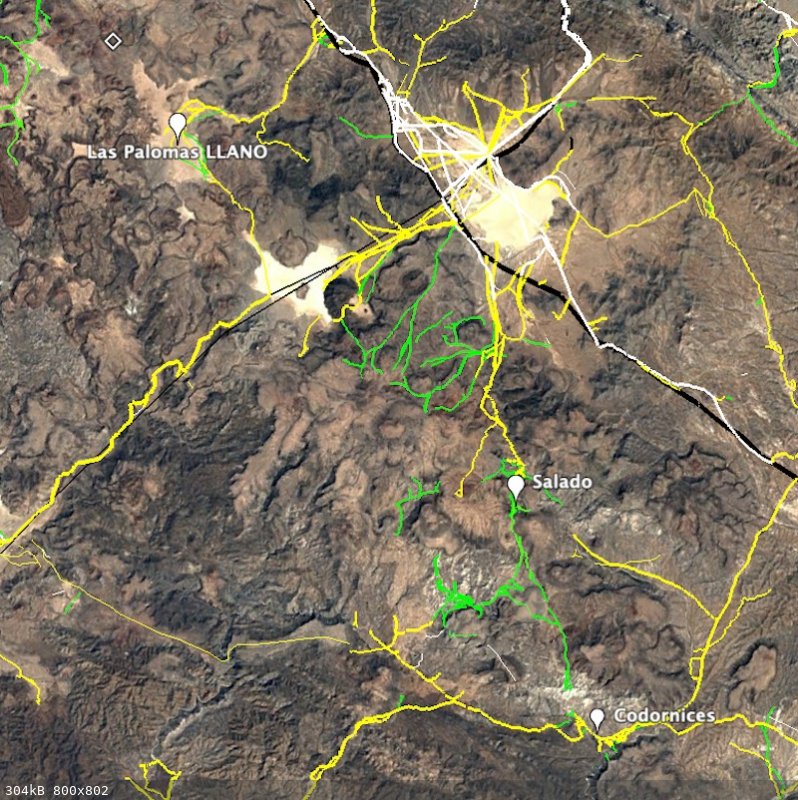
You actually have the route between Codornices and Salado marked .
[Edited on 4-17-2023 by Lance S.]
|
|
|
Lance S.
Nomad
Posts: 152
Registered: 2-16-2021
Member Is Online
|
|

Salado
[Edited on 4-16-2023 by Lance S.]
|
|
|
4x4abc
Ultra Nomad
Posts: 4171
Registered: 4-24-2009
Location: La Paz, BCS
Member Is Offline
Mood: happy - always
|
|
you are right - I found animal trails that support that idea
but the spring is not on the travel route
Harald Pietschmann
|
|
|
Lance S.
Nomad
Posts: 152
Registered: 2-16-2021
Member Is Online
|
|
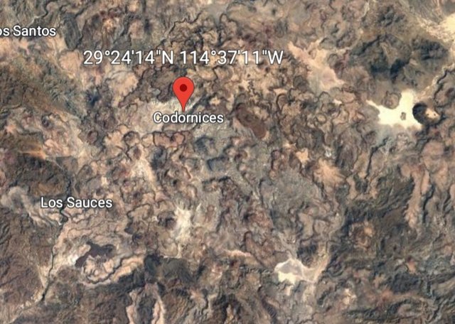
Las Palomas (now called Codornices)
 upload image to link upload image to link
You can make out the route from the water to there. Easiest if you work back from Palomas.
[Edited on 4-16-2023 by Lance S.]
|
|
|
4x4abc
Ultra Nomad
Posts: 4171
Registered: 4-24-2009
Location: La Paz, BCS
Member Is Offline
Mood: happy - always
|
|
I can only fill in what I see on the sat images
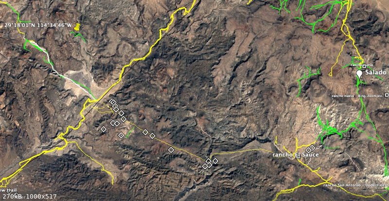
I have some promising traces between Rancho El Sauce and Laguna El Caporal
but nothing from Salado to El Caporal - all trails there are radiating out from Laguna Chapala
Harald Pietschmann
|
|
|
4x4abc
Ultra Nomad
Posts: 4171
Registered: 4-24-2009
Location: La Paz, BCS
Member Is Offline
Mood: happy - always
|
|
Quote: Originally posted by Lance S.  | | You know that small lake bed between Chapala and the coast? That is Salado. 29°16'05"N 114°34'34"W .Very salty water when it fills up, you can
probably see in past Google earth images. There is a waterhole nearby. |
Laguna El Caporal
Harald Pietschmann
|
|
|
Lance S.
Nomad
Posts: 152
Registered: 2-16-2021
Member Is Online
|
|
Thank you! Was wondering if it even had a modern name.
|
|
|
4x4abc
Ultra Nomad
Posts: 4171
Registered: 4-24-2009
Location: La Paz, BCS
Member Is Offline
Mood: happy - always
|
|
so we have 2 Codornices now?
that'll be confusing!
Harald Pietschmann
|
|
|
Lance S.
Nomad
Posts: 152
Registered: 2-16-2021
Member Is Online
|
|
Yup! That was already part of the confusion I think.
|
|
|
David K
Honored Nomad
Posts: 64493
Registered: 8-30-2002
Location: San Diego County
Member Is Offline
Mood: Have Baja Fever
|
|
Guys, I have been standing back hoping to see some perfecting of the map Harald put out... I hope you don't give up!
We are certain of where Codornices is and were Agua Leon is.
Also, I am exchanging data with the Arce clan, one branch is the family owns that ranch and it has been there over 100 years.
Salomé Arce Villavicencio (daughter of Marcelino Arce & Cleofas Villavicencio), was born there. She was Eliodoro's (the prospector we have been
talking about) aunt. Salomé married Jesús Zúñiga. Her grandchildren are adults on the Internet today.
The land remains in the hands of that family today.
Los Codornices and San Antonio are the same place, even the family uses both names (I will try and find out that story). 'geoffff' was there as well.
Just an adobe ruin by a giant eucalyptus tree: 29.1959, -114.3170
[Edited on 4-17-2023 by David K]
|
|
|
PaulW
Ultra Nomad
Posts: 3009
Registered: 5-21-2013
Member Is Offline
|
|
Looking for Codornices on the San Antonio route:
Yes “Los Codornices and San Antonio are the same place.”
According to the Almanac they are in the same place. The new Atlas shows just San Antonio.
The Almanac shows a Codornices further west on the San Antonio route and the new Atlas calls that place Los Palomas.
Look at 29 1.617, -114 32.137 just see a blur with a bunch of roads, but a couple of building a bit north.
The largest ranch with unknown name along that route is at 20 8.767, -114 20.619
Google Earth shows Codornices as an area at 29 8.767, -114 21.155. It is along a major wash.
|
|
|
4x4abc
Ultra Nomad
Posts: 4171
Registered: 4-24-2009
Location: La Paz, BCS
Member Is Offline
Mood: happy - always
|
|
| Quote: Originally posted by PaulW | Looking for Codornices on the San Antonio route:
Yes “Los Codornices and San Antonio are the same place.”
According to the Almanac they are in the same place. The new Atlas shows just San Antonio.
The Almanac shows a Codornices further west on the San Antonio route and the new Atlas calls that place Los Palomas.
Look at 29 1.617, -114 32.137 just see a blur with a bunch of roads, but a couple of building a bit north.
The largest ranch with unknown name along that route is at 20 8.767, -114 20.619
Google Earth shows Codornices as an area at 29 8.767, -114 21.155. It is along a major wash.
|
lotsa Codornices - lotsa Las Palomas in the area
H11D49
29 8.767, -114 21.155 is Arroyo Cordonices
Harald Pietschmann
|
|
|
David K
Honored Nomad
Posts: 64493
Registered: 8-30-2002
Location: San Diego County
Member Is Offline
Mood: Have Baja Fever
|
|
Palomas=Doves
Codornices=Quail
Anyone can put a name on the map but if you talk to the people who own or live at these places, you may learn more.
My connections with the Arce clan keeps growing and I am editing the Eliodoro Arce family tree almost daily. They are very open to sharing the family
history and that gives us history and map fans a great insight to these places. I will ask them about these places... soon. Still working on
translating their messages and applying the data into the family tree. It is all under construction so if you don't mind a rough look, go to the
bottom of the Eliodoro page. www.vivabaja.com/eliodoro
Here is what I have (so far) on the family who owns Rancho (Los) Codornices/ San Antonio:
Salomé Arce Villavicencio [Los Codornices/ San Antonio]; Primitivo's sister hermana/ Eliodoro's aunt tía) & Jesús
Zúñiga >> Chacha Margarita, Celia Nelo, José María, Teodora ('Toña') Zúñiga Arce & Pilar Cota >>
t-1) María Cota Zúñiga & Manuel Ruelas >> Manuel Ruelas Cota. t-2) Teodoro Estrada Zúñiga.
|
|
|
4x4abc
Ultra Nomad
Posts: 4171
Registered: 4-24-2009
Location: La Paz, BCS
Member Is Offline
Mood: happy - always
|
|
whenever a new topic comes up I use the opportunity to re-visit the area
do some updates if needed (lotsa new roads over the last few years!)
connected to this topic I found a new airstrip in the middle of nowhere
some new roads around it
maybe mining
29° 10.322'N, 114° 30.011'W
Harald Pietschmann
|
|
|
David K
Honored Nomad
Posts: 64493
Registered: 8-30-2002
Location: San Diego County
Member Is Offline
Mood: Have Baja Fever
|
|
That's just up the arroyo from La Miseria (now abandoned and roofless) where you can still see the two hot tubs.
|
|
|
4x4abc
Ultra Nomad
Posts: 4171
Registered: 4-24-2009
Location: La Paz, BCS
Member Is Offline
Mood: happy - always
|
|
2 new airstrips at Laguna La Guija 29° 24.519'N, 114° 29.460'W
29° 23.666'N, 114° 29.418'W
Harald Pietschmann
|
|
|
David K
Honored Nomad
Posts: 64493
Registered: 8-30-2002
Location: San Diego County
Member Is Offline
Mood: Have Baja Fever
|
|
That first one has already been ditched by the army.
Are we not getting a bit off topic with gps waypoints for drug-runner runways? 
Seriously Harald, a thread just on your drug runway discoveries would be huge!
|
|
|
Lance S.
Nomad
Posts: 152
Registered: 2-16-2021
Member Is Online
|
|
The next stop on Goldbaum after Las Palomas is San Jose. That is another San Jose de Las Palomas. Apparently the newer location of the same ranch.
The next section of the map, San Jose to San Julio, is now followed by a road so I guess the question is which locations on the road have water near
the surface and which have deeper drilled wells.
[Edited on 4-18-2023 by Lance S.]
|
|
|
David K
Honored Nomad
Posts: 64493
Registered: 8-30-2002
Location: San Diego County
Member Is Offline
Mood: Have Baja Fever
|
|
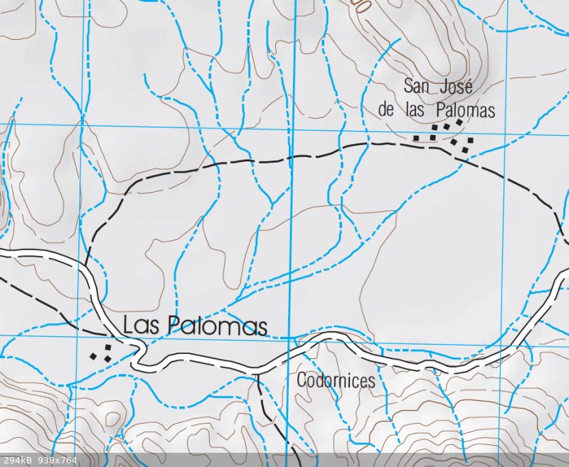
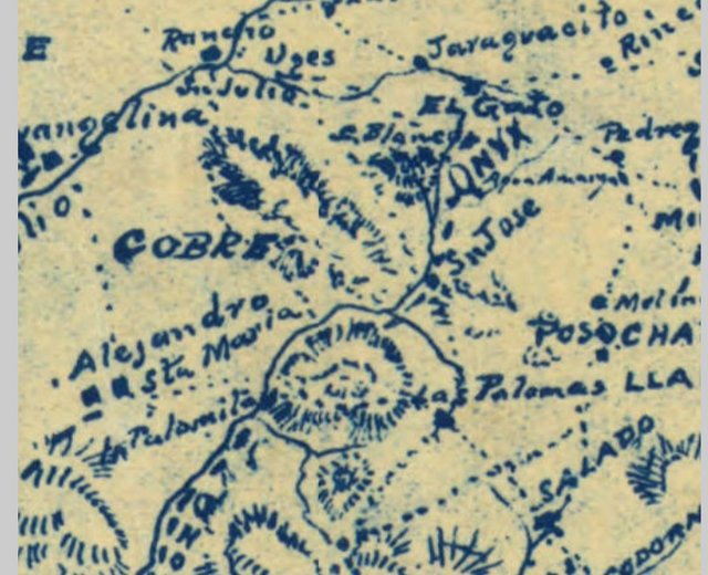
Fun with Maps!
Notice the names on Goldbaum's map (top to bottom): C Blanco, Onyx (and to the right, part of Pedregoso), San Jose, Las Palomas.
On the Gulick map, below: Cerro Blanco (Onyx), El Pedregoso, San José, Las Palomas (at the bottom).
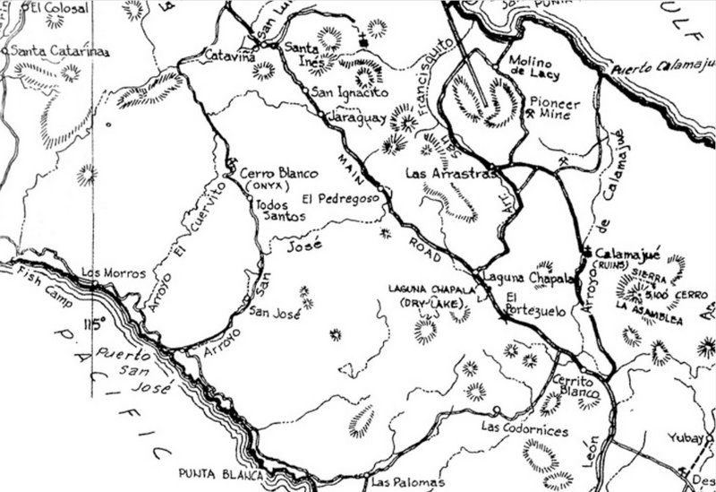
Above is the 1962 Howard Gulick/ Lower California Guidebook Map, which was researched from 1958 to 1961... and as Harald stated, they are the first
accurate road maps of Baja. His previous two guidebook editions (1956 & 1958) did not include the roads to the Pacific (Seven Sisters) Coast.
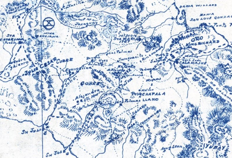
At roughly the same area as the Gulick map above:
|
|
|
| Pages:
1
2
3
4
..
7 |


