| Pages:
1
..
4
5
6
7
8
..
10 |
bajaric
Senior Nomad

Posts: 610
Registered: 2-2-2015
Member Is Offline
|
|
I think the trail from San Ignacio to San Andreas came into general use during the California Gold Rush. It involved crossing the Vizcaino desert
between San Angel and Ojo de Liebre, a distance of 70 miles between water holes. The advantage of this route was that it bypassed a difficult section
of El Camino Real between San Ignacio and San Borja, and was probably made possible by better methods of carrying water than were available to the
missionaries.
From San Andreas north to San Fernando was probably also quite difficult. I think some of the 49's decided to cross from Rosarito over to San Borja
and continue north along El Camino Real rather than brave this trail across the Sierra Columbia. In the late 1800's - 1910's the San Andreas / San
Fernando trail probably saw some use as a connecting trail between various ranchos and mining camps. The trail must have passed Leon Grande, the
water hole, which is why Leon Grande is shown on all the old maps.
So the question is, where is Leon Grande? Now we have a half dozen guesses as to its location. Lances' location from page 1 of thread is included
along with various other guesses and locations shown on various (inaccurate) old maps. Unfortunately, Gerhard and Gulik, the first accurate map of
Baja, does not show the location for Leon Grande. By the 1950's the trail that went past Leon Grande had long since been abandoned in favor of what
we today call Hwy. 1.
My guess is that Leon Grande, the spring, was somewhere near the point shown as "Harald Leon Grande", or a little east of there. From Leon Grande the
trail went north to Agua Leon, shown at the top of the map.
edit: There is no 1941 AAA map that shows Leon Grande. That was a mistake. Also "Codernices" is a Google Earth error and is not the correct
location.
[Edited on 4-16-2024 by bajaric]
|
|
|
Lance S.
Nomad
Posts: 163
Registered: 2-16-2021
Member Is Offline
|
|
Ric, do you have San Ignacio to San Andres marked out on Google Earth?
|
|
|
David K
Honored Nomad
Posts: 64540
Registered: 8-30-2002
Location: San Diego County
Member Is Offline
Mood: Have Baja Fever
|
|
Great stuff! 
|
|
|
bajaric
Senior Nomad
Posts: 610
Registered: 2-2-2015
Member Is Offline
|
|
Hi Lance, no have not plotted that. Reading the source you posted (in Spanish) it is pretty detailed describing the route: San Ignacio / San Angel
/Ojo de Libre / Toro / Rosarito / San Andres, as best I can determine with my limited Spanish. He noted that Ojo de Libre had been visited by
travelers during the gold rush. From San Andreas north to La Sierrita there is no description of the trail other than it was seldom used because of
the lack of water and difficult terrain.
I'm still working on Leon Grande location. I went back and looked at "Long Road to Mulege" by Hale. He described Leon Grande as 10 kilometers "mas o
menos" south of Agua Leon.
|
|
|
Lance S.
Nomad
Posts: 163
Registered: 2-16-2021
Member Is Offline
|
|
It says the coastal arm between San Andres and La Sierrita is bad and seldom used but that the inland arm passes over " buen torreno".
There are some places missing from the description of the route between San Ignacio and San Andres, I will have to look and try to fill it in
sometime.
[Edited on 4-18-2024 by Lance S.]
|
|
|
lencho
Junior Nomad
Posts: 97
Registered: 1-16-2005
Location: Tan lejos de Dios y tan cerca de EU
Member Is Offline
Mood: Somnoliento
|
|
Almost certainly "...buen terreno...", in case accuracy matters.
[Edited on 4-18-2024 by lencho]
"I can normally tell how intelligent a man is, by how stupid he thinks I
am."
"...they were careful of their demeanor that they not be thought to have opinions on what they heard for like most men skilled at their work they
were scornful of any least suggestion of knowing anything not learned at first hand."
Cormac McCarthy, All the Pretty Horses
"Be kind, be patient, help others." -- Isabel Allende
"My gas stove identifies as electric." Anonymous

|
|
|
David K
Honored Nomad
Posts: 64540
Registered: 8-30-2002
Location: San Diego County
Member Is Offline
Mood: Have Baja Fever
|
|
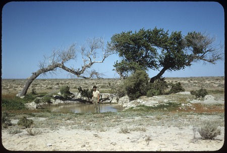
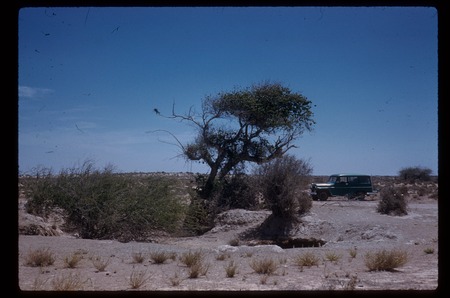
Ojo de Liebre in 1953 by Howard Gulick
In 1961, Howard returned...
|
|
|
4x4abc
Ultra Nomad
Posts: 4199
Registered: 4-24-2009
Location: La Paz, BCS
Member Is Offline
Mood: happy - always
|
|
putting a pin into Google Earth for a possible historic location is exciting
lotsa thinking, reading, comparing, speculating before you feel safe to do so
I have been focussing on something else the last 10 years
finding and recording possible trails between those locations
if a trail has been used by animals before humans used it and animals continued to use it when the humans found easier paths then it is kinda easy
but when humans blazed fresh trails they are very difficult to find after 100 years of non use.
so far I have only faint hints between Leon Grande and Codornices
it looks like the route through Punta Prieta and Agua Leon was preferred
lotsa trails
[Edited on 4-20-2024 by 4x4abc]
Harald Pietschmann
|
|
|
Lance S.
Nomad
Posts: 163
Registered: 2-16-2021
Member Is Offline
|
|
Absolutely. Here is my thinking on this.
I only wanted to include places where water would have been available before drilling deep wells became feasible (apart from the newer San Jose since
it is next to the original). Notice I didn't include Punta Prieta. Seems like a long distance to go between San Andres and Agua Leon without water
but maybe it still would have been preferred due to the terrain.
There could have been a branch of the inland arm of the Sierrita route that went Agua Leon - Pozo Chapala - El Gato - Jaraguacito - Las Palmas - San
Julio - Las Casitas(?) - Catarina - La Sierrita. That would be consistent with the "main trail" North described a little before reaching Rinconada.
I would love to see the trails you have found.
[Edited on 4-21-2024 by Lance S.]
[Edited on 4-21-2024 by Lance S.]
|
|
|
mtgoat666
Select Nomad
Posts: 17401
Registered: 9-16-2006
Location: San Diego
Member Is Offline
Mood: Hot n spicy
|
|
You guys are shooting in the dark relying on google earth and old maps by foreign passers by.
Go interview the locals. They know the history, the stories of the old places.
The ranchers know where the old ruins are that are not visible on GE nor traveled by tourists on motorcycles.
The ranchers know where the former springs are that are now dry due to wells lowering the water table.
[Edited on 4-21-2024 by mtgoat666]
Woke!
“...ask not what your country can do for you – ask what you can do for your country.” “My fellow citizens of the world: ask not what America
will do for you, but what together we can do for the freedom of man.”
Prefered gender pronoun: the royal we
|
|
|
Lance S.
Nomad
Posts: 163
Registered: 2-16-2021
Member Is Offline
|
|
Something not discussed as much is the availability of pasture, especially in a desert environment. Available pasture would be used up on frequently
traveled routes like the ECR, perhaps one incentive to use the La Sierrita route at times.
There is a hybrid ECR - La Sierrita route described in the entry for Yubay in Itinererios y Deroteros.
[Edited on 4-21-2024 by Lance S.]
|
|
|
4x4abc
Ultra Nomad
Posts: 4199
Registered: 4-24-2009
Location: La Paz, BCS
Member Is Offline
Mood: happy - always
|
|
Quote: Originally posted by mtgoat666  | You guys are shooting in the dark relying on google earth and old maps by foreign passers by.
Go interview the locals. They know the history, the stories of the old places.
The ranchers know where the old ruins are that are not visible on GE nor traveled by tourists on motorcycles.
The ranchers know where the former springs are that are now dry due to wells lowering the water table.
[Edited on 4-21-2024 by mtgoat666] |
there are no ranchos in the area where you could ask anyone
besides - I found the locals the most unreliable source for infomation when it comes to historical stuff
they know the water sources and their trails
but they could not tell you with certainty whether these trails are ECR or late 1800's mining trails.
locals are very eager to please you - they will tell you anything you want to hear about ECR
of course there are exceptions - there are some very knowledgeable locals in Baja
Edie Littlefield was lucky - she found all the good ones as guides.
in areas where there are no locals Google Earth is a superb tool to locate almost any trail
especially with the recent new, super detailed images.
Harald Pietschmann
|
|
|
David K
Honored Nomad
Posts: 64540
Registered: 8-30-2002
Location: San Diego County
Member Is Offline
Mood: Have Baja Fever
|
|
| Quote: Originally posted by 4x4abc | | Quote: Originally posted by mtgoat666 | You guys are shooting in the dark relying on google earth and old maps by foreign passers by.
Go interview the locals. They know the history, the stories of the old places.
The ranchers know where the old ruins are that are not visible on GE nor traveled by tourists on motorcycles.
The ranchers know where the former springs are that are now dry due to wells lowering the water table.
[Edited on 4-21-2024 by mtgoat666] |
there are no ranchos in the area where you could ask anyone
besides - I found the locals the most unreliable source for infomation when it comes to historical stuff
they know the water sources and their trails
but they could not tell you with certainty whether these trails are ECR or late 1800's mining trails.
locals are very eager to please you - they will tell you anything you want to hear about ECR
of course there are exceptions - there are some very knowledgeable locals in Baja
Edie Littlefield was lucky - she found all the good ones as guides.
in areas where there are no locals Google Earth is a superb tool to locate almost any trail
especially with the recent new, super detailed images. |
Spot on... local ranchers do know their land very well, but not always the true history. They came to Baja for work, to farm, to ranch. They do not
have need for accurate history of the Jesuits or other missionaries, but only to repeat stories told to them. Other than a some miners, south of La
Paz, most people from Mexico didn't come to the peninsula until the 1800s. Just the padres, craftsmen, and Spanish soldiers.
|
|
|
bajaric
Senior Nomad
Posts: 610
Registered: 2-2-2015
Member Is Offline
|
|
There is not much grass in that area...
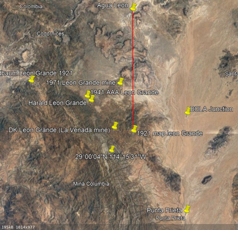
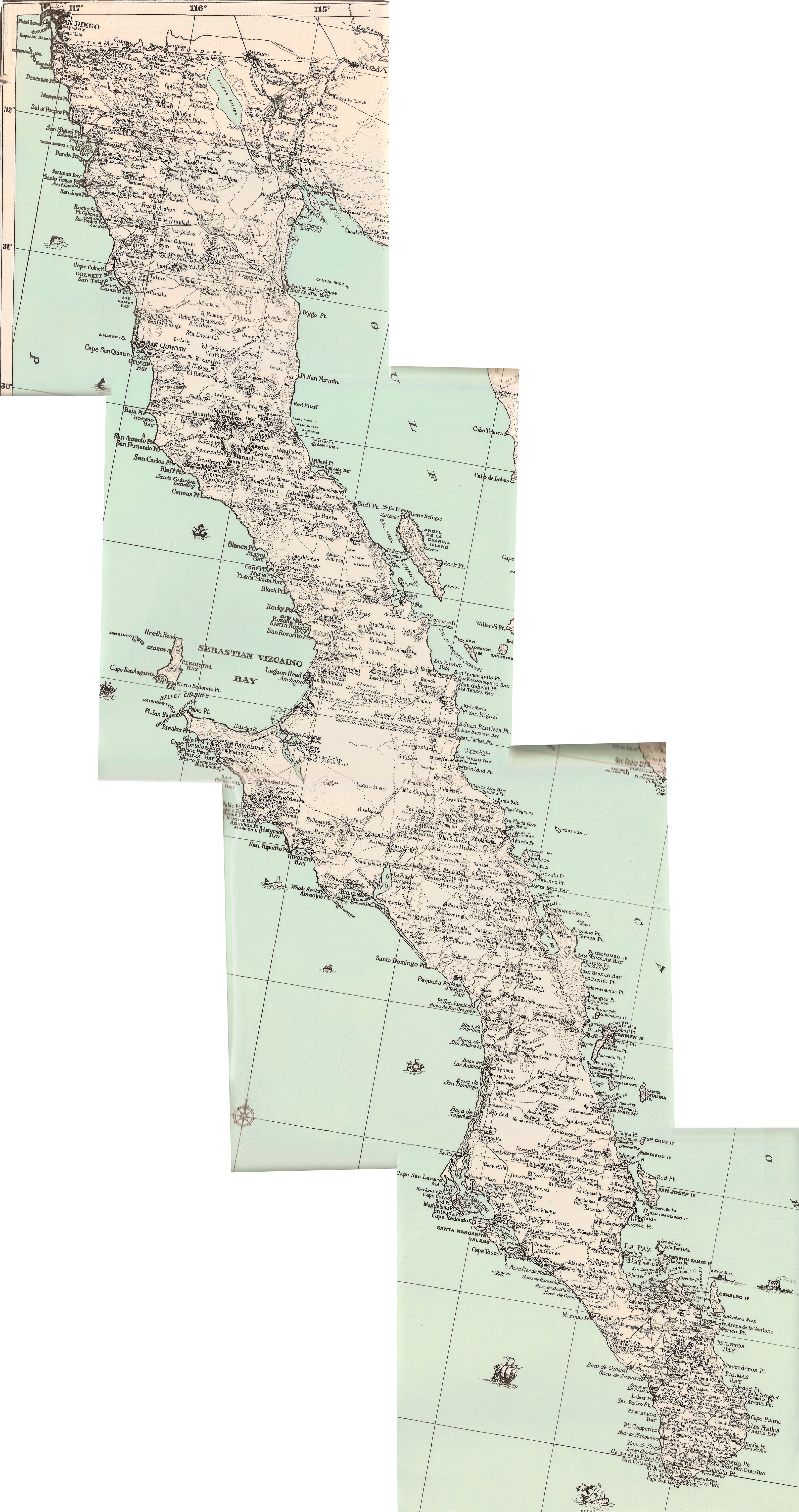
Anyway, back to Leon Grande, the water hole. I looked at some of the old maps that show Leon Grande. Goldbaum's map is typical:

The scale of this map is not accurate. However, it clearly shows Leon Grande as a bit north of latitude 29 degrees but south of the upper part of a
big arroyo that flows past Punta Prieta. To the north this arroyo forks into two main drainages on either side of some hills. It is apparent that
these hills are called Mesas el Leoncito. The mesas are a prominent feature that can be seen on Google Earth. Leon Grande is shown as south of the
upper part of the arroyo that flows along the south side of the mesas.
More information is in the book "Long walk to Mulege" by Hale. On their walk south from Chapala they came upon a road that went towards the gulf.
Following this road they came to an abandoned ranch with a windmill. This was probably El Crucero. From that location they walked southwest, passing
Agua Leon. Walking south from the general area of Agua Leon they followed a shallow arroyo south. When the arroyo turned to the east they continued
south and arrived at Leon Grande, a spring where water came from the side of a cliff.
The next day they continued south, following a burro trail, until they arrived at a graded "road to nowhere" that terminated in the middle of the
desert. This road went to Punta Prieta.
This walk from Leon Grande to Punta Prieta gives an approximate distance from Punta Prieta to Leon Grande, as it was about as far as Hale and his
companion could walk in one day. And those boys could walk! "On our second day out of Ensenada we arrived at Santo Tomas". That is about 24 miles
in two days of walking, or 12 miles a day.
So will all of this information put together I looked at Google Earth to try and find the place.
This is what I came up with. The yellow lines show a faint trail southwest from Agua Leon that passes to the west of Mesas el Leoncitio. The trail
arrives at a shallow arroyo that flows south and then turns east. A couple of miles south of the point where the arroyo turns east another trail
coming in from the west terminates at the coordinates on the map. 29 3'40.34"N -114 17'11.69"W I think this is Leon Grande.
From there the trail goes west, then south towards Punta Prieta until it arrives at Highway 1. This is probably where Hale encountered the end of the
"road to nowhere"; the initial construction of a graded road that eventually went north from Punta Prieta to El Crucero. The road was completed by
about 1925 and the trail past Leon Grande was abandoned.
The point where I think the trail south from Leon Grande ran into the "road to nowhere" is shown by the end of the yellow line south of the pin marked
29 degrees latitude. This is at Hwy 1 (not shown) which is what the road to nowhere eventually became.
The coordinates for Leon Grande came from Harald, who spotted a water source at that location. Unfortunately, on Google Earth not much can be seen
there. No water, no buildings, just what looks like it could be a water hole in an arroyo and maybe some cleared areas. Perhaps the spring dried up.
So, in the end, the location of Leon Grande, the spring, remains a bit of a mystery. I am pretty confident, however, that based on all of the
available information it was probably at or near the location shown by the coordinates on the map: 29 3'40.34"N -114 17'11.69"W
Two other locations shown on the map are Mina Leon Grande and Mina La Venada. La Venada is a modern mine with a modern road to it. Unless Leon
Grande, the water hole, happened to be at the exact same spot as a gold mine, it is unlikely that this is Leon Grande. Mina Leon Grande is shown on a
geological map from 1971 but appears to be a mine, not a water hole. No trails can be seen going to Mina Leon Grande, indicating that it was not a
spring that was on a well-known trail.
For scale, the distance between the BOLA junction and Punta Prieta is 6.8 miles.

|
|
|
David K
Honored Nomad
Posts: 64540
Registered: 8-30-2002
Location: San Diego County
Member Is Offline
Mood: Have Baja Fever
|
|
Great work!
I recall Leon Grande as being mainly a mine site and not a waterhole (which was Agua Leon, that our own 'geoffff' visited on his last Baja trip).
Goldman shows Mina Leon Grande and Oro nearby. The Long Walk book is great fun to read, indeed.
The 1930 Edward Knight map has all these places... but still suffers with some odd inaccuracies: https://octopup.org/img/media/maps/baja/1930--Baja--Lower-Ca...
Hopefully, 4x4abc (Harald) and others will chime in... and at some point, I will open my files on this mystery, again! I have been working on the 1684
Atondo-Kino route and just finished the latest version of details and maps.
Looking at your waypoint in the satellite layer, I don't see any indication of a mine or road.
[Edited on 4-24-2024 by David K]
|
|
|
Lance S.
Nomad
Posts: 163
Registered: 2-16-2021
Member Is Offline
|
|
This is still my guess for the Leon Grande mine 29°01'34"N 114°15'10"W.
The coordinates I gave on the route were for the water source for the mine. Haralds coordinates for Manantial Leon Grande are another good candidate
for the water.
|
|
|
David K
Honored Nomad
Posts: 64540
Registered: 8-30-2002
Location: San Diego County
Member Is Offline
Mood: Have Baja Fever
|
|
Is the La Venada Mine my original guess for Leon Grande? It appears so.. at the northern end of the road from Punta Prieta... the road Hale &
company walked on in the 1920s.
Maybe the two were mine names are confused since Leon Grande was a big enough deal to appear on so many maps and books and La Venada not at all?
There really should be a debris field at Leon Grande or tailings. Don't you think so?
|
|
|
bajaric
Senior Nomad
Posts: 610
Registered: 2-2-2015
Member Is Offline
|
|
What I have been searching for is the water source described by Hale that was called Leon Grande. He described it as 15 kilometers "mas o menos"
south of Agua Leon. (I think I made a mistake in another thread and said 10 kilometers). That puts it right at the place that I think is Leon Grande
shown by the coordinates on my Google Earth map above.
The road from La Venada to Punta Prieta does not match Hale's description of the trail from Leon Grande to Punta Prieta. However, the trail from the
place that I think is Leon Grande matches his description almost exactly. You have really squint but there is a clear trail that starts just east of
the coordinates and goes all the way to Highway 1 between Punta Prieta and the BOLA junction. Part of the trail is shown on the Benchmark Atlas,
starting at Hwy 1 at Km 7.5 at a place on the highway called El Norteno. I'm pretty sure this is the trail that Hale followed from Leon Grande to
Punta Prieta.
Anyways, I spent a lot of time on this, think that is enough for now. Someday may go out there and search around in person. Good excuse to go out to
the desert and more fun than sitting in front of a computer.
Here is Hale's description of the trail from Leon Grande to Punta Prieta:
"after we had taken a bath in cold clear water from the spring at Leon Grande.
Heading south toward Punta Prieta we followed a well defined trail across a wide plain, then over a low ridge, across a second plain to another ridge.
After crossing the second plain or what might be called a valley, we had covered that day a distance of about fifteen kilometers of monotonous
landscape. But, beyond the second ridge, we saw before us a stretch of wagon road that extended in a continuous straight line for as far as we could
see.
We recognized it as an accomplishment of competent surveyors, or perhaps navigators, and well directed labor.
"A road to nowhere" commented Dinty, as he looked in marked astonishment.
"Quite so," I agreed. "It's an unfinished path to the end of someone's imaginary rainbow."
In a more serious vein, we spoke of the road as a project ahead of its times or else the possible beginning of a new order of things in the erstwhile
neglected peninsula. In any case it was, to Irving and me, a roadway unlike anything we had seen before in Baja and the meandering pathways we had
followed, or tried to follow, for a hundred kilometers or more. It was also an indication that Punta Prieta was not very far ahead, and I was
particularly anxious to get there....
Some distance farther on, we came to the bank of a dry arroyo where the newly cleared roadway came to an end. The windmill was nearby on the opposite
side bank which afforded an opportunity to give the burros a drink before approaching the most promising looking house in the scraggly settlement."
The straight graded wagon road was of course the early incarnation of Hwy. 1, between EL Norteno and Punta Prieta.
|
|
|
lencho
Junior Nomad
Posts: 97
Registered: 1-16-2005
Location: Tan lejos de Dios y tan cerca de EU
Member Is Offline
Mood: Somnoliento
|
|
Speaking of which, here's one to use with your local ranchero friends:
> "¿Cuál es el animal que menos ve?
> ¡La venada!" 
"I can normally tell how intelligent a man is, by how stupid he thinks I
am."
"...they were careful of their demeanor that they not be thought to have opinions on what they heard for like most men skilled at their work they
were scornful of any least suggestion of knowing anything not learned at first hand."
Cormac McCarthy, All the Pretty Horses
"Be kind, be patient, help others." -- Isabel Allende
"My gas stove identifies as electric." Anonymous
|
|
|
4x4abc
Ultra Nomad
Posts: 4199
Registered: 4-24-2009
Location: La Paz, BCS
Member Is Offline
Mood: happy - always
|
|
this are the trails/roads clearly visible in the area
most are still in use
I have some leads and traces between Leon Grande and Agua Leon
as well as to Cordonices
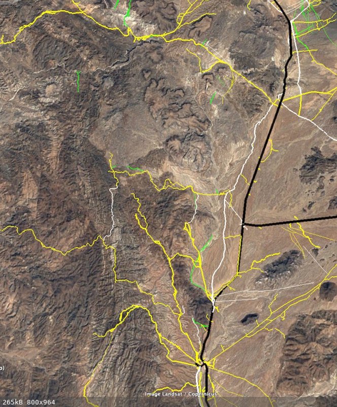
Harald Pietschmann
|
|
|
| Pages:
1
..
4
5
6
7
8
..
10 |


