| Pages:
1
..
3
4
5
6
7 |
bajaric
Senior Nomad

Posts: 605
Registered: 2-2-2015
Member Is Offline
|
|
San Andres is an interesting place. I keep seeing it pop up on various old maps going all the way back to the 1880's as Harald pointed out. It looks
like it is in a wide arroyo with a water source a little east of Santa Rosalillita. One GPS coordinate on this thread put it here: 28°47'04"N
114°10'03"W
On google earth you can see a structure in the bottom of the arroyo a little north of that point. Gerhard and Gulik described San Andres as "an old
cattle ranch, uninhabited in 1961". After that it disappeared off the maps.
What makes San Andres interesting is that it seems to be outside of the mission system, a very early private enterprise in the central desert of Baja.
In the 1800's San Andreas may have been a rancho where cattle were raised for their hides and sold to seagoing traders. This was a common practice in
Alta California prior to 1849 as described in the book Seven Years Before the Mast. Ensenada as well was a "hide rancho" during the period.
Or, San Andres may have just been a water hole, and that is why it is shown on so many maps.
Around 1905 there was a wagon road that went from the landing at Santa Rosalia (aka Santa Rosalillita) to Punta Prieta to supply the mines in the
Sierra Columbia. This wagon road passed by San Andres. It would have been an important source of water and perhaps also beef for the small mining
community at Punta Prieta. You can still trace the wagon road south from Punta Prieta to San Andreas and beyond to Santa Rosalillita. It is a
different route than the modern paved road.
edited for spelling.
also, the Baja California Almanac shows a "San Andres" 2 miles inland from Puerto San Andres, north of Santa Rosalillita (I hate spelling that!) but
this is a different location than shown on Gerhard and Gulik's map, which shows San Andreas as 8 miles inland. The more inland location is probably
the original San Andres, a place that has been known to travelers since the 1750's, way back in the missionary days.
[Edited on 6-6-2023 by bajaric]
|
|
|
4x4abc
Ultra Nomad
Posts: 4174
Registered: 4-24-2009
Location: La Paz, BCS
Member Is Offline
Mood: happy - always
|
|
can't miss San Andres!
Puerto San Andres
Sierra San Andres
Arroyo San Andres
Cañon San Andres
Rancho San Andres
Cerro San Andres
Rancho Bachandres
all within a 5 mile radius
Harald Pietschmann
|
|
|
mtgoat666
Select Nomad
Posts: 17346
Registered: 9-16-2006
Location: San Diego
Member Is Offline
Mood: Hot n spicy
|
|
Quote: Originally posted by 4x4abc  | can't miss San Andres!
Puerto San Andres
Sierra San Andres
Arroyo San Andres
Cañon San Andres
Rancho San Andres
Cerro San Andres
Rancho Bachandres
all within a 5 mile radius
|
It seems like they are fond of saint andrew. saint andrew was greek, perhaps the area was settled by greeks? 
Woke!
“...ask not what your country can do for you – ask what you can do for your country.” “My fellow citizens of the world: ask not what America
will do for you, but what together we can do for the freedom of man.”
Prefered gender pronoun: the royal we
|
|
|
4x4abc
Ultra Nomad
Posts: 4174
Registered: 4-24-2009
Location: La Paz, BCS
Member Is Offline
Mood: happy - always
|
|
this German 1868 map mentions San Andres first
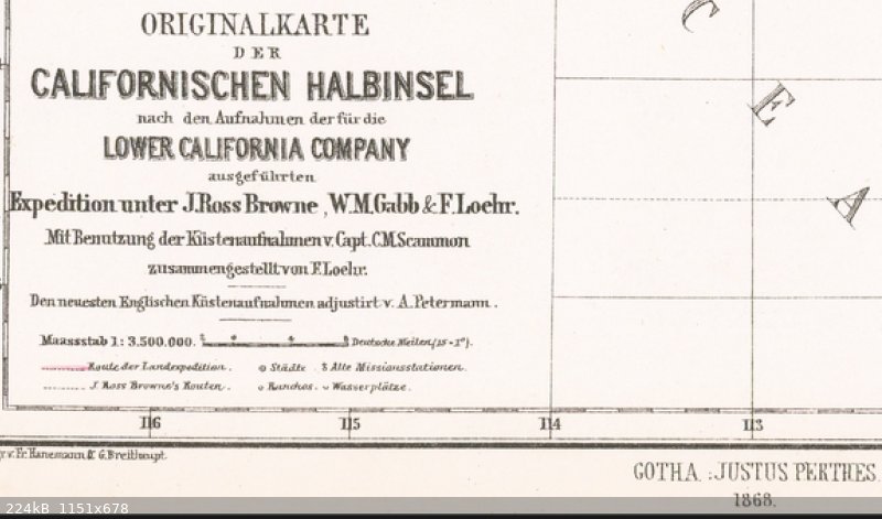
Harald Pietschmann
|
|
|
David K
Honored Nomad
Posts: 64493
Registered: 8-30-2002
Location: San Diego County
Member Is Offline
Mood: Have Baja Fever
|
|
Would you please email the full map to me?
|
|
|
Lance S.
Nomad
Posts: 152
Registered: 2-16-2021
Member Is Offline
|
|
https://www.raremaps.com/gallery/detail/33415/map-of-lower-c...
|
|
|
mtgoat666
Select Nomad
Posts: 17346
Registered: 9-16-2006
Location: San Diego
Member Is Offline
Mood: Hot n spicy
|
|
The Lower California Company - an example proving that yankee imperialism was sometimes not successful or prosperous
Woke!
“...ask not what your country can do for you – ask what you can do for your country.” “My fellow citizens of the world: ask not what America
will do for you, but what together we can do for the freedom of man.”
Prefered gender pronoun: the royal we
|
|
|
David K
Honored Nomad
Posts: 64493
Registered: 8-30-2002
Location: San Diego County
Member Is Offline
Mood: Have Baja Fever
|
|
Thanks Lance, unfortunately, this is one map that Barry doesn't show in the highest resolution. Names blur when you zoom in. Not so in most of his
maps, like this one of Pichilingue, near La Paz, in the early 1900s. Zoom in on the U.S. Coaling station fo detail: https://www.raremaps.com/gallery/detail/71918/pichilinque-ha...
|
|
|
Lance S.
Nomad
Posts: 152
Registered: 2-16-2021
Member Is Offline
|
|
From J.D. Hawks 1849.
We halted , at 11 o'clock , at a small salt - marsh , where we could pick up crystals of beautiful salt , and our shoes and clothing were incrusted
with it . There is a fresh water stream that makes through or rises in the valley or marsh . The water is good , has a slight smell of sulphur , but
is cool and clear , with but a little brackish taste . This is called San Andres , and was once occupied by an American named Gilbert , but who has
abandoned it .
|
|
|
Lance S.
Nomad
Posts: 152
Registered: 2-16-2021
Member Is Offline
|
|
North 1905
The darkness became less intense after midnight , and in order to make the journey as easy as possible for the stock by traveling in the cool early
morning hours , we broke camp at 2 a . m . and continued down the trail . After traveling about 10 miles we reached Punta Prieta , a deserted cattle
ranch . This place had been occupied within a few weeks and we were glad to find a well about 40 feet deep with a bucket and rope , so we were able to
water our stock . Thence we continued about 10 miles farther down the trail to San Andres Ranch , at the ex- treme lower end of the valley . Here the
hills on both sides shut in and reduce the valley to a narrow point from which a short canyon leads through the coast hills to the shore of Playa
Maria Bay . About a mile of the lower end of the valley bad been extensively improved and the ruins of well - made houses , machinery , good wells ,
irrigation ditches , and old fields showed that a large amount of money had been spent here , but the project had evidently been a com- plete failure
and from the ruined condition of the improvements it was plain the place had been abandoned for many years . I have since learned that this
establishment belonged to an English corporation ( Henry Louis & Co. ) , which was operating here in 1887 with the object of making paper from the
datilillo or yucca ( Yucca valida ) , which abounds throughout this region.¹ At the extreme lower end of the valley water lies near enough the
surface to make some wet meadows and to fill a small pond . The green flats and large mesquites gave a welcome change from the desert country we had
traversed , and a short stop was made here to rest the stock . An ocotillo we had not seen before ( Fouquieria peninsularis ) grew in the valley above
San Andres and Idria columnaris was abundant in the valley just above the ranch . Harris's hawk , Scott's oriole , and the black - chinned sparrow (
Spizella atrogularis ) , were common here . A dozen or more Harris's hawks , a species which had not been seen since we left Ensenada , gathered every
day at sunset to roost in the tall cirios near the ranch
|
|
|
Lance S.
Nomad
Posts: 152
Registered: 2-16-2021
Member Is Offline
|
|
Itinerarios y Derroteros 1865 (google translate)
San Andres: The road continues on flat land for the most part and after passing through another small water (Santo Domingo) we reach San Andres over
the same somewhat wrinkled terrain where there is water and grass, a lot of mesquite, and there was Rancho San Borja. It is distant from Rosarito Six
Leagues.
[Edited on 6-8-2023 by Lance S.]
|
|
|
Lance S.
Nomad
Posts: 152
Registered: 2-16-2021
Member Is Offline
|
|
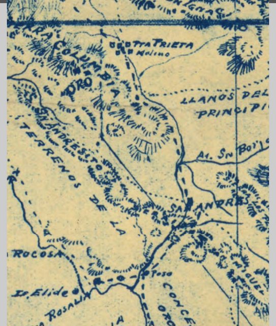
Just noticed that on Goldbaum there is a trail headed north west from San Andres that runs between the Sierra San Andres and the Sierra Columbia.
Just like the road today. So Goldbaum actually has it in the same place as the Baja Almanac. The site nearer the ocean.
[Edited on 6-8-2023 by Lance S.]
[Edited on 1-4-2024 by Lance S.]
|
|
|
Lance S.
Nomad
Posts: 152
Registered: 2-16-2021
Member Is Offline
|
|
Speaking of the Sierra San Andres.
https://www.academia.edu/35589037/Surfing_the_Waves_of_Small...
|
|
|
bajaric
Senior Nomad
Posts: 605
Registered: 2-2-2015
Member Is Offline
|
|
Interesting! Everything you never knew you needed to know about San Andres. Turns out there WAS some private enterprise there in the 1880's, not
herding cattle, but herding yuccas. San Andres was undoubtably an important water source used by early travelers in this area, from Consag in 1751 all
the way to the days of the "49rs" two centuries later. There was probably also a substantial indigenous population centered there who periodically
went over to the coast to feast on shellfish. oops now the secret is out, pretty soon the surfers will show up and start the looting.
|
|
|
David K
Honored Nomad
Posts: 64493
Registered: 8-30-2002
Location: San Diego County
Member Is Offline
Mood: Have Baja Fever
|
|
There also was a potential coal mine near San Andres, or so says a report in 1891. See pages 159-160 of Modest Fortunes ©1992 (#51 of the Dawson Book
series).
Reported to be within three miles of the coast, at San Andres. The coal was described as "coarse sulphur-colored sandstone with plenty of shale. We
tested some of the coal, which burned freely and left a clean white ash".
|
|
|
Lance S.
Nomad
Posts: 152
Registered: 2-16-2021
Member Is Offline
|
|
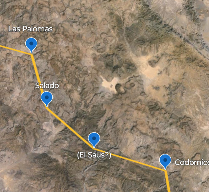
| Quote: Originally posted by 4x4abc |
I can only fill in what I see on the sat images
I have some promising traces between Rancho El Sauce and Laguna El Caporal
but nothing from Salado to El Caporal - all trails there are radiating out from Laguna Chapala
|
Been working on marking this all out. Here is the stretch from Codornices to Las
Palomas as shown on Goldbaum.
[Edited on 4-13-2024 by Lance S.]
|
|
|
Lance S.
Nomad
Posts: 152
Registered: 2-16-2021
Member Is Offline
|
|

 upload image to url upload image to url
|
|
|
David K
Honored Nomad
Posts: 64493
Registered: 8-30-2002
Location: San Diego County
Member Is Offline
Mood: Have Baja Fever
|
|
Hi Lance! 
Nice to have a fun map project to explain history by.
|
|
|
4x4abc
Ultra Nomad
Posts: 4174
Registered: 4-24-2009
Location: La Paz, BCS
Member Is Offline
Mood: happy - always
|
|
Lance,
could you give us the GPS for the locations you put into Google Erath?
Harald Pietschmann
|
|
|
Lance S.
Nomad
Posts: 152
Registered: 2-16-2021
Member Is Offline
|
|
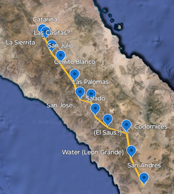
Still same coordinates as my first post on this thread but with a couple of speculative place names and Cerrito Blanco added.
The water between Codornices and Salado is next to Pico El Sauz. Aquaje El Sauz?
The water between San Julio and Catarina is near Cerro Las Casitas, maybe the water source is also called Las Casitas.
|
|
|
| Pages:
1
..
3
4
5
6
7 |


