| Pages:
1
2 |
David K
Honored Nomad

Posts: 64524
Registered: 8-30-2002
Location: San Diego County
Member Is Offline
Mood: Have Baja Fever
|
|
Your Suggested Edits for the Benchmark Maps 2nd edition Baja Atlas
I came across a needed addition and recently sent it to the editors (it was the lobster village of Puerto Nuevo)... apologizing for missing that
omission. The cities and highly touristy areas are just not my thing as I usually breeze through those areas to get to the soul of Baja!
IF you found an place that is missing from the Atlas, or a correction to the Atlas, please submit it here, or in a u2u, or email for Benchmark's
consideration.
I was just happy to hear that a second, updated edition was already in the works. They also plan to send a field worker to confirm data.
Past submitted edits include:
*Campo Los Delfines location is Km. 127, an error from INEGI.
*San Felipe Municipality creation, shortly after the Atlas was published.
*Parallel route to Mission Santa María parallel to part of the way from Santa Ynez.
*Punta Quebrada location near B. Tortugas (from a Baja Nomad)
*Laguna Hanson area road corrections (from a Baja Nomad)
*The years of operation for the final site of the Comondú mission, should be 1736-1827.
Please share your findings so the next Atlas is even better and more accurate than the first!
|
|
|
AKgringo
Elite Nomad
Posts: 5828
Registered: 9-20-2014
Location: Anchorage, AK (no mas!)
Member Is Offline
Mood: Retireded
|
|
Puerto Nuevo missing?
If you are referring to the village north of Bahia Asumcion, it is on page 48 of my Benchmark Atlas. Is there another one, I know that some place
names get used in multiple sites.
I drove through there last fall. I think I was the only tourist around there at the time.
If you are not living on the edge, you are taking up too much space!
"Could do better if he tried!" Report card comments from most of my grade school teachers. Sadly, still true!
|
|
|
geoffff
Senior Nomad
Posts: 644
Registered: 1-15-2009
Member Is Offline
|
|
2023 Notes:
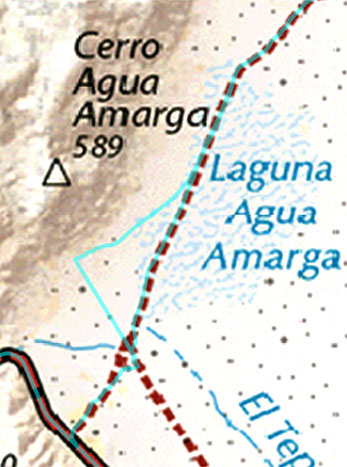
At Agua Amarga, the road Benchmark shows is (mostly) blocked by a new fence. The current best track goes northwest along the southwest side of the
fence to 29.0492, -113.7971 and then turns northeast. I also drove around the south end of the fence, but there wasn't really a road there.
-------
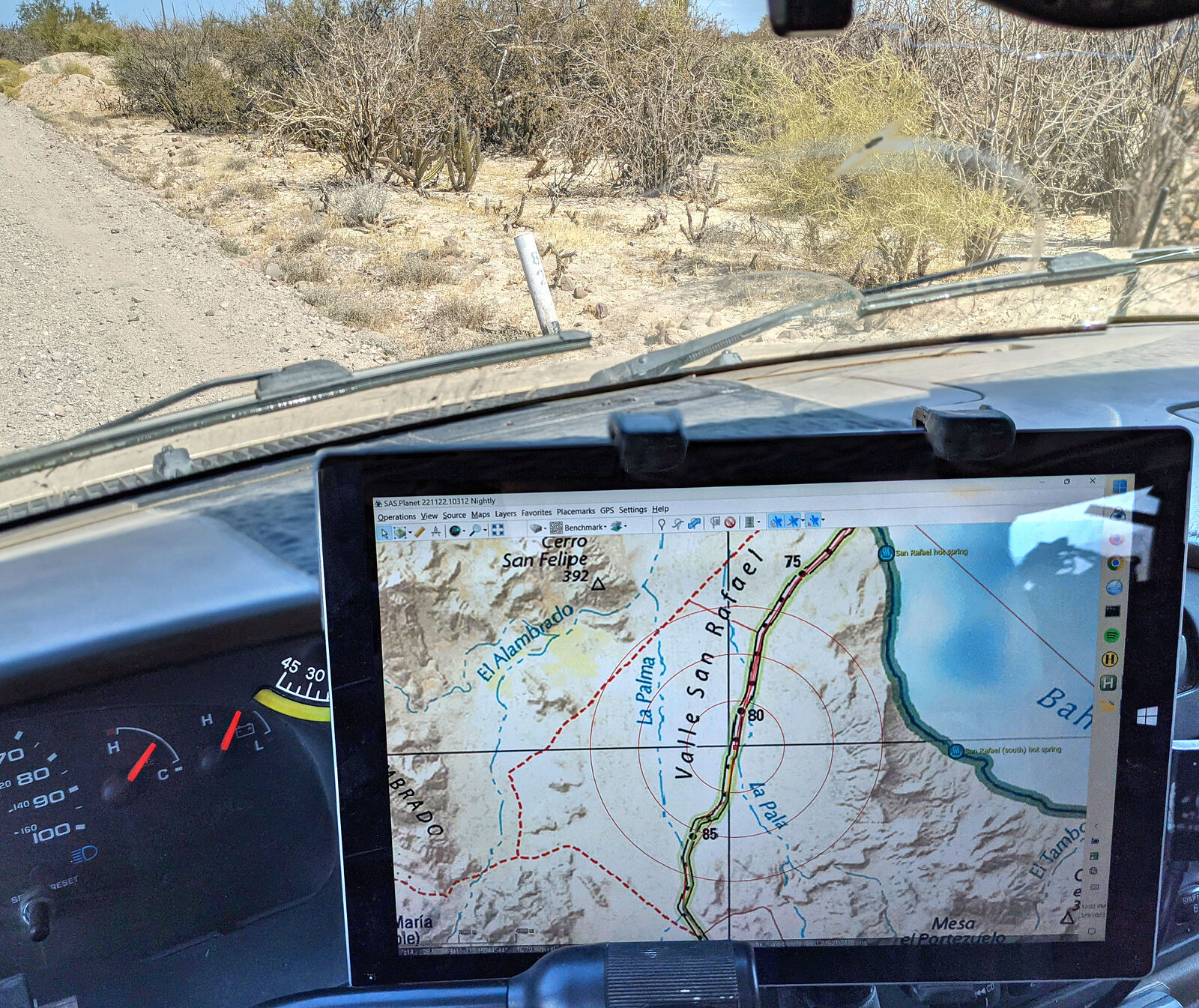
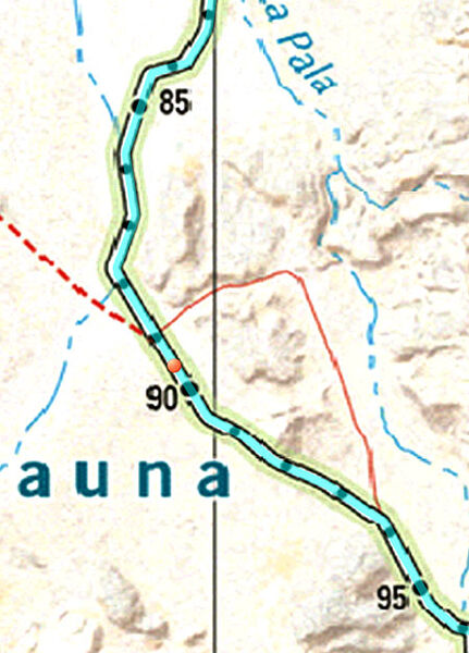
Benchmark shows KM markers along the road south from Bahia de los Angeles to San Francisquito. The Benchmark numbers might be the actual distance, but
they do not match the (incorrectly placed) physical KM markers found along the road. For example, KM marker 89 is here at the orange dot. The
discrepancy increases the further you go. I have some more examples in my notes.
And here is KM82:

-------
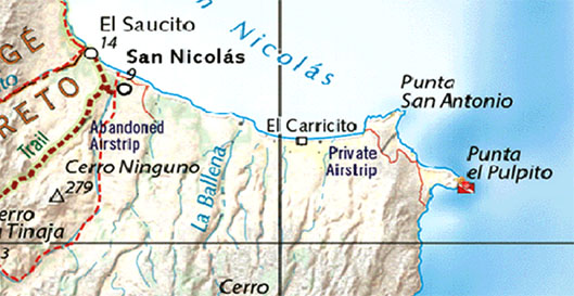
San Nicolas: There is a nice "beach road" (which is often just driving on the beach) which goes all the way east from San Nicolas to Punta el Pulpito.
(26.5178, -111.4426) There is also a new inland road to El Carricito. Do not take this -- it is private.

-------
Minor detail in Ciudad Insurgentes: The east-west road at 25.2821, -111.7650 does not actually connect. The east branch ends at a mostly-fallen fence
and ditch running north-south just west of the intersection. I made the mistake of driving over this anyway (I was impatient), and popped a tire!

-------
The road south of Rancho San Juan going to Comondu Viejo is thoroughly washed out at 26.2798, -111.7240 Cannot drive south from there.

-------
[Edited on 5-9-2023 by geoffff]
|
|
|
PaulW
Ultra Nomad
Posts: 3015
Registered: 5-21-2013
Member Is Offline
|
|
The last edit I sent directly to map staff the response was thanks but the final edit has been sent. That was many months ago. The result is I have
not submitted more suggested edits.
I am waiting for the second edition to show up.
|
|
|
David K
Honored Nomad
Posts: 64524
Registered: 8-30-2002
Location: San Diego County
Member Is Offline
Mood: Have Baja Fever
|
|
AK, let me check that on my PC. Just scanning stuff on my phone, now.
Geoffff, awesome. You know the kilometer points south of L.A. Bay came from your input before the first edition. The road between San Juan and
Comondú Viejo was exactly the same for me in 2017. One kilometer past the ranch, the road crosses the arroyo and was gone. Just before the mission
area it re-crosses the arroyo and was washed out... about a kilometer from the first crossing. I wonder what the road on south to San José Comondú
is like? This was the main road to La Paz, in the 60s. The San Nicolas roads you mention (beach and private inland) don't sound like ones that should
be in the Atlas?
Paul, I don't know who got your emails. Please send to me as I speak directly to the team who do the Baja Atlas. They are in a different state than
the corporate office.
The second edition is in the future and they asked me to provide what I asked for in this post. To get more eyes on this, I also asked my Facebook
groups the same.
Thank you for your interest!
Email to me or post your submissions.
[Edited on 5-7-2023 by David K]
|
|
|
David K
Honored Nomad
Posts: 64524
Registered: 8-30-2002
Location: San Diego County
Member Is Offline
Mood: Have Baja Fever
|
|
Quote: Originally posted by AKgringo  | If you are referring to the village north of Bahia Asumcion, it is on page 48 of my Benchmark Atlas. Is there another one, I know that some place
names get used in multiple sites.
I drove through there last fall. I think I was the only tourist around there at the time. |
Hi AKgringo, no (that one is on the Atlas)... I am speaking of the lobster restaurant village between Rosarito Beach and Cantamar, in the northern
state.
Thanks for asking!
|
|
|
PaulW
Ultra Nomad
Posts: 3015
Registered: 5-21-2013
Member Is Offline
|
|
Benchmark Baja Atlas
Wow, the first announcement came in the summer of 2021 as a request to submit edits and errors.
David was the one who made that request and he gave us contact email to do so. I followed up and was referred to the map guy.
He always thanked me for my input.
|
|
|
mtgoat666
Select Nomad
Posts: 17387
Registered: 9-16-2006
Location: San Diego
Member Is Offline
Mood: Hot n spicy
|
|
Dk:
Lots of good map info in openstreetmap and google, where map info is crowd-sourced.
Woke!
“...ask not what your country can do for you – ask what you can do for your country.” “My fellow citizens of the world: ask not what America
will do for you, but what together we can do for the freedom of man.”
Prefered gender pronoun: the royal we
|
|
|
David K
Honored Nomad
Posts: 64524
Registered: 8-30-2002
Location: San Diego County
Member Is Offline
Mood: Have Baja Fever
|
|
Thanks goat, what I am asking is, if any Nomads want to help make the 2nd edition even better and more accurate than the first, from their personal
observations and travels.
Copying Google (which has always had incorrect or questionable map data) isn't something that I think Benchmark is interested in doing.
|
|
|
AKgringo
Elite Nomad
Posts: 5828
Registered: 9-20-2014
Location: Anchorage, AK (no mas!)
Member Is Offline
Mood: Retireded
|
|
Map errors
Back in the early 70s, my dad cleared a firebreak between our property and the adjoining BLM land. Parts of the break are accessible for any fire
responders, but there are a few steep sections that you wouldn't want to try on anything less capable than his caterpillar!
I don't know if it was a human error, or an algorithm, but it shows up on some map searches as a named road that is an extension of a dead end road to
the north, connecting to another actual (but private) road on my cousin's property.
If you are not living on the edge, you are taking up too much space!
"Could do better if he tried!" Report card comments from most of my grade school teachers. Sadly, still true!
|
|
|
David K
Honored Nomad
Posts: 64524
Registered: 8-30-2002
Location: San Diego County
Member Is Offline
Mood: Have Baja Fever
|
|
| Quote: Originally posted by AKgringo | Back in the early 70s, my dad cleared a firebreak between our property and the adjoining BLM land. Parts of the break are accessible for any fire
responders, but there are a few steep sections that you wouldn't want to try on anything less capable than his caterpillar!
I don't know if it was a human error, or an algorithm, but it shows up on some map searches as a named road that is an extension of a dead end road to
the north, connecting to another actual (but private) road on my cousin's property. |
Yes, and as geoffff pointed out on that road just north of Insurgetes, what looks like a 'through road' may have a 1/2 mile gap rendering it useless!
Thanks for your input!
Maps are only accurate on the day they were researched a hurricane (like Kay) can render any road useless until it is repaired. I just heard from a
Nomad who drove between Comondú and San Javier. He reported that road had a lot of 4WD sections and washouts, since I drove it in 2017. Then, just
the steep grades up and down from the mesa between Palo Chino and El Horno needed extra traction and slow driving... and was smoothed out after that
trip, I read.
Thanks to all of you with your input. If I learn when the 2nd edition is planned to be published, and I am allowed to say, you will be informed.
|
|
|
geoffff
Senior Nomad
Posts: 644
Registered: 1-15-2009
Member Is Offline
|
|
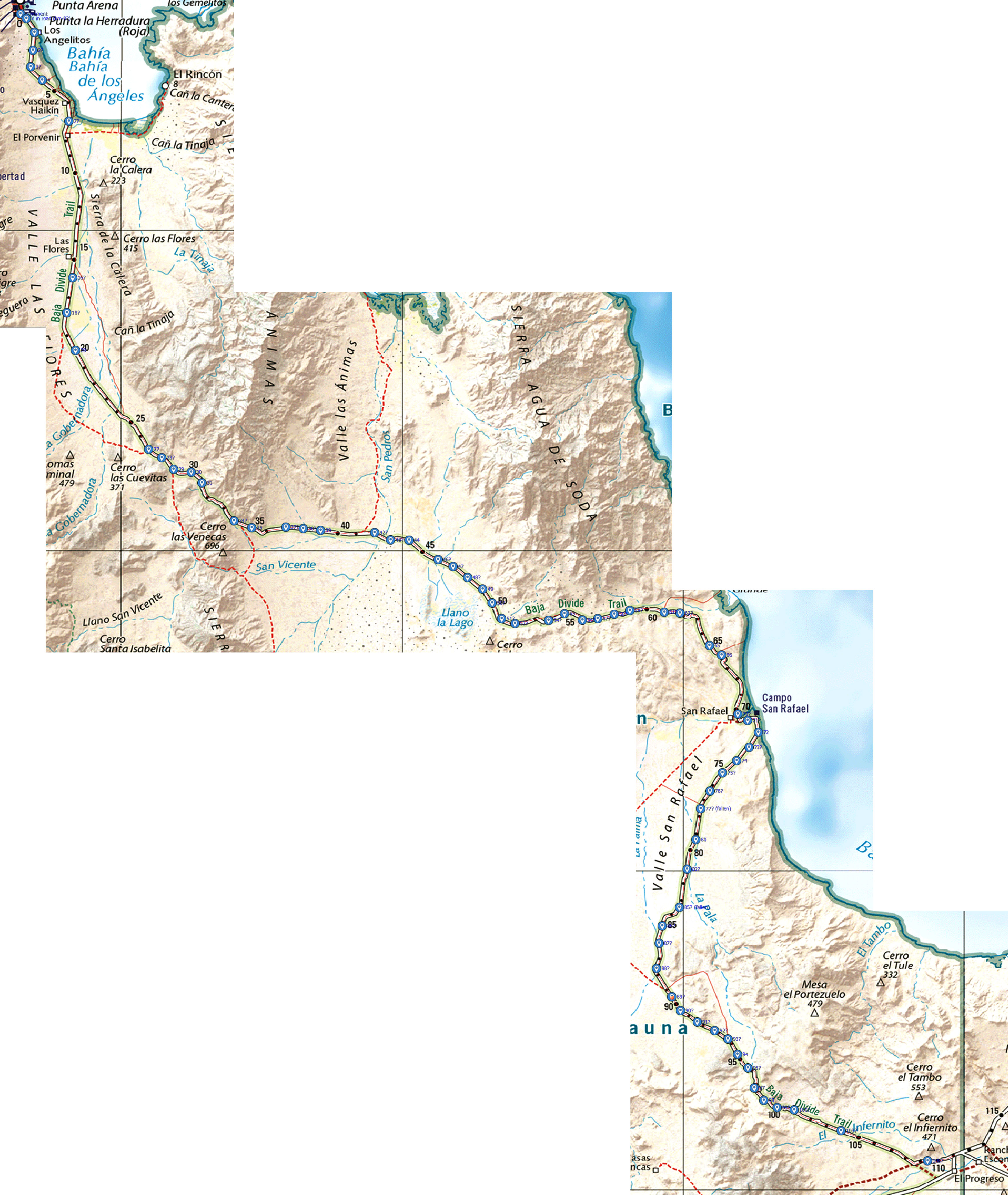
| Quote: Originally posted by David K | | Geoffff, awesome. You know the kilometer points south of L.A. Bay came from your input before the first edition. |
I was wondering about that. However, their final map doesn't seem to match the numbers I gave you, at least not past Campo San Rafael:
28.9456 -113.5602 pavement in BOLA
28.9432 -113.5567 000 (Y in road)
28.9361 -113.5519 001
28.9267 -113.5528 002?
28.9182 -113.5541 003?
28.9113 -113.5472 004
28.8900 -113.5315 007?
28.8086 -113.5293 016?
28.7904 -113.5327 018?
28.7709 -113.5276 020
28.7193 -113.4841 027
28.7149 -113.4763 028?
28.7090 -113.4693 029
28.7074 -113.4589 030
28.7019 -113.4526 031
28.6821 -113.4335 034?
28.6785 -113.4229 035
28.6788 -113.4027 037?
28.6781 -113.3925 038?
28.6771 -113.3821 039
28.6759 -113.3501 042?
28.6722 -113.3406 043?
28.6721 -113.3296 044
28.6619 -113.3124 046?
28.6584 -113.3035 047
28.6527 -113.2949 048?
28.6466 -113.2860 049
28.6394 -113.2803 050?
28.6312 -113.2747 051?
28.6287 -113.2668 052?
28.6303 -113.2468 054?
28.6337 -113.2374 055
28.6305 -113.2268 056?
28.6312 -113.2177 057?
28.6335 -113.2080 058?
28.6355 -113.1986 059?
28.6345 -113.1782 061?
28.6341 -113.1689 062?
28.6172 -113.1514 065
28.6122 -113.1443 066
28.5815 -113.1346 070?
28.5782 -113.1288 071?
28.5720 -113.1224 072
28.5641 -113.1279 073?
28.5572 -113.1354 074
28.5509 -113.1437 075?
28.5413 -113.1511 076?
28.5322 -113.1566 077? fallen
28.5161 -113.1596 080
28.5007 -113.1647 082?
28.4808 -113.1692 085? fallen
28.4710 -113.1793 086?
28.4620 -113.1813 087?
28.4489 -113.1829 088?
28.4341 -113.1738 089?
28.4268 -113.1686 090?
28.4210 -113.1587 091?
28.4164 -113.1483 092?
28.4121 -113.1405 093?
28.4041 -113.1347 094
28.3970 -113.1287 095?
28.3866 -113.1248 097
28.3800 -113.1191 098
28.3762 -113.1113 099?
28.3750 -113.1012 100?
28.3642 -113.0733 103?
28.3485 -113.0219 108?
Here are my KM marker locations overlaid on the Benchmark map. Click images to enlarge:

|
|
|
geoffff
Senior Nomad
Posts: 644
Registered: 1-15-2009
Member Is Offline
|
|
| Quote: Originally posted by David K | | Yes, and as geoffff pointed out on that road just north of Insurgetes, what looks like a 'through road' may have a 1/2 mile gap rendering it useless!
|
In this case, the gap is small -- a recent change, perhaps? Worth looking at the satellite imagery (25.2821, -111.7650):

|
|
|
geoffff
Senior Nomad
Posts: 644
Registered: 1-15-2009
Member Is Offline
|
|
| Quote: Originally posted by David K | | The San Nicolas roads you mention (beach and private inland) don't sound like ones that should be in the Atlas? |
I would put the beach road going east from San Nicolas into the atlas - especially since Benchmark already has the east part of this road in there
(26.5243,-111.4646). The beach road is not private.
-- Geoff
|
|
|
geoffff
Senior Nomad
Posts: 644
Registered: 1-15-2009
Member Is Offline
|
|
| Quote: Originally posted by David K | | The road between San Juan and Comondú Viejo was exactly the same for me in 2017. One kilometer past the ranch, the road crosses the arroyo and was
gone. Just before the mission area it re-crosses the arroyo and was washed out... about a kilometer from the first crossing. I wonder what the road on
south to San José Comondú is like? |
The road looks to be in good shape (if not traveled for a long time), but I suspect it is washed out at each additional arroyo it crosses.
You can see the road is still in good shape heading south from Comondu Viejo:
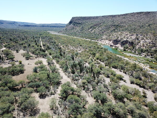
Wow! It's not an easy road, especially just north of the ranch.
|
|
|
geoffff
Senior Nomad
Posts: 644
Registered: 1-15-2009
Member Is Offline
|
|
Unlike Openstreetmaps, Google isn't crowdsourced as far as I know. Google's map is copyrighted. Benchmark would be stung hard if they tried copying
it. Despite being crowdsourced, I don't believe they can legally copy Openstreetmaps either!
[Edited on 5-8-2023 by geoffff]
|
|
|
David K
Honored Nomad
Posts: 64524
Registered: 8-30-2002
Location: San Diego County
Member Is Offline
Mood: Have Baja Fever
|
|
I remember in 1966 that there was a steep grade just south of your photo, heading to the twin Comondú towns. We got a case of 'vapor lock' on that
grade (it was summer). The 327 V8 Wagoneer with AC just wouldn't start.
Along comes a much older, Willys-Overland station wagon, driven by a local, with his son. Since the main highway to La Paz here was just one lane
wide, low range 4WD on this part, and no way around on a mountain grade, the Willys driver offered to assist.
He opened the Wagoneer hood, and was really overwhelmed by how full the engine compartment was, compared to his 4 banger with plenty of space under
his hood!
Anyway, the Wagoneer fired up once again thanks to the friendly and helpful Willys man.
|
|
|
David K
Honored Nomad
Posts: 64524
Registered: 8-30-2002
Location: San Diego County
Member Is Offline
Mood: Have Baja Fever
|
|
Benchmark wants to hear from us
I am amazed at your work with the kilometer posts south of L.A. Bay, Geoffff!
I will make sure Benchmark sees this... I just saw it today and didn't know I missed seeing the whole thread before today! I will forward it to
Benchmark now. So far, the input from Nomads and my Facebook group members has been great and Benchmark emailed me twice... Here they are:
[Edited on 5-11-2023 by David K]
|
|
|
geoffff
Senior Nomad
Posts: 644
Registered: 1-15-2009
Member Is Offline
|
|
Regarding the KM markers south of Bahia de los Angeles.
All the KM markers in my list were ones I spotted by going back over my georeferenced dash-cam images. These images were from a March 2019 road trip,
for which my cameras (front and rear) took photos once every 10 seconds.
I put "?" in my list next to markers for which I couldn't read the actual number on the marker. The marker may have been oriented
wrong, partially obscured, or too distant. But in each case, a marker was there.
Some markers have fallen, such as km89 (as of 2023). I have no reason to believe anyone would have bothered to move a marker to a new location.
You will see that the markers in my list are reasonably consistently spaced, so I presume their placement was intentional, not random error.
Something odd happens between km71 and km89, where the markers (while consistently spaced) don't seem to be 1km apart. My guess is that the road used
to follow a different route here, and they didn't bother moving/updating all the subsequent km markers when the road was re-routed to a longer path
here.
[Edited on 5-11-2023 by geoffff]
|
|
|
geoffff
Senior Nomad
Posts: 644
Registered: 1-15-2009
Member Is Offline
|
|
I've lost track of these images over the years, but I could find them again if needed.
--------------
Here are some example images:
Two images for KM4


--------------
KM20
|
|
|
| Pages:
1
2 |