| Pages:
1
2 |
4x4abc
Ultra Nomad

Posts: 4165
Registered: 4-24-2009
Location: La Paz, BCS
Member Is Offline
Mood: happy - always
|
|
Quote: Originally posted by geoffff  | | Quote: Originally posted by David K | | The San Nicolas roads you mention (beach and private inland) don't sound like ones that should be in the Atlas? |
I would put the beach road going east from San Nicolas into the atlas - especially since Benchmark already has the east part of this road in there
(26.5243,-111.4646). The beach road is not private.
-- Geoff |
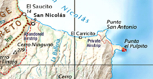
Cerro Ninguno does not exist
Harald Pietschmann
|
|
|
4x4abc
Ultra Nomad
Posts: 4165
Registered: 4-24-2009
Location: La Paz, BCS
Member Is Offline
Mood: happy - always
|
|
the correct name is Llano la Laguna
Cerro la Laguna right next to it is a good indicator

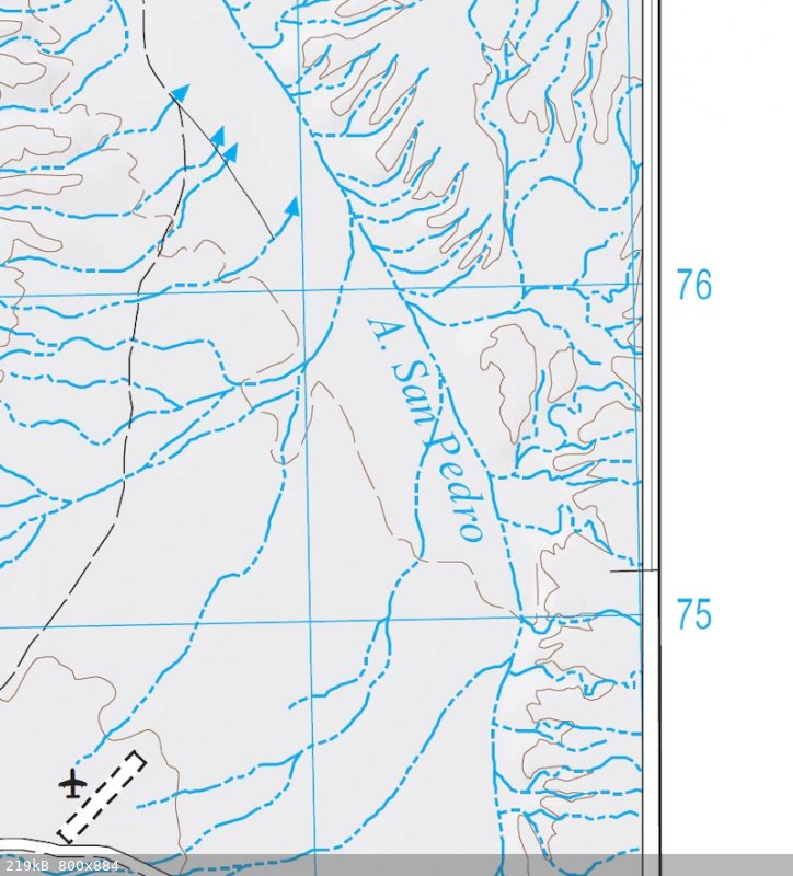
the Arroyo leading to Las Animas is San Pedro - not San Pedros
Harald Pietschmann
|
|
|
David K
Honored Nomad
Posts: 64490
Registered: 8-30-2002
Location: San Diego County
Member Is Offline
Mood: Have Baja Fever
|
|
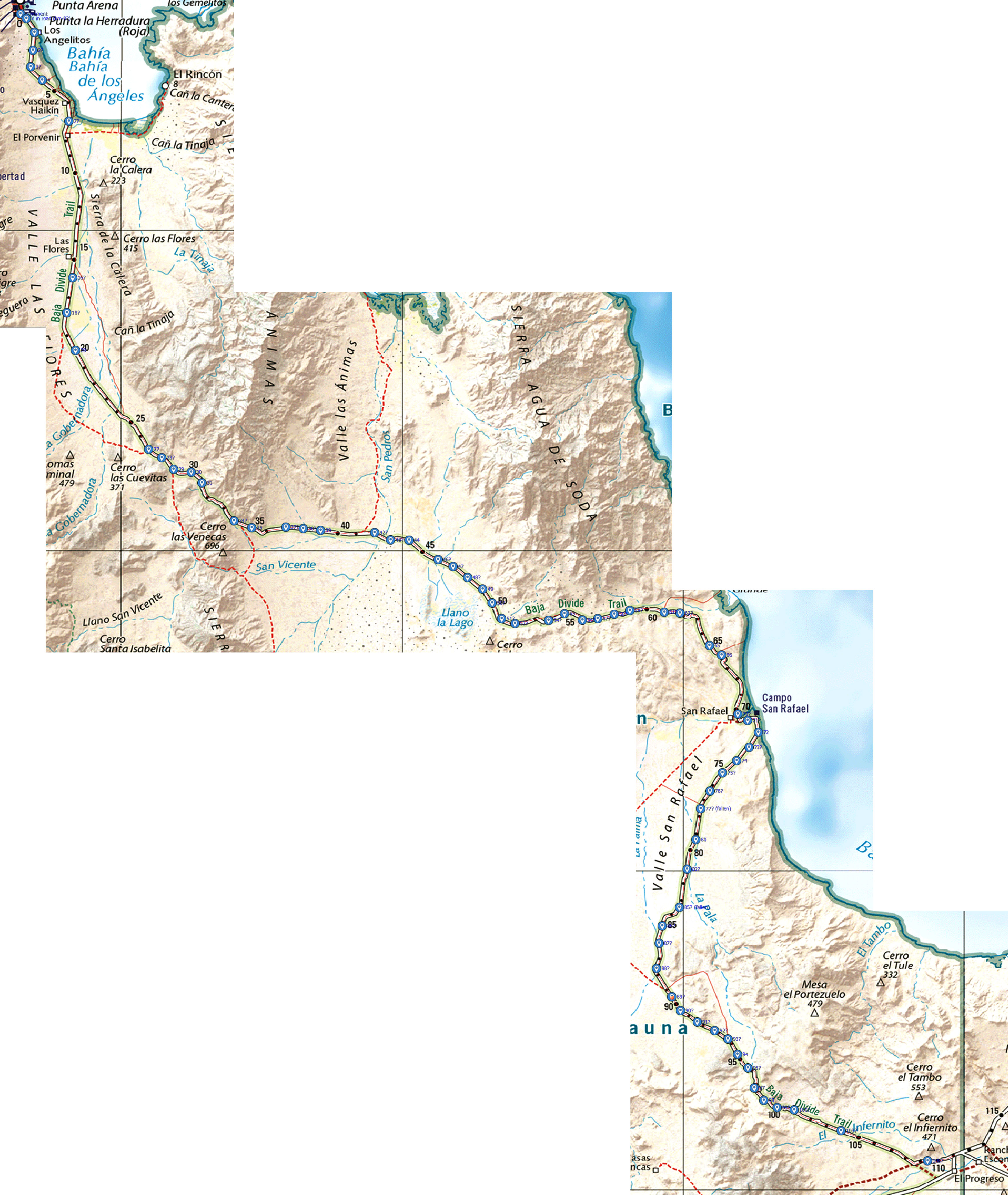
Good eye, Harald... Since the base map used is the Mexican government INEGI maps, are these 'errors' also on them? I will take a look as I am one of
those who bought your topo map package.

|
|
|
4x4abc
Ultra Nomad
Posts: 4165
Registered: 4-24-2009
Location: La Paz, BCS
Member Is Offline
Mood: happy - always
|
|
| Quote: Originally posted by David K | Good eye, Harald... Since the base map used is the Mexican government INEGI maps, are these 'errors' also on them? I will take a look as I am one of
those who bought your topo map package.
|
I know how much you love INEGI
that's why I checked before I posted
the names pointed out are either non existent on the INEGI maps or they are correct
H12C62 for Arroyo San Pedro
G12A68 for Cerro Ninguno
Caltopo is the quickest way to check:
https://caltopo.com/map.html#ll=28.72681,-113.35043&z=15...
[Edited on 5-11-2023 by 4x4abc]
Harald Pietschmann
|
|
|
David K
Honored Nomad
Posts: 64490
Registered: 8-30-2002
Location: San Diego County
Member Is Offline
Mood: Have Baja Fever
|
|
I was trying to plug your product!
'Cerro Ninguno' is showing as Cerro Bola: https://caltopo.com/map.html#ll=26.51207,-111.56891&z=15...
|
|
|
4x4abc
Ultra Nomad
Posts: 4165
Registered: 4-24-2009
Location: La Paz, BCS
Member Is Offline
Mood: happy - always
|
|
Cerro Bola is on the other side of the road
there is a hill allright where the Cerro Ninguno marker is - only it has no name (like most mountains in Baja)
thank you for plugging my map set!
Harald Pietschmann
|
|
|
geoffff
Senior Nomad
Posts: 643
Registered: 1-15-2009
Member Is Offline
|
|
Hah! Ironic name
Harald, they should hire you to do a quick pass looking at every part of the atlas!
|
|
|
geoffff
Senior Nomad
Posts: 643
Registered: 1-15-2009
Member Is Offline
|
|
Here's a GPX file I made of the KM markers I spotted in 2019:
km-markers-south-of-BOLA.gpx
[Edited on 5-11-2023 by geoffff]
|
|
|
4x4abc
Ultra Nomad
Posts: 4165
Registered: 4-24-2009
Location: La Paz, BCS
Member Is Offline
Mood: happy - always
|
|
I would very much like that.
Harald Pietschmann
|
|
|
4x4abc
Ultra Nomad
Posts: 4165
Registered: 4-24-2009
Location: La Paz, BCS
Member Is Offline
Mood: happy - always
|
|
working with place names for many years I found something interesting
only if there was a need for naming a mountain, or an Arroyo, or something else - only then they would be named.
That translates to the following:
if an area has a lot of named Arroyos, mountains, Mesas - then there was significant human activity (hunting, growing, traveling)
if an area has majestic mountains and gorgeous canyons, but none of them are named - then it was an area where humans, did not hunt, travel or live.
A very large number of places have travel related names (Cuesta, Pie, Portezuelo, Potrero, Puerta, Puerto, Las Juntas)
If you want to find Camino Real without Harry Crosby, look for "La Cuesta Vieja", "Mesa el Potrero", "Arroyo el Pie de la Cuesta", "Tinaja de Los
Frailes" etc
even if the INEGI maps do not show a trail where you find those names - zoom in on Google Earth and there will be a trail
I guarantee it
too bad Crosby did not have Google Earth
Harald Pietschmann
|
|
|
PaulW
Ultra Nomad
Posts: 3009
Registered: 5-21-2013
Member Is Offline
|
|
Way to much concentration on KM marking. Most of us ignore them and concentrate on roads and places.
Move on.
More importantly tell us about misplaced roads, road labels, and places. That is one the major issues with INEGI which is the basis of all
versions of maps regardless of who printed them or put them on a GPS map file.
|
|
|
David K
Honored Nomad
Posts: 64490
Registered: 8-30-2002
Location: San Diego County
Member Is Offline
Mood: Have Baja Fever
|
|
| Quote: Originally posted by 4x4abc |
Cerro Bola is on the other side of the road
there is a hill allright where the Cerro Ninguno marker is - only it has no name (like most mountains in Baja)
thank you for plugging my map set! |
Anytime!
Let's see how I got Cerro Bola from what I though (at a glance) was the Cerro Ninguno location:
I put the + right on top of the triangle for Cerro Ninguno (using the digital Atlas) and I get this GPS: 26.5131, -111.5714
If you plug that GPS into Caltopo or any digital INEGI map, you get:
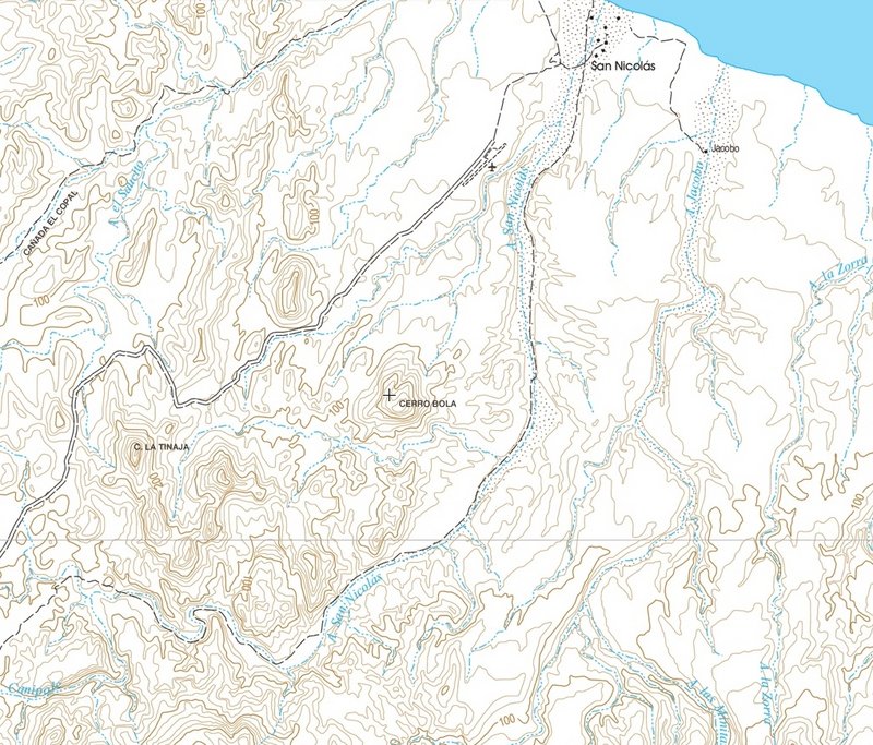
The EXACT same mountain but called Cerro Bola
|
|
|
David K
Honored Nomad
Posts: 64490
Registered: 8-30-2002
Location: San Diego County
Member Is Offline
Mood: Have Baja Fever
|
|
| Quote: Originally posted by PaulW | Way to much concentration on KM marking. Most of us ignore them and concentrate on roads and places.
Move on.
More importantly tell us about misplaced roads, road labels, and places. That is one the major issues with INEGI which is the basis of all
versions of maps regardless of who printed them or put them on a GPS map file. |
I think not, unless you are GPS/Map nerd (like us in this thread)!
With km. markers, you don't need GPS or even an accurate odometer.
If you're looking for a turnoff between Km. 89 and Km. 90 (on the Benchmark map), you just drive to the first posted km. sign of the two and begin
looking for your road. A kilometer is only 0.62 of a mile long.
Even bad odometers will be pretty close in the 0.0 to 0.6 span.
If your road is in between the two, then only 0.3 is passed for 1/2 km. on your odometer (if your road is really faint of brush obscured).
No need for lots of math or electronics... just find that road to your secret beach off the highway, fast and easy! Viva the kilometer points on the
Benchmark Atlas!
As for the rest of your comments... I think we can do it all... I know I am not bothered by helping make a better map. No need to drop one item to
have the others. Let's fix all issues!
[Edited on 5-11-2023 by David K]
|
|
|
PaulW
Ultra Nomad
Posts: 3009
Registered: 5-21-2013
Member Is Offline
|
|
For the main highways what we now have with David's KM list is more than adequate for everyone's use. The hiccups of missing markers and errors are
easy to deal with.
I was a great improvement of Atlas vs Almanac.
When you leave the highways the maps count and they should be better. That is most important.
Good paper maps and backed up with electronic maps make it best of all. I have been using my GPS maps with highway KMs noted since about 2004 or 5 and
have not noted any issues I could not resolve.
The KM markers in the back country were lost years ago.
Remember the days when Bruce Barber gave directions along Morelia/Saltito, and east/west valley roads with a list like David's with KMs and turn
locations. Now days maps work but KM do not work off the highways.
|
|
|
mtgoat666
Select Nomad
Posts: 17335
Registered: 9-16-2006
Location: San Diego
Member Is Offline
Mood: Hot n spicy
|
|
| Quote: Originally posted by PaulW | Way to much concentration on KM marking. Most of us ignore them and concentrate on roads and places.
Move on.
More importantly tell us about misplaced roads, road labels, and places. That is one the major issues with INEGI which is the basis of all
versions of maps regardless of who printed them or put them on a GPS map file. |
Agree. Nice to have a km data for intersections (or infrequent major landmarks), but anything more is clutter.
Woke!
“...ask not what your country can do for you – ask what you can do for your country.” “My fellow citizens of the world: ask not what America
will do for you, but what together we can do for the freedom of man.”
Prefered gender pronoun: the royal we
|
|
|
David K
Honored Nomad
Posts: 64490
Registered: 8-30-2002
Location: San Diego County
Member Is Offline
Mood: Have Baja Fever
|
|
| Quote: Originally posted by PaulW | For the main highways what we now have with David's KM list is more than adequate for everyone's use. The hiccups of missing markers and errors are
easy to deal with.
I was a great improvement of Atlas vs Almanac.
When you leave the highways the maps count and they should be better. That is most important.
Good paper maps and backed up with electronic maps make it best of all. I have been using my GPS maps with highway KMs noted since about 2004 or 5 and
have not noted any issues I could not resolve.
The KM markers in the back country were lost years ago.
Remember the days when Bruce Barber gave directions along Morelia/Saltito, and east/west valley roads with a list like David's with KMs and turn
locations. Now days maps work but KM do not work off the highways. |
Good morning Paul,
True that kilometer markers on dirt roads seem to be less stable. They are on concrete posts rather than metal signs. They are also rare with the road
south of L.A. Bay being the odd one of just a couple having them. I think the road from San Javier to Hwy. 53/ Santo Domingo, is another... I have not
driven that one, so unless someone here can confirm, I just trust the Mexican government map source Benchmark uses on that.
The L.A. Bay south road was traveled by me twice in 2017 and there were no kilometer posts then. It was 'geoffff' in 2019 who recorded them. As you
say, they seem to get knocked over, making them useless for navigating. But they are approx. 1 km. apart and too heavy to steal, so they lay there.
Back to the post subject. Please indicate where errors or omissions are on the 2021 Atlas so the next one will be even better. I realize Hurricane Kay
(last September) really messed up roads in 2/3 of the peninsula. What were 'dirt highways' (like the road south of L.A. Bay) became rutted, washed out
rough roads. Things change and Mexico's highway departments are probably underfunded to deal with repairs or regrading in a timely matter, taking
years to return the road to its former glory. That said, if you think the road classifications, as shown, should be updated, let me know.
Here's an edit suggestion I got on my Facebook group page that may be of interest to Nomads:
Show the original Coco's Corner (1987-2021) as a historic point-of-interest.
The new Coco's Corner (April 2021+, at Las Arrastras) continues to be open for business following Coco's death on August 30, 2021.
Thanks Paul, Geoff, and others, for you valuable input!
|
|
|
PaulW
Ultra Nomad
Posts: 3009
Registered: 5-21-2013
Member Is Offline
|
|
I find it useful to see abandoned places on maps. I do not want to forget such places so I like the reminder. That is also be true for some back
country roads and mines as well.
|
|
|
| Pages:
1
2 |