PaulW
Ultra Nomad

Posts: 3017
Registered: 5-21-2013
Member Is Offline
|
|
Old map Baja as a peninsula
I have been gong to do a search and finally got to it.
Here are my results for the oldest I could find.
Contribute older if you have anything.
Google Search for the oldest map showing Baja as a peninsula.
An expedition commanded by Nuñez de Guzmán and dispatched by the Spanish conquistador Hernán Cortés reached the gulf in 1532 but did not realize
that it was a gulf. Three years later Cortés himself led a second party across the gulf to the Baja peninsula, which was then believed to be an
island. In 1539 Spanish explorer Francisco de Ulloa proved that Baja California was a peninsula rather than an island, and he named the gulf Mar
Bermejo (“Vermilion Sea”) because of the impressive red plankton that is found in its waters. Nevertheless, the myth that the gulf was an island
perpetuated into the 18th century.
Came up with a map on Wikipedia of an explorer named who sailed in 1539

https://exhibits.stanford.edu/ruderman/catalog/jx771jp5969
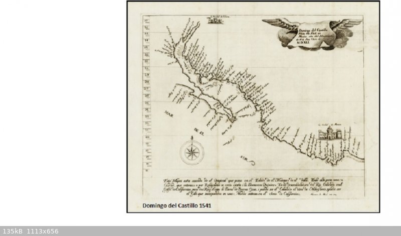
• Fine example of Domingo del Castillo's map of Mexico, which appeared in Lorenzana's Historia de Nueva-España, escrita por su esclarecido
conquistador Hernan Cortes, aumentada con otros documentos, y notas, por el Ilustrissimo Señor Don Francisco Antonio Lorenzana, Arzobispo de Mexico.
Domingo del Castillo's manuscript map of 1541, as reproduced by Lorenzana in 1770, was the first map to establish definitively that California was in
fact a peninsula and not an island. Originally drawn during the Alarcon Voyage to California in 1541. Castillo's map has been called "the oldest and
most interesting cartographical document on California which we have." As noted by J.G. Kohl in his Descriptive Catalogue of those Maps, Charts and
Surveys Relating To America Which Are Mentioned in Vol. III of Hakluyt's Great Work (Washington, 1857). Two of the principal early exploring
expeditions of the gulf and peninsula of California were undertaken by Francisco de Ulloa (1539) and Fernando Alarcon, (1540,) of which the first was
sent out by Hernan Cortes and the second by the Viceroy of Mexico, Mendoza, Cortes's successor in command. . . . The . . . voyage under Alarcon ranged
like the first along the eastern and western shore of the inner gulf, ascertaining better then Ulloa the nature of the northern end of the gulf and of
exploring the great river Colorado, which he asserts to have sailed up for eighty-five leagues. Both Ulloa and Alarcon appear to have made a very good
survey and research. Both were accompanied by good pilots—Ulloa by one Juan Castillo* and Francisco Preciado, who wrote the report on this voyage of
Alarcon by one Nicolas Zamorano, his Piloto Mayor and "Dominico del Castillo,"^ which latter made the chart to that voyage, of which we will speak
instantly. The reports on both voyages are so ably and clearly written as few journals of that time . . . The report on the second voyage is written
by the Commander Alarcon himself. Both were printed for the first time in Ramusio, from which Hakluyt took them. . . . The original charts of both
voyages are, however lost to us. But the pilot of the second or Alarcon's expedition, Dominico del Castello, as he is called in Hakluyt, or "Domingo
del Castillo," as he calls himself, compiled after the second voyage, in the year 1541, in Mexico, a little chart of the visited coasts, for which he
appears to have used the sketches and materials collected on both voyages. This chart was preserved and hidden for a long: time in the archives of the
descendants of Cortes, until, after the middle of the eighteenth century, the Bishop Lorenzano found it there, copied it, and published an engraving
of it in his well-known work on Mexico. It has the following inscription: "Domingo del Castillo, Piloto, me fecit en Mexico aiio del Nacimiento de N.
S. Christo de MDXLI." (Domingo del Castillo, pilot, made me in Mexico in the year of the birth of our Saviour, 1541.) This chart is particularly rich
in names on the eastern shore of the Gulf of California, or on the coasts of Mexico, Cinaloa, and Sonora. [Alarcon] sounded there, measured distances,
and observed the geographical position, and probably made a large special map of it. He requested there even an intelligent Indian, with whom he
conversed, "to set him downe in a charte as much as he knew concerning that river;" "which this Indian did willingly." In our little general sketch
these parts have been treated very generally. That, however, the charts of Arlacon were used is evident from the circumstance that two principal
branches of the Rio Colorado have received the names "Rio de Buena Guia" and " Brazo de Miraflores," names which do not occur in Ulloa's reports, but
only in that of Alarcon. Castillo puts down upon his chart the northern end of the Gulf and the mouth of the Rio Colorado under about 34° N. L., in
harmony with Alarcon's observation, who says about this in his report the following: "By the situation of the river, and by the height -which I took,
I finde that that which the masters and pilots of the Marquesse (Ulloa, Cortes's captain) took is false, and that they were deceived by two degrees,
and I have sayled beyond them above four degrees."* According to this, I said, Castillo puts down the northern end of the Gulf in 34° N. L. This is
more than two degrees higher than the true latitude which we have on our present maps; and if, as it appears from Alarcon's journal, Ulloa had this
latitude, he must have been a much better observer, and we must regret it so much more that we do not possess at present his original charts. It is to
be observed that there is a spirit of boasting in the reports of Alarcon, and that there was a feeling of emulation and envy between him and his
predecessor, Ulloa, naturally growing out of the circumstance, that they were sent upon the same errand—" to find out the secret of the Gulf." This
invidious feeling was probably still enhanced by the other circumstance that Ulloa was commissioned by Cortes and Alarcon by Mendoza, the successor
and. in a certain degree, opponent of Cortes. Alarcon wished to surpass Ulloa in every respect. The coast of the peninsula of California towards the
main ocean, which was not seen at all by Alarcon, is put down in Castillo's chart after the charts of Ulloa. We find here the names "Punta de la
Trinidad," "Pto de Senabad," "the islands of St. Estevan," of which one was the Island of Ceders, (Isle de Cedros,) to which on our chart is written
the name " Pto de reparo," (the harbor of careening or caulking,) because Ulloa repaired and caulked there one of his ships and the "Cabo del
Engaiio." The latitudes are in this part of the chart much too low. The St. Stephen's islands are put in the latitude of 26,° whilst they stand in
27°; and the Caho del Engano is put in 27°, whilst Ulloa appears to place* the cape which he called so in 30° 31\ The same invidious and boasting
feeling which induced Alarcon and his pilot (Castillo) to extend the interior of the Gulf, which they considered to be their own discovery, two
degrees further to the nor th, induced them probably also to bring the ne plus ultra of Ulloa further down to the south.
|
|
|
David K
Honored Nomad
Posts: 64540
Registered: 8-30-2002
Location: San Diego County
Member Is Offline
Mood: Have Baja Fever
|
|
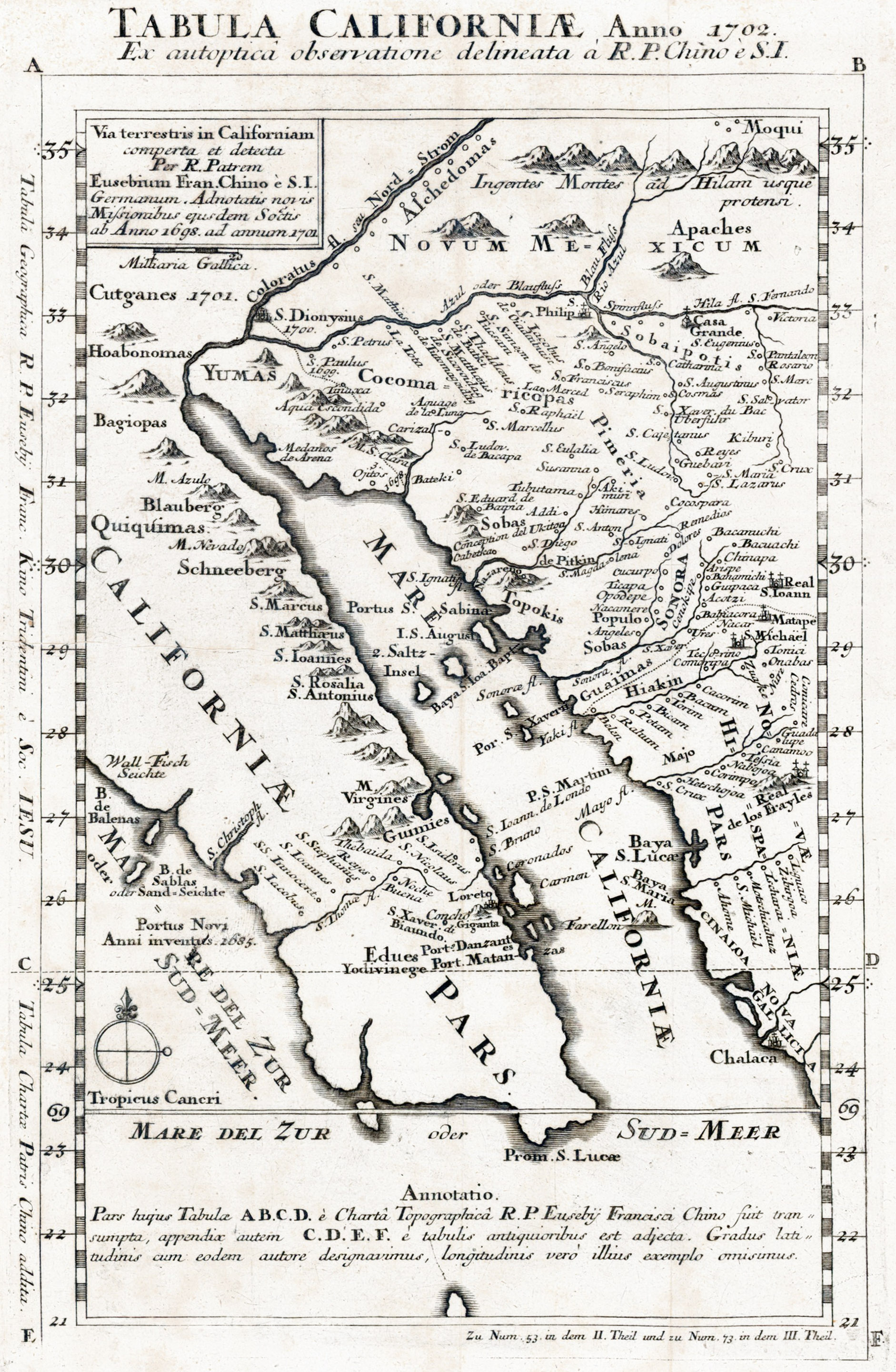
Padre Kino Maps 1701, 1702
Once Kino and Salvatierra traveled to see the Colorado Delta, his maps began showing California as a peninsula...

|
|
|
BajaNomad
|
Thread Moved
1-15-2024 at 03:12 PM |
|


