| Pages:
1
2 |
David K
Honored Nomad

Posts: 64521
Registered: 8-30-2002
Location: San Diego County
Member Is Offline
Mood: Have Baja Fever
|
|
The 1684 Atondo-Kino "First from the Gulf to the Pacific" route
This was a major expedition from the colony at San Bruno (15 miles north of Loreto) to the opposite coast. Ron Ives made a map if the route in 1960
and it appears in the Dawson Volume #16 which is the Admiral Atondo diary, translated by Dr. Michael Mathes.
Unfortunately, the map is not perfect, doesn't include all the overnight stops, but does give an idea of where the 50+ men, horses, mules, and gifts
for the Natives traveled.
Please enjoy my work on this: https://vivabaja.com/atondo-kino/
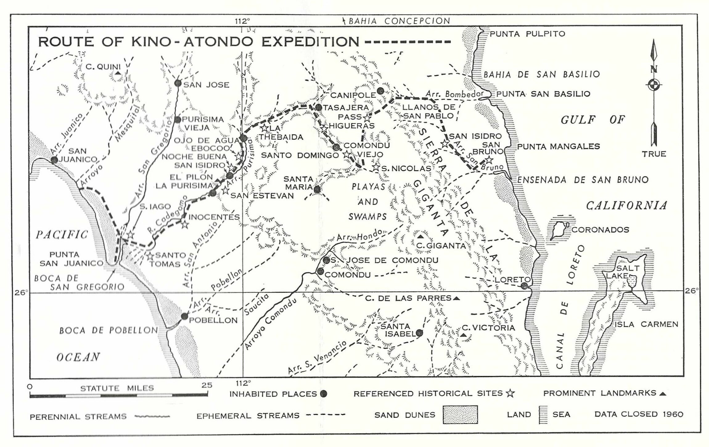
One of the 11 Satellite maps with my track line of the (possible/ likely/ logical) route of travel:
https://vivabaja.com/atondo-kino/
|
|
|
Tioloco
Super Nomad
Posts: 1482
Registered: 7-30-2014
Member Is Offline
|
|
Pretty interesting. Hard to imagine the level of difficulty at that time. A tough group of people for sure.
|
|
|
4x4abc
Ultra Nomad
Posts: 4196
Registered: 4-24-2009
Location: La Paz, BCS
Member Is Offline
Mood: happy - always
|
|
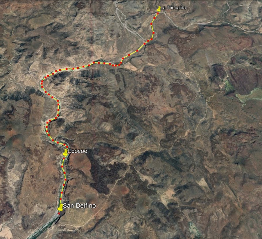
where is San delfino coming from?
Harald Pietschmann
|
|
|
David K
Honored Nomad
Posts: 64521
Registered: 8-30-2002
Location: San Diego County
Member Is Offline
Mood: Have Baja Fever
|
|
https://vivabaja.com/atondo-kino/
|
|
|
Lance S.
Nomad
Posts: 163
Registered: 2-16-2021
Member Is Offline
|
|
Love this kind of stuff.
|
|
|
4x4abc
Ultra Nomad
Posts: 4196
Registered: 4-24-2009
Location: La Paz, BCS
Member Is Offline
Mood: happy - always
|
|
well, Michael Mathes himself states that una Legua - 1 league - is 4.2 km (2.635 mi)
however none of the distances in this report compute with that value
seems like Atondo used a different definition for his log
Harald Pietschmann
|
|
|
David K
Honored Nomad
Posts: 64521
Registered: 8-30-2002
Location: San Diego County
Member Is Offline
Mood: Have Baja Fever
|
|
Quote: Originally posted by 4x4abc  | well, Michael Mathes himself states that una Legua - 1 league - is 4.2 km (2.635 mi)
however none of the distances in this report compute with that value
seems like Atondo used a different definition for his log |
A true or original league was the distance Roman legions marched in one hour. Obviously not a precise measurement! In Spanish times, a distance
traveled in one hour.
Admiral Atondo and the 50 + members of this expedition were not traveling on cleared roads, so the distance covered was minimal per hour on most days.
My belief is that his leagues were hours of travel and not any kind of real distance unit.
This definition of a Mexican league by Wiki is pretty much spot on:
In the Mexican countryside the league is still commonly used in the original sense of the distance a person can walk in an hour. So a
league along a good road on level ground is longer than a league on a difficult path over rough ground..
|
|
|
4x4abc
Ultra Nomad
Posts: 4196
Registered: 4-24-2009
Location: La Paz, BCS
Member Is Offline
Mood: happy - always
|
|
the Ives map shows a location S. Nicolas S-E of Comondu
where is that mentioned and what is it?
Harald Pietschmann
|
|
|
David K
Honored Nomad
Posts: 64521
Registered: 8-30-2002
Location: San Diego County
Member Is Offline
Mood: Have Baja Fever
|
|
San Nicolas was a Native rancheria visited previously by Padre Kino on a earlier expedition. Admiral Atondo does not mention it in the diary that I
read.
Perhaps I can find when Kino named that Cochimí village and report on it for you, from Bolton's book on Kino's life?
[Edited on 4-4-2024 by David K]
|
|
|
4x4abc
Ultra Nomad
Posts: 4196
Registered: 4-24-2009
Location: La Paz, BCS
Member Is Offline
Mood: happy - always
|
|
please, David, do that.
would love to find out where that is.
Harald Pietschmann
|
|
|
4x4abc
Ultra Nomad
Posts: 4196
Registered: 4-24-2009
Location: La Paz, BCS
Member Is Offline
Mood: happy - always
|
|
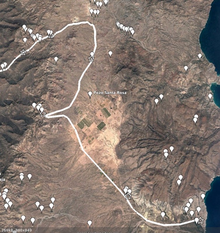
here we go
did "my own research"
Santa Maria is on the west side of the valley
one of the few places with abundant water
called Rancho Naocojoa - Nebocojol according to Atondo
none of the canyons on the east side have water
the next stopping point, San Gabriel, is a nameless Rancho with water
no other place on the way north to Bombedor has water
26°20'27.13"N, 111°34'32.27"W
Rancho Bombedor has ample water, but it wasn't a stopping point
the presence of date palms indicates later Jesuit use
the work camp at the foot of Cuesta Trabajosa is a Ranchito today
it is one of the easiest passes over Sierra La Giganta
it has a well established Camino Real section
all other camps fall into place.
a thought about Santa Maria
it could be that the group attempted to cross over Sierra La Giganta at that point
plus it has a lot of water
a number of Indian trails cross here and Camino Real is visible
however, with so many animals in the expedition it is a bit steep
Cuesta Trabajosa is a much simpler choice

here are the known water sources in the area
[Edited on 4-5-2024 by 4x4abc]
Harald Pietschmann
|
|
|
bajarickster
Junior Nomad
Posts: 33
Registered: 8-29-2007
Member Is Offline
|
|
Excellent Harald, thanks
|
|
|
David K
Honored Nomad
Posts: 64521
Registered: 8-30-2002
Location: San Diego County
Member Is Offline
Mood: Have Baja Fever
|
|
Harald, I love your route!
Mine was based on some assumptions made by Ives and Mathes.
Can you email me your Google Earth file for this? My interest in this was to help a friend who wants to retrace the route on horseback or muleback.
Thanks
Update: I have made an edit update on my page for the Dec. 15, Santa María location.
Your close up sat map is twisted off true north, so it was a bit of a chore to match on my sat image... but it looks like we are nearly using the same
arroyos... On this:
"the work camp at the foot of Cuesta Trabajosa is a Ranchito today
it is one of the easiest passes over Sierra La Giganta"
What is the GPS for that ranchito and Cuesta Trabajosa?
Thank you.
[Edited on 4-6-2024 by David K]
|
|
|
David K
Honored Nomad
Posts: 64521
Registered: 8-30-2002
Location: San Diego County
Member Is Offline
Mood: Have Baja Fever
|
|
San Nicolas location detailed
In December of 1683 (a year before the famous expedition to the Pacific) Kino was exploring:
3 leagues from San Bruno to San Isidro [Londó] + 3 more leagues to the village of San Pablo and they continued north (from San Isidro [Londó])
seeking an opening in the sierra (on the west).
In 'more than 6 leagues' they arrived at a 'new river' they named Santo Tomás (known to the Natives as Bunmedejol), now Bombedor. "A true California
stream, it sometimes flowed."
12 leagues that day.
The next morning, they turned west, "ascending always along the sands and bed of the river Santo Tomás." At noon, they took a siesta at a grove of
immense willows "and a most beautiful spring of very good water which flowed in in great abundance about a half league from the road."
They were on the right trail (so says Bolton), it led through the sierra going almost due west, and climbing a slope "which was not very bad," they
reached the summit where there was a dry arroyo running westward. It was the headwaters of the Arroyo Comondú [Viejo].
They traveled 6 leagues downstream. At dark, they came upon some fires. To not alarm the Natives, they turned back for half a league to camp, without
water.
The next day, they retraced their steps to meet the villagers and present them with gifts. Their chief was given the name 'Nicolas' by Padre Kino and
his village, San Nicolas. The place was near Arroyo Comondú [Viejo].
|
|
|
David K
Honored Nomad
Posts: 64521
Registered: 8-30-2002
Location: San Diego County
Member Is Offline
Mood: Have Baja Fever
|
|
Thanks to Harald (4x4abc), we now have a better route map for Dec. 15-19.
Their Santa María spring has now been correctly located, on the west side of the valley, which makes more sense.
The next night was at a place they named San Gabriel. Dr. Mathes believed that to be Rancho Santa Rosa. However, Harald places it further north, at La
Luz.
Finally, the revised route joins the envisioned one at Bombedor (they named San Marcos). Instead of heading west, Harald has the route go southwest to
the mountain where we both agree the expedition climbed up and over.
The maps, the distance, and comments now match the new data. See them at www.vivabaja.com/Atondo-Kino
|
|
|
4x4abc
Ultra Nomad
Posts: 4196
Registered: 4-24-2009
Location: La Paz, BCS
Member Is Offline
Mood: happy - always
|
|
it could not have been Santa Rosa as it has no surface water
it has a well - that means it has been dug later.
San Gabriel has a small surface spring
it is not named on the INEGI data
but it is still active and the water source is well maintained
the pre pavement road to Loreto goes right through it
Harald Pietschmann
|
|
|
David K
Honored Nomad
Posts: 64521
Registered: 8-30-2002
Location: San Diego County
Member Is Offline
Mood: Have Baja Fever
|
|
Route highlighted on 2009 Almanac
| Quote: Originally posted by 4x4abc | it could not have been Santa Rosa as it has no surface water
it has a well - that means it has been dug later.
San Gabriel has a small surface spring
it is not named on the INEGI data
but it is still active and the water source is well maintained
the pre pavement road to Loreto goes right through it |
Thank you, Harald!
On the following map, the route is highlighted and important points or camps circled and named here:
Expedition name (Native name) = Modern name:
Real de San Bruno (near gulf coast)
San Isidro = San Juan Bautista Londó
Santa María (Nebocojol) = Naocojoa
San Gabriel (Bunmedojol) = La Luz (on INEGI topo & Baja Almanac)
Santo Tomás (Cupemeyni) = Bombedor
Base of Mountain
Nuestra Señora de la O (Comondé) = La Presa
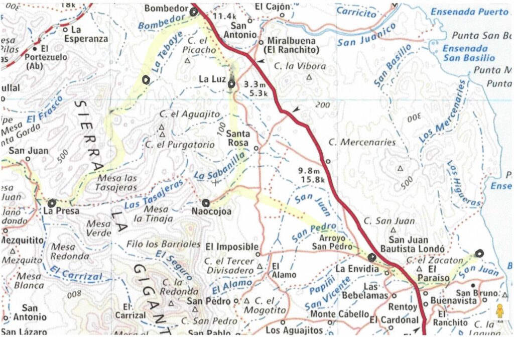
Interesting to see how a much more of a direct route to La Presa from Naocojoa was established (and shown above).
Perhaps when (or before) Visita Londó was attached to Mission Comondú (after it was founded in 1708) instead of Mission Loreto, which it was a part
of since 1699.
[Edited on 4-7-2024 by David K]
|
|
|
4x4abc
Ultra Nomad
Posts: 4196
Registered: 4-24-2009
Location: La Paz, BCS
Member Is Offline
Mood: happy - always
|
|
Mision Comondu was founded 1708
by then a more direct connection to Loreto was needed
the pass over Sierra La Giganta was at rancho El Cayuco
from Londo Rancho San Fransisco de Asis would likley be used
both using Cuesta San Francisco de Asis 26° 8'11.54"N, 111°34'49.22"W
over to Rancho Arroyo Hondo
then to San Nicolas
then Mision Comondu

[Edited on 4-7-2024 by 4x4abc]
Harald Pietschmann
|
|
|
David K
Honored Nomad
Posts: 64521
Registered: 8-30-2002
Location: San Diego County
Member Is Offline
Mood: Have Baja Fever
|
|
Not to go too far off topic, I only mentioned the short cut to Comondú Viejo/ La Presa from Naocojoa (and Londó), as it is shown as a trail on the
newer maps.
Harry Crosby shows the El Camino Real of 1708-1736 going north from the San Javier-San Miguel Camino Real... Once Comondú was moved south, then that
branch was not as important a road.
Map from 1994's 'Antigua California':

[Edited on 4-8-2024 by David K]
|
|
|
4x4abc
Ultra Nomad
Posts: 4196
Registered: 4-24-2009
Location: La Paz, BCS
Member Is Offline
Mood: happy - always
|
|
on one hand Crosby states that Camino Real is always a straight line and the he proposes a U-shape trail between Loreto and Comondu?
Harald Pietschmann
|
|
|
| Pages:
1
2 |


