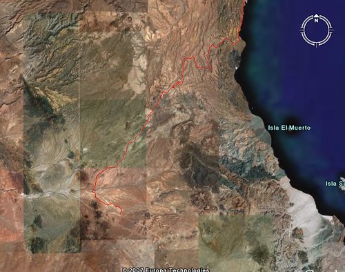
Using Google Earth I followed the dirt road from the LA Bay hwy across Luguna Agua Amarga, almanac pg 21, up to Mesa de Yubay and out the wash to
Bahia Guadalupe. I attemped this a few years ago but never made it to Mesa de Yubay.
TMW - 2-19-2007 at 11:57 AM
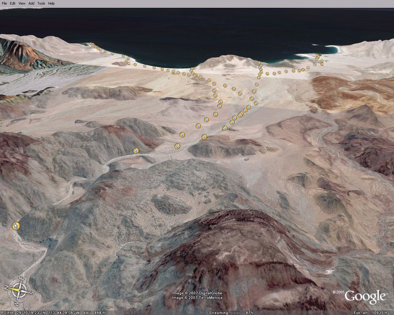
This is before the Mesa de Yubay wash after crossing the Laguna.
TMW - 2-19-2007 at 11:59 AM
In the top of the previous pix there is a dark rock. This is the rock where you join Mesh de Yubay. From here you follow the wash to the Sea of
Cortez.
TMW - 2-19-2007 at 12:01 PM
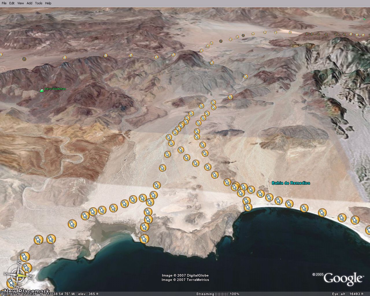
This pix is at Bahia Guadalupe. A few miles before here the road exits the wash on the north side.
TMW - 2-19-2007 at 12:14 PM
A closer view of the fish camp.
TMW - 2-19-2007 at 12:16 PM
Where the road leaves the wash.
bajalou - 2-19-2007 at 12:31 PM
Good work Tom - doing something useful on a long weekend at home
Tom-----Good show-----
Barry A. - 2-19-2007 at 01:34 PM
------the beach shown looks rocky, and my only visit there 23 years ago (or so) by tin-boat confirmed that it is indeed large cobble rock.
Do you know if there are any "sand" beaches on Bahia Guadalupe?
good work TW
John M - 2-19-2007 at 01:36 PM
Neal Johns and I plus a few others will be in this general area in two weeks - just looking for new and interesting places to have as a destination.
This just might do it.
I'm heading to google earth in a little while.
Neal - are you reading this?
John M
[Edited on 2-19-2007 by John M]TMW - 2-19-2007 at 02:10 PM
Barry I don't know about the sand beaches. I plan on going in there some time before summer. Maybe John and Neal can info us as to the conditions.
When I was looking at this on Google Earth I was trying to spot the helicopter that went down but the resolution is just not good enough unless maybe
your trained to do that kind of stuff.
Google Earth is really a neat program. Lou I spotted a wash where Matomi meets the hwy that runs southwest starting at 30-27-55x114-43-21 called El
Canelo, almanac pg 14. At 30-15-36x114-50-21 it passes very close to what looks like a mining dig at 30-15-10x114-50-25. From the mining dig there is
a road or series of roads that lead you back thru El Ronoso and Guayaquil to hwy1. Also west to San Juan de Dios. I was trying to find the Bill
Nichols trail which I assume starts near Playa la Costilla in the Los Heme wash. But I never could spot a trail.
Bill Nichols Trail
bajalou - 2-19-2007 at 05:25 PM
Here is the Bill Nichols trail on Google earth Tom.
I Emailed you a attachment of this so you can load it and zoom in
Need to do some more exploring of the El Canela area
don't know whats going on with the attachement - when you paste the http://farm etc above it takes you to the picture
[Edited on 2-20-2007 by bajalou]
Lou
Sharksbaja - 2-19-2007 at 05:36 PM
the image address needs to end with the file extension. bajalou - 2-19-2007 at 05:44 PM
Thanks Corky, I haven't had that trouble before but --bajalou - 2-19-2007 at 05:54 PM
I've looked at your waypoints Tom and looks very interesting - when do you want to try it? Of course GoogleEarth misses a few of the boulders in the
washes but what the hay
Coincidentally
Sharksbaja - 2-19-2007 at 06:59 PM
I am planning that trek myself. Should be a fun one you guys. Look at the pins I put in these photos. There is one track that leads down the arroyo to
the north from the top of the fan. There is another track that cuts over about halfway down the fan in case your using the southern approach or miss
the top cutoff.
Guadalupe bay
Bedman - 2-19-2007 at 08:05 PM
We had a very special invite from some friends Jan 2006. Destination Guadalupe bay from L.A. Bay. Heres a few pics, hope you like them.
[Edited on 2-20-2007 by Bedman]
on the trail
Bedman - 2-19-2007 at 08:12 PM
in the canyons
Bedman - 2-19-2007 at 08:51 PM
more canyons
Bedman - 2-19-2007 at 08:52 PM
Guadalupe
Bedman - 2-19-2007 at 09:05 PM
@!#%$%$&* .....sigh, I'll get it right this time!!
[Edited on 2-20-2007 by Bedman]
bay and point
Bedman - 2-19-2007 at 09:12 PM
shore and beach
Bedman - 2-19-2007 at 09:16 PM
Narrowing..
Bedman - 2-20-2007 at 01:38 AM
Soulpatch,
Yup, it narrows down quite a bit compared to the Dry lake and open alluvial plains that follow. Probably to 80 feet across (if memory serves me
right).
Have you been through the Canyon/Wash just North of La Gringa? That is one narrow, high canyon. 5 feet across and 70 feet high. The thing that most
impressed me was the geology of the canyons as you drive through. Rock formations change color from Green to Red to Tan to Slate blue to black to dark
brown. It's really a great drive. 4 Wheel wasn't really needed but was appreciated in the sandy washes. Baja Pinstriping will occur.
Bedman
TW & Bedman
John M - 2-20-2007 at 06:24 AM
TW - your route is inland from the coast, did Bedman indicate he went mostly near the coast?
Following TW's lead, I plotted a possible route. TW - or Bedman, would you comment on the route I've looked at and compare it to yours?
attached. John M
after I attached it, I realize how small it is. Maybe i can do better but it is 37kb already, maybe in two parts?? Later today.
[Edited on 2-20-2007 by John M]
TMW - 2-20-2007 at 09:16 AM
Thanks to all. Great stuff. Lou I'll may give it a try down that wash when I'm down for the race next month.TMW - 2-20-2007 at 09:21 AM
John It looks like the one I posted.Hook - 2-20-2007 at 11:15 AM
John M., Neal Johns, when are you guys going into this area? Could I tag along if the timing is right?ursidae69 - 2-20-2007 at 11:46 AM
bedman, nice images. I was with you guys on the trail that day I'm pretty sure. It was actually on Dec 30th. I was in the Red Tacoma. Here is a
picture.
Anyway, this is a great area and part of me is sad to see directions to it posted, such a beautiful area. I hope anyone that visits the area will
enjoy it as much as I did.
I will be back there again in a few more weeks....
[Edited on 2-20-2007 by ursidae69]TMW - 2-20-2007 at 03:46 PM
With satellite photos on Google Earth it's easy to find many areas that look like one could get there. It's another thing to actually make it
especially when the clean looking wash is filled with boulders. If it's difficult not many will go. Pole Line Road is one such place. This trip looks
simple on the map but when I tried it a couple of years ago we lost the road and then it became confusing so we turned around. Most people that go to
Baja stay on the paved road or very near it so personally I'm not too concerned with a lot of people getting to the remote areas. I'm more concerned
about people messing up cave paintings etc.ursidae69 - 2-20-2007 at 03:59 PM
I hear ya, I also would hate to see the cave paintings damaged. I'm surprised that the rock art near BoLA is in such good shape considering how
accessible it is.
That Google Earth is addicting. I have more and more places to check out in Baja now thanks to GE. Fun stuff. Bedman - 3-5-2007 at 01:18 AM
John and Ursidae69,
Sorry I haven't responded sooner. I must have lost the thread.
John, It was my first trip to Guadalupe. I'm pretty sure (95%) we came via the inland route.
Ursidae69, Yup, you were there. I got the pictures to prove it!!
(Unless, you weren't Supposed to be there, then "I know nothing, Pictures? What Pictures?"
BedmanDavid K - 3-5-2007 at 09:07 AM
On my GPS web page are the waypoints for this road and the one that continues on to the second dry lake and out to the coast in Arroyo los
Candeleros... Very cool area and colorful painted canyon!
Read about this region in Erle Stanley Gardner's 1961 'Hovering Over Baja'David K - 10-23-2010 at 03:03 PM
bump for JohnKen Cooke - 10-24-2010 at 08:55 AM
Quote:
Originally posted by David K
bump for John
I remember Marian Johns telling me about the Mesa de Yubay being a great place "to take the Jeeps" a few years ago. Thanks for bringing back this
great thread.David K - 10-24-2010 at 09:51 AM
There is tons of great reading on Nomad from the past... de nada Ken!