Just a news blip for those of you interested in a closer approach to Mission San Pedro Martir...
I just got a satellite phone call from TW, who in a Toyota truck just arrived at the visita ruins of San Isidoro, along the mission trail to San Pedro
Martir, from Santo Domingo.
TW (and other Nomads) has been exploring Baja the past few days, sending me Spot signals, and yesterday headed north from Hwy. 1 on the Los Martires
road (near El Arenoso) past the Sauzalito copper mines and north in the sierra foothills.
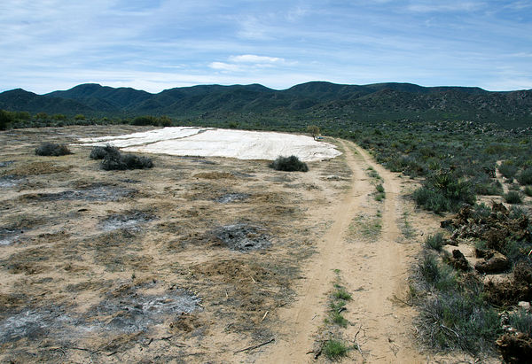
The new road that loops around the foothills passes within 3.1 miles of San Isidoro and a trail (looked like an auto road from space) goes to the
visita site. The road actually ends at the creek (Arroyo Campo del Oso on Almanac), across from the site. Walk across the creek and up onto the bench
to see the ruins. Tom took photos we will see when they get home.
Graham was at San Isidoro for several days during the 1997 El Niño rains trying to find the way to Mission San Pedro Martir (Journey with a Baja
Burro).
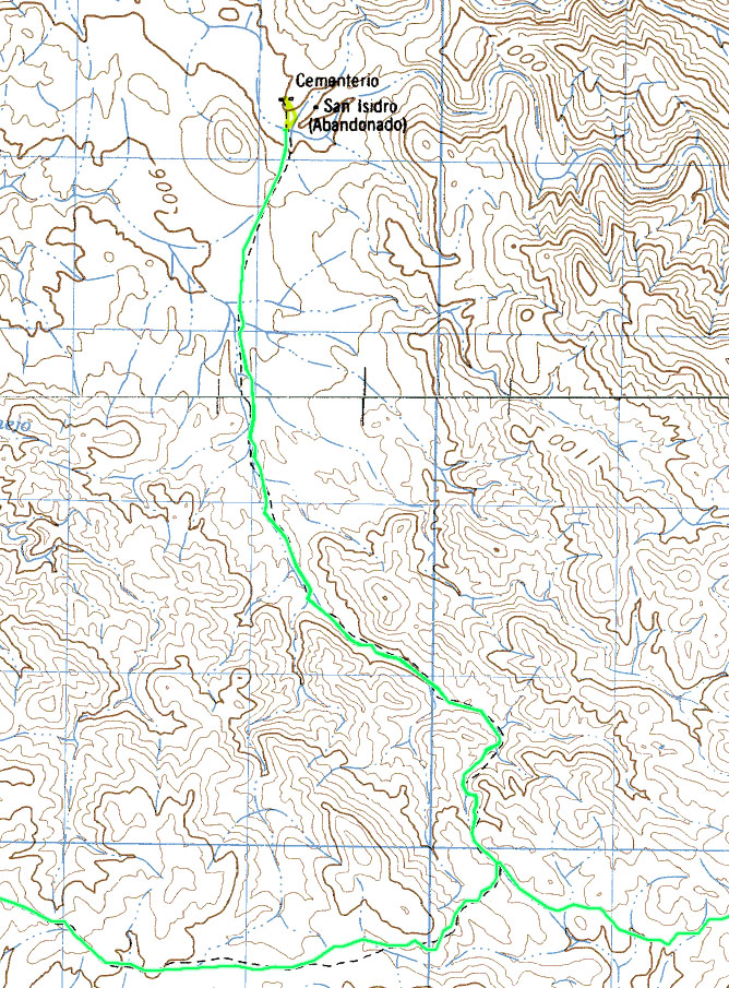
San Isidoro at end of blue arrow
Access road at end of red arrow... 3.1 miles from sierra loop road to San Isidoro . The ruins are straight across the creek and up on the bench from
the end of the road. New roads drawn in as solid lines.
[Edited on 1-22-2016 by David K]David K - 1-21-2016 at 06:42 PM
Yes Harald, you show the 3.1 mile road perfectly! TW sent me Spot signals from both ends today. He and the gang are back on Hwy. 1, north of San
Quintin as of their last Spot, before dark.Ken Cooke - 1-21-2016 at 07:46 PM
That sounds like a fun adventure! I hope TW took some photos.David K - 1-21-2016 at 08:23 PM
Yes, he called on his sat phone and told me he's taking photos of the ruins. Did you look at the 2005 photos there?Ken Cooke - 1-23-2016 at 09:15 AM
Yes, he called on his sat phone and told me he's taking photos of the ruins. Did you look at the 2005 photos there?
Yes, I reviewed the photos a couple of times. Thanks!TMW - 1-23-2016 at 09:20 AM
I got home Friday evening. It was an interesting trip for sure. I'll do a complete trip report in the next few days.
Rancho Santa Barbara is abandoned but there is a new ranch near by called Rancho Crestones where we met the wife. She said her husband had a bulldozer
and with the help from Rancho Ilusion, who also has a dozer, they cleared the road in. Rancho San Miguel is also abandoned.
Going in to the mission from the B1K course Roy had cooling problems with his Range Rover. It became a real serious concern for the rest of the trip.
It had me worried on how to get him out if it quit.
The road in is a narrow dirt/rock trail that would not require a 4x4 except at the end it is soft course sand near the creek where you have to turn
around. It was 3.3 miles distance on my truck from the B1K course to the creek. There was a camp setup probably for either the cowboys or the men
cutting cactus logs that we met on our way out.
Here are a few pictures from the mission site. There were two main buildings maybe 12x20 feet, just my guess. Also a smaller building maybe half the
size a short distance away.
The two main buildings.
The smaller building, maybe for storage?
This log tag was attached to a tree maybe a 100 feet away. bajatrailrider - 1-23-2016 at 09:35 AM
Thank you TMW.I hope to do this on my dirt bike,soon.Where you able to drive up to Mission.Or hike,or could dirt bike ride up to it?TMW - 1-23-2016 at 09:46 AM
It would be difficult to ride up. But the mission is only a couple of hundred yards from the creek, if that far. You just can't see it from the creek
because of the bushes etc. From the mission I could see my truck. TMW - 1-23-2016 at 09:49 AM
There is a barbwire fence between the creek and the mission, near the creek. It's kind of loose so it's easy to slip thru even for a fat guy like me.David K - 1-23-2016 at 09:54 AM
Thank you Tom, can you email me the fifth photo? Maybe I can put it in the new book?
For clarity, San Isidoro was a mission visita (visiting station) for Mission San Pedro Martir founded in 1794. Junipero Serra passed by this spot on
his way to San Diego in 1769.bajatrailrider - 1-31-2016 at 01:44 PM
Tom did you check out Rancho Nuevo York.Heard from friend abandon. I think the hard part for us,is only From V.G side finding the road,that starts to
N.Y.As other trips there years ago,went every way. Except where we wanted to go. David K - 1-31-2016 at 01:50 PM
Larry, in Tom's trip report I asked about Nueva York and it seems the road they used out to km 187 passed a few miles south of Nueva York.bajatrailrider - 1-31-2016 at 05:20 PM
Larry, in Tom's trip report I asked about Nueva York and it seems the road they used out to km 187 passed a few miles south of Nueva York.
Ok thanks David,I just wondered,if they checked it out. Today big storm here,We
need the water.TMW - 1-31-2016 at 08:04 PM
No we did not go to Nueva York due to the car problems Roy was having. We got to the junction for the turnoff and almost went that way since there was
a lot of fresh tire tracks that way. But I trusted my NUVI gps and turned left.
Below are Google Earth images of the turn off to NY and the site I think is it. The coordinates from GE are pretty close to those in the almanac. From
GE 30-44.210x115-46.375
bajatrailrider - 2-1-2016 at 09:22 AM
Thank Chuck.The yellow marker,then the round corral.The white object(If that is ranch house) looks like we been there.Then dirt road behind it.Did go
back the road back out to V.G.The road it the time,around N.Y. Was Moto only,big wash outs.That our Motos just barley made it past.Many goats in
corral there, trucks parked there.That was over ten years ago. I was just wondering,if it maybe better for us.To go up V.G wash to base of
mountains,then go.RT(south)we saw well used dirt road.Thinking it would bypass,all the other dirt roads.From Hiway 1.Get to the same place.bajatrailrider - 2-13-2016 at 08:21 PM
Thank you guys we did the ride today 126 mile round trip.Three dirt bikes.It was a long haul,about 6 riding hours.No flats/crashes good day.David K - 2-14-2016 at 08:42 AM
Thank you guys we did the ride today 126 mile round trip.Three dirt bikes.It was a long haul,about 6 riding hours.No flats/crashes good day.
What did you see? San Isidoro or all the way down to Los Martires jcn with Hwy. 1?bajatrailrider - 2-15-2016 at 09:22 PM
Hi David.We started from friends house.V Guerrero.Went up the sand wash at bridge.We got lucky never made wrong turn.We did pass turn off to
Isidoro.We did not stop.as this was our trial run.We did get to my Friends two ranchos.The we returned to San Quintin.The beach back to V.Guerrero.We
will plan next ride to Isidoro,from San Quintin.Then go back the way we came.Shorter ride that way.We also saw in 4x4s Cesar.Who said his Dad made the
new road to Isidoro.That is a long/hard haul on dirt bike. David K - 2-15-2016 at 10:38 PM
Thanks Larry. Have fun with Ed and Mike!bajatrailrider - 2-16-2016 at 10:50 PM
Mike is here now riding,We ride tomorrow to Coyotes to Meet Ed and his group. We found brand new,abandoned route.From San Vicente,all the way off road
to coyotes.On East side HWY 1,we have only been looking for this route 20 or more years.It could be done with 4x4.David K - 2-17-2016 at 09:00 AM
Sounds Great, Ed will likely have a nice ride from Santa Veronica to El Coyote today! You do the same from San Vicente to El Coyote!bajatrailrider - 2-18-2016 at 07:18 PM
Ok David Ed and his friend never made it.Eds friend on his KTM (I think) broke the rear wheel hub near Valley T.The are fine in Hotel,Ed will ride
back get his truck. Lucky no body hurt.All-good .Our group of 5 had great time exploring my new area.I cant find any of it on maps.Even my old
Maps.This new area,looks like hardly anybody there. David K - 2-18-2016 at 09:56 PM
Bummer!geoffff - 3-30-2016 at 11:28 PM
I was just out there a few weeks ago.
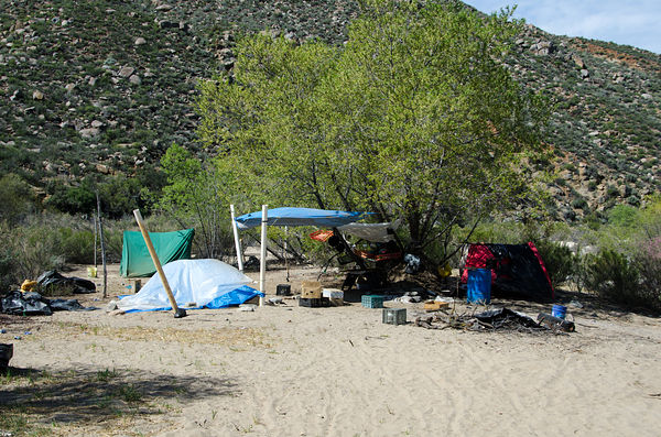
While I didn't see any people (it was Saturday), I saw plenty evidenceo of some kind of farming operation starting up at this visita site. I saw
various shacks & encampments, and a section of ground recently cleared of vegetation:
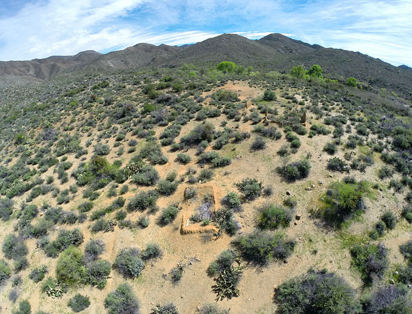
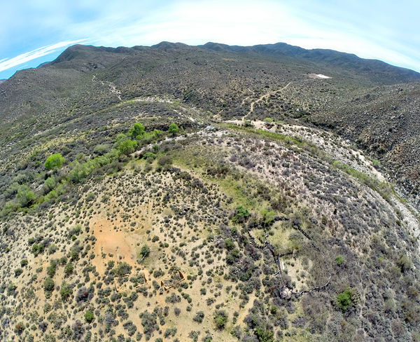
Here's what the site looks like from the air (drone):
I also just wrote about this in my trip report here: 10 Days in Baja
-- Geoff bajatrailrider - 4-5-2016 at 04:17 PM
We are planning to go back to see San Isidoro. We did not have time to take side road to see it last time. We will again be on dirt bikes,how much
time.To get to San Isidoro,off main dirt road?geoffff - 4-5-2016 at 04:31 PM
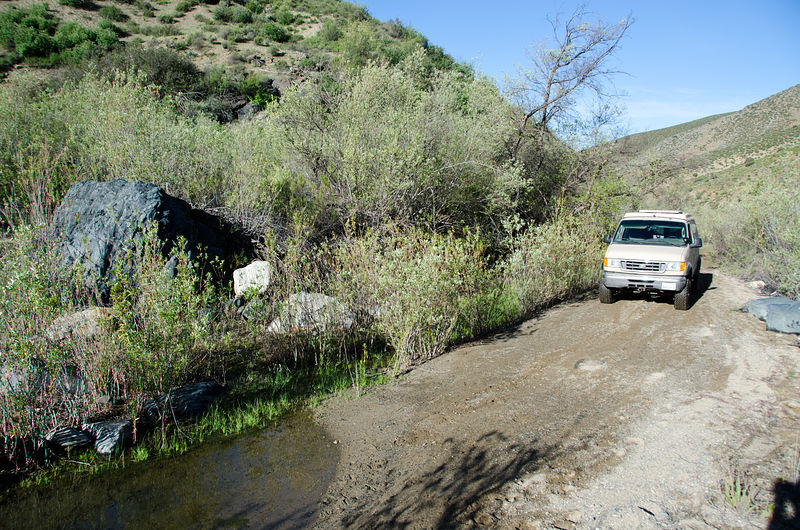
It's a 3.2 mile well-used dirt track. The first bit is in a tight little arroyo, and so is a bit bumpy and wiggly. Then it flattens out.
It took me 25 minutes creeping along in my van with stiff suspension, but I presume dirt bikes would be much faster.
-- Geoff bajatrailrider - 4-6-2016 at 05:22 PM
Thank you will report if we get chance next week. Im Friends with both ranchos,at south end of ride. Instead of carry so much extra gas on bikes.I
will call them to have some gas for us. geoffff - 4-6-2016 at 08:34 PM
Also, it might be worth walking around the site a bit more than I did. I somewhat regret not doing more exploring on foot while I was there!
The INEGI topo map indicates there should be a cementerio on the west side -- where I explored the old adobe walls. I did not find this.
And the map shows another dot (marked "San Isidro" [sic]) to the east of where I investigated, between the two river river tributaries -- it might be
interesting to see what's there.
-- Geoff
[Edited on 4-7-2016 by geoffff]bajatrailrider - 4-7-2016 at 07:55 AM
Time permitting we do carry hiking boots.Will try to hike and explore. Did you do this run North to south to SQ. Just wondering because,the road we
took after passing San Isidro.Tight canyon many low tree branches. Wondering how your Van passed the low branches. Your 4x4 Van way cool years ago.I
had Chev 1 ton 4x4 Van lifted big tires.They do good off road,but backing up is a chore.When needing 4x4 to get out of tight spot. geoffff - 4-7-2016 at 09:14 AM
I drove the loop "clockwise", east from SQ to San Isidoro, then south and finally back west out to Highway 1.
It was a bit overgrown and scratchy in a couple locations in washes -- enough to knock my mirrors flat back against the van body. My van's paint lost
its mirror finish a decade ago, so I don't worry about more scratches.
There was some minor vegetation around the road 16 miles west of the San Isidoro turn-off where the road follows a wash approaching Nueva York.
[gps:30.7102,-115.7196]
And then also 6 miles southeast of the San Isidoro turn-off where the road follows a tributary wash of the San Pablo. [gps:30.6839,-115.4589]
[Edited on 4-7-2016 by geoffff]bajatrailrider - 4-7-2016 at 05:17 PM
Thanks for pictures,that last part tight spots.Was the Dam to your Rt still full off water.geoffff - 4-7-2016 at 05:41 PM
Thanks for pictures,that last part tight spots.Was the Dam to your Rt still full off water.
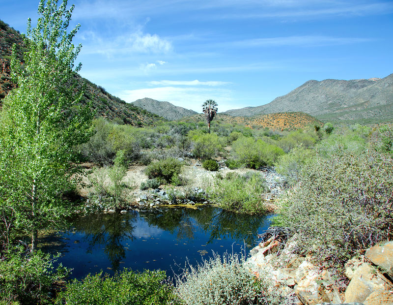
At San Pablo, with the last photo above? Yes -- there was pooled water there. I didn't consider about whether there was a dam, but I guess there must
have been. Here is a photo of the water there:
David K - 4-7-2016 at 06:16 PM
Great stuff Geoffff! bajatrailrider - 4-8-2016 at 09:38 AM
Yes that's the place we had lunch.Did you see any broke down 4x4 trucks/tractor.We saw 3 - 4x4s/one tractor.We talked to Cesar (who said his Dad,built
road to S.I) He said they where his. It rained here all night,still raining this morning.Should make great off road next week.