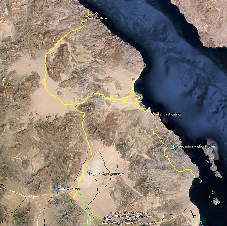
BajaNomad

La Gringa and the El Toro Copper Mine, Baja Bound article

David K - 4-27-2016 at 08:05 AM

The new Baja Bound newsletter was just published...

Here is one of the articles: https://www.bajabound.com/bajaadventures/bajatravel/la_gring...

This is a satellite image at the copper mine and ghost town ruins on El Toro mountain a mile east from the end of the road north of La Gringa:


Udo - 4-27-2016 at 08:21 AM

Thanks for providing the reference post.

David K - 4-27-2016 at 08:27 AM

I think it was the trip in April 2004 that several of us tried to find the ghost town of El Toro. Doc at Camp Gecko told us about it but about halfway there, the trail vanished on a small mesa and we didn't know which direction to go... Now, with Google Earth, we can see it was to stay to the left on the mesa.

Baja is such a great place to explore and see the past!

4x4abc - 4-27-2016 at 11:01 AM

got a lat/long for that image, David?

never mind, David, found it in the article

2 different mines? 2 different times/companies?

[Edited on 4-27-2016 by 4x4abc]

bacquito - 4-27-2016 at 11:18 AM

Thanks, interesting

4x4abc - 4-27-2016 at 11:54 AM

I have not known about the ghost town site
but I have driven the north trail to Ensenada Alcatraz (pretty wild!)


David K - 4-27-2016 at 11:57 AM

I would say its all part of the same operation. The wagon road, now 4x4 road ends at one mine and the foot/burro trail goes 1 mile to the other mine and townsite. I could not see any wagon road to or from the town using a different route.

willardguy - 4-27-2016 at 12:06 PM

Quote: Originally posted by 4x4abc  
I have not known about the ghost town site
but I have driven the north trail to Ensenada Alcatraz (pretty wild!)


whats out there and whats the difficulty level?

4x4abc - 4-27-2016 at 02:57 PM

Quote: Originally posted by willardguy  
Quote: Originally posted by 4x4abc  
I have not known about the ghost town site
but I have driven the north trail to Ensenada Alcatraz (pretty wild!)


whats out there and whats the difficulty level?


trail is hard to see (easier to spot on GE), very rocky, long stretches you have to imagine your trail. Best for MC. You can loop to the dry lake bed.

willardguy - 4-27-2016 at 07:16 PM

Quote: Originally posted by 4x4abc  
Quote: Originally posted by willardguy  
Quote: Originally posted by 4x4abc  
I have not known about the ghost town site
but I have driven the north trail to Ensenada Alcatraz (pretty wild!)


whats out there and whats the difficulty level?


trail is hard to see (easier to spot on GE), very rocky, long stretches you have to imagine your trail. Best for MC. You can loop to the dry lake bed.


I don't understand the broken yellow lines...is ensenada alcatraz not make-able from the copper mine and you have to go in a different way?

4x4abc - 4-27-2016 at 08:37 PM

the yellow line represents a visible trail
if there is no yellow line (mainly in Arroyos), you will have to create your own new trail
but it is drivable from the mine to the beach

willardguy - 4-27-2016 at 08:48 PM

Quote: Originally posted by 4x4abc  
the yellow line represents a visible trail
if there is no yellow line (mainly in Arroyos), you will have to create your own new trail
but it is drivable from the mine to the beach


thanks harald...is that the only way to ensenada alcatraz or is there an easier way?

4x4abc - 4-28-2016 at 08:55 AM

Quote: Originally posted by willardguy  


thanks harald...is that the only way to ensenada alcatraz or is there an easier way?


easy way to Bahia Alcatraz (beautiful beach!) is through Valle Agua Amarga
and check out the drive to Bahia Candelero (rocky beach)


Barry A. - 4-28-2016 at 09:17 AM

This is fantastic information----------I have been to Bahia Alcatraz many times by boat back in the '70's and early '80's, and landed there to explore the beach. It truly is a beautiful and remote beach and bay. I had no idea it could be accessed by 4x4's.

Many thanks for this insight.

David K - 4-28-2016 at 09:39 AM

BajaNomad and family camp there. The road to Bahia Guadalupe/Remedios has been off maps forever... I checked it out in 2001/2002.

Barry A. - 4-28-2016 at 11:10 AM

Quote: Originally posted by David K  
BajaNomad and family camp there. The road to Bahia Guadalupe/Remedios has been off maps forever... I checked it out in 2001/2002.


True, David. We did see several old vehicle tracks on the rough cobble beaches of Bahia Guadalupe (Pescadores) and the sandy wash (Mesa de Yubay) that feeds into the Sea there, back in the '70's/'80's, but never any veh. tracks at Ensenada Alcatraz. Harald's revelation that Alcatraz was also accessible by vehicle really caught me by surprise. I have spent a lot of time walking Alcatraz as it was so pristine and beautiful---much nicer and cleaner than the cobble beaches at Pescadores (see Almanac map) back then, as I remember.

bkbend - 4-28-2016 at 11:23 AM

Here is a view on the hike into El Toro and some of the 'structures' and kitchen facilities.


toro 4.jpg - 187kBtoro 1.jpg - 174kBtoro 2.jpg - 191kBtoro  3.jpg - 171kB

Fernweh - 4-28-2016 at 11:34 AM

Thank you for the great pictures.

The kitchen looks like the one, we had our last Christmas dinner one.....here in El Centenario.

Karl

Maron - 4-28-2016 at 02:15 PM

Super info and pictures. Thanks for the info.

David K - 4-28-2016 at 03:28 PM

Thank you BK! That's the first ground level photos I have seen of the ruins.. any more?

David K - 4-28-2016 at 03:49 PM

Quote: Originally posted by Barry A.  
Quote: Originally posted by David K  
BajaNomad and family camp there. The road to Bahia Guadalupe/Remedios has been off maps forever... I checked it out in 2001/2002.


True, David. We did see several old vehicle tracks on the rough cobble beaches of Bahia Guadalupe (Pescadores) and the sandy wash (Mesa de Yubay) that feeds into the Sea there, back in the '70's/'80's, but never any veh. tracks at Ensenada Alcatraz. Harald's revelation that Alcatraz was also accessible by vehicle really caught me by surprise. I have spent a lot of time walking Alcatraz as it was so pristine and beautiful---much nicer and cleaner than the cobble beaches at Pescadores (see Almanac map) back then, as I remember.


Erle Stanley Gardner's map from his 1961 'Hovering Over Baja'


The 2009 Almanac with the roads north of L.A. Bay penciled in.


AAA Map with new roads penciled-in. Note, mileages on the roads north of L.A. Bay.

4x4abc - 4-28-2016 at 06:42 PM

Quote: Originally posted by Barry A.  
Quote: Originally posted by David K  
BajaNomad and family camp there. The road to Bahia Guadalupe/Remedios has been off maps forever... I checked it out in 2001/2002.


True, David. We did see several old vehicle tracks on the rough cobble beaches of Bahia Guadalupe (Pescadores) and the sandy wash (Mesa de Yubay) that feeds into the Sea there, back in the '70's/'80's, but never any veh. tracks at Ensenada Alcatraz. Harald's revelation that Alcatraz was also accessible by vehicle really caught me by surprise. I have spent a lot of time walking Alcatraz as it was so pristine and beautiful---much nicer and cleaner than the cobble beaches at Pescadores (see Almanac map) back then, as I remember.


it get's better - the small estero on the north/south beach part of Alcatraz has remnants of a pier. Maybe at times the El Toro ore was shipped from there. That would explain the trail going north.


bkbend - 4-29-2016 at 10:03 AM

I'd heard they shipped from a pier along that stretch of coast but never thought of looking at GE for it. Good catch! I trolled once inshore along that stretch from Alcatraz to La Gringa and looked for signs but couldn't see anything. It may have been high tide and all we could see was another rock pile to snag a lure on. I do remember the estero and large gravel bar fronting it, so it shouldn't be too hard to find. Unfortunately the fishing wasn't spectacular so it's not a place I routinely go to.

David K - 4-29-2016 at 11:21 AM

Is there any piles of copper ore by the beach there, as there is (was) at La Gringa?

How was ore transported, by burro? They built a wagon road to La Gringa in advance of the proposed aerial tramway.

I am going to guess La Gringa was a far superior port, as any wind just churns up the Sea of Cortez making open landing near impossible. La Gringa remains calm and protected.

Great new Baja mysteries!!

bkbend - 4-29-2016 at 05:25 PM

Disregard what I was saying above. I finally looked at GE the the pier shown is not the same estero I was thinking of. I remembered seeing one almost due east of the mine area and thought it was the one 4x4 was showing. I found the estero above on GE and I've also been right by it in a boat and didn't see anything. I need to be more observant. Maybe a trip is in order next winter.

4x4abc - 4-29-2016 at 05:50 PM

David,

what else is in that Gardner book you mentioned above?
(Erle Stanley Gardner's map from his 1961 'Hovering Over Baja')

David K - 4-30-2016 at 09:40 AM

Quote: Originally posted by 4x4abc  
David,

what else is in that Gardner book you mentioned above?
(Erle Stanley Gardner's map from his 1961 'Hovering Over Baja')


It's about getting into the palm canyons north of L.A. Bay, mainly Salsipuedes (which means get OUT if you can... to Gardner, it meant get IN if you can).

They tried by land and by sea...


But, it was by AIR that proved to be the best way!


[Edited on 4-30-2016 by David K]

4x4abc - 4-30-2016 at 11:22 AM

I will check Karl's collection

David K - 4-30-2016 at 12:57 PM

Please read as much as you can to find all sorts of gems in those books!

David K - 4-30-2016 at 01:39 PM

If you search for posts by larryC, you will see where he found that cliff where the Gardner team lowered their Pak-Jaks down into the canyon by rope.

EDIT: Found it... lot's of great photos!: http://forums.bajanomad.com/viewthread.php?tid=33067

[Edited on 4-30-2016 by David K]