BajaNomad

DeLorme InReach Communication System

TMW - 1-2-2017 at 12:01 PM

Some Observations from tracking an InReach system.

Their topo map is crap. Wrong names of places and roads that don't exist.

Their road map is almost useless.

The aerial map is good since it's google earth or a similar satellite map.

It can also be noted that the map on Spot is no better.

The only good map on either is the satellite view. The Spot satellite map does show the highways and major towns.

The best thing about InReach is the texting communication, that is a big plus. The tracking system is good too.

[Edited on 1-2-2017 by TMW]

monoloco - 1-2-2017 at 12:27 PM

The InReach is popular with the commercial fishing fleet in Alaska. It's nice that you can tether it to your smart phone.

4x4abc - 1-2-2017 at 12:53 PM

I have the DeLorme
better options than SPOT, but still a lousy product
my hope is, that it gets better now that Garmin owns DeLorme


monoloco - 1-2-2017 at 01:11 PM

Quote: Originally posted by 4x4abc  
I have the DeLorme
better options than SPOT, but still a lousy product
my hope is, that it gets better now that Garmin owns DeLorme

Their user interface sucks, that's why it's nice to be able pair it with a smart phone.

4x4abc - 1-2-2017 at 04:28 PM

Quote: Originally posted by monoloco  
Quote: Originally posted by 4x4abc  
I have the DeLorme
better options than SPOT, but still a lousy product
my hope is, that it gets better now that Garmin owns DeLorme

Their user interface sucks, that's why it's nice to be able pair it with a smart phone.


3 out of 4 times the pairing fails

ehall - 1-2-2017 at 05:21 PM

I've had a lot of trouble with the pairing also. Delorme isn't perfect but it's probably the best thing for now.

TedZark - 1-2-2017 at 06:21 PM

I ride motorbike alone most of the time on back roads. I have thought about that product... just in case. Is it worth the cost and the subscription?

ehall - 1-2-2017 at 07:14 PM

Quote: Originally posted by TedZark  
I ride motorbike alone most of the time on back roads. I have thought about that product... just in case. Is it worth the cost and the subscription?


Gives the wife piece of mind when I am riding in baja. That's worth a lot.

JZ - 1-2-2017 at 07:32 PM

For maps you want to use MotionX. Run it on your phone or tablet. It is money.

Stand alone GPS and devices are 10 years ago.


[Edited on 1-3-2017 by JZ]

DavidT - 1-2-2017 at 07:34 PM

Back in my day...
:biggrin:

TMW - 1-2-2017 at 08:31 PM

Quote: Originally posted by JZ  
For maps you want to use MotionX. Run it on your phone or tablet. It is money.

Stand alone GPS and devices are 10 years ago.


[Edited on 1-3-2017 by JZ]


What is so great about MotionX?

On their web site their map is not up to date.

[Edited on 1-3-2017 by TMW]

4x4abc - 1-2-2017 at 09:17 PM

Quote: Originally posted by TedZark  
I ride motorbike alone most of the time on back roads. I have thought about that product... just in case. Is it worth the cost and the subscription?


Since SPOT and DeLorme are the only two (consumer) options, they are worth their money.
But both are still lousy products.

On the good side - the SOS seems to work on both without fail.

Other than that?
Imagine an emergency.
It's night. It's raining, You are bleeding (not enough for SOS). You lost your glasses. Now imagine fiddling with the tiny keys to send a help request to a friend. Right.

These products were developed by geeks in Boston at a well lit desk. Brilliant idea. Lousy execution.

bajaguy - 1-2-2017 at 09:27 PM

If you know your equipment, finding the right button isn't a problem. Waiting until there is a problem to determine where or which button to use is operator failure

My SPOT 3 does what it is designed to do, and I can find the "Help" and "911" buttons just fine

Quote: Originally posted by 4x4abc  
Quote: Originally posted by TedZark  
I ride motorbike alone most of the time on back roads. I have thought about that product... just in case. Is it worth the cost and the subscription?


Since SPOT and DeLorme are the only two (consumer) options, they are worth their money.
But both are still lousy products.

On the good side - the SOS seems to work on both without fail.

Other than that?
Imagine an emergency.
It's night. It's raining, You are bleeding (not enough for SOS). You lost your glasses. Now imagine fiddling with the tiny keys to send a help request to a friend. Right.

These products were developed by geeks in Boston at a well lit desk. Brilliant idea. Lousy execution.

JZ - 1-3-2017 at 12:14 AM

Quote: Originally posted by TMW  
Quote: Originally posted by JZ  
For maps you want to use MotionX. Run it on your phone or tablet. It is money.

Stand alone GPS and devices are 10 years ago.


[Edited on 1-3-2017 by JZ]


What is so great about MotionX?

On their web site their map is not up to date.

[Edited on 1-3-2017 by TMW]


Ok, don't take good advice when you get it.


ljprusko - 1-3-2017 at 04:12 AM

Everyone has a different budget and different GPS needs. I keep a boat in Rocky Point and go off offshore 50 miles for 2-3 days at a time, ride down Baja a couple times a year on my motorbike, and do occasional shorter motorbike trips into Baja or the mainland. I've been using Delorme for the past 3 years as an emergency contact device and to keep in contact with others to let them know everything is OK. It's paired with my iPhone every time, worked perfect every time, it allows me to text back and forth with people who have US or Mexico cell phones. And what I like about it is I just put their US or Mexico phone numbers in my contacts, and it automatically figures out the country code and how to contact them. Costed about $200 up front, and my monthly plan is $13, which allows for unlimited 3 preset messages (ex: everything is OK), and ten free texts a month. If I go a little over my data plan its not that expensive either. Various plans to chose from based on your needs. And when I text someone, I have it set up to automatically give them my current GPS coordiantes or they can log onto the Delorme website and see exactly where I'm at on a map in case of an emergency. Affordable and suits all my GPS needs, have nothing but positive things to say about it.

ehall - 1-3-2017 at 05:10 AM

Quote: Originally posted by ljprusko  
Everyone has a different budget and different GPS needs. I keep a boat in Rocky Point and go off offshore 50 miles for 2-3 days at a time, ride down Baja a couple times a year on my motorbike, and do occasional shorter motorbike trips into Baja or the mainland. I've been using Delorme for the past 3 years as an emergency contact device and to keep in contact with others to let them know everything is OK. It's paired with my iPhone every time, worked perfect every time, it allows me to text back and forth with people who have US or Mexico cell phones. And what I like about it is I just put their US or Mexico phone numbers in my contacts, and it automatically figures out the country code and how to contact them. Costed about $200 up front, and my monthly plan is $13, which allows for unlimited 3 preset messages (ex: everything is OK), and ten free texts a month. If I go a little over my data plan its not that expensive either. Various plans to chose from based on your needs. And when I text someone, I have it set up to automatically give them my current GPS coordiantes or they can log onto the Delorme website and see exactly where I'm at on a map in case of an emergency. Affordable and suits all my GPS needs, have nothing but positive things to say about it.


Maybe the iPhone pairs better? My Droid sure has trouble. I agree with your post. I used the unlimited plan at first but now that my phone works in alot more places I switched to the cheapest plan.

kevin_in_idaho - 1-3-2017 at 05:26 AM

I keep wondering when there will be an updated version of the inReach as it's quite outdated? I would think that Garmin is/would be working on this as it wouldn't take much to make it a bit more "modern".

AguaDulce - 1-3-2017 at 06:38 AM

I have the In Reach. it is not instant when you text. You have to be outside and "wait" for the satellite to find you. I use it to let my family know I am OK. They like the map showing where I am. Is the SOS instant? I dont know and dont want to find out.

4x4abc - 1-3-2017 at 10:52 AM

Quote: Originally posted by AguaDulce  
I have the In Reach. it is not instant when you text. You have to be outside and "wait" for the satellite to find you. I use it to let my family know I am OK. They like the map showing where I am. Is the SOS instant? I dont know and dont want to find out.


the SOS is as "instant" as your messages
depending on satellite coverage it might be up to 20 minutes delay

TMW - 1-3-2017 at 10:58 AM

It depends on what you mean by instant. Instant help only happens on TV not in the real world.

Any SOS signal requires someone to channel it to an emergency center or if it's automatically sent to an emergency center someone in the emergency center will need to determine who to contact to get help to you. If you are in the middle of nowhere it could be hours if not days for help to arrive.

4x4abc - 1-3-2017 at 11:02 AM

Quote: Originally posted by kevin_in_idaho  
I keep wondering when there will be an updated version of the inReach as it's quite outdated? I would think that Garmin is/would be working on this as it wouldn't take much to make it a bit more "modern".


I am so hoping that Garmin will clean up that mess
one of the reason I bought the DeLorme in the first place - Garmin support

I began my GPS world with DeLorme 100 years ago
it was painful and frustrating


then I moved on to Garmin and have been very happy ever since
it was almost as good as moving from Windows to Mac

I have additionally used sat phones (with the same painful learning process of moving from bad to good) for almost 20 years. saved my ass a couple of times.

However, SPOT and InReach deliver something a sat phone can't - 24/7 SOS service. With pros knowing how to manage your emergency. It won't help you much if the only person you can reach on your sat phone is your mother in law in New York (or Munich for that matter), trying to tell her you need a helicopter to that one particular canyon in Baja.
"Baja?" she asked.

[Edited on 1-3-2017 by 4x4abc]

willardguy - 1-3-2017 at 11:16 AM

Quote: Originally posted by TMW  
It depends on what you mean by instant. Instant help only happens on TV not in the real world.

Any SOS signal requires someone to channel it to an emergency center or if it's automatically sent to an emergency center someone in the emergency center will need to determine who to contact to get help to you. If you are in the middle of nowhere it could be hours if not days for help to arrive.


so you could give the emergency center the contact information of a nomad (lets say someone thats always on) that could text you (assuming you have whichever unit has the text feature), post your location here and maybe the nearest nomad could help out?

4x4abc - 1-3-2017 at 11:30 AM

Quote: Originally posted by willardguy  


so you could give the emergency center the contact information of a nomad (lets say someone thats always on) that could text you (assuming you have whichever unit has the text feature), post your location here and maybe the nearest nomad could help out?


you might be on to something good.
Help from the knowledgeable Nomad community.
I like it!

TMW - 1-3-2017 at 12:09 PM

For Spot SOS you give them two peoples name and contact info in case more info is needed by the emergency center.

In case of help on Spot you list the people that will get the signal. For me there are a couple of people on my list and I've told my wife to contact them so they can coordinate any help effort.

[Edited on 1-3-2017 by TMW]

willardguy - 1-3-2017 at 12:33 PM

Quote: Originally posted by TMW  
For Spot SOS you give them two peoples name and contact info in case more info is needed by the emergency center.

In case of help on Spot you list the people that will get the signal. For me there are a couple of people on my list and I've told my wife to contact them so they can coordinate any help effort.

[Edited on 1-3-2017 by TMW]


so with SOS who typically would you choose to contact? (in baja)

TMW - 1-3-2017 at 12:59 PM

The contact info for SOS should be someone who knows your medical history for example. It's not for the extraction itself but in case the responders need further info maybe for medical issues.

mtgoat666 - 1-4-2017 at 11:12 AM

Garmin is rolling out several new models that combine the typical garmin hardware with irridium/inreach communication capability. Inreach se+ and explorer+

Should be available by march 2017

David K - 1-4-2017 at 11:52 AM

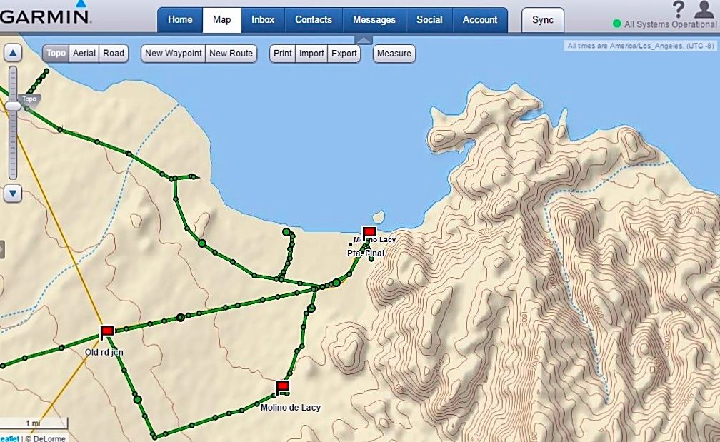
Tom, to me, the inReach topo maps are nice...
Punta Final area from my explorations last week:


My track (from the top down) is Campo Beluga, El Sacrificio, beach, Punta Final, Molino de Lacy, then from the old road jcn. out to Hwy. 5, south side of Arroyo Santa Maria bridge.

4x4abc - 1-4-2017 at 12:02 PM

the topo map image shows up where? On your phone? On your computer?
And the settings on your InReach were what?

David K - 1-4-2017 at 12:17 PM

Quote: Originally posted by 4x4abc  
the topo map image shows up where? On your phone? On your computer?
And the settings on your InReach were what?


On my computer, factory settings:
Send Interval: 10 min
Log Interval: 1 min
Extended Tracking: Off
Prompt for MapShare: On

JZ - 1-4-2017 at 03:39 PM

For maps. MotionX on your phone/tablet. Much better. I've had 3-4 Garmin GPSs and the user interface / screen on them is absolute garbage compared to the phone based apps.

Only value of the InReach is for the messaging, iyam.


[Edited on 1-4-2017 by JZ]

David K - 1-4-2017 at 04:15 PM

Yes, the two way texting feature is terrific. Sadly, there isn't an easy menu for who gets the texts or emails on how to see the track. It is new to me to use and this past week's trip was a learning one. I had no idea what my friends were seeing or why they couldn't follow me. I still need to look at the email alerts and how to click onto the moving track.

Edit: Some had a hard time knowing what to click, but others didn't. The emails do come from Garmin and go to your junk folder until you accept it as known.

[Edited on 1-4-2017 by David K]

PaulW - 1-5-2017 at 10:47 PM

inReach
2 days trying with android phone paired but no transfer of info
Da
The map I get in the states is outstanding. In Baja it is pretty simple and useless in most places I looked.

David K - 1-5-2017 at 11:15 PM

Quote: Originally posted by PaulW  
inReach
2 days trying with android phone paired but no transfer of info
Da
The map I get in the states is outstanding. In Baja it is pretty simple and useless in most places I looked.


I paired by phone with it, but it was not consistently paired and went through the steps to re-pair the two many times. For most of the trip, the phone provided a live map of great detail with my speed and heading shown... The map online (when I got home) only has points every minute recorded with straight lines between (which wasn't bad), but oddly, the last two days it had points every 10 minutes (and that is not a good map of the roads taken). Why did it change?

bryanmichaelmeyer - 1-26-2017 at 04:28 PM

inReach in my case has only been used as a check in off the grid and for swell and weather updates. pairing seemed to work for messages but was a waste of time. just bought a gps for actual mapping.

ehall - 1-26-2017 at 06:45 PM

The new update seems to have fixed the pairing problem with the droid.

David K - 1-27-2017 at 08:20 AM

Ed, can you advise me on how to transfer my trip route to Garmin BaseCamp and/or click on the GPX file?

This is what I see when on Map (explore.delorme.com/Map) I click Export (to make a file to send or to put the track on the BaseCamp map):


Adobe message.jpg - 191kB

ehall - 1-27-2017 at 09:38 AM

http://avoidingchores.com/how-to-export-the-track-log-from-y...


I have never tried it. Basecamp would probably want it in gpx format. Google earth in kml

ehall - 1-27-2017 at 09:54 AM

It works using gpsvisualizer to open it. Good video on the link that shows what to do.

ehall - 1-27-2017 at 10:00 AM

Import into my collections on basecamp. works fine.

David K - 1-27-2017 at 10:01 AM

Quote: Originally posted by ehall  
http://avoidingchores.com/how-to-export-the-track-log-from-y...


I have never tried it. Basecamp would probably want it in gpx format. Google earth in kml


Thanks Ed, 4x4abc had already sent me that YouTube, I followed it and when I click on to export the file, clicking on GPX (as it says to do), I get that Adobe pop up that I showed just above.

ehall - 1-27-2017 at 12:11 PM

Did you try to save it and not open it?

David K - 1-27-2017 at 12:40 PM

Well, when I put my mouse on it to do anything, and click, that Adobe message appears. Thanks for your assistance! Harald is also giving me ideas to try.

wessongroup - 1-27-2017 at 12:53 PM

Sure makes what Lewis and Clark, and others, did a lot more impressive ... and to think when young ... no phones and people was the big draw in Baja :):)

[Edited on 1-27-2017 by wessongroup]

David K - 1-27-2017 at 01:40 PM

Well, when I am exploring, it gives my wife and friends peace of mind seeing where I am and we can exchange texts.
The issue I am seeking help with is how to edit-correct the map track it creates online, that is all. The DeLorme inReach Explorer is a terrific tool to communicate to phones or emails and give you your location.

PaulW - 1-27-2017 at 03:21 PM

Quote: Originally posted by ehall  
It works using gpsvisualizer to open it. Good video on the link that shows what to do.

====
Use care when using gpsvisualzer with GPSBabel as the version they use is not complete. If up want to convert files go direct to GPBabel.org direct as it has all the features.

ztrab - 2-2-2017 at 12:03 AM

I was given a unit when they first came out to evaluate, before that I had a Spot but still had to carry a Sat phone in Baja to keep the Mrs. happy. The two way texting and confirmation that my sent msg is received eliminates the need/expense/bulk of a sat phone. When riding in a group, you can also communicate with other users. Really handy if you have to split the group up or some one gets separated. I had to use the sos stateside in a remote area after nearly severing a finger. I was was in really technical terrain, no cell and I figured I'd lose the finger (hand surgeon agreed) if I had tried to ride out. The extraction went pretty smooth thanks to the ability to communicate, it took several hours to get to me, I even got a nap in. Great little device. I carry it whenever I'm riding or traveling out of the country. I've used the weather service a few times, have used the mapping as I'm usually find with my Garmin Montana.

Cliffy - 2-2-2017 at 08:07 AM

I use it in the airplane as an easy one button push should I be going down over bad terrain (most of where I fly here in N AZ)and for family to track our progress in the airplane or the travel trailer. It also tracks altitude so they can see when I push the button that the altitude track was going down rapidly. Great for rescue in the trees or mountains. I too, think the interface is troublesome. The texting defies my comprehension. Like was said, designed by geeks at a desk as most electronic stuff is today. Including some of Garmin's
airplane stuff! Can see lots of needed improvements but it works for what we want right now.