BajaNomad

what i would like to see

4x4abc - 6-24-2019 at 05:44 PM

less than a handful of groups have followed (part) of the Camino Real

Edie Littlefield Sundby and Genevieve Mattar with Kevin Branscum have done it without helicopter support and TV money.
https://www.facebook.com/TheMissionWalker/
https://caminorealbaja.com/

if you have ever been on the Camino Real you understand what an incredible undertaking that was.

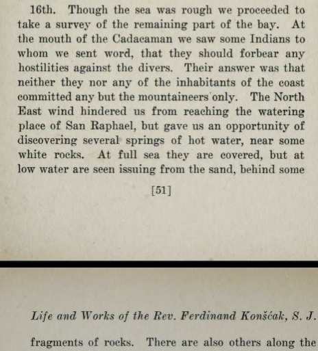
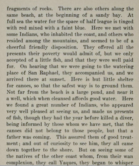
here is what I would like to see - someone retracing the route Padre Fernando Consag followed to travel along the coast from Santa Ana (north of Tres Virgines) to the Colorado River.

Here is his diary:
https://archive.org/stream/lifeworksofrever00kons#page/46/mo...


Consag.jpg - 179kB

David K - 6-24-2019 at 10:14 PM

Great idea. I did find on Google Earth the hot spring on the coast near Pancho's that Consag described in 1747. This was after I asked Pancho if he knew about it... he did. Told me it was about 2 kms. south of his place.

Your link didn't work for me tonight and one that I had for his book was also offline.
If you read Spanish, a fellow in Ensenada I chat with on Facebook wrote a book on Consag, and it is online: http://www.archivohistoricobcs.com.mx/files/libros/pdf/Texto...

4x4abc - 6-25-2019 at 06:55 AM

I have the hotspring location at 2 miles from Pancho's - which one is correct?

David K - 6-25-2019 at 07:29 AM

Show me yours! LOL
As I said 2 kms. is what Pancho told me.
It is closer to 2 miles, yes.

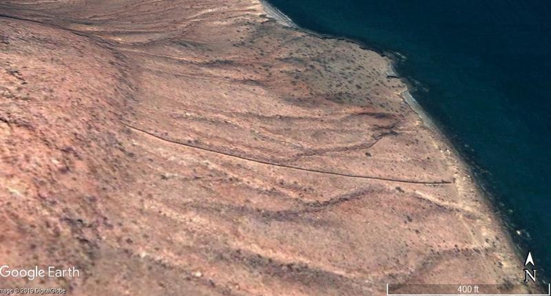
Now, this wall is pretty interesting, 4.5 miles south from Pancho's:


Bajazly - 6-25-2019 at 08:14 AM

The wall

IMG_6675.jpg - 178kB

The break in the wall just before it goes down the cliff.

IMG_6662.jpg - 190kB

David K - 6-25-2019 at 08:46 AM

Great pics! That wall is still pretty tall. Maybe it is a lot newer than the ones at Las Animas, which also don't seem to have any purpose or they just were never made that high?

Bajazly - 6-25-2019 at 09:19 AM

Pretty impressive how uniform the wall is in height and width.

IMG_6658.jpg - 234kB

The gate for whatever reason looks like it was built into the wall and not torn out later.


IMG_6651.jpg - 214kB

4x4abc - 6-25-2019 at 11:20 AM

I know the wall well

the hot spring location I have


Attachment: San Rafael hotspring.kmz (771B)
This file has been downloaded 243 times

Bajazly - 6-25-2019 at 11:45 AM

Looks like the only access would be by water. Have you ever been to the spring itself Harald? Does it run all year?

4x4abc - 6-25-2019 at 03:20 PM

haven't been to the spring yet

the Vallecito south of it is also on my list
lots of wildlife tracks (indicating water) are present
just south of the Vallecito is the wall
I am surprised though not to see any corrals in that area

4x4abc - 6-25-2019 at 03:31 PM

Vallecito

Vallecito.jpg - 220kB

sat images show 2 walls

2wall.jpg - 166kB

Bajazly - 6-25-2019 at 06:03 PM

What is a Vallecito? And you say two walls? Where is the second one?

4x4abc - 6-25-2019 at 11:38 PM

Valle = valley
Vallecito - little valley

here is the 2nd wall


2nd.jpg - 188kB

Bajazly - 6-26-2019 at 08:39 AM

Don't believe that is another wall. We walked right past it on the trail you can see and where as I don't remember exactly what it was, had it been a wall, we would have checked it out too. You land on the beach pretty much right below the lower arrow and have to ascend maybe a hundred or so feet to get to the trail so maybe we walked past it not noticing it. Time to go back and look again.

David K - 6-26-2019 at 09:09 AM

That could be just a shadow in a narrow gully?
No corrals as there is no rancho nearby?

Yes, that is where I also spotted the hot spring. It would be a short walk from the road and shorter if you can drive overland towards the spring from the road.
Baja keeps giving us explorers more fun places to check out!

Bajazly - 6-26-2019 at 10:07 AM

A few more I took in 2016, no second wall to be seen.

IMG_4052.jpg - 146kB

IMG_4056.jpg - 176kB

IMG_4062.jpg - 214kB

4x4abc - 6-26-2019 at 10:56 AM

definitely an old wall
possibly predating the big straight one


old wall.jpg - 101kB

4x4abc - 6-26-2019 at 11:10 AM

Quote: Originally posted by David K  


Yes, that is where I also spotted the hot spring. It would be a short walk from the road and shorter if you can drive overland towards the spring from the road.


I don't think so, David. This location would be a 3.5 mile hike from the road

the hot springs are less than a mile from the road
I have driven about half of it

28°33'26.06"N, 113° 6'56.22"W

David K - 6-26-2019 at 03:45 PM

Quote: Originally posted by 4x4abc  
Quote: Originally posted by David K  


Yes, that is where I also spotted the hot spring. It would be a short walk from the road and shorter if you can drive overland towards the spring from the road.


I don't think so, David. This location would be a 3.5 mile hike from the road

the hot springs are less than a mile from the road

I have driven about half of it

28°33'26.06"N, 113° 6'56.22"W


??
You don't think so, about what?

You are saying two distances:
Is it 3.5 miles from the road or less than a mile from the road?
I guessed it closer to 1 mile than 3.5 miles.

David K - 6-26-2019 at 03:46 PM

Quote: Originally posted by Bajazly  
A few more I took in 2016, no second wall to be seen.


GREAT photos!!!

4x4abc - 6-26-2019 at 04:26 PM

Quote: Originally posted by David K  
That could be just a shadow in a narrow gully?
No corrals as there is no rancho nearby?

Yes, that is where I also spotted the hot spring. It would be a short walk from the road and shorter if you can drive overland towards the spring from the road.
Baja keeps giving us explorers more fun places to check out!


let me try again, David

the Vallecito close to the walls seems to have water but it is 3.5 miles away from the road. 4 miles from Pancho

the location where I think the hot springs are is less than a mile from the road. 2 miles from Pancho

what I have called Vallecito so far is actually Arroyo el Carrizo

David K - 6-26-2019 at 04:34 PM

I was only talking about the hot spring as far as the distance from the road or south of Pancho's.

I think the hot spring is about 1.8 miles from Pancho's and the wall is 4.5 miles from Pancho's?

Bajazly: Have you gone ashore to see the hot springs or even knew of them, midway between Pancho's and the wall? Photos??? :biggrin:

4x4abc - 6-26-2019 at 07:50 PM

according to Consag there are several hot springs along the cost between El Morro Blanco and San Rafael
see page 50
https://archive.org/stream/lifeworksofrever00kons#page/50/mo...

Bajazly - 6-26-2019 at 07:56 PM

Quote: Originally posted by David K  


Bajazly: Have you gone ashore to see the hot springs or even knew of them, midway between Pancho's and the wall? Photos??? :biggrin:


The first I heard of the hot spring was just a couple days ago on this thread. Next time I have the boat out at SR I will most certainly go ashore and have a look. Looks like there is a good landing beach there, most of the coastline down that way is pretty rugged.

If I can entice your buddy Fishy the Squirrel to head down that way with me and the inflatable we will check it out for sure. Probably pull into the wall beach and investigate this other wall too, that has my interest peaked now. I'll be down there later in the summer one way or another and report back.

Bajazly - 6-26-2019 at 08:12 PM

Quote: Originally posted by 4x4abc  
according to Consag there are several hot springs along the cost between El Morro Blanco and San Rafael
see page 50
https://archive.org/stream/lifeworksofrever00kons#page/50/mo...


Harald, what are you calling El Morro Blanco? On page 52 they talk about a pond with a well near by. I have never known about a well near Pancho's unless it is over at the rancho. There is also an estuary south of San Rafael and I guess it could be that one too.

solosancarlos - 6-26-2019 at 08:46 PM

you're trying 4x4 and we like it

4x4abc - 6-26-2019 at 10:31 PM

El Morro Blanco is the likely location where Consag anchored on June 16
28°29'47.35"N, 113° 5'30.88"W
I found the name on some map, don't remember which

solosancarlos - 6-26-2019 at 10:47 PM

please try to

JZ - 6-27-2019 at 12:14 AM

So, what the heck is that wall for and who built it?

Way point: 28° 31.072'N 113° 6.627'W.

David K - 6-27-2019 at 07:11 AM

That's the million peso question... Same for the Las Animas Mystery Walls.

Bajazly - 6-27-2019 at 09:04 AM

You could see the walls at Las Animas as little bit logical because you could develop something there to live, except for the lack of water but the wall up the red cliffs, that is just bizarre.

4x4abc - 6-27-2019 at 01:06 PM

just the size and straightness indicate that it was not your average rancher at work.
it was a professional job with substantial manpower
something Boleo would have done

I have recorded dozens of walls in Baja - they usually follow the contour of the terrain (like the old wall north of the straight one) and they are much less substantial - just big enough to retain animals.
the water retaining Murallas (like in San Ignacio) are a different story - they are enormous

JZ - 6-27-2019 at 01:26 PM

Think you could get to the wall on a bike?

David K - 6-27-2019 at 01:48 PM

Quote: Originally posted by Bajazly  
You could see the walls at Las Animas as little bit logical because you could develop something there to live, except for the lack of water but the wall up the red cliffs, that is just bizarre.


Well, there was water there as the dam and date palm indicate... all why Choral Pepper believed this may have been a started mission (as shown on the Jesuit map as Santa María Magdalena):
https://www.bajabound.com/bajaadventures/bajatravel/lost_jes...

Bajazly - 6-27-2019 at 01:49 PM

Quote: Originally posted by JZ  
Think you could get to the wall on a bike?


It would be a rough trip, pretty rugged out there and you might need some rappelling skills once you got to the edge to get down to it. Maybe right along the coast from the south but again, pretty tough. The coast down there is very rocky and rises quick.

Looks like about 40 miles from Bahia by boat and there is a landing beach there. I went out of San Rafael in an inflatable, bout 5 miles south.

David K - 6-27-2019 at 01:49 PM

Quote: Originally posted by 4x4abc  
just the size and straightness indicate that it was not your average rancher at work.
it was a professional job with substantial manpower
something Boleo would have done

I have recorded dozens of walls in Baja - they usually follow the contour of the terrain (like the old wall north of the straight one) and they are much less substantial - just big enough to retain animals.
the water retaining Murallas (like in San Ignacio) are a different story - they are enormous


La Muralla, an amazing monument to 18th Century engineering: https://www.bajabound.com/bajaadventures/bajatravel/la_mural...

David K - 6-27-2019 at 01:52 PM

Quote: Originally posted by Bajazly  
Quote: Originally posted by JZ  
Think you could get to the wall on a bike?


It would be a rough trip, pretty rugged out there and you might need some rappelling skills once you got to the edge to get down to it. Maybe right along the coast from the south but again, pretty tough. The coast down there is very rocky and rises quick.

Looks like about 40 miles from Bahia by boat and there is a landing beach there. I went out of San Rafael in an inflatable, bout 5 miles south.


JZ can drive his big truck to within 3.5 miles of it, unload the bikes there. Heck, he has the drone... just fly ahead and look beofre letting his kids go at it.

4x4abc - 6-27-2019 at 03:36 PM

Quote: Originally posted by JZ  
Think you could get to the wall on a bike?


I think you can get to the wall on a bike
I have traced a number of animal trails going in and out
have it on the list to get there with a 4x4

JZ - 6-27-2019 at 03:56 PM

Quote: Originally posted by 4x4abc  


I think you can get to the wall on a bike
I have traced a number of animal trails going in and out
have it on the list to get there with a 4x4


Well, are you gonna share with us?

4x4abc - 6-27-2019 at 04:13 PM

here are the tracks that might be usable for a motor vehicle
there is a dozen more that seem a bit rough


Attachment: El Carricito.kmz (15kB)
This file has been downloaded 188 times

4x4abc - 6-27-2019 at 04:16 PM

notice the dozer track in the middle of nowhere
there might be more the sat images do not reveal, but would be visible on the ground

JZ - 6-27-2019 at 04:37 PM

Let's have a contest and see who can be the first to get there on Nomads. Excluding by boat.


4x4abc - 6-27-2019 at 04:49 PM

I studied the dozer tracks a bit more
they seem to come through the Arroyo that leads to the (other) hot springs

Attachment: 4x4 rural weird dozer.kmz (1009B)
This file has been downloaded 192 times

4x4abc - 6-27-2019 at 04:55 PM

this reminds me of the time when Karl and I studied Google Earth for 3 months to find a drivable connection between El Barril and Santa Marta
once we got there it was a breeze
later known as the No Wimp trail
now known as closed

Bajazly - 6-27-2019 at 04:58 PM

What satellite software are you using Harald?

4x4abc - 6-27-2019 at 05:09 PM

Quote: Originally posted by Bajazly  
What satellite software are you using Harald?

Google Earth Pro

4x4abc - 6-27-2019 at 05:14 PM

advantage of Google Earth over all the others is that you can rotate and tilt to get a good 3 dimensional impression of the area you are studying

view.jpg - 233kB

David K - 11-4-2019 at 08:30 AM

Back to the San Rafael hot spring... Here is what Padre Consag wrote in 1746, on June 16th, 1746. Note that he says the hot springs are only exposed at low tide, [like Puertecitos and Agua Verde (San Cosme) hot springs are. I wonder if after 260 years and so much 'sea-level rise' has them forever underwater now?].