BajaNomad

Old Baja California Central Route

David K - 4-25-2021 at 03:02 PM

Hi Lance,
It is good fun to have a another history-map fan here!

I have the Nelson Expedition map linked on Viva Baja, as well as El Camino Real maps.

https://collections.lib.uwm.edu/digital/collection/agdm/id/3...


El Camino Real maps: http://www.vivabaja.com/HGREAL.html

This one from 1954, shows Mission Santa María and Santa Catarina:


[Edited on 9-18-2021 by David K]

David K - 4-26-2021 at 10:01 AM

Not that I can recall??
There is a foot trail between the two and that trail has been shown on some maps as a road... LOL!

The bulldozed road from Santa Ynez to Santa María and two miles beyond was the work of Fred Hampe of Rancho Santa Ynez, in the late 1950s and for the next 10-12 years.

The goal was to connect the ranch with Punta Final on the gulf, as the ranch owned it as well. The mission was a potential major attraction along the road.

In 1973, the government built the Transpeninsular Highway from San Quintín to San Ignacio, greatly reducing the travel time between Santa Ynez and Punta Final, but not the distance.

At some point, Fred bulldozed the La Turquesa grade (El Pedregoso to the turquoise mine and on to the route of Hwy. 5). This cut the distance by 20 miles, but the grade was steep and the arroyo was subject to flash floods.

It took some great effort, but with the help of Nomads including TW, Roy 'The Squarecircle' was able to get his LR3 Land Rover across arroyo and up the grade, in 2008. It will appear on the Benchmark Atlas map (not my addition).


scan0002r.JPG - 35kB

David K - 9-18-2021 at 11:52 AM

Great link... I will add to VivaBaja.com!
Thanks, Lance!!

1922 Cataviña area +

David K - 9-18-2021 at 02:35 PM

Thanks to Lance for the link!


David K - 9-19-2021 at 12:59 PM

MAPS!!
Currently, I have several maps of Baja California linked at www.VivaBaja.com with 'zoom- in' ability to show maximum detail:

Baja California, Mexico 'Zoom-In' Topo & Satellite Map

1747 Padre Fernando Consag 'Zoom-In' Map

1757 Jesuit Mission 'Zoom-In' Map

1768 Baja and Mexico 'Zoom-In' Map

1823 Baja & Alta California 'Zoom-In' Map

1904 Postal Route 'Zoom-in' Map

1905-1906 E.W. Nelson Expedition 'Zoom-In' Map (printed in 1919)

1918 Goldbaum Baja Norte 'Zoom-In' Map (printed in 1925)

1922 Baja California 'Zoom-In' Map

1934 Auto Club 'Zoom-In' Map

1962 Baja road maps by Howard Gulick (thanks to Doug Eernisse)

1971 Reconnaissance Geologic Map of Baja Norte (3 parts):

Northern Baja Norte

Central Baja Norte

Southern Baja Norte

David K - 10-29-2021 at 06:17 AM

Quote: Originally posted by Lance S.  
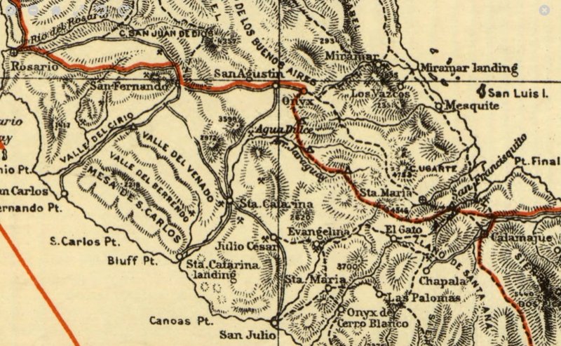
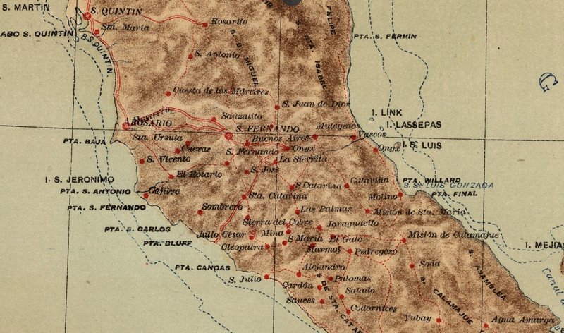
Some cool stuff here. Briefly discusses the coastal and central routes on pages 436 and 437. Might mention the water hole/ranch called La Sierrita up by San Fernando on the 1922 map posted earlier in the thread.

https://babel.hathitrust.org/cgi/pt?id=umn.319510022994597

[Edited on 10-29-2021 by Lance S.]


What a neat find... from 1856, all in Spanish, but a road log and water hole location of sorts for El Camino Real from La Paz north (what I glanced at)... Baja California begins on book page #427 (p.423) and ends on #441 (p.437).

Here is the Tinaja de Yubay description, Calamajué follows:


David K - 10-30-2021 at 04:30 PM

There was a good thread on this button back a bit, here on Nomad!

This was in 2015, and now, only my (and others) replies appear. The OP (original poster) removed his posts...? That Nomad had the handle 'Lancesf' !

Here is the thread (and I edited the Photobucket links so the images that were once sized to 800 pixels, until Photobucket stopped honoring their sizing settings, again fit)... http://forums.bajanomad.com/viewthread.php?tid=78559

David K - 10-30-2021 at 10:00 PM

Cool!