| Pages:
1
2
3 |
monoloco
Elite Nomad
     
Posts: 6667
Registered: 7-13-2009
Location: Pescadero BCS
Member Is Offline
|
|
| Quote: | Originally posted by unbob
| Quote: | Originally posted by monoloco
A bit more rain this season wouldn't be a bad thing. |
Sez who? I'm thinking more rain and standing water
means more skeeters and Dengue fever - a very bad thing. |
Sez the farmers and ranchers and anyone else who
depends on water pumped from the ground. It's been a very dry few years here and any water we get is appreciated.
"The future ain't what it used to be"
|
|
|
dorado50
Nomad
 
Posts: 118
Registered: 12-8-2011
Location: La Jolla, Ca.
Member Is Offline
|
|
looks to be worse the odile......bummer
|
|
|
mulegemichael
Super Nomad
   
Posts: 2310
Registered: 12-24-2007
Location: sequim,wa. and mulege
Member Is Offline
Mood: up on step
|
|
it's not worse than odile; it's apparent...but we don't need no more stinking rain....our main guy in mulege has dengue as does much of the
town....not good, methinks...he says to stay north as we will....just an INVASION of mosquitos with the rainfall....yeah; rain is good...AND...rain is
bad....find the balance...bigtime dengue fever problem in our little town; we will be staying north until the bugs is gone!!!
dyslexia is never having to say you\'re yrros.
|
|
|
bajabuddha
Banned
Posts: 4024
Registered: 4-12-2013
Location: Baja New Mexico
Member Is Offline
Mood: Always cranky unless medicated
|
|
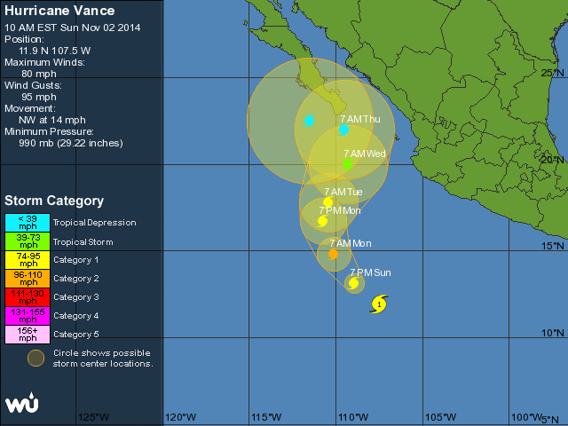
Vance is being squirrelly, can someone bring up the URL picture of this page I've bookmarked? I'm electronically challenged.
LATEST INFO:
http://www.wunderground.com/hurricane/eastern-pacific/2014/H...
Please pay attention to 5-day forecast
I don't have a BUCKET LIST, but I do have a F***- IT LIST a mile long!
86 - 45*
|
|
|
sargentodiaz
Nomad
 
Posts: 259
Registered: 2-20-2013
Location: Las Vegas, NV
Member Is Offline
|
|
DavidK - is the number of cyclones making landfall in Baja some kind of record?
|
|
|
vandenberg
Elite Nomad
     
Posts: 5118
Registered: 6-21-2005
Location: Nopolo
Member Is Offline
Mood: mellow
|
|
Latest on Vance

|
|
|
vandenberg
Elite Nomad
     
Posts: 5118
Registered: 6-21-2005
Location: Nopolo
Member Is Offline
Mood: mellow
|
|
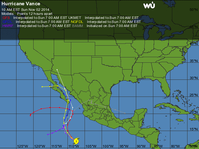
computer models with the promise of more rain 
[Edited on 11-2-2014 by vandenberg]

|
|
|
Sweetwater
Senior Nomad
  
Posts: 915
Registered: 11-26-2010
Member Is Offline
Mood: chilly today hot tomale
|
|
Just one degree centigrade increase in temperature of surface water contains a huge amount of energy if anyone chooses to do the math. I'm hoping that
those waters cool down and don't release that energy into the atmosphere along Baja and the mainland....it could make for a very wet
November....cheers and good fortunes to you.
Everbody\'s preachin\' at me that we all wanna git to heaven, trouble is, nobody wants to die to git there.-BB King
Reality is what does not go away when you stop believing in it. -Philip K Dick
Nothing is worse than active ignorance. Johann Wolfgang von Goethe(1749-1832, German writer, artist and politician)
When choosing between two evils, I always like to try the one I\'ve never tried before. - Mae West
Experience is what keeps a man who makes the same mistake twice from admitting it the third time around.
|
|
|
shari
Select Nomad
      
Posts: 13033
Registered: 3-10-2006
Location: bahia asuncion, baja sur
Member Is Offline
Mood: there is no reality except the one contained within us "Herman Hesse"
|
|
I see the outer bands of Vance are now combing the tip so can we begin the onsite reporting today with any rain reports por favor? gracias...I figured
we would be getting a late storm but thought it would be in October...jejeje...perhaps it would be wise to lay in stores and do some storm prep???
|
|
|
bajabuddha
Banned
Posts: 4024
Registered: 4-12-2013
Location: Baja New Mexico
Member Is Offline
Mood: Always cranky unless medicated
|
|
http://www.wunderground.com/hurricane/eastern-pacific/2014/H...
I just took a look at wunderground, and Vance is at the moment a CAT 2, and there's 95 E right on his back door; looks like a one-two punch. If I
were on South Cape I'd be hitting Costco before the sun sets today. Check out the satellite photo connection on the link.
Doesn't look threatening to central Baja, but ya never know.... Suerte y'all. 
I don't have a BUCKET LIST, but I do have a F***- IT LIST a mile long!
86 - 45*
|
|
|
Hook
Elite Nomad
     
Posts: 9006
Registered: 3-13-2004
Location: Sonora
Member Is Offline
Mood: Inquisitive
|
|
It's already changed back to going NE. And it appears it is at peak strength right now. Rapid weakening is expected as it is starting to show the
effects of wind shear.
Looks like Sinaloa will bear the brunt of the rainfall.

|
|
|
bajabuddha
Banned
Posts: 4024
Registered: 4-12-2013
Location: Baja New Mexico
Member Is Offline
Mood: Always cranky unless medicated
|
|
BUMP.
Vance is turning NW again, and 95E is behind.
East Cape folks,
Head's up. Suerte.
Yogi's still right (even though he was just a catcher).
I don't have a BUCKET LIST, but I do have a F***- IT LIST a mile long!
86 - 45*
|
|
|
Floatflyer
Nomad
 
Posts: 311
Registered: 2-15-2009
Location: Whidbey Island, WA
Member Is Offline
Mood: Wet & Cold
|
|
Started raining on East Cape about 6am. Winds maybe 15 +/- mph.
|
|
|
Whale-ista
Super Nomad
   
Posts: 2009
Registered: 2-18-2013
Location: San Diego
Member Is Offline
Mood: Sunny with chance of whales
|
|
Vance update from accuweather.com
Vance Weakens Slightly, Still a Danger to Mexico
By Kristina Pydynowski, Senior Meteorologist
November 4, 2014; 8:02 AM ET
More Sharing ServicesShare | Share on facebook Share on twitter Share on linkedin
An overview of the tropics is given in the above AccuWeather.com video.
Hurricane Vance weakened a bit Monday night, but still remains a dangerous storm as it continues on a path toward western Mexico.
Vance intensified to a hurricane Sunday morning as the tropical cyclone passed over the warm waters of the eastern Pacific and in an environment that
lacks disruptive wind shear, which can shred apart tropical systems.
The Mexican states of southern Baja California Sur, Sinaloa, Nayarit, Jalisco, Chihuahua, and Durango remain on alert for impacts from Vance through
Wednesday.
Rainfall has already begun across Sinaloa, Baja California and Nayarit, but the heaviest rain will move onshore Tuesday night into Wednesday.
Rainfall totals of 100-200 mm (4-8 inches) will occur across Sinaloa, Nayarit and Durango with amounts exceeding 300 mm (12 inches) in the mountains.
These are the areas most likely to experience flash flooding and mudslides.
Cabo San Lucas, Mazatlan and Puerto Vallarta lie within the zone of greatest risk from Vance.
[Edited on 11-4-2014 by Whale-ista]
\"Probably the airplanes will bring week-enders from Los Angeles before long, and the beautiful poor bedraggled old town will bloom with a
Floridian ugliness.\" (John Steinbeck, 1940, discussing the future of La Paz, BCS, Mexico)
|
|
|
Hook
Elite Nomad
     
Posts: 9006
Registered: 3-13-2004
Location: Sonora
Member Is Offline
Mood: Inquisitive
|
|
The Weather Underground analysis of Vance is very different, predicting that it may break apart before reaching land, in the face of significant
shear.
-------------
Conventional and microwave satellite data indicate that Vance is
losing organization due to the effects of 35-40 kt of vertical wind
shear. The cloud pattern has become elongated, and the low-levelcenter is near the southern edge of the convection. The initialintensity is lowered
to 75 kt based on various satellite intensity estimates, and this could be a bit generous.
The initial motion is 025/11. The GFS, ECMWF, GFDL, and Florida state superensemble models forecast Vance to move generally northeastward and make
landfall on the coast of Mexico in 24-36hours. The official forecast does likewise, and the new forecast is similar to that of the previous advisory.
It cannot be ruled out that Vance will completely shear apart before landfall, with the low-level center moving slower toward the northeast than
currently forecast.
The large-scale models forecast even stronger shear over Vance
during the next 24-36 hours, and this should cause rapid weakening.
The new intensity forecast follows this scenario and is in best
agreement with the SHIPS model. Although Vance could weaken to a depression by the time it makes landfall, given the uncertainties in intensity
prediction it remains prudent to have a tropical storm watch for portions of the coast of Mexico.
|
|
|
Hook
Elite Nomad
     
Posts: 9006
Registered: 3-13-2004
Location: Sonora
Member Is Offline
Mood: Inquisitive
|
|
The latest sat and Wundermap imagery shows Vance to be breaking up rapidly.
There's still a lot of moisture associated with it but most of it is headed east.
Light rain and winds <30 kts. is probably all that Baja is going to get. But there ought to be some big rollers heading up the Sea of Cortez by
Wed/Thur. I would imagine San Jose del Cabo is getting them right now.
|
|
|
Mexitron
Ultra Nomad
    
Posts: 3397
Registered: 9-21-2003
Location: Fort Worth, Texas
Member Is Offline
Mood: Happy!
|
|
This shows the next system again grazing the tip of Baja. But check out the whopper of an extratropical system forming in the Aleutians from the
remnants of Typhoon Nuri:
http://www.stormsurfing.com/cgi/display.cgi?a=npac_height
[Edited on 11-5-2014 by Mexitron]
|
|
|
Bob H
Elite Nomad
     
Posts: 5867
Registered: 8-19-2003
Location: San Diego
Member Is Offline
|
|
| Quote: | Originally posted by Mexitron
This shows the next system again grazing the tip of Baja. But check out the whopper of an extratropical system forming in the Aleutians from the
remnants of Typhoon Nuri:
http://www.stormsurfing.com/cgi/display.cgi?a=npac_height
[Edited on 11-5-2014 by Mexitron] |
That's a great link!!
The SAME boiling water that softens the potato hardens the egg. It's about what you are made of NOT the circumstance.
|
|
|
Osprey
Ultra Nomad
    
Posts: 3694
Registered: 5-23-2004
Location: Baja Ca. Sur
Member Is Offline
|
|
Here on the Tropic of Cancer, we were all witness to a most providential accident of weather >> just as hurricane Vance was about to break
everything again at the cape, a VERY STRONG weather system, a stream of high speed wind and rain, slammed into the storm pushing it south and east and
saving us from damage.
We are on that razor thin line between the crushing weather cell from Hawaii and the outer bands of Vance and watched the steering in real time as we
checked the animated satellite movement of the collision. Whew! Thanks.
|
|
|
woody with a view
PITA Nomad
      
Posts: 15937
Registered: 11-8-2004
Location: Looking at the Coronado Islands
Member Is Offline
Mood: Everchangin'
|
|
Deadliest Catch crews are getting pounded a little early this year!
|
|
|
| Pages:
1
2
3 |

