xplorbaja
Newbie
Posts: 15
Registered: 2-9-2006
Member Is Offline
|
|
El Marmol to Sea of Cortez M/C
I will be riding in Baja March 4th-10th and will try to make a route from El Marmol to the Sea of Cortez. Any info would be greatly appreciated. I
looked back on the other posts and it seems nobody has found anything promising.
|
|
|
David K
Honored Nomad

Posts: 64521
Registered: 8-30-2002
Location: San Diego County
Member Is Offline
Mood: Have Baja Fever
|
|
In the Trip Reports forum, I mentioned that I took a couple of the forks going north from the El Volcan road at Mi. 2.0 from El Marmol... Per my GPS,
I drew those trails onto this map. That northernmost point in the road was still not at the highpoint which was just a gentle climb ahead. In a m/c,
just continue cross country and you may be able to drop into Arroyo El Placer de los Perlita...?
As you may have found out from searching here, Corky and others (BillB, McGyver) have tried El Volcan wash (Zamora on the Almanac map) from both
ends... boulders and dry waterfall blocked the way.
Point A on the map is the dry waterfall that blocks easy m/c riding up from the east side...
Another attempt might be to go to La Olividada barite mine (6.3 miles past El Volcan... 10.3 from El Marmol) and see if you can cross country to the
gulf down Arroyo Miramar.
Finally, there is already a m/c trail known as the Bill Nichols trail that goes across Baja, without using auto roads... It begins south of
Puertecitos, near La Costilla... passes the mine operation and uses Arroyo Los Heme... from what I gather... m/c rider DAVEAU and friends used it last
Thanksgiving (met them at Baja Cactus in El Rosario) and left that trail north of El Marmol somewhere... coming out to Hwy. 1 near San Agustin...
Lastly, there is the El Camino Real from Mision Santa Maria to Gonzaga... has been done on a m/c (by Baja racer and Dust to Glory location producer
Kevin Ward)... but with a lot of damage to his XR from launching it over boulders that even give mules a hard time. In the thread on Mission
Impossible posted by Ken Cooke and Gonzaga trip by Bajaboy are details of the El Camino Real...
[Edited on 2-9-2006 by David K]
|
|
|
xplorbaja
Newbie
Posts: 15
Registered: 2-9-2006
Member Is Offline
|
|
Thanks. I think I will spend a day giving what you said a try (dump into Arroyo El Placer De Los Perita). If that does not work, I will take the Bill
Nichols trail from the HWY 1 side. I have been quite a ways up that wash from the Sea of Cortez side with my truck until my buddy in his truck said he
would go no further (to much body damage) I have had my truck at the El Camino Real from the top where the buldozer stopped and looked down towards
Gonzaga, that canyon is pretty big. If i have some extra time i might give that a try. I will probably be pretty beat up afer 5 days hard riding and
may just sit at Alfosina's and drink beer and eat fish tacos.
|
|
|
David K
Honored Nomad
Posts: 64521
Registered: 8-30-2002
Location: San Diego County
Member Is Offline
Mood: Have Baja Fever
|
|
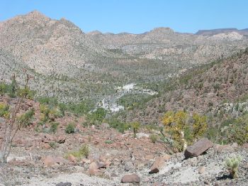
Sounds Great! On that bulldozed road past Mision Santa Maria is where the El Camino Real comes down off the mountain (coming up from the Gonzaga
desert... a point near where the big ruts in the bulldozed road make you get out and walk up to that canyon view with the petroglyphs...
The ECR stays out of that big canyon and is up on the ridge to the north...

Here is the view back west towards the mission from the top of the bulldozed grade... The Camino Real comes off the mountain on the right, in this
photo...
[Edited on 2-10-2006 by David K]
|
|
|
xplorbaja
Newbie
Posts: 15
Registered: 2-9-2006
Member Is Offline
|
|
we had 3 trucks we backed down when it did not go through.
|
|
|
xplorbaja
Newbie
Posts: 15
Registered: 2-9-2006
Member Is Offline
|
|
what is the ECR?
|
|
|
David K
Honored Nomad
Posts: 64521
Registered: 8-30-2002
Location: San Diego County
Member Is Offline
Mood: Have Baja Fever
|
|
EL CAMINO REAL (the Baja highway built by the padres and Indians to connect the chain of missions from Loreto to San Francisco, Calif. and other
missions in Baja).
GO HERE: http://www.vivabaja.com/ECR/
[Edited on 2-10-2006 by David K]
|
|
|
xplorbaja
Newbie
Posts: 15
Registered: 2-9-2006
Member Is Offline
|
|
short for El Camino Real, got it
|
|
|
xplorbaja
Newbie
Posts: 15
Registered: 2-9-2006
Member Is Offline
|
|
hey david, just wanted to say thanks for the plethora of information. We will be attempting this undone section in a few weeks.
if any more info is out there it would be appreciated.
|
|
|
David K
Honored Nomad
Posts: 64521
Registered: 8-30-2002
Location: San Diego County
Member Is Offline
Mood: Have Baja Fever
|
|
You are welcome!
However the 'payback' is a full trip report with GPS data!!! 
|
|
|
bajalou
Ultra Nomad
Posts: 4459
Registered: 3-11-2004
Location: South of the broder
Member Is Offline
|
|
And hopefully the GPS "track" if you have a way to download. They show up so great on the Sat. shots or digitized Topos.

No Bad Days
\"Never argue with an idiot. People watching may not be able to tell the difference\"
\"The trouble with doing nothing is - how do I know when I\'m done?\"
Nomad Baja Interactive map
And in the San Felipe area - check out Valle Chico area |
|
|
ArvadaGeorge
Nomad
Posts: 358
Registered: 9-2-2003
Member Is Offline
|
|
Some friends and I have done some investigation on this route. I think the best bet is East of El Huerfanito. In years past they did some placer
mining and I believe had trails to the Gulf. I know a biker that
Came down 1 of those canyons but they had to lower the bikes down rock ledges.
No way up.
I wish you luck.
|
|
|
mcgyver
Nomad
Posts: 444
Registered: 8-22-2003
Member Is Offline
|
|
ArvadaGeorge, I think you are right and I have expressed the same thought to David that someday some M/C will ride up and over one of those little
ridges and there will be the way to the gulf! All the old books that mention gold mining have hints about that area especially "El Placer de Los
Perita" directly east of Huferano and north of El Marmol. Some very rugged country out here, carry lots of water, it was 94* today at Matomi.
BAJA GOLD
|
|
|
Corky1
Nomad
Posts: 416
Registered: 11-22-2003
Member Is Offline
|
|
Hi xplorbaja,
I have tried this new route two times. Once from the east side and once from El Marmol area.
http://forums.bajanomad.com/viewthread.php?tid=2684#pid18137
http://forums.bajanomad.com/viewthread.php?tid=9903
My next trip the plan is to go to La Prosperidad mine location that is north of El Aguila.
If I can get my vehicle into the old mine site it will make easier
to do day trips trying to find a new route thru that area to the gulf coast.
If I can't get that far with my vehicle I will base camp at El Aguila.
My thought is to follow arroyo El Ronoso N/E to about 30-05 114-55.
Then go E/B to the beginning of El Placer de los Perita and out to the gulf coast.
Please keep me posted when as your trip gets near. Maybe I will invite myself along with you.
Corky 
 
\"Keep The Rubberside Down\" |
|
|
mcgyver
Nomad
Posts: 444
Registered: 8-22-2003
Member Is Offline
|
|
Corky 1,
Study this area closely on Google, it may give you some clues, David k. has a source for satellite photos also, maybe he can get something in that
area or have been to the La Prosperidad or El Rohoso mines recently.
It is only 100 meters difference in elevation between the head of El Placer de los Perita and Mina El Rohoso, of course it maybe all at once!! Let us
know , I will be standing by on Ch 21 and will drive up to Los Perita on the day you will be trying if you will keep me informed, they are supposed to
have internet at El Rosario.
I think it can be done!!
|
|
|
xplorbaja
Newbie
Posts: 15
Registered: 2-9-2006
Member Is Offline
|
|
You would be more than welcome to come along but I think I will save that section for another time. I will be based out of Gozaga. Plans have changed
a little. We will be heading out the morning of the 5th of March from Gonzaga and we will have no support or chase. This last weekend 2 of the more
hard core guys droped out. That left only me alone. Then 2 more guys decided to go. They are not as willing to do the more hard core stuff. Anyway we
were going to be doing a loop down to Bay of LA then over to the Pacific and back up and across somewhere,(that is when we were going to attemp that
section).
Now it looks like we will do that loop backwards and cross the Bill Nichols trail. I have not done this trail but i know where it starts from the Sea
of Cortez side. I should be able to take it over to the EL Ronoso down to La Prosperdad.
It will really depend on who actually shows up for the ride. I am pretty much wing'n it and just want to spend some time riding and camping off my
bike in Baja. It looks like I willl have about 5 days of riding time.
|
|
|