| Pages:
1
2 |
RICHARDH
Junior Nomad

Posts: 84
Registered: 11-15-2006
Member Is Offline
|
|
Big blank spaces on the AAA map -- are these (natural) wilderness areas?
I have now done most of my studying of conventional travel guides for Baja, and I'm ready to think more specifically about natural wilderness areas --
especially between Guerrero Negro and C. Constitution (and over to the Sea of Cortez).
Here are a few "big blank spaces" on the AAA map of Baja, and I'm wondering to just what extent these areas are natural wilderness areas. I don't
presently have access to a Baja California Almanac, which I understand has considerably more detail. So I suppose some of these "big blank spaces"
perhaps may actually be laced with primitive roads and jeep trails. And by the time I get a good look at an Almanac, it may be too late to do good
research on this question -- I may be on the way to (or in) Baja.
So I'd like to get some comments on these possibilities. Note that "wilderness" tends to mean a lot of different things to different people. When I
say "wilderness", I'm thinking maybe no one has ever been there before and certainly I'm not thinking of areas laced with jeep trails. However, I
will be interested in primitive roads for initial access purposes.
Here are some of the areas (from north to south):
1) the big gap between Hwy 3 and Hwy 5 and south of Laguna Salada
2) the huge, roughly quadrangular area bounded by SPM Park, San Quintin, El Rosario, Catavinia, El Marmol, and the Sea of Cortez, but excluding the
San Filipe Desert
3) the seemingly non-roaded triangular area with Mision San Borja, Villa Jesus Maria, and Punta San Francisquito as its vertices
4) the area east of the line between San Francisco de la Sierra and Mision Gertrudis
5) the "blank space" in the Vizcaino Desert between the Vizcaino-Bahia Tortugas road and the Punta Abreojos-Mex 1 road
6) the seemingly unroaded area between San Ignacio and Mision Guadalupe (ruins) and further to the southwest
7) the seemingly unroaded area between Mulege and La Purisma.
8) the "small", seemingly roadless area west of the line between the Comondus and San Javier
9) the area west of the agricultural region around C. Constitution and over to the Sea of Cortez
There are numerous smaller areas I've left out, but they could conceivably be quite good candidates for wilderness as well.
For example, the area of the Sierra de la Laguna looks fairly small on the map, but I've seen some scenic photos of vast, rugged mountains in that
area.
I imagine that the most appropriate access to remote wilderness areas may be by burro to at least carry provisions for several days and perhaps weeks,
but I'm thinking that my budget may only allow backpacking, which seems likely to limit my range and depth of penetration into wilderness.
So what are the possibilities, and what might I expect to find?
|
|
|
woody with a view
PITA Nomad
Posts: 15938
Registered: 11-8-2004
Location: Looking at the Coronado Islands
Member Is Offline
Mood: Everchangin'
|
|
rocks, lizards and dirt
|
|
|
Crusoe
Senior Nomad
Posts: 731
Registered: 10-14-2006
Member Is Offline
|
|
And even somemore rocks,lizzards and dirt plus alot of cactus and ants!
|
|
|
David K
Honored Nomad
Posts: 64524
Registered: 8-30-2002
Location: San Diego County
Member Is Offline
Mood: Have Baja Fever
|
|
Richard.... I am BBQing some elk for dinner right now, but I will get back to you a bit later with details on those areas!!! STAY TUNED!!!
|
|
|
David K
Honored Nomad
Posts: 64524
Registered: 8-30-2002
Location: San Diego County
Member Is Offline
Mood: Have Baja Fever
|
|
Okay, Area 1: See all posts with the subject 'Pole Line Road' (mostly made by Ken Cooke and Neal Johns)...
The WWII era telephone line service road (cobblestone) built by the U.S. between Ensenada and San Felipe goes through this area and makes a great Jeep
trip (or Toyota)... This was to communicate with our radar station there... in case the Japanese or Germans invaded us via the Gulf!
[Edited on 1-5-2007 by David K]

|
|
|
David K
Honored Nomad
Posts: 64524
Registered: 8-30-2002
Location: San Diego County
Member Is Offline
Mood: Have Baja Fever
|
|
Area # 2: http://vivabaja.com/1105/page3.html
[Edited on 1-5-2007 by David K]
|
|
|
David K
Honored Nomad
Posts: 64524
Registered: 8-30-2002
Location: San Diego County
Member Is Offline
Mood: Have Baja Fever
|
|
Area #3: http://vivabaja.com/703/page4.html
San Regis access road was gated, so couldn't get close to it!
Santa Ana, San Ignacito and San Regis were vistas for Mision San Borja... mission visiting stations in this region.

San Gregorio was also one, southeast from San Borja: http://www.davidksbaja.com/401/page5.html
[Edited on 1-5-2007 by David K]
|
|
|
Bajagypsy
Super Nomad
Posts: 1416
Registered: 8-31-2006
Location: Bahía Asuncion BCS
Member Is Offline
Mood: Living the dream
|
|
I'm a bit of a Google Earth freak for things just like this, any luck picking off faint trails in these areas this way?
|
|
|
David K
Honored Nomad
Posts: 64524
Registered: 8-30-2002
Location: San Diego County
Member Is Offline
Mood: Have Baja Fever
|
|
| Quote: | Originally posted by Bajagypsy
I'm a bit of a Google Earth freak for things just like this, any luck picking off faint trails in these areas this way? |
YES! If you are lucky enough to need a view of an area with the high resolution photos! Use my list to get close to the area you want to check out: http://forums.bajanomad.com/viewthread.php?tid=10620
|
|
|
David K
Honored Nomad
Posts: 64524
Registered: 8-30-2002
Location: San Diego County
Member Is Offline
Mood: Have Baja Fever
|
|
Area 4 is pretty sparse... along the coast is Trinidad... The El Camino Real had more than one route through this hostile area depending on the time
of year or which visita or rancheria the padres had to visit between San Ignacio and Santa Gertrudis.
Photo of El Camino Real in this region by Harry Crosby...

[Edited on 1-5-2007 by David K]
|
|
|
David K
Honored Nomad
Posts: 64524
Registered: 8-30-2002
Location: San Diego County
Member Is Offline
Mood: Have Baja Fever
|
|
Area 5 contains the mysterious looking Santa Clara Mountains and is home to one of Baja's lost mission legands... See http://vivabaja.com/1757
|
|
|
David K
Honored Nomad
Posts: 64524
Registered: 8-30-2002
Location: San Diego County
Member Is Offline
Mood: Have Baja Fever
|
|
Okay Richard, I gave you my input on the areas I have some info on and I hope the other Nomads can provide more for you...
The main answer to your question is there are blank areas on the AAA map because AAA hasn't mapped those areas or they removed the roads once shown
because they don't want to have unexperienced members drive into some areas, have vehicle or driving issues, and then blame the AAA for showing 'bad'
roads on their maps! Yes, this is a reason you see less roads than the older AAA maps once included.
The Baja California Almanac shows a whole lot more!
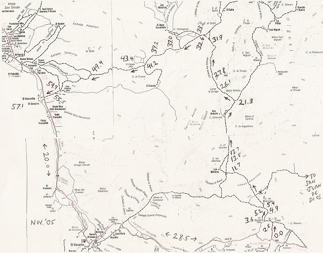
Here's just one area off the older Baja Almanac Norte to give you a hint to the detail, near Santo Tomas (ignore my notes on it)...
[Edited on 1-5-2007 by David K]

|
|
|
TMW
Select Nomad
Posts: 10659
Registered: 9-1-2003
Location: Bakersfield, CA
Member Is Offline
|
|
Richard print out a copy of the SCORE Baja 1000 race map and course notes from the last couple of years and follow it around to get a good look and
feel of the country side. A Baja Almanac would help too.
[Edited on 1-5-2007 by TW]
|
|
|
wilderone
Ultra Nomad
Posts: 3783
Registered: 2-9-2004
Member Is Offline
|
|
"So what are the possibilities, and what might I expect to find?"
The possibilities to backpack for a few days into wilderness is endless. However, as with any other wilderness area anywhere in the world, you will
first access your departure point by road. I predict that after a month of traveling excessively potholed, deep sand, washboard roads, you will hope
for a good dirt road to get you into the wilderness. Most places in the Baja CA desert containing some water source (spring, tinaja, river, lake),
which would make the area more hospitable for resident or wilderness seeker alike, has been discovered centuries ago and you will find some evidence
of habitation - abandoned rancho, hunting camp, old mining effort, etc. If you venture into a wilderness area that has no water, and you must carry
your own water, that will limit your range in the wilderness. You can take a dirt road several miles off Mex. 1 and be the only person there for days
- an area that hasn't changed for 1,000 years. So really not necessary to go where nobody else has stepped foot - the same cactus, rocks, lizards
will be found right next to the road too.
|
|
|
David K
Honored Nomad
Posts: 64524
Registered: 8-30-2002
Location: San Diego County
Member Is Offline
Mood: Have Baja Fever
|
|
Excellent advice Wilderone!
|
|
|
David K
Honored Nomad
Posts: 64524
Registered: 8-30-2002
Location: San Diego County
Member Is Offline
Mood: Have Baja Fever
|
|
Baja California Almanac
I scanned three of the maps from the now out of print last edition of the Almanac, then cropped and reduced the size to meet Nomad limits... As the
details get washed away when you reduce an image too much, I am not sure how much you will gain from these... But, it is probably enough to get you to
try very hard to get your own copy!
Here is your area #1 (south of Laguna Salada... part of the Pole Line Road shown as a dashed single line in the upper left quadrant)
[Edited on 1-5-2007 by David K]

|
|
|
David K
Honored Nomad
Posts: 64524
Registered: 8-30-2002
Location: San Diego County
Member Is Offline
Mood: Have Baja Fever
|
|
Area 3 (Mision San Borja/ Villa Jesus Maria)

|
|
|
David K
Honored Nomad
Posts: 64524
Registered: 8-30-2002
Location: San Diego County
Member Is Offline
Mood: Have Baja Fever
|
|
Area 4 (south of Santa Gertrudis)
part of two pages here, with the binding gap...

|
|
|
David K
Honored Nomad
Posts: 64524
Registered: 8-30-2002
Location: San Diego County
Member Is Offline
Mood: Have Baja Fever
|
|
Here's a close up of the area from San Borja and south...
Circled are San Borja and the visitas of San Ignacito, Santa Ana, San Gregorio, and San Regino (San Regis)... Also the El Camino Real is shown
(E.C.R.) as a dashed line and I pointed out the onyx mine of El Marmolito... whose ore was shipped out from Miller's Landing, to the west.
The road between San Borja and Santa Ana was pretty bad and overgrown from lack of use when I went there and the road to San Regino had a locked gate
just east of El Cardonal, so I couldn't get up to see the mission visita ruins and graveyard there.
[Edited on 1-7-2007 by David K]

|
|
|
David K
Honored Nomad
Posts: 64524
Registered: 8-30-2002
Location: San Diego County
Member Is Offline
Mood: Have Baja Fever
|
|
Santa Ana
Graves along the road at the abandoned rancho and former San Borja mission visita of Santa Ana... Large tombs photo taken by 'BajaTaco' (Chris)
Looking the other direction towards the palms, over a simpler grave next to the big ones, is this photo I took in '03:

[Edited on 1-5-2007 by David K]

|
|
|
| Pages:
1
2 |


