| Pages:
1
2 |
Geothermal-Shane
Junior Nomad

Posts: 83
Registered: 5-14-2005
Member Is Offline
|
|
Sierra de San Pedro Martir: 05-2008
We arrived at Corona de Arriba at approximately 1 pm on Monday, May 5, myself and a friend by the name of Cristales. To my immidiate surprise, we
found that the Observatorio Road has now been paved all the way to the ranger station at 8200'(2500 m), making for a somewhat faster trip from the
Pacific Coast, though unfortunately this road has also been closed in by barbed wire fencing on both sides clear to the park entrance, taking away
from the region's feeling of grand wide openess.
Anyhow, we had to pay $4 dollars for each day we planned to stay, which was a week, totaling about $20 each, and were then admitted into the park.
Just let my say that this place is truly amazing- shortly after leaving la Corona, the road takes you into a region that could best be classified as
the "Mexican Boreal Forest". complete with fir, aspen and lodgepole pine. The aspens, this early in may, evidently had yet to sprout any leaves. We
eventually ended up taking the very rough dirt road to La Tasajera, having to find our way around numerous fallen trees en route, and after the
especially slow drive, finally arrived at the northern boundary of this spectacular meadow only to find the road completely impassable by a fallen
tree that could not be avoided. We made this our first camp, where I was mind boggled to find lodgepole pines doing very well at an altitude of
7700'(2400 m). The only reasonable explanation I can come up with for why such thirsty high altiude/latitude trees could survive at low latitude and
at an altitude comparably lower to the habitat of other lodgepoles is that they can survive in the rich and moist meadow soils. It is notable, that
the lowest lodgepoles I have ever found in California's southernmost lodgepole community(San Jacinto Mts.)were at 8600'(2600 m) and growing
exclusively on north facing slopes(Tahquitz Peak, Round Valley, etc.).
Anyhow, the next day we loaded our bags with as much food as we could carry and began the long, grueling, steep trek down to La Grulla Meadow, which
we ultimately reached about six hours later. The route finding was far easier than I had anticipated. the trail shown on the Jerry Schad SSPM map does
exist and is amazingly accurate. Even more amazing was that this trail hadn't a single human track on it!
Along the way I picked up a stunning peice of glacial polished granite- testament to this range's natural history and the likely glacial creation of
these meadow/lake basins.
After descending the long bouldery canyon from the higher plateau, we came out into breathtaking Ranco Viejo Meadow, complete with bustling cumulus
clouds- a pure Sierran scene, but then had trouble finding La Grulla. We ended up following Rancho Viejo's creek downstream until we intersected the
trail connecting La Zanja and La Grulla, which we followed East and ultimately led us right to the foot of this other worldly meadow.
La Grulla is at an altitude just under 6800' (2000 m), and suprisingly, it seemed we had come a bit early in the season. The air was cool, about 60
degrees at the most, and shortly after our arrival, the WINDS started to pick up, making this pleasant temperature feel absolutely unbearable. The
great cloud formations noted as we passed Rancho Viejo were growing to mighty proportions, dominating the sky and posing a real threat of rain.
Although I hadn't brought a tent, La Grulla is one particular place that is among the most ideal of natural mountain shelters, being heavily adorned
with literally house sized boulders that, here and there, provide a sheltered niche just to the specifications of sleeping.
Also, it was here that we found our first REAL RUNNING WATER, gushing from the mouth of the meadow into an algaeic creek. Even after being filtered
the water had a yellowish color, but tasted fine.
By nightfall, we managed a crude, small campfire and caught ocassional glimpses of lightning flashing to the northwest. Cooked quinoa and red
lentils over the open fire to be concluded with COLD tecate and shots of
tequila. over the open fire to be concluded with COLD tecate and shots of
tequila.
Next day, after the fortune of a dry but wind blown night, we awoke to more big clouds and persistent gales that sent every peice of our camp not
staked down flying away.
Finally, we made the decision to attempt to find La Encantada Meadow. We left our camp with only water bottles and started east on the good but
unmaintained trail across the north side of La Grulla- this meadow is HUGE- it unveiled itself to us, stretching off in many distant directions. it
took nearly an hour to finally get out of La Grulla and into the sparsely forested slopes to the north, much of which had suffered extensive fire
damage at one point, but was recovering remarkably well. Unlike severe burn areas of So. California, these devastated stands of Jeffery Pine had
clealry survived fire and continued to grow healthy and tall.
Finally we reached and crossed the outlet of La Encantada and eventually were spit out at the Meadow itself, at an altitude of 7000' (>2100 m). To
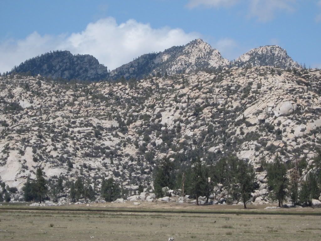
those who have been, there is no question as to how this place got its name. This expansive valley extends for miles in every direction, particularly
from north to south, and would probably take days to thoroughly explore. To the north, the scenery is especially enchanted by the towering summits of
Big Picacho, Cerro la Botella Azul and Las Tres Palomas, all rocky white and granitic, dotted with little green pine trees- true Sierra scenery.
Unfortunately, by the time we finally reached Encantada, the winds had become so fierce as to render this place incapable of harboring a soul. As if
these mountains were really telling us, "Get out of here, you don't belong, you have no place- go back to La Grulla!"
So we quickly left to escape the brutal winds that seemed to funnel right through that valley like it was a ventilation duct.
It was thoroughly hard to believe that just on the other side of those peaks was the San Felipe desert.
By late afternoon we were home and luckily the winds began to subsist.
The next day we were utterly relieved to wake up to a clear warm morning, and dutifully began the steep haul back up to La Tasajera. Somewhere around
the 7500' level we encountered Incense Cedar, Sugar Pine and Aspen, and realized, that the only tree species we had seen for almost three days
straight was Jeffery Pine- all over the lower meadowed basins, incredible that this tree could dominate such an extemnsive acerage. After three or
four hours we reached the truck- still ice in the ice chest stashed underneath a thicket of lodgepoles. We happily slogged tecates as we managed the
rough and slow ride back up to Vallecitos, where we had a difficult time finding any water at all. Finally we spent considerable time and effort to
filter several gallons from the hardly flowing trickle in an unnamed ravine just below Viveros(the Observatory Modulos).
We camped along the road to Aguaje del Burro in the serene setting of huge boulders, lodgepole, white fir and jeffery pine. Amazing to be in such a
raw place yet free from the crowds of the Sierra.
Next day, it was up and early to reload the packs and over to the Picacho trailhead, where we feebly began stumbling into the Sierra de San Pedro
Martir's true alpine country. Again, the availability of water was very poor, but we managed to find another scant trickly just east of the "Aspen
Grove", where, strangely, many of the aspens were full with sprouting green leaves. (?) Beyond here, as all you Picachoites know, the trail grows
steep and especially rugged, and the route finding arduous. Fortunately for us, according to the park ranger, a team of 40 climbers(todos Mexicanos)
had just passed through a few days earlier en route to Picacho, making the route finding fairly simple.
By about 4 pm we reached Scout Jct., and began to wonder why I had decided to carry all this beer which was making this hike harder than it should be.
We stopped by a stagnant water hole to fill up our bottles like we were posing for an MSR catalogue. Lo and behold, on both sides of this hole were
two mighty and sacred SSPM cypress trees(cuprusses montana), both healthy, green and cone bearing.
Further down canyon I could spot a few others, all at an altitude just below 9000' (2700 m), leading me to beleive that this tree is exclusively a
highland conifer.
After this splendid discovery we began slogging up toward Scout Peak, full packs, and by the time we were really questioning our own sanity, were
standing on the edge of the plateau with views that can hardly be explained- desert, mountain, forest and sea, all there to be taken in boundlessly.
We surrendred at the notch just South of the Scout summit and after a short break, made the final ascent of this magnificent peak. here, also, all
along the edge of the plateau were scattered cypress trees, some with the most impressive gnarled and wind swept appearance, looking ancient like
Bristlecone Pines. Sugar Pines, too, grow dwarfed and wind swept atop this high remote outpost.
The view from Scout Peak(9362' ?) (>2800 m)is absolutely comparable to the postcard images of Yosemite Valley, complete with multiple thousands of
feet of hanging granite cliffs that descend into forbidden looking Canon del Diablo.
Further delighted by the endless miles of red and orange desert that extend all the way to the mysterious blue waters of the California Gulf.
We eventually returned to the notch and our packs to make camp in this amazing setting, complete with the unrestrained greatness of the Picacho
looming overhead as if to say, "heh heh, good luck getting up here!" We opted against fire this night as the wood is sacred and scarce.
Next day, up and early again with loaded pack we return to scout junction and decide to drop our packs there and make an attempt at ascending Cerro la
Botella Azul, second highest mountain on the Baja Peninsula. The route finding was equally fair as the previous day. We even found a trickle of water
several yards off trail that we were able to filter, which was colorless and tasted like the very blood of the mountain. Beyond here the trail becomes
extremely steep and rough as it works its way through a canyon dense with aspen, brush and boulders, and the actual "trail" is lost to scattered
strips of neon tape that come in very handy when there is the question of "well, which bush to go plodding through now?" Finally, if you are stocked
full of fortitude, you come out at the infamous BLUE BOTTLE SADDLE, where, as Cristales and I had gotten many yards apart, we arrived from different
directions, following different routes of neon tape. 
From there it was, literally, straight up the mountain through an immensely dense field of stunted apens, all sprouting small green leaves. The trick
here was just finding your way through these things, along with ocassional thorn bush that would help to wake us up. Finally, somehow, we reached the
base of the summit and made the final nearly helpless ascent of the single truck sized boulder the marks the top of the plateau at 9680', (>2900
m).
This is alpine Baja!!!!
At the summit of Botella Azul is a unique community of trees found nowhere else on earth in such a combination: lodgepole pine, dwarf aspen and SSPM
cypress
It might be unfair to describe the view to those who have never seen it, but I'll hint that it includes nearly ALL of the SSPM meadows and views into
Valle Chico far beyond Matomi Canyon. Perhaps one of the distant hazy Gulf peaks was Volcan Prieto south of Puerticitos.
Needless to say, this was a VERY hard place to leave, but sooner or later you have to. Would be a great place to camp except for the demanding climb
to get there.
Eventually we got back to the trailhead that day, and en
route, ran into a group of four locals with an old gringo. These were the first people we had seen in five days! I hardly knew what to say. Cristales
shared some spanish and we all carried on.
What happened that evening may be beyond the scope of this internet to describe, but I will say we had the fortune of reaching Ensenada the next day
with our very selves still intact...
[Edited on 6-25-2008 by Geothermal-Shane]
|
|
|
longlegsinlapaz
Super Nomad
Posts: 1685
Registered: 11-18-2005
Location: La Paz
Member Is Offline
|
|
This trip report is screaming for accompanying pictures! Please! Although you do an excellent job of painting pics in your narrative. Please! Although you do an excellent job of painting pics in your narrative.
|
|
|
David K
Honored Nomad
Posts: 64488
Registered: 8-30-2002
Location: San Diego County
Member Is Offline
Mood: Have Baja Fever
|
|
Yes... great stuff indeed. I am anxious to hear if you went to La Grulla to see the foundation stones from the first site of Mision San Pedro Martir?
"Founded 210 years ago by Dominican Padre Jose Loriente in April, 1794 at a site called Casilepe (La Grulla meadow) 8 miles away and 2,000 feet
higher. By the end of August, 1794, the cooling weather forced a move down to 5,068 feet above sea level, where this mission remained until its
closing between 1806 and 1824. The remaining mission Indians were moved down to Mision Santo Domingo."
The above quote is from my web page on San Pedro Martir: http://www.vivabaja.com/bajamissions/page12.html (photos)
|
|
|
Barry A.
Select Nomad
Posts: 10007
Registered: 11-30-2003
Location: Redding, Northern CA
Member Is Offline
Mood: optimistic
|
|
David---------fasinating stuff!!! I spent 3 days camped out at La Grulla back in the early '50's, and never saw, or knew, of that information. I
sure wish I had known what to look for, way back then. Nomad "Vince" was with me on that campout.
barry
|
|
|
David K
Honored Nomad
Posts: 64488
Registered: 8-30-2002
Location: San Diego County
Member Is Offline
Mood: Have Baja Fever
|
|
Barry, the site at La Grulla was only recently discovered! I belive there are photos of the stones online... Max Kurillo showed me, I believe.
|
|
|
Barry A.
Select Nomad
Posts: 10007
Registered: 11-30-2003
Location: Redding, Northern CA
Member Is Offline
Mood: optimistic
|
|
Ah Ha---------thanks David, that makes me feel not quite so disturbed in what I missed----------Now I wish that Vince and I had been the one to
discover the site
Barry
|
|
|
Mexitron
Ultra Nomad
Posts: 3397
Registered: 9-21-2003
Location: Fort Worth, Texas
Member Is Offline
Mood: Happy!
|
|
Re--the Lodgepole Pines--they are well known to grow in the extremes of both dry and wet conditions--apparently happy to not have the competion of
other trees in those situ. Also, the San Pedro Martir has a rather moderate climate year-round and general lack of droughts as attested by the
consistent growth rings in their trees, as opposed to more fluctuation in the, for instance, trees in the Sierra Nevada.
Thanks for the cool post! Love that place.
|
|
|
David K
Honored Nomad
Posts: 64488
Registered: 8-30-2002
Location: San Diego County
Member Is Offline
Mood: Have Baja Fever
|
|
Barry, here's a thread from 2005 that you and Mexitron also were on, re. the La Grulla site. Dr. Jackson (academicanarchist) also had some info: http://forums.bajanomad.com/viewthread.php?tid=14028
|
|
|
David K
Honored Nomad
Posts: 64488
Registered: 8-30-2002
Location: San Diego County
Member Is Offline
Mood: Have Baja Fever
|
|
Here is the paper on Mision San Pedro Martir: http://www.pcas.org/Vol33N3/333Fostr.pdf
The discovery of the first site is described...
Max Kurillo was with us at Viva Baja Cactus... He is the co-author of 'California's El Camino Real' and appeared on Huell Howser's show about the
bells of El Camino Real.
|
|
|
Barry A.
Select Nomad
Posts: 10007
Registered: 11-30-2003
Location: Redding, Northern CA
Member Is Offline
Mood: optimistic
|
|
Wow, thanks David. I remember that conversation now-----it was good to go back and read the attachments again.
La Grulla is a "must" see for all who get the chanch----simply beautiful!!! Our Mexican guide shot a deer while there (we ran out of food) and we
feasted on venison------I clearly remember the guide only shot his 30/30 one time-----and got his deer. That was the best meal----we were pretty
hungry----ate venison for the next few days.
Barry
|
|
|
David K
Honored Nomad
Posts: 64488
Registered: 8-30-2002
Location: San Diego County
Member Is Offline
Mood: Have Baja Fever
|
|
Barry, do read the paper http://www.pcas.org/Vol33N3/333Fostr.pdf as it describes the discoveries in La Grulla (in 1991) and has a mission floor plan map (actually just
shows were the foundation stones were, etc.).
Have a great day... I am off to la dentista  then to do some
irrigation designs! then to do some
irrigation designs!
|
|
|
Barry A.
Select Nomad
Posts: 10007
Registered: 11-30-2003
Location: Redding, Northern CA
Member Is Offline
Mood: optimistic
|
|
| Quote: | Originally posted by David K
Barry, do read the paper http://www.pcas.org/Vol33N3/333Fostr.pdf as it describes the discoveries in La Grulla (in 1991) and has a mission floor plan map (actually just
shows were the foundation stones were, etc.).
Have a great day... I am off to la dentista then to do some
irrigation designs! |
OUCH!!!! Thanks, David, I will check it out.
WE are off to Utah tomorrow for 3 weeks of exploring the MAZE, and the surrounding country, by 4x4 .
Barry
|
|
|
CaboRon
Ultra Nomad
Posts: 3401
Registered: 3-24-2007
Location: The Valley of the Moon
Member Is Offline
Mood: Peacefull
|
|
Geothermal-Shane,
Thanks for shareing your trip report ... perchance you have some pics which you can post later ?? Hope so.
CaboRon
|
|
|
BAJACAT
Ultra Nomad
Posts: 2902
Registered: 11-21-2005
Location: NATIONAL CITY, CA
Member Is Offline
|
|
while he post his pict, I will put one of mine I hope nobody gets offend it.
This pix, is from last years Memorial day weekend

BAJA IS WHAT YOU WANTED TO BE, FUN,DANGEROUS,INCREDIBLE, REMOTE, EXOTIC..JUST GO AND HAVE FUN.....
|
|
|
Ken Cooke
Elite Nomad
Posts: 8921
Registered: 2-9-2004
Location: Riverside, CA
Member Is Offline
Mood: Black Trans Lives Matter
|
|
Thank you for this information. I enjoyed reading about La Tasajera being "impassable." I ran into a fallen tree on the Venado Blanco trail leading
to Rancho Viejo, and I carried the fallen tree away, piece by piece.


Parked at Rancho Viejo - Ken & Andrew's vehicles.

The "La Tasajera" road.

...but wait, it gets interesting!
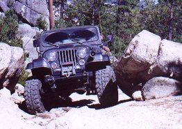

This road leads to a meadow and stream containing trout that are endemic to the Sierra San Pedro Martir. The road leading to the meadow is a dusy,
and you had better be equipped, or you'll be calling for help.
|
|
|
Vince
Nomad
Posts: 445
Registered: 10-17-2006
Location: Coronado
Member Is Offline
|
|
Great reading Geothermal-Shane and excellent photos, Ken. What Barry didn't mention on that trip in the early '50's was that deer that was shot
attracted a mountain lion that night while it was draining, hung from a tree. The lion got his share before we did, but it was a trip to remember!
Love these stories, always makes me want to revisit the Meling ranch and above mountains.
|
|
|
Geothermal-Shane
Junior Nomad
Posts: 83
Registered: 5-14-2005
Member Is Offline
|
|
I am attempting to upload some pictures but i have noticed this files are too big. having a hard time since i am not that good with computers.
http://www.youtube.com/watch?v=ToZ0oGDtcZA
[Edited on 6-21-2008 by Geothermal-Shane]
|
|
|
Ken Cooke
Elite Nomad
Posts: 8921
Registered: 2-9-2004
Location: Riverside, CA
Member Is Offline
Mood: Black Trans Lives Matter
|
|
| Quote: | Originally posted by Geothermal-Shane
I am attempting to upload some pictures but i have noticed this files are too big. having a hard time since i am not that good with computers.
|
Send them to me, and I can host them on my website if you like. Send me a U2U and I will give you my email addy.
|
|
|
Sharksbaja
Elite Nomad
Posts: 5814
Registered: 9-7-2004
Location: Newport, Mulege B.C.S.
Member Is Offline
|
|
What a great trip! Wish I was there right now!
Pics would be great. I'd like to see those wind-shaped cypress trees.
DON\'T SQUINT! Give yer eyes a break!
Try holding down [control] key and toggle the [+ and -] keys
Viva Mulege!
Nomads\' Sunsets
|
|
|
thebajarunner
Ultra Nomad
Posts: 3687
Registered: 9-8-2003
Location: Arizona....."Free at last from crumbling Cali
Member Is Offline
Mood: muy amable
|
|
Baja Vida and I camped up there last year for a few days,
(close to the road, but still a great adventure)
No lack of water then, it was July and the massive thunderstorms rolled through every afternoon, right on schedule.
And dumped copious amounts of water all over everything....
The cab of the pickup was the only secure spot to sit them out.
But a great show, nonetheless.
Great report!!!
|
|
|
| Pages:
1
2 |
|