| Pages:
1
2 |
Pacifico
Super Nomad

Posts: 1299
Registered: 5-26-2008
Member Is Offline
|
|
David,
Are pretty happy with Geoeye? It looks great! I quickly looked at their website - I take it that it has to be purchased? Looks a lot better than
Google Earth.
Thanks!
|
|
|
David K
Honored Nomad
Posts: 64493
Registered: 8-30-2002
Location: San Diego County
Member Is Offline
Mood: Have Baja Fever
|
|
| Quote: | Originally posted by rob
Dave,
I bought the Lower California Guidebook (you talked about it on another thread) for $8 - it's pure gold! It even mentions our ranch (although just " .
. .off to the left is Rancho Aguja . . ").
Outstanding Googling. |
Yes, it is a classic... a superior work of research by the authors! I have every edition, they're great!

|
|
|
David K
Honored Nomad
Posts: 64493
Registered: 8-30-2002
Location: San Diego County
Member Is Offline
Mood: Have Baja Fever
|
|
| Quote: | Originally posted by Pacifico
David,
Are pretty happy with Geoeye? It looks great! I quickly looked at their website - I take it that it has to be purchased? Looks a lot better than
Google Earth.
Thanks! |
Am I pretty happy with Geoeye?
I never heard of it before this... I checked it out and the sample I looked at (in Baja) was blurry up close...?
Google Earth for 3-D images and Wikimapia.org for straight down images... I can spend hours there... 
|
|
|
David K
Honored Nomad
Posts: 64493
Registered: 8-30-2002
Location: San Diego County
Member Is Offline
Mood: Have Baja Fever
|
|
The previous section, Santa Maria to San Borja (ECR-1) is here: http://forums.bajanomad.com/viewthread.php?tid=37019
The 'Golfo' Camino Real south from San Borja (ECR-2b) is here: http://forums.bajanomad.com/viewthread.php?tid=36065
The next section south (ECR-3a): Santa Gertrudis to San Ignacio is here: http://forums.bajanomad.com/viewthread.php?tid=36578 (The Pacifico route)
[Edited on 2-25-2009 by David K]
|
|
|
katiehem
Newbie
Posts: 1
Registered: 11-24-2009
Member Is Offline
|
|
I didn't know Baja could be that wonderful. Thanks for sharing this one..
Regards,
katiehem
Pret travaux
|
|
|
David K
Honored Nomad
Posts: 64493
Registered: 8-30-2002
Location: San Diego County
Member Is Offline
Mood: Have Baja Fever
|
|
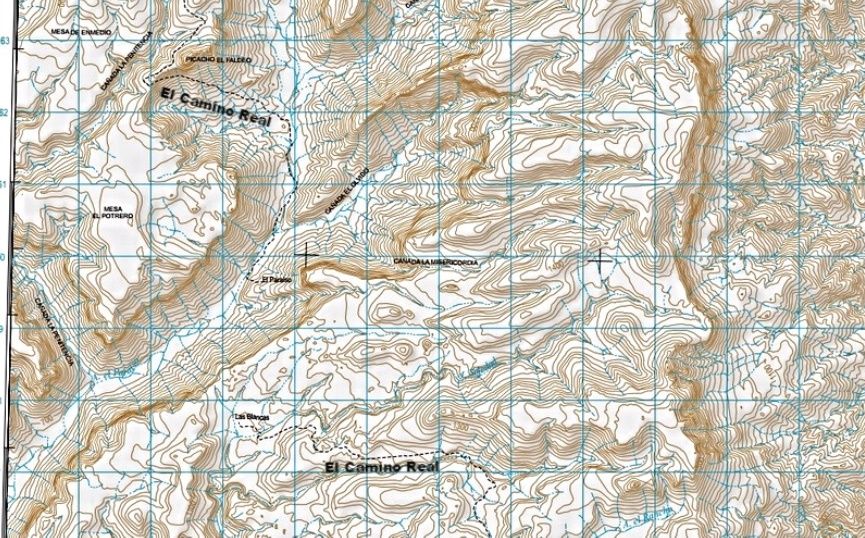
Here is the INEGI topo map of the region areound El Paraiso Canyon and most of EL CAMINO REAL across this map is shown... (I added the labels for it):
|
|
|
güéribo
Nomad
Posts: 239
Registered: 10-17-2014
Member Is Offline
|
|
Nice, David. Where did the map come from?
|
|
|
David K
Honored Nomad
Posts: 64493
Registered: 8-30-2002
Location: San Diego County
Member Is Offline
Mood: Have Baja Fever
|
|
It is a close up of an INEGI topo map, and I added the 'El Camino Real' labels to it along the mission road.
Here is PaulW's thread on how to see ALL of the Baja topo maps, online... scroll down for newer links and full peninsula key map: http://forums.bajanomad.com/viewthread.php?tid=77815
|
|
|
carlosg
Senior Nomad
Posts: 504
Registered: 5-28-2012
Location: chula vista, ca
Member Is Offline
Mood: Just like in Baja: No Bad Days...
|
|
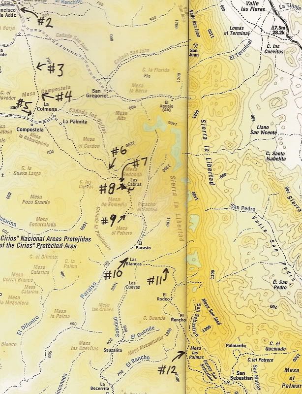
Quote: Originally posted by David K  | Close up of the Camino Real area... The numbers are the photos/ satellite images... Number one is San Borja, at the top... another map is below after
the next group of photos...
[Edited on 12-25-2008 by David K] |
Hi David,
This is a really interesting post, me and my family will be doing a "Central Baja Loop" (http://forums.bajanomad.com/viewthread.php?tid=78833#pid9811...) in early fall and I have done some research as to where our path will cross the
ECR, it seems like this will happen when we drive back from Santa Gertrudis, north of Miraflores, SSE from Cerro El Premiado on our way to El Barril,
as I was following the ECR trail from Santa Gertrudis to San Borja I noticed that on the 2009 Baja California Almanac point #10 is named as "El
Paraiso" instead of "Las Blancas" (names switched) The post "Las Flores" by "vacaenbaja" (http://forums.bajanomad.com/viewthread.php?tid=57252) shares very interesting info on BoLA and will guide our exploration path on this trip as
well. If you have any suggestions for our LOOP (http://forums.bajanomad.com/viewthread.php?tid=78833#pid9811...) please share it, this will be an exciting adventure and education for our family
specially for my children.
|
|
|
David K
Honored Nomad
Posts: 64493
Registered: 8-30-2002
Location: San Diego County
Member Is Offline
Mood: Have Baja Fever
|
|
| Quote: Originally posted by carlosg | | Quote: Originally posted by David K | Close up of the Camino Real area... The numbers are the photos/ satellite images... Number one is San Borja, at the top... another map is below after
the next group of photos...
[Edited on 12-25-2008 by David K] |
Hi David,
This is a really interesting post, me and my family will be doing a "Central Baja Loop" (http://forums.bajanomad.com/viewthread.php?tid=78833#pid9811...) in early fall and I have done some research as to where our path will cross the
ECR, it seems like this will happen when we drive back from Santa Gertrudis, north of Miraflores, SSE from Cerro El Premiado on our way to El Barril,
as I was following the ECR trail from Santa Gertrudis to San Borja I noticed that on the 2009 Baja California Almanac point #10 is named as "El
Paraiso" instead of "Las Blancas" (names switched) The post "Las Flores" by "vacaenbaja" (http://forums.bajanomad.com/viewthread.php?tid=57252) shares very interesting info on BoLA and will guide our exploration path on this trip as
well. If you have any suggestions for our LOOP (http://forums.bajanomad.com/viewthread.php?tid=78833#pid9811...) please share it, this will be an exciting adventure and education for our family
specially for my children. |
Hola Carlos,
I am very happy to offer suggestions or provide data so your Baja vacation is as enjoyable and educational as possible!
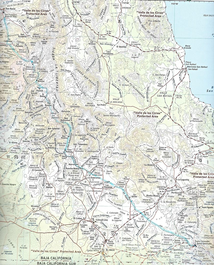
Yes, the 2009 Baja Almanac does reverse the names. El Paraiso is indeed in Cañon El Paraiso, as the 2003 Almanac shows. My point #10 corresponds to
the satellite image #10 in that thread, between the two ranchos, showing the Camino Real (a section of dashed line not on the Almanac map).
The Camino Real going north from Santa Gertrudis can be seen as it climbs up from the modern road just a mile or so west of the mission, as the road
hugs the left hill (a sign was there 'El Camino Real a San Borja' once). Sat image #26.
The Camino Real can also be seen where the shortcut road to San Francisquito crosses it (Sat image #23) and where the El Arco/San Francisquito road
crosses it (Sat image #22). The north side has been turned into an auto road to Rancho La Union.
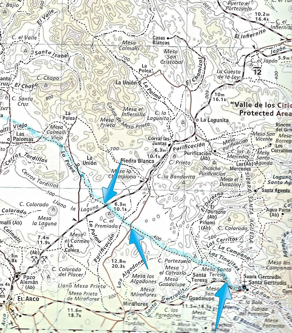
On the 2009 Almanac, here is the Camino Real, in light blue highlight, between Santa Gertrudis and San Borja:
Here are the three places where it can easily be spotted crossing modern roads (if you drive slow enough):
The Vacaenbaja posts are of John Hilton's 1959 articles in Desert Magazine (and later in his book 'Hardly Any Fences', c1977 Dawson Book Shop #38.)
Let me know how else I can assist!
|
|
|
| Pages:
1
2 |