| Pages:
1
2 |
David K
Honored Nomad

Posts: 65595
Registered: 8-30-2002
Location: San Diego County
Member Is Online
Mood: Have Baja Fever
|
|
Where is that old Baja road, you ask? (re-post)
For the interest of new Nomads (and old), here is an article on more recent Baja history I first posted in 2003:
posted on 12-13-2003 at 06:48 PM
Where is that old Baja road, you ask?
I am refering to the pre-December, 1973 Baja main road. Everything changed after December 1973 as far as Baja travel and number of visitors.
I was just a kid when my folks and I drove to the tip in 1966 in our Jeep Wagoneer. But, I was already infected with Baja Fever and my favorite book
was Gerhard & Gulick's LOWER CALIFORNIA GUIDEBOOK (The Baja Bible).
We went to Gonzaga Bay the year before (1965) and to L.A. Bay the following year (1967). The next trip down to Baja Sur (to Loreto) was in July, 1973.
The highway was under construction in mid '73 and I took many notes and mileages as to its location compared with the old road.
That July, pavement ended at the Mision San Fernando junction (near El Progreso) and didn't start again until near Punta Prieta (in sections), with
solid pavement starting about Villa Jesus Maria. We were on the old Baja main road from Agua Dulce (10 miles beyond San Agustin) to almost Laguna
Chapala. We didn't know so much of the old road would be driven from the reports we heard. The trip was made in our (2WD) Ford LTD station wagon!
The old road locator:
Just east of where the highway crosses Arroyo El Rosario (headindg south) is where the old road left the valley using a side canyon. The new road
stays above that canyon, just to the west.
The old road crosses the new and parallels it to the south, Rancho Aguajito and the turquoise mines are along it, below and south of the new highway.
El Progreso was moved north a half mile to the highway from the old road.
The road left to Rancho Penjamo is along the old road, as is Aguila and Guayaquil. The highway stays 1-2 miles to the west or southwest of the old
road until 2 miles from Cataviña.
The abandoned Pemex and trailer park 'San Agustin' is south of the original San Agustin, on the old road, as is Cafe Sonora a couple miles ahead.
Agua Dulce is off the old road, a couple miles to the left of Km. 157-159. The old road stays about 1-2 miles east/left of the highway in the La
Virgen boulder area. The old road rejoins the highway just before the ruined palapa by the rock art cave, 2 miles before Catavina.
The highway is next to the old road past San Martin and over to the first little dry lake. At the Pedregroso boulder mountain, the old road went
around the west side, whereas the new highway goes around the east side.
At the first sight of the Laguna Chapala valley, the old road continued straight towards the old ranch site, along a little hill just north of the dry
lake bed. This section before the ranch was perhaps the worst in all of the Baja road... deep, fine powder Baja dust that would cover your vehicle
completely. You would drive blind after fixing onto the trees by Rancho Chapala and hoping for the best! Then, after the ranch, you got to open it up
and drive 60 mph on the dry lake to blow a lot of that dust off. That best of the old road only lasted a couple miles, however. That Chapala dust
would stay with the Jeep for many car washes over the following years!
The new highway stays to the right of the dust field, along the hill, and to the right (west) of the dry lake. Rancho Chapala moved to the highway and
was renamed Nuevo Chapala. The new Chapala to Puerto Calamajue (then on to Gonzaga and San Felipe) road was built from from about 1982-87. Coco
started his corner after that first section was built.
Both old and new roads come together where you leave the Chapala valley and see that beautiful view of the desert and mountains to the south.
Beyond El Crucero (where the road turns from southeast to south at the base of a hill) both roads are together. In a few miles the old road goes off
to the right (west) of the new and parallels it to Punta Prieta.
At Rosarito, the new highway swings west down the arroyo a couple miles then turns south to Guerrero Negro. The old main road went straight south from
Rosarito and eventually went to the center of the peninsula at El Arco. Some truckers running supplies to the new town of Guerrero Negro went along
the 'coast route', then took desert trails on to San Ignacio. The new highway does the same, passing near Guerrero Negro then swinging to the
southeast for San Ignacio. The old road coming south from El Arco joins the new near Vizcaino (a new town started around 1972, about the time of new
highway constructing here).
Vizcaino to San Ignacio finds both routes near each other. San Ignacio to Mulege, the same. First the old road is on the east side of the highway,
then on the west and south side as the highway curves towards San Ignacio.
Along Bahia Concepcion, the old road can be seen in the cliff, right above the water in many places. This was built and maintained by the prisioners
of the old territorial prison in Mulege (closed after the highway was built ending the isolation).
Just south of Bahia Concepcion, the old main road went inland via Comondu where today's highway goes south through Loreto. Both rejoin at Insurgentes.
Travelers to Loreto could get to La Paz by driving to San Javier and then on to Santo Domingo on the main road. The road south of Loreto ended at
Ligui.
Pavement in '66 began about 100 miles north of La Paz and ended again, about 10 miles south of La Paz. They were building the new road and we drove on
it (unpaved) until past San Bartolo. It was just a two track jeep trail from there to Cabo San Lucas! The new highway stays to the east of Santiago
and Miraflores, where the old road naturally went right through these pretty villages...
I hope some of you find this a bit interesting... thank you for allowing me to share from my childhood memories and later observations!
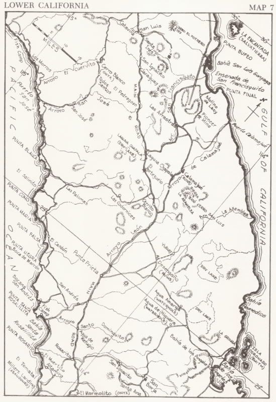
One of the maps from the Lower California Guidebook:
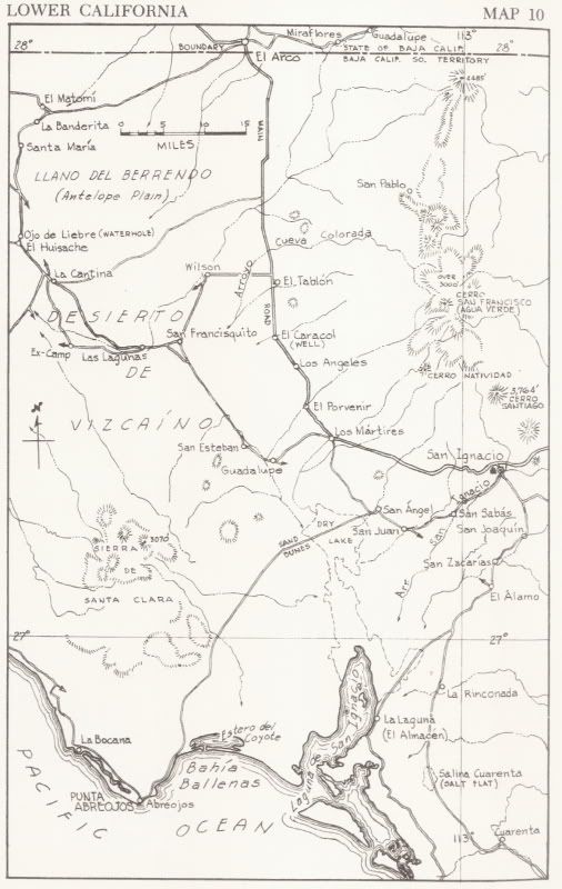
Here are the 'new' (since 1962) major roads/ highways added:
See the newest set of images showing the old road location, starting here: http://forums.bajanomad.com/viewthread.php?tid=48770
[Edited on 10-30-2010 by David K]
|
|
|
Mulegena
Super Nomad
Posts: 2412
Registered: 11-7-2006
Member Is Offline
|
|
Thanks So Much!!!
Oh, this is great-- a bit of not-so-distant but oh, so different past... reminds me of my mother recalling her childhood summer her parents took the
children on a visit of the Alta California Missions. That sort of travel was no less a memorable adventure for a child in the 1920's. I envy you your
childhood memories and appreciate how the experience fostered your love of the spirit of nature that still resides today in modern Baja California.
|
|
|
David K
Honored Nomad
Posts: 65595
Registered: 8-30-2002
Location: San Diego County
Member Is Online
Mood: Have Baja Fever
|
|
| Quote: | Originally posted by Mulegena
Oh, this is great-- a bit of not-so-distant but oh, so different past... reminds me of my mother recalling her childhood summer her parents took the
children on a visit of the Alta California Missions. That sort of travel was no less a memorable adventure for a child in the 1920's. I envy you your
childhood memories and appreciate how the experience fostered your love of the spirit of nature that still resides today in modern Baja California.
|
You are very welcome!!!
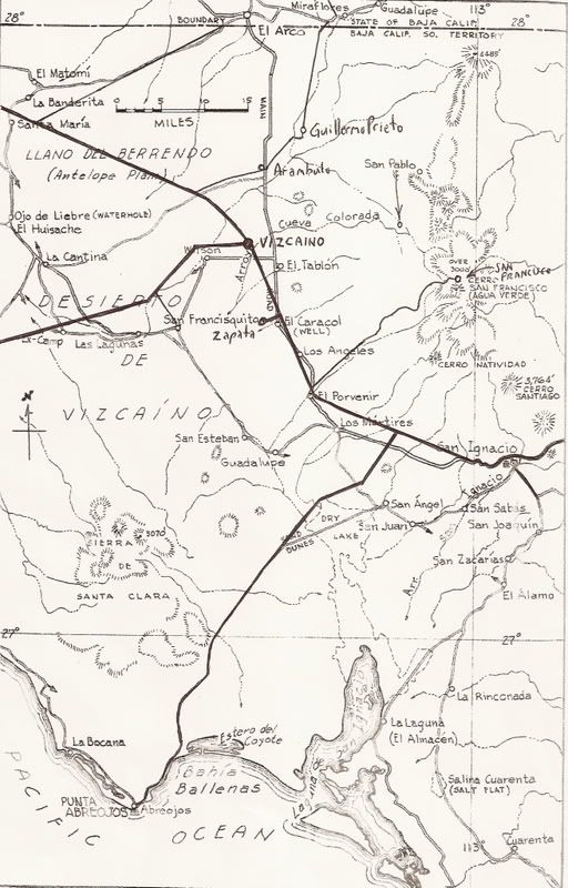
I added a second map below the first, where I added the highways and graded roads that have been added since the 1960's.
Would you guys like to see the rest of central Baja, the same way?
|
|
|
surfer jim
Super Nomad
Posts: 1891
Registered: 8-29-2003
Location: high desert
Member Is Offline
|
|
What about the area between ENSENADA and El Rosario.....any info on that?
|
|
|
David K
Honored Nomad
Posts: 65595
Registered: 8-30-2002
Location: San Diego County
Member Is Online
Mood: Have Baja Fever
|
|
Sure Jim...
There was a 'highway' to near El Rosario (paved to near Colonet, graded dirt most of the rest) in the 1960's.
The map(s) were to visualize the article on finding the old Baja road.
It is between El Rosario and Villa Insurgentes where the 'new' road was built (About 1969 to December, 1973)
|
|
|
TMW
Select Nomad
Posts: 10659
Registered: 9-1-2003
Location: Bakersfield, CA
Member Is Offline
|
|
When you take the turn off road (hwy5) at Chapala heading to Gonzaga as you reach the east side of the dry lake there are some trees , a well and
concrete forms next to the road as I recall. Is that the original location of Rancho Chapala?
|
|
|
David K
Honored Nomad
Posts: 65595
Registered: 8-30-2002
Location: San Diego County
Member Is Online
Mood: Have Baja Fever
|
|
| Quote: | Originally posted by TW
When you take the turn off road (hwy5) at Chapala heading to Gonzaga as you reach the east side of the dry lake there are some trees , a well and
concrete forms next to the road as I recall. Is that the original location of Rancho Chapala? |
YES! Arturo Grosso, brother of 'Mama' Anita Espinoza established that ranch... an important stop in the old pre-pavement Baja days!
Approaching Rancho Chapala from the north (see it in the distance), the worst part of the peninsula drive was this dust bowl of silt you had to drive
through!:
1965:

Grosso's ranch house:
1955:

The best part of the peninsula drive was the dry lake bed.. after traveling at 15 mph for hundreds of miles, you could open it up and blow off some of
the dust!
1956:

The above photos from Howard Gulick, The Lower California Guidebook author. All the photos: http://orpheus.ucsd.edu/speccoll/baja/gulick/ (this link is also on my web page)
|
|
|
David K
Honored Nomad
Posts: 65595
Registered: 8-30-2002
Location: San Diego County
Member Is Online
Mood: Have Baja Fever
|
|
Old Road Map
New since 1960's roads added (paved: heavy lines, graded: light lines)
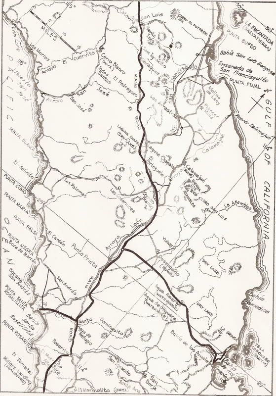
[Edited on 2-21-2009 by David K]
|
|
|
David K
Honored Nomad
Posts: 65595
Registered: 8-30-2002
Location: San Diego County
Member Is Online
Mood: Have Baja Fever
|
|
Here's the main Baja highway in the 1960's at Bahia Concepcion... at high tide!
Photo from Mike McMahan
Here is perhaps the same place 40 years later... now used to get to a beach camp...

|
|
|
sanquintinsince73
Super Nomad
Posts: 1502
Registered: 6-8-2010
Location: Los Angeles, CA
Member Is Offline
|
|
Thanks David K!!
|
|
|
Bajatripper
Ultra Nomad
Posts: 3152
Registered: 3-20-2010
Member Is Offline
|
|
| Quote: | Originally posted by David K
It is between El Rosario and Villa Insurgentes where the 'new' road was built (About 1969 to December, 1973) |
I recall that the graded highway ended in the San Quintin Valley. The road south of the town of San Quintin on to El Rosario was comprised of multiple
deep tracks filled with that fine-powdered silt that got into everything--much like the old road at the north end of Laguna Chapala also was at that
time. The couple of deep arroyos that had to be crossed along that alluvial plain were also impressive. And, of course, the final descent into El
Rosario was most definitely "Old Road."
Perhaps it left a deep impression on me since we once traveled the pre-paved road in a '65 Mustang--not exactly a preferred method for touring Baja in
those days.
In those days, El Rosario had the distinction of being where "civilization" (and mail service) ended until one crossed into BCS.
Great photos of the Old Road along Conception Bay. I remember well where that stretch was (and still is, since it is used for access to El Coyote
beach). Remember the little white cabin with the red roof that was next to the palms, just beyond this section of road? I remember seeing that cabin
on the cover a guide book, you probably know which book that would be, David.
I've always had a secret desire to own one of those old Willis 4WD, just because that is what Howard Gulick had. It would have had to have been much
more comfortable than that '44 Dodge Power Wagon/Army Ambulance we traveled about in most of the time--the anti-shrapnel "insulation" in the walls
made the interior like an oven in the summers. I can remember the streams of mud that flowed down our faces and necks as our sweat conbined with the
road dust we lived in.
Aaaahhh, great memories, David, thanks.
[Edited on 9-28-2010 by Bajatripper]
|
|
|
Cypress
Elite Nomad
Posts: 7641
Registered: 3-12-2006
Location: on the bayou
Member Is Offline
Mood: undecided
|
|
David K. Thanks for the information.
|
|
|
David K
Honored Nomad
Posts: 65595
Registered: 8-30-2002
Location: San Diego County
Member Is Online
Mood: Have Baja Fever
|
|
El gusto es mio!
Steve, please write some stories of your travels in the old pre-pavement days, when you can... I have done a few, but I was pretty young. Good thing
my memory holds on to Baja so well!
We traveled the length of Baja in the first time in 1966, in a Jeep Wagoneer... 2 weeks to get to Cabo San Lucas, then came back to La Paz via Todos
Santos to take the new ferry to Mazatlan to drive on pavement back home. Gerhard & Gulick's book was the 'Baja Bible'... If there was a fork in
the road but not in the book, it was just a detour and rejoined the the other branch shortly ahead... we would learn.
Pavement ended before Colonet and didn't begin again until some hundred miles north of La Paz. South of La Paz pavement ended in 10 miles, and the new
graded road went as far as San Bartolo getting near Los Barriles. The rest of the road to Cabo was just a single track 'Jeep trail'! In 1970, a paved
road reached Cabo from La Paz, and in two more years reached north to Santa Rosalia... a fantastic rate of construction. The rate in the northern stae
was far slower... in 1972, the pavement only reached San Quintin valley!
1973 is when the pace really went ballistic... From Km. 0 on the south side of San Quintin (Lazaro Card##es) to Santa Rosalia... all in one year...
finished in November and opened officially on December 1, 1973 at the base of the giant eagle monument at the border between the state of Baja
Califronia and the territory of Baja California Sur.
|
|
|
bent-rim
Nomad
Posts: 294
Registered: 7-31-2007
Location: Marin County
Member Is Offline
Mood: Living la vida mota
|
|
I printed all of the blue rectangles on the Gerhard and Gulick maps from 1962 on David's website and taped them together. It makes for an impressive
map about 6' long. Again, thank you David for all of your efforts regarding Baja.
Edited due to misspelling
[Edited on 9-23-2010 by bent-rim]
|
|
|
vacaenbaja
Senior Nomad
Posts: 644
Registered: 4-4-2006
Member Is Offline
|
|
That Old Baja road
David,
I really enjoyed reading the book The long walk to Mulege
I have had some difficulty however attempting to retrace
the route taken by the travelers. The name places between
Chapala and San Ignacio are difficult to locate on my baja
Atlas. Perhaps certain watering holes and water ways were
known by other names E. G. agua Leon, San Julio Wash.
Any ideas on what you think was their route and or the name of the various ranches they stopped at?
[Edited on 9-23-2010 by vacaenbaja]
|
|
|
David K
Honored Nomad
Posts: 65595
Registered: 8-30-2002
Location: San Diego County
Member Is Online
Mood: Have Baja Fever
|
|
| Quote: | Originally posted by vacaenbaja
David,
I really enjoyed reading the book The long walk to Mulege
I have had some difficulty however attempting to retrace
the route taken by the travelers. The name places between
Chapala and San Ignacio are difficult to locate on my baja
Atlas. Perhaps certain watering holes and water ways were
known by other names E. G. agua Leon, San Julio Wash.
Any ideas on what you think was their route and or the name of the various ranches they stopped at?
[Edited on 9-23-2010 by vacaenbaja] |
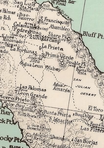
Yah, I like that book a lot! When they did their walk (in 1921), automobiles were pretty rare and any roads went between active mine camps... Agua
Leon and Leon Grande are both west and north of Punta Prieta... The main road avoided them as it went between Laguna Chapala and Punta Prieta. Agua
Leon was a spring and Leon Grande was the mine camp... both named in the book.
See them on this 1930 map:
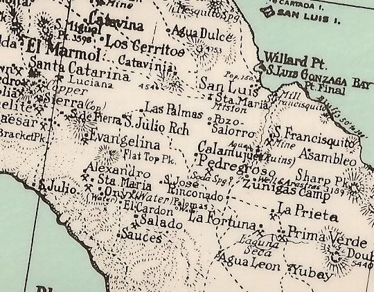
On this 1941 auto. map of Baja, you can see Leon Grande and San Julio (on the coast, west of Chapala):
On the 1930 map there is a San Julio Ranch south-west of Catavña and a San Julio on the coast. The ranch is also near the Las Palmas mentioned in the
book!
|
|
|
David K
Honored Nomad
Posts: 65595
Registered: 8-30-2002
Location: San Diego County
Member Is Online
Mood: Have Baja Fever
|
|
| Quote: | Originally posted by bent-rim
I printed all of the blue rectangles on the Gerhard and Gulick maps from 1962 on David's website and taped them together. It makes for an impressive
map about 6' long. Again, thank you David for all of your efforts regarding Baja.
Edited due to misspelling
[Edited on 9-23-2010 by bent-rim] |
LOL, I have done the very same!
|
|
|
DavidE
Ultra Nomad
Posts: 3814
Registered: 12-1-2003
Location: Baja California México
Member Is Offline
Mood: 'At home we demand facts and get them. In Mexico one subsists on rumor and never demands anything.' Charles Flandrau,
|
|
Ya otta seen la cuesta de lucifer before it was citified. And the dust on Chapala. Could have sworn that damned dust got inside factory bottled coca
cola.
Used to be I could sneak off of the asphalt and be right back on the original track. But that was maybe twenty years ago or more and I guess it's all
fading into the mist by now.
|
|
|
David K
Honored Nomad
Posts: 65595
Registered: 8-30-2002
Location: San Diego County
Member Is Online
Mood: Have Baja Fever
|
|
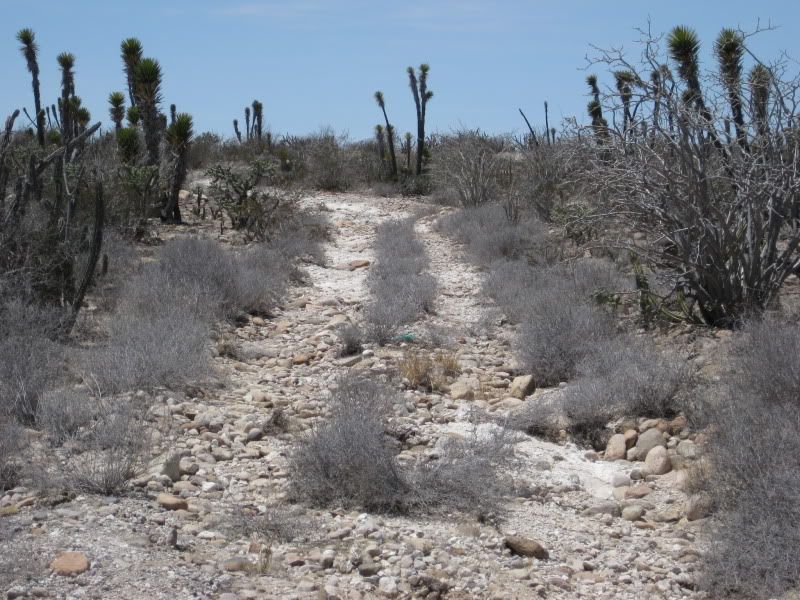
Nature and erosion are fading away the old road in the places it isn't still used. Here's a photo I took of it last summer, south of El Arco/ north of
San Ignacio:
|
|
|
Skeet/Loreto
Ultra Nomad
Posts: 4709
Registered: 9-2-2003
Member Is Offline
|
|
Thanks for some good Memories David. I got out my old maps and checked you along the way.
On the Weekend the Road Opened My Son and I had been in Loreto after coming across the Ferry. My wife and Daughter with relatives strated up the new
road.
Todd and I in my Cessna 170 b got stuck in Santa Rosalilla and landed at the old City Airport. The Winds being so strong two guys held down the
Wingtips when I landed and Tasied in to Tie Down.
Nest moring took off and landed in the Stree in Guerreo Nego to get Fuel. Had not luck so took off headed North, As I approached Lake Chapala i knew I
was very low on Fuel so opted to land at the Lake chapala Strip and tied up next to the Ranch House,
The owners had moved over to the New Road into their new Rancho Chapala Home.
We Hiked to the road and caught a ride to Sta Innes where Senora Josephine got me some Fuel and two guys in a Pick up who took me back down and filled
my Tanks. All for $10 !!!!
Great Times
Skeet
|
|
|
| Pages:
1
2 |


