| Pages:
1
2 |
David K
Honored Nomad

Posts: 65595
Registered: 8-30-2002
Location: San Diego County
Member Is Offline
Mood: Have Baja Fever
|
|
The Old Road and Hwy. 1: (Part 1 El Rosario-Cataviña)
Starting a fresh thread with new satellite images showing the relationship between the original Baja transpeninsular road and Highway 1, completed in
1973.
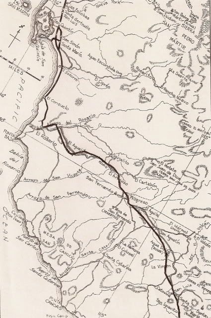
First off, the best map of the old road was drawn by Howard Gulick for the 1962 Lower California Guidebook. Here is the map of this first area of
discussion (El Rosario to Cataviña).
In 1962, there was no Cataviña other than an abandoned adobe, now behind the Desert Inn hotel, in the new town of Cataviña (which began after the
highway was finished, as a gas station, parador or rest area and snack bar, an RV park and then it was the El Presidente hotel).
Here is Howard's map with the new highway drawn over:
Next, we have Cliff Cross' and his cool bird's-eye view maps drawn for his 1970 Baja guide.
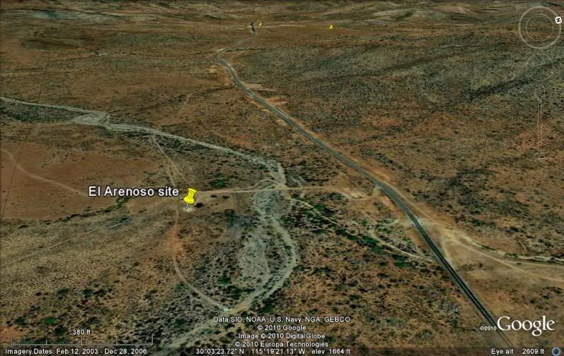
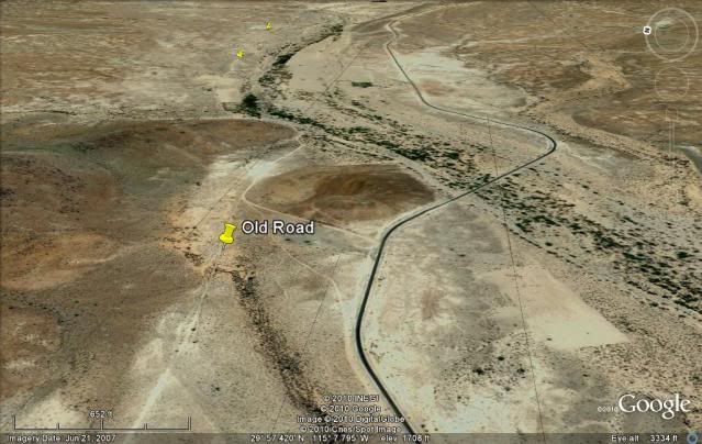
We will start with El Rosario to El Arenoso... El Aguajito is between the two. The highlighter blue line is where the highway runs in relation to
Cliff's placement of the old main road... then below, we will look at the satellite images to see the real relationship!
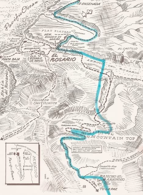
That is the El Rosario River Valley in the distance.
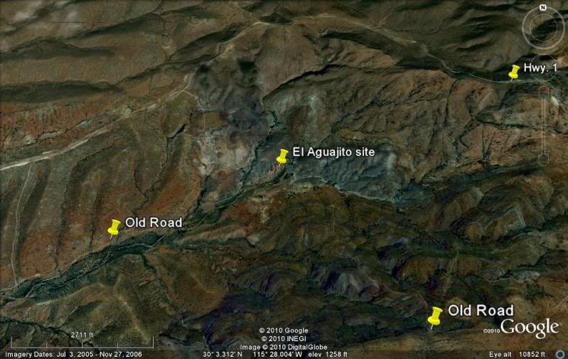
A four mile long, rocky grade began at El Aguajito and many considered it one of the toughest sections of the old road.
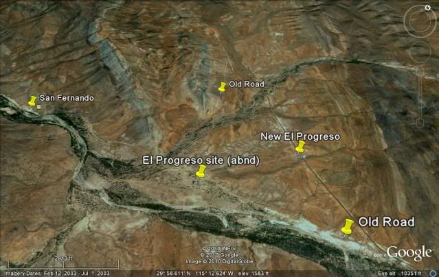
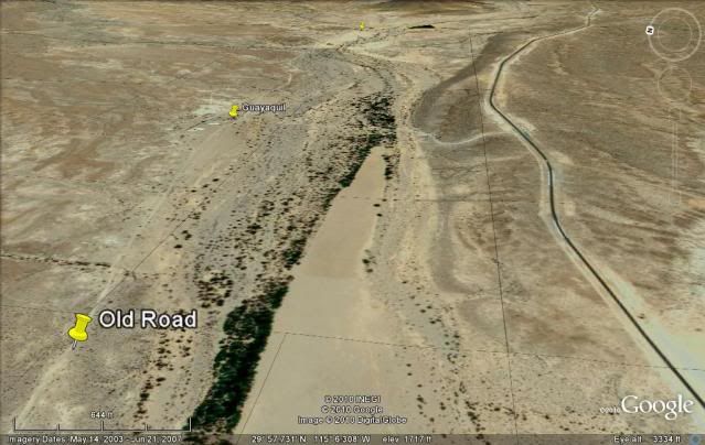
The next Cliff Cross map covers the section from El Arenoso to La Virgen and includes El Progreso (moved to Hwy. 1), Penjamo, El Aguila, San Agustin,
Tres Enriques, Sonora (moved to Hwy. 1), and Agua Dulce (historic spring on the Camino Real)... (Cliff placed the spring on the wrong side of the main
road, but the ranch ruins are correct)...
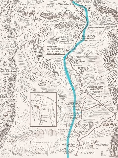
A sign for Rancho Penjamo is on Hwy. 1 right before the highway turns right and crosses the arroyo (Arroyo San Fernando).
Guayaquil didn't exist before 1970, but is located between Panjamo and El Aguila...
When Highway 1 was built, a gas station, trailer park and highway maintenance facility was built and named 'San Agustin' after the old ranch, located
out-of-sight, over a hill from the highway...
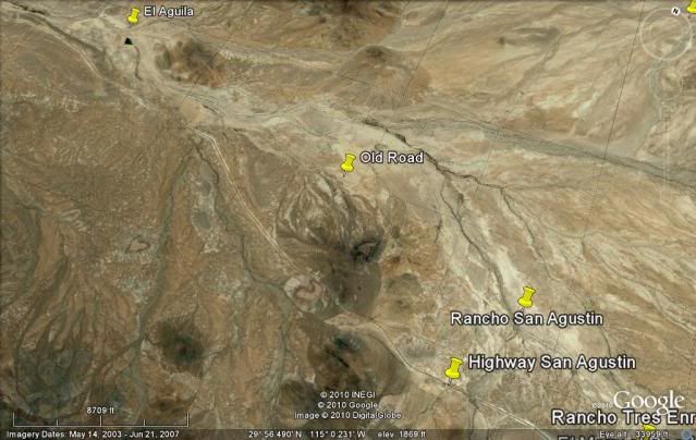
Cafe Sonora is just past the road to El Marmol, originally the Rancho Sonora was on the old road...
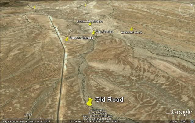
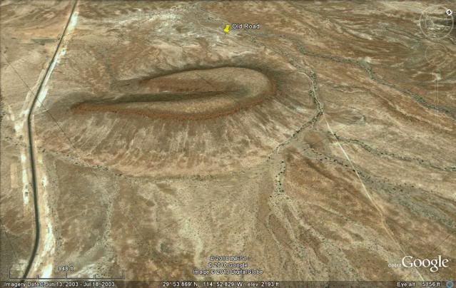
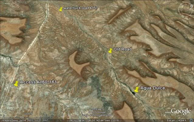
Very near Km. 157, a water truck supply road was made in 1973 to the old road so water could be taken from the historic spring of Agua Dulce.
The spring was bulldozed and the original date palm destroyed. Water was needed to build the highway.
32 years later I returned to find the bulldozed grading at the spring still visible, but vegetation has hidden the other scars and a blue palm now
grows there.
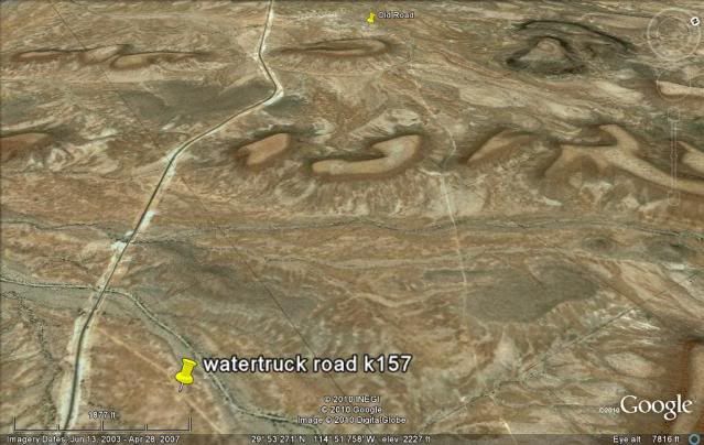
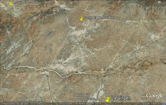
The water truck road is badly washed out now. A better way to get to Agua Dulce and the old road is at Km. 160-161. Thanks go to Neal Johns for
finding this road!

Agua Dulce in 2005
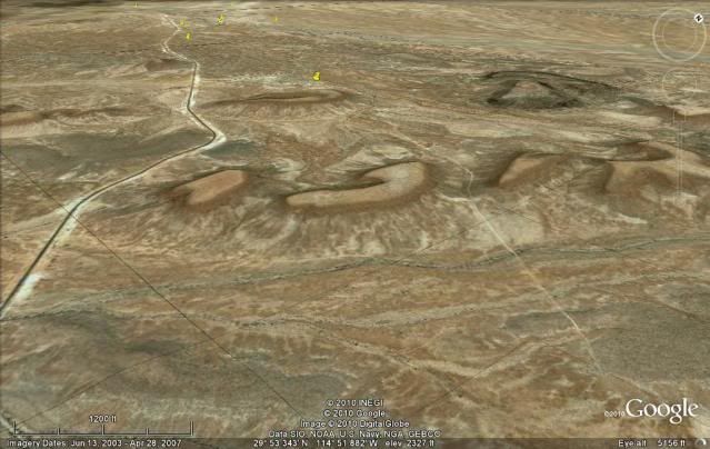
OLD MAIN ROAD:

Looking south on the old road... my truck is on the Agua Dulce access road from Km. 160-161.
Just south of Agua Dulce, the old southern road from El Marmol joins the old main road... then the La Virgen shrine and the site of a small business
that serviced travelers, before the highway was built.
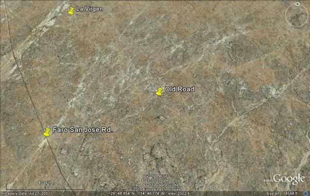
The road is to the Pacific coast at San Jose lighthouse (faro).
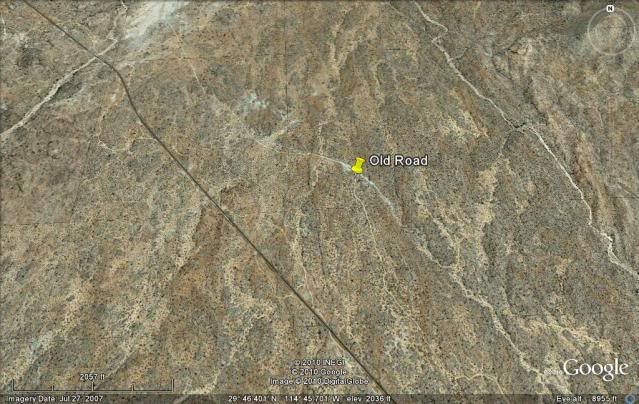
The old main road joins Hwy. 1 just north of the rock art cave parking turnoff... which is just before the first Cataviña stream crossing.
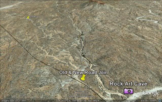
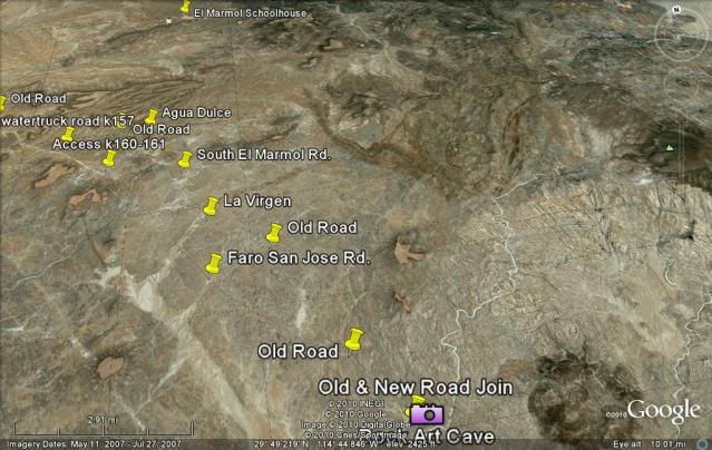
The Cataviña/ Santa Ynez area...
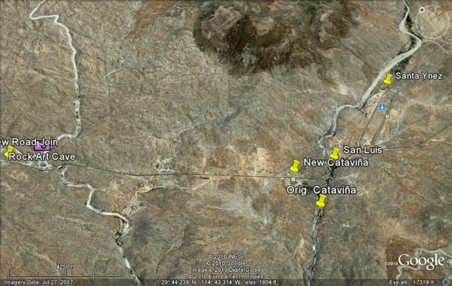
This is a high view... the Santa Ynez paved airport is on the right.. and the roack art cave is on the left.. the black line is Hwy. 1.
Hope a few of you found this interesting and will try and drive some of the old Baja road, while it is still there! A really good section is from Agua
Dulce to Cataviña.
You can easily get on it from the El Marmol road (at the orig. Rancho Sonora site) and go to Agua Dulce, however, it is deeply rutted with a high
rocky crown... So, I recommend extra high ground clearance for the section north of Agua Dulce.
Other sections are shorter, but at least you can have a look now that you know where it is. Many of the dirt roads one sees along Hwy. 1, that you
might presume is the old road, are actually detour or access roads made during the construction of Hwy. 1. A really good example of this error often
published, is south of Loreto along the steep grade above Ligui. The old main road did not go through Loreto, and the only road below Loreto in the
60's dead-ended at Ligui.
The old main road went through San Jose Comondu, from just south of Bahia Concepcion (or a slightly longer option to La Paz was through La Purisima)
and on to Villa Constitucion (or El Crucero) as Cd. Constitucion was called then.
It takes a bit of work to put this all up, so let me know if you like it and that will encourage me to continue on south with the old and the
new!!  
[Edited on 3-20-2019 by David K]
|
|
|
racheldarlin
Junior Nomad
Posts: 69
Registered: 9-30-2010
Member Is Offline
|
|
Fantastic post. Thank you for sharing and please keep them coming. I share your obvious passion for Baja history and have used information from your
web site many times for planning trips. Will these post become part of your site?
|
|
|
BooJumMan
Senior Nomad
Posts: 945
Registered: 8-11-2007
Location: San Diego
Member Is Offline
|
|
Nice job, thanks!
|
|
|
captkw
Ultra Nomad
Posts: 3850
Registered: 10-19-2010
Location: el charro b.c.s.
Member Is Offline
Mood: new dog/missing the old 1
|
|
HOLA, cool..I love stuff like this,going back next week, for the winter
....adios
|
|
|
mcfez
Elite Nomad
Posts: 8678
Registered: 12-2-2009
Location: aka BN yankeeirishman
Member Is Offline
|
|
Agua Dulce in 2005 Picture: Come on DavidK.....this is really a busted drip line scene on one of your jobsites 
Now seriously: The second picture shows the road IN arroyo El Rosario. How did the large transport trucks with their heavy loads travel thru that?
Sand all it seems...
[Edited on 10-30-2010 by mcfez]
Old people are like the old cars, made of some tough stuff. May show a little rust, but good as gold on the inside.
|
|
|
Bob H
Elite Nomad
Posts: 5867
Registered: 8-19-2003
Location: San Diego
Member Is Offline
|
|
Very nice WORK David! Love it. It's amazing to me that the old road still exists in many places.
Bob H
|
|
|
David K
Honored Nomad
Posts: 65595
Registered: 8-30-2002
Location: San Diego County
Member Is Offline
Mood: Have Baja Fever
|
|
| Quote: | Originally posted by mcfez
Agua Dulce in 2005 Picture: Come on DavidK.....this is really a busted drip line scene on one of your jobsites
Now seriously: The second picture shows the road IN arroyo El Rosario. How did the large transport trucks with their heavy loads travel thru that?
Sand all it seems...
[Edited on 10-30-2010 by mcfez] |
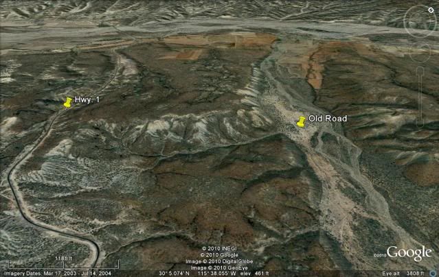
The first satellite image, you mean?
That arroyo containing the old road is NOT Arroyo El Rosario... Arroyo El Rosario is in the background running from right to left (see Hwy. 1 bridge
crossing it?).
The old road left El Rosario as the highway does today, but crossed to the other side west of where the Hwy. 1 bridge crosses... then continued on
going east on the south bank before reacing the side arroyo where it turns south into it (across for the cliff 'El Castillo')... See Gulick's and
Cross' maps.
There was many sandy sections, rocky sections, sections you would think needed 4WD... The trucks that brought supplies and gasoline down Baja where
quite amazing... from flatbed panel side to something like Mr. Haney's truck from Green Acres selling, buying, transporting everything from live
turtles to toothbrushes! They were called Fayuqeros... and got their trucks where ever business could be done.
|
|
|
David K
Honored Nomad
Posts: 65595
Registered: 8-30-2002
Location: San Diego County
Member Is Offline
Mood: Have Baja Fever
|
|
| Quote: | Originally posted by racheldarlin
Fantastic post. Thank you for sharing and please keep them coming. I share your obvious passion for Baja history and have used information from your
web site many times for planning trips. Will these post become part of your site? |
Glad you enjoyed enough to make this your first post on Nomad... WELCOME!!
I will continue, so stay tuned!
|
|
|
john
Junior Nomad
Posts: 73
Registered: 10-14-2004
Member Is Offline
|
|
I was just checking out some of those trails just last week on google earth. we will be out there this week for about 5 days just checking out all the
different trails
|
|
|
David K
Honored Nomad
Posts: 65595
Registered: 8-30-2002
Location: San Diego County
Member Is Offline
Mood: Have Baja Fever
|
|
Okay, Part 2 is done (Cataviña to Punta Prieta): http://forums.bajanomad.com/viewthread.php?tid=48791
|
|
|
Neal Johns
Super Nomad
Posts: 1687
Registered: 10-31-2002
Location: Lytle Creek, CA
Member Is Offline
Mood: In love!
|
|
DK, My favorite area! Thanks!
Also thanks for telling me where the real Agua Dulce was a few years ago!
You older guys are handy to have around. 
My motto:
Never let a Dragon pass by without pulling its tail!
|
|
|
Phil S
Super Nomad
Posts: 1205
Registered: 10-28-2003
Member Is Offline
Mood: After 34 years. Still in love w/ my wife
|
|
David. Thanks for the 'history' trip. Always looking forward to reading your'stuff'.
|
|
|
Mexitron
Ultra Nomad
Posts: 3397
Registered: 9-21-2003
Location: Fort Worth, Texas
Member Is Offline
Mood: Happy!
|
|
I've done the Agua Dulce to Catavina portion---lot of history there. Thanks for reinvigorating the thread, missed it the first time around.
|
|
|
bacquito
Super Nomad
Posts: 1615
Registered: 3-6-2007
Member Is Offline
Mood: jubilado
|
|
alot of good work on your part, thanks.
bacquito
|
|
|
David K
Honored Nomad
Posts: 65595
Registered: 8-30-2002
Location: San Diego County
Member Is Offline
Mood: Have Baja Fever
|
|
Your welcome... and enjoy the links to the other parts of it!
Part 2 (Cataviña to Punta Prieta): http://forums.bajanomad.com/viewthread.php?tid=48791
|
|
|
thebajarunner
Ultra Nomad
Posts: 3755
Registered: 9-8-2003
Location: Arizona....."Free at last from crumbling Cali
Member Is Offline
Mood: muy amable
|
|
I remember my first trip over that road- headed to El Arco to pit my friends for the 1971 Mexican 1000.(It was never called the "Baja" 1000 until
SCORE came along)
We drove out of El Rosario after dark (lobster burritos at Mama's) and soon found ourselves at the beginning of the mountain crossing and roads headed
in every direction.
I waved down a trucker and asked, in my really bad Spanish, "Which road goes to Santa Ynez (we never called it Catavina)"
He sort of grinned and said, as best I could translate, "All roads go to Santa Ynez"
So, we just picked one and wound up, around and over that nasty grade, in the dark, first time in off-road Baja.
It was a true adventure, one that still resonates, even after so many thousands of miles racing, pre-running and just prowling around.
|
|
|
David K
Honored Nomad
Posts: 65595
Registered: 8-30-2002
Location: San Diego County
Member Is Offline
Mood: Have Baja Fever
|
|
Yes, if there was a fork in the road and it wasn't mentioned in Gerhard & Gulick (Lower California Guidebook), then it was just a detour and would
re-join up ahead. Detour roads were made if a boojum tree fell across the road, or a truck was broken down a long time, or to get around a low spot
after a rain.
The last Mexican 1000 was 1972 (Mexicali to La Paz via San Quintin). Then the Mexican's kicked NORRA out thinking they could do better with their Baja
Sports Committee Baja Mil (1000)... they didn't... So, Mickey Thompson and his new SCORE organization was invited in in 1974 to do a new race that
July (about 400 miles long), The Baja Internacional.
It was a huge success, but there wasn't enough time to organize a 1000 race that year, so '74 was the only year without a '1000'. The first SCORE Baja
1000 was in 1975 and for the first time was a loop race in the northern state only, starting and ending in Ensenada.
The first SCORE 1000 to finish in La Paz was 1979. Since then, every 3-4 years or so, they run to La Paz and the other years they stay in Baja norte.
Sometimes starting in Mexicali or elsewhere, over Ensenada.
I was lucky to have been at the '73 BSC Mil, the '74 Internacional, the '75 1000, and was a co-driver in the '79 1000!
[Edited on 9-14-2012 by David K]
|
|
|
vacaenbaja
Senior Nomad
Posts: 644
Registered: 4-4-2006
Member Is Offline
|
|
As a side note back in the late 70's I drove off the highway down to the settlement of Guayaquil out of curiosity.
Guayaquil is a port city in Ecuador and the name comes from
that region. I asked an elderly gentlemen in the towns main
building how did they come to name this place Guayaquil.
His response was someone saw it in a newspaper and they
all thought that it had a nice ring to it. Do not know if that is true, but it is what I was told.
|
|
|
David K
Honored Nomad
Posts: 65595
Registered: 8-30-2002
Location: San Diego County
Member Is Offline
Mood: Have Baja Fever
|
|
Awesome story! I read it got started when El Marmol closed its onyx mine and the residents relocated.
|
|
|
David K
Honored Nomad
Posts: 65595
Registered: 8-30-2002
Location: San Diego County
Member Is Offline
Mood: Have Baja Fever
|
|
Bump... if anyone out there would like more help in finding the old pre-1973 main Baja transpenisular road, just shout...
|
|
|
| Pages:
1
2 |


