| Pages:
1
2 |
David K
Honored Nomad

Posts: 64568
Registered: 8-30-2002
Location: San Diego County
Member Is Offline
Mood: Have Baja Fever
|
|
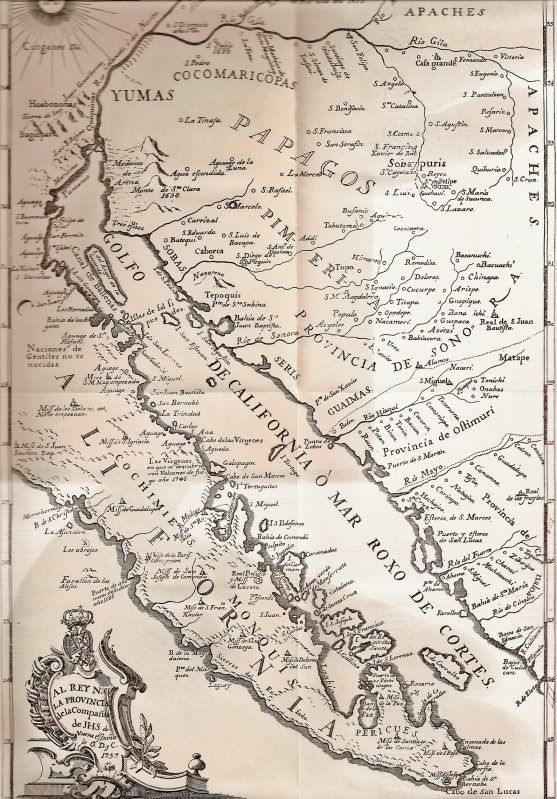
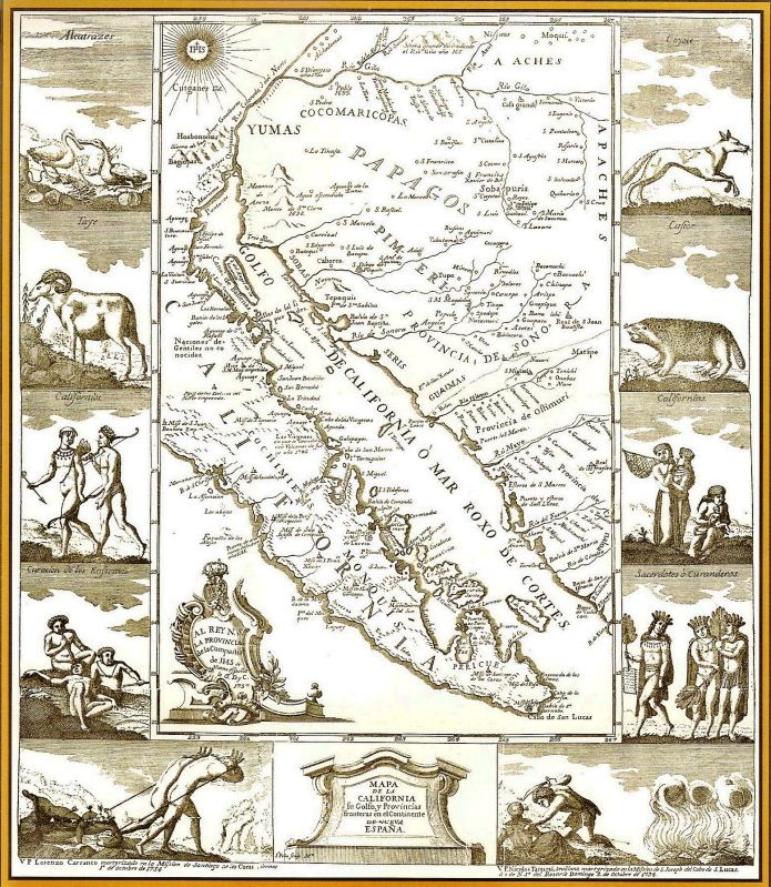
1757 Jesuit Map, a closer look.
The map made from information gatherd on the peninsula about 10 years earlier and drawn by Venegas who never set foot on the peninsula.
A few errors and three mission labled as 'started' that led to lost mission stories.
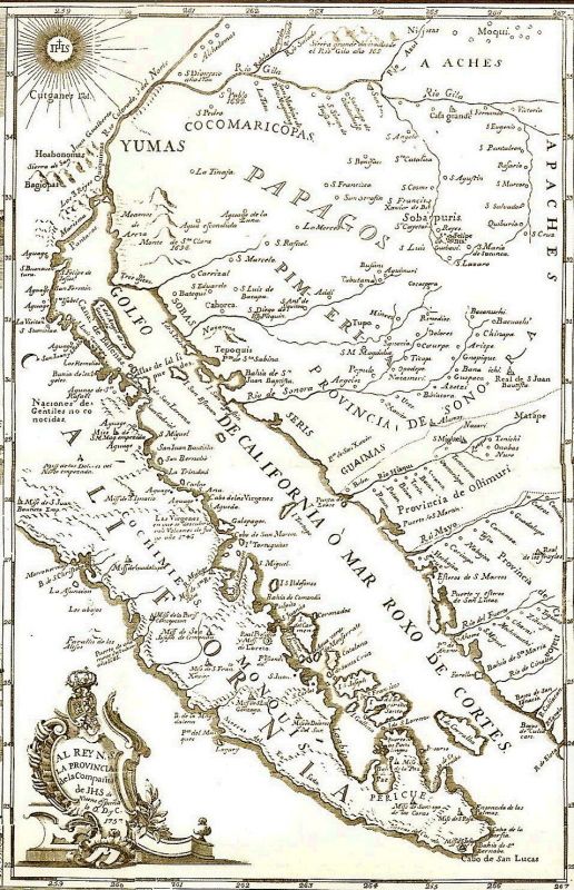
South half:

North half:

Zoom in south to north:
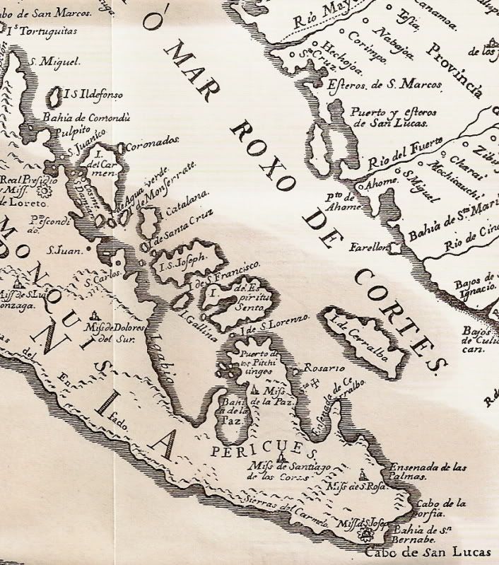
Shown are the missions of Dolores del Sur (at the La Pasion site), La Paz (which was moved to Todos Santos in 1748), Santiago, Santa Rosa (shown on
the wrong side of Baja because Venegas confused it with the visita of San Jose named Santa Rosa), and San Jose (del Cabo).
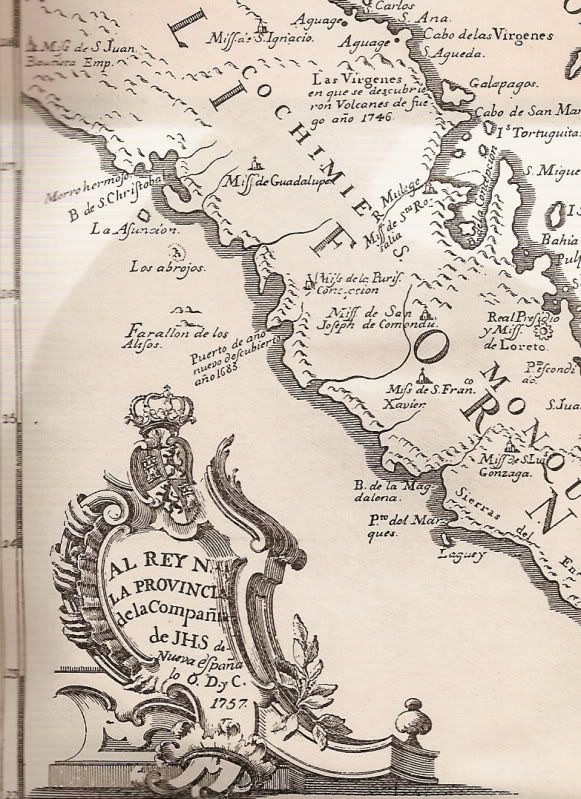
In the top left corner of the above zoom-in map note the mission of San Juan Bautista 'started' (Emp.)... This is the lost Santa Clara mission near
Punta Abreojos. Also note the 1746 eruption of the Tres Virgenes volcano listed on the map. In 1747, San Ignacio was the furthest north mission. See
also the missions of Guadalupe, Santa Rosalia de Mulege, La Purisima Concepcion, San Jose de Comondu, Loerto, San Francisco Javier, San Luis Gonzaga.
Dolores del Norte was an early name for the mission that would become Santa Gertrudis
Northeast of there, closer to Bahia de los Angeles is the 'started' mission of Santa Maria Magdalena (which was never established, but we checked out
some ruins discovered in 1966 that some believe could have been that 'started' mission! http://vivabaja.com/109
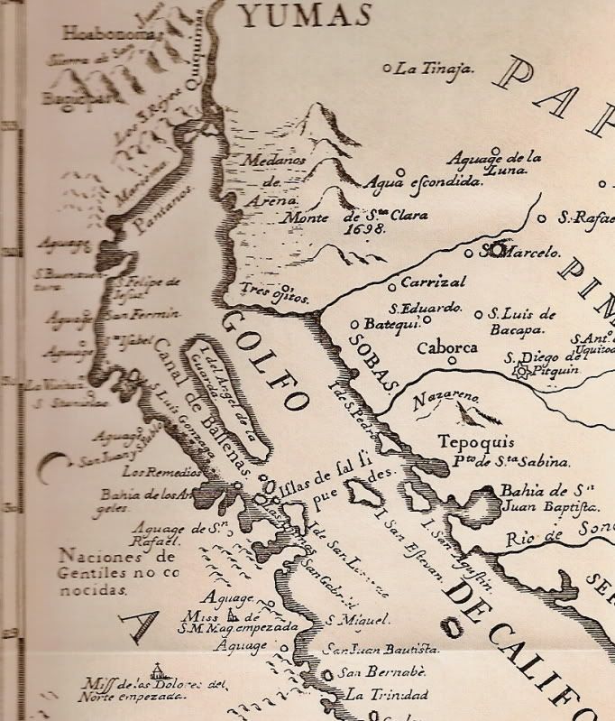
Placenames born on this map include San Felipe, Punta San Fermin, Bahia San Luis Gonzaga, Punta Remedios, Bahia de los Angeles, Bahia San Rafael...
[Edited on 2-29-2012 by David K]
|
|
|
Vince
Nomad
Posts: 445
Registered: 10-17-2006
Location: Coronado
Member Is Offline
|
|
A lot of great history packed into that map when you study it. I didn't realize the town of Caborca is so old. Thanks, David.
|
|
|
David K
Honored Nomad
Posts: 64568
Registered: 8-30-2002
Location: San Diego County
Member Is Offline
Mood: Have Baja Fever
|
|
Yah, Mexico is old... 'Old Mexico', they used to say!
You will see a lot of the word 'Aguage' along the coast north of Mulege, that indicates a water source... important to anyone and specially sailors.
One aguage the Jesuits named 'Santa Isabel' between Punta San Fermin (near today's Puertecitos) and San Luis Gonzaga is what led lost mission hunters
to seek the lost mission of Santa Isabel in this region!
We Nomads did, last years! http://forums.bajanomad.com/viewthread.php?tid=52696
|
|
|
vandenberg
Elite Nomad
Posts: 5118
Registered: 6-21-2005
Location: Nopolo
Member Is Offline
Mood: mellow
|
|
Thanks DK.
|
|
|
David K
Honored Nomad
Posts: 64568
Registered: 8-30-2002
Location: San Diego County
Member Is Offline
Mood: Have Baja Fever
|
|
Maps are a window 'back in time'... Any area of Baja you would like to see on old maps, just let me know and if I have it, I will share it!
|
|
|
cjesme
Nomad
Posts: 212
Registered: 3-11-2009
Member Is Offline
|
|
Amazing maps! Just found a name for my upcoming foul...COCHIMIE!
Carlita and Esteban
|
|
|
bufeo
Senior Nomad
Posts: 793
Registered: 11-16-2003
Location: Santa Fe New Mexico
Member Is Offline
|
|
Love 'em, David K. Thanks for posting them. I love old maps, especially those of areas we frequent.
Allen R
|
|
|
David K
Honored Nomad
Posts: 64568
Registered: 8-30-2002
Location: San Diego County
Member Is Offline
Mood: Have Baja Fever
|
|
Missions shown on the map would seem to be showing Baja in 1747:
South to North:
San Jose (del Cabo)
Santa Rosa (Todos Santos), (shown on the wrong side of the sierra).
Santiago
La Paz (moved to Todos Santos in 1748)
Dolores del Sur (at La Pasion/ Chilla since 1741)
San Luis Gonzaga
San Francisco Javier
Loreto
San Jose de Comondu
La Purisima Concepcion
Santa Rosalia (de Mulege)
Guadalupe
San Ignacio
Then there are the three 'started' missions beyond San Ignacio in 1747 on the map:
San Juan Bautista (The Lost Santa Clara Mission)
Dolores del Norte (became Santa Gertrudis in 1751)
Santa Maria Magdalena (abandoned site near Bahia las Animas, discovered in 1966, revisited in 2009).
The mission at Ligui/ Malibat (San Juan Bautista) was abandoned in 1721 and is not shown.
|
|
|
Udo
Elite Nomad
Posts: 6335
Registered: 4-26-2008
Location: Black Hills, SD/Ensenada/San Felipe
Member Is Offline
Mood: TEQUILA!
|
|
I'm jealous of the time you have to find out all the HISTORY, DK!
Thank God for your work, or most of us would remain ignorant, and never know all this until after we die.
Udo
Youth is wasted on the young!
|
|
|
David K
Honored Nomad
Posts: 64568
Registered: 8-30-2002
Location: San Diego County
Member Is Offline
Mood: Have Baja Fever
|
|
I thank you Udo... but I do need some work/ employment or I become history!
|
|
|
El Vergel
Nomad
Posts: 197
Registered: 8-27-2003
Location: San Felipe - Puertecitos Rd., Km. 35 and Santa Mon
Member Is Offline
|
|
Baja
Very, very interesting, David! Thank you!
|
|
|
David K
Honored Nomad
Posts: 64568
Registered: 8-30-2002
Location: San Diego County
Member Is Offline
Mood: Have Baja Fever
|
|
De nada!
|
|
|
Blair
Junior Nomad
Posts: 63
Registered: 5-19-2010
Location: El Cajon Ca
Member Is Offline
Mood: Getting ready to go again
|
|
Thanks david, very interesting. I've shared your website with others outside of this group and it has generated a lot of discussion on future trips.
Our prior discussion on Guajademi led to our exploring that area last month and it was the highlight of our trip!
Blair in El Cajon
|
|
|
John M
Super Nomad
Posts: 1910
Registered: 9-3-2003
Location: California High Desert
Member Is Offline
|
|
Map
What is the source of this map David, from what publication?
|
|
|
David K
Honored Nomad
Posts: 64568
Registered: 8-30-2002
Location: San Diego County
Member Is Offline
Mood: Have Baja Fever
|
|
Engelhardt 1929
|
|
|
David K
Honored Nomad
Posts: 64568
Registered: 8-30-2002
Location: San Diego County
Member Is Offline
Mood: Have Baja Fever
|
|
Another source for the 1757 map...
The same Venegas map, but maybe a better copy for Nomad viewing?
Now with the missions on the map spelled out next to where they are on the map:
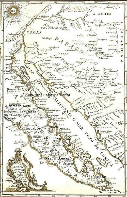
South to North: San José del Cabo, Santa Rosa de las Palmas, Santiago, Pilar de la Paz, Los Dolores (del Sur), San Luis Gonzaga, San Francisco Javier
(Xavier), Loreto, San José de Comondú, La Purísima Concepción, Santa Roaslía de Mulegé, Guadalupe (de Huasinapí), San Ignacio. Beyond San Ignacio and
shown as 'started': San Juan Bustista (Santa Clara lost mission), Dolores del Norte (became Santa Gertrudis), and Santa María Magdalena (another lost
mission, maybe was found?: http://vivabaja.com/109 )
A high resolution zoomable 1757 map is located at the bottom of our book's web site: http://oldmissions.com
|
|
|
BajaBruno
Super Nomad
Posts: 1035
Registered: 9-6-2006
Location: Back in CA
Member Is Offline
Mood: Happy
|
|
As an English Lit grad student many years ago I was studying symbolism in European maps and my professor directed me to the Getty Museum. They have
lots and lots of original obscure maps in their collections that can be examined. You might give them a call for an afternoon of digging through
their reserves if you want to look at the source documents.
Christopher Bruno, Elk Grove, CA.
|
|
|
David K
Honored Nomad
Posts: 64568
Registered: 8-30-2002
Location: San Diego County
Member Is Offline
Mood: Have Baja Fever
|
|
| Quote: | Originally posted by BajaBruno
As an English Lit grad student many years ago I was studying symbolism in European maps and my professor directed me to the Getty Museum. They have
lots and lots of original obscure maps in their collections that can be examined. You might give them a call for an afternoon of digging through
their reserves if you want to look at the source documents. |
That would be very cool indeed! I could take the Amtrak up from Oceanside! Thanks Chris...
|
|
|
durrelllrobert
Elite Nomad
Posts: 7393
Registered: 11-22-2007
Location: Punta Banda BC
Member Is Offline
Mood: thriving in Baja
|
|
Also note the 1746 eruption of the Tres Virgenes volcano listed on the map
Always wondered when this happened. By the way for us do-it-yoursefers you can further zoom in on the maps (or anything else) by holding down the trl
key and hitting the + sign.
Bob Durrell
|
|
|
Vince
Nomad
Posts: 445
Registered: 10-17-2006
Location: Coronado
Member Is Offline
|
|
I notice there is an island in the middle of Bahia Conception at the southern end. We often fish or dive on the reef locals call "roca frijole", in
the same place, maybe that was an island when the map was made. Also, San Marcos island was called Galapagos. All very interesting.
|
|
|
| Pages:
1
2 |


