| Pages:
1
2
3 |
Ken Cooke
Elite Nomad

Posts: 8923
Registered: 2-9-2004
Location: Riverside, CA
Member Is Offline
Mood: Its Pole Line Road time
|
|
| Quote: | Originally posted by Barry A.
------to be picky----- I question the designation "highway 5 N/S".. Surely that is not correct!?!?!?! Highway 5 would be much further east, it seems
to me?!?!?!?!
Barry |
Barry - I utilized GPS data to assemble the map. Trust me, I spent hours on this particular map.
|
|
|
Barry A.
Select Nomad
Posts: 10007
Registered: 11-30-2003
Location: Redding, Northern CA
Member Is Offline
Mood: optimistic
|
|
| Quote: | Originally posted by Ken Cooke
| Quote: | Originally posted by Barry A.
------to be picky----- I question the designation "highway 5 N/S".. Surely that is not correct!?!?!?! Highway 5 would be much further east, it seems
to me?!?!?!?!
Barry |
Barry - I utilized GPS data to assemble the map. Trust me, I spent hours on this particular map. |
Hmmmmmmmm, OK I trust you. Maps are sure fun. 
Barry
|
|
|
Taco de Baja
Super Nomad
Posts: 1913
Registered: 4-14-2004
Location: Behind the Orange Curtain, CA
Member Is Offline
Mood: Dreamin' of Baja
|
|
Out with the old, in with the new.
Fixed the anti-sway bay this weekend.
Came out to $140.00 plus my time of a little over an hour. I hate to think what the dealer would charge for this....
If anyone has a Toyota and you like to fix things yourself I can't recommend TRDParts4U enough. They are the parts department of Toyota of Dallas and carry genuine OEM Toyota parts at a great discount. The local
Stealership wanted $173 for the anti-sway bar; TRDParts4U had it for $103 with $17 shipping in less than a week. I have ordered several other parts in
the past , and they are always well below the local dealer even with the shipping.
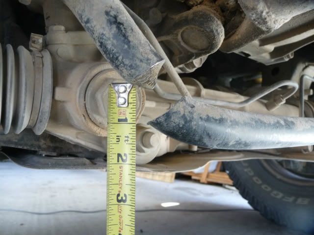
Before
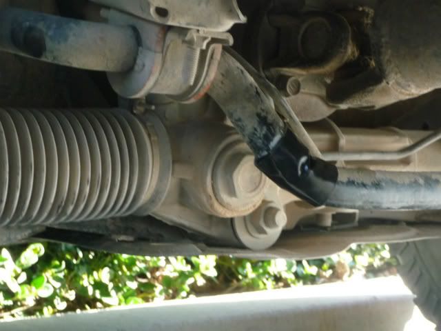
Temporary fix. Duct tape held up for a week of freeway driving 
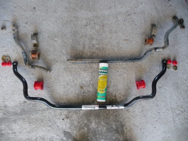
Out with the old, in with the new.
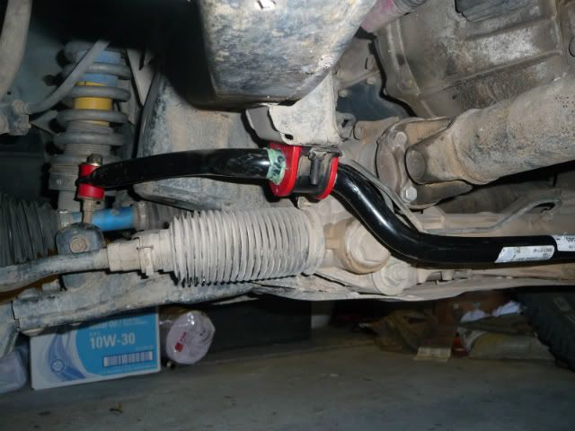
Fixed.
Also took the opportunity to replace the 12 year old polyurethane bushings with new ones at $20. Much improved ride now! Had I known, I'd have done
this years ago
Truth generally lies in the coordination of antagonistic opinions
-Herbert Spencer
|
|
|
Taco de Baja
Super Nomad
Posts: 1913
Registered: 4-14-2004
Location: Behind the Orange Curtain, CA
Member Is Offline
Mood: Dreamin' of Baja
|
|
| Quote: | Originally posted by Ken Cooke
|
Here's my GPS track of the same area. compared to Ken's map, almost the same scale .
Nice to be able to compare.

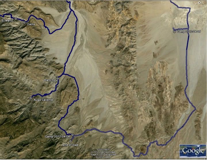
BTW Barry is correct, Hwy 5 is well to the east (approx 8-9 miles) in the mountains in the upper right of Ken's image.
Truth generally lies in the coordination of antagonistic opinions
-Herbert Spencer
|
|
|
Ken Cooke
Elite Nomad
Posts: 8923
Registered: 2-9-2004
Location: Riverside, CA
Member Is Offline
Mood: Its Pole Line Road time
|
|


|
|
|
David K
Honored Nomad
Posts: 64532
Registered: 8-30-2002
Location: San Diego County
Member Is Offline
Mood: Have Baja Fever
|
|
Nice repost of Neal Johns' article in Discover Baja!!!
|
|
|
Ken Cooke
Elite Nomad
Posts: 8923
Registered: 2-9-2004
Location: Riverside, CA
Member Is Offline
Mood: Its Pole Line Road time
|
|
| Quote: | Originally posted by David K
Nice repost of Neal Johns' article in Discover Baja!!! |
My favorite article from the Discover Baja Newsletter archives!
|
|
|
Mexitron
Ultra Nomad
Posts: 3397
Registered: 9-21-2003
Location: Fort Worth, Texas
Member Is Offline
Mood: Happy!
|
|
Thanks for posting the cool articles Ken. Until we found it had been named Basketball Hill we were calling it the "Drainpipe" and the "Laundry Chute"
.
Nice job on the truck Brooks!
|
|
|
Taco de Baja
Super Nomad
Posts: 1913
Registered: 4-14-2004
Location: Behind the Orange Curtain, CA
Member Is Offline
Mood: Dreamin' of Baja
|
|
Thanks for posting the articles Ken. Sounds like it was a little easier for us.
Although we did have to stop numerous times to move rocks, fill in gulleys,
trim branches, and relocate the road.....it does not seem as the road needed
quite as much maintenance.
As a side note, camped at the "lodge" you mention back in December. Although we called it the "resort". We too wondered who in the heck spent the
pesos to build it. Quite impressive.
[Edited on 4-18-2012 by Taco de Baja]
Truth generally lies in the coordination of antagonistic opinions
-Herbert Spencer
|
|
|
Ken Cooke
Elite Nomad
Posts: 8923
Registered: 2-9-2004
Location: Riverside, CA
Member Is Offline
Mood: Its Pole Line Road time
|
|
Thanks guys. The lodge is very impressive. Neal Johns said that it belonged to a government official, a drug lord, or both.
|
|
|
Ken Cooke
Elite Nomad
Posts: 8923
Registered: 2-9-2004
Location: Riverside, CA
Member Is Offline
Mood: Its Pole Line Road time
|
|
| Quote: | Originally posted by Barry A.
| Quote: | Originally posted by Ken Cooke
| Quote: | Originally posted by Barry A.
------to be picky----- I question the designation "highway 5 N/S".. Surely that is not correct!?!?!?! Highway 5 would be much further east, it seems
to me?!?!?!?!
Barry |
Barry - I utilized GPS data to assemble the map. Trust me, I spent hours on this particular map. |
Hmmmmmmmm, OK I trust you. Maps are sure fun.
Barry |
N31 51.754 W 115 10.962
|
|
|
Taco de Baja
Super Nomad
Posts: 1913
Registered: 4-14-2004
Location: Behind the Orange Curtain, CA
Member Is Offline
Mood: Dreamin' of Baja
|
|
| Quote: | Originally posted by Ken Cooke
| Quote: | Originally posted by Barry A.
| Quote: | Originally posted by Ken Cooke
| Quote: | Originally posted by Barry A.
------to be picky----- I question the designation "highway 5 N/S".. Surely that is not correct!?!?!?! Highway 5 would be much further east, it seems
to me?!?!?!?!
Barry |
Barry - I utilized GPS data to assemble the map. Trust me, I spent hours on this particular map. |
Hmmmmmmmm, OK I trust you. Maps are sure fun.
Barry |
N31 51.754 W 115 10.962 |
N31 51.754"; W115 10.962" Does indeed plot on Hwy 5 at a dirt road intersection.
However, your point labeled "HWY5 N/S" on your map is at: N31 46.60"; W115 15.00".
This is at a road intersection a little over 6 miles southwest of Hwy 5 (as the cuervo flies) with a couple of routes that make their way to Hwy 5,
including the N31 51.75"; W115 10.96" intersection....
Truth generally lies in the coordination of antagonistic opinions
-Herbert Spencer
|
|
|
Ken Cooke
Elite Nomad
Posts: 8923
Registered: 2-9-2004
Location: Riverside, CA
Member Is Offline
Mood: Its Pole Line Road time
|
|
| Quote: | Originally posted by Taco de Baja
| Quote: | Originally posted by Ken Cooke
| Quote: | Originally posted by Barry A.
| Quote: | Originally posted by Ken Cooke
| Quote: | Originally posted by Barry A.
------to be picky----- I question the designation "highway 5 N/S".. Surely that is not correct!?!?!?! Highway 5 would be much further east, it seems
to me?!?!?!?!
Barry |
Barry - I utilized GPS data to assemble the map. Trust me, I spent hours on this particular map. |
Hmmmmmmmm, OK I trust you. Maps are sure fun.
Barry |
N31 51.754 W 115 10.962 |
N31 51.754"; W115 10.962" Does indeed plot on Hwy 5 at a dirt road intersection.
However, your point labeled "HWY5 N/S" on your map is at: N31 46.60"; W115 15.00".
This is at a road intersection a little over 6 miles southwest of Hwy 5 (as the cuervo flies) with a couple of routes that make their way to Hwy 5,
including the N31 51.75"; W115 10.96" intersection.... |
Sorry, I had a buddy download his GPS waypoint data and email it to me.
|
|
|
pappy
Senior Nomad
Posts: 679
Registered: 12-10-2003
Member Is Offline
|
|
i remember that article. when i saw the pics i was pretty impressed with the toyota/camper combo rock crawling some of those sections!
|
|
|
Neal Johns
Super Nomad
Posts: 1687
Registered: 10-31-2002
Location: Lytle Creek, CA
Member Is Offline
Mood: In love!
|
|
pappy,
Driven by a mere woman, too! (now 71 and still crawling).
Neal (current husband)
My motto:
Never let a Dragon pass by without pulling its tail!
|
|
|
Mexitron
Ultra Nomad
Posts: 3397
Registered: 9-21-2003
Location: Fort Worth, Texas
Member Is Offline
Mood: Happy!
|
|
Just out of curiosity why didn't they run the pole line along the Mex Hwy 3 route---even back then there would have been a decent dirt road there, I
would think.....much easier country to go through.
|
|
|
Neal Johns
Super Nomad
Posts: 1687
Registered: 10-31-2002
Location: Lytle Creek, CA
Member Is Offline
Mood: In love!
|
|
Mexitron, Good question, I have often wondered the same thing.
DK, was there a dirt road along the Mex Hwy 3 route in the 1940's?
My motto:
Never let a Dragon pass by without pulling its tail!
|
|
|
David K
Honored Nomad
Posts: 64532
Registered: 8-30-2002
Location: San Diego County
Member Is Offline
Mood: Have Baja Fever
|
|
| Quote: | Originally posted by Neal Johns
Mexitron, Good question, I have often wondered the same thing.
DK, was there a dirt road along the Mex Hwy 3 route in the 1940's? |
Oh yes, indeed... It has been a wagon road to San Felipe, for ages...
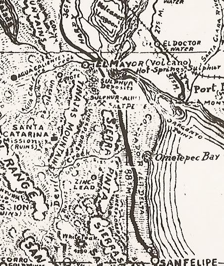
Northern Baja in 1930, see the Ensenada to San Felipe road:
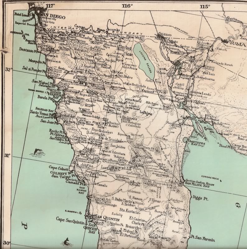
Here is a close up from 1930 map:
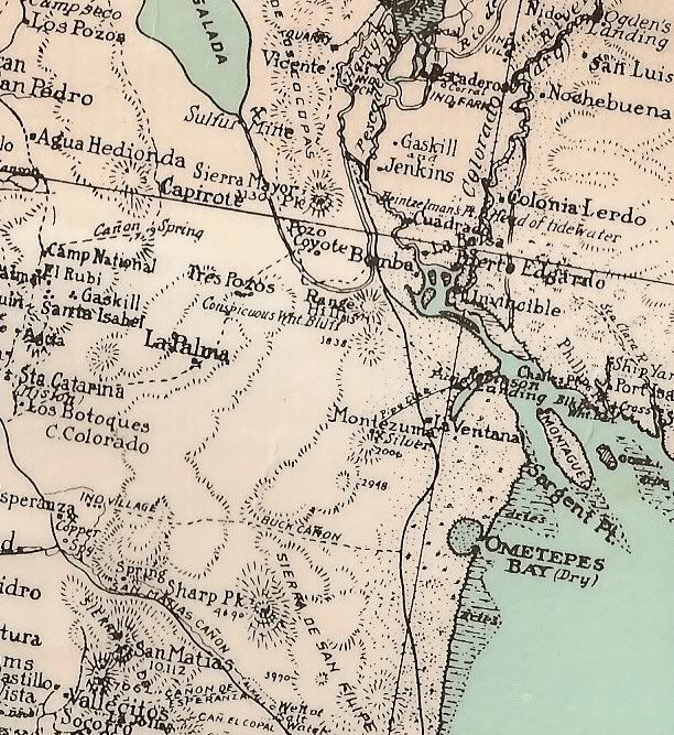
The trail called 'Buck Canyon' is approx. the Pole Line route.
The 1941 map, doesn't show any road across to San Felipe, as it was primarily a map showing north-south roads:
Just the road from Ensenada to El Alamo is shown:
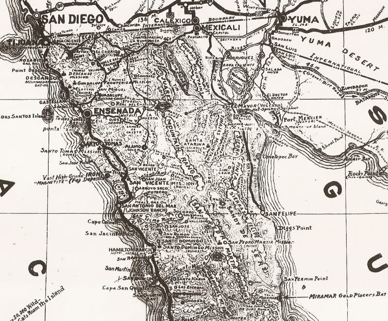
As to why the more difficult route over the summit and across the desert before turning south at Arroyo Grande...? Who knows. maybe they thought San
Matias Pass could get washed out too often or they wanted a route in no man's land for security?
[Edited on 4-20-2012 by David K]
|
|
|
Mexitron
Ultra Nomad
Posts: 3397
Registered: 9-21-2003
Location: Fort Worth, Texas
Member Is Offline
Mood: Happy!
|
|
I thought about the security thing but then the pole line road apparently joins up with the Mex Hwy 3 route around Trinidad.
|
|
|
David K
Honored Nomad
Posts: 64532
Registered: 8-30-2002
Location: San Diego County
Member Is Offline
Mood: Have Baja Fever
|
|
Well, keep in mind there was no Mex. 3 between Ensenada and San Felipe until about 30 years ago... and before then it was BC Hwy. 16... and pavement
didn't reach Hwy. 5 until late in 1977/ early 1978.
Pole line road probably went to Santa Catarina (near today's Independencia) and to El Alamo?
In 1967, pavement went about 10 miles out from Ensenada... and the rest was dirt road... no Hwy. designation, not graded. We got lost on the south end
of Diablo Dry Lake and went to Rancho Algodon, before turning back and heading to San Felipe! Fun times!
[Edited on 4-21-2012 by David K]
|
|
|
| Pages:
1
2
3 |


