| Pages:
1
2
3 |
56MM#
Junior Nomad

Posts: 59
Registered: 2-3-2010
Member Is Offline
|
|
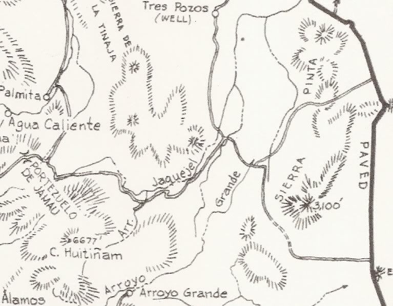
Are these two routes passable?
Heading down to explore area west of La Ventana. Does anyone know if the road through Canada Jaquegel and Canada de Enmedio (old Pole Line Road) and
the road through Canada Arroyo Grande and Canada Taraiso (ending at Choyall on Hwy 5) are passable in 4WD? I have read the Neil Johns article
Doing the Pole Line Dance. Was wondering if the road conditions have changed.
I drove the road between the valley west of Sierra las Tinajas and El Jamau last May and found the area to be virtually untouched, a real gem for
being so close to the border. 4WD was required.
Thanks.
|
|
|
Ken Cooke
Elite Nomad
Posts: 8971
Registered: 2-9-2004
Location: Riverside, CA
Member Is Offline
Mood: Pole Line Road postponed due to injury
|
|
| Quote: | Originally posted by 56MM#
Was wondering if the road conditions have changed.
I drove the road between the valley west of Sierra las Tinajas and El Jamau last May and found the area to be virtually untouched, a real gem for
being so close to the border. 4WD was required.
Thanks. |
4WD is definitely required. I went through 11 months ago. It was a great trip! Yes, the route goes through.
The Basketball Hill section is still blocked with the boulders blocking a portion of the route. A go-around exists, though.

|
|
|
TMW
Select Nomad
Posts: 10659
Registered: 9-1-2003
Location: Bakersfield, CA
Member Is Offline
|
|
I believe David K said there was a fence across arroyo Grande west of the SCORE race course turn off. A couple of miles further west the arroyo was
blocked by rocks just west of the dam a couple of years ago. Big Foot could probably make it. Also note that the gate at Choyall is locked or was the
last time I stopped.
|
|
|
David K
Honored Nomad
Posts: 65561
Registered: 8-30-2002
Location: San Diego County
Member Is Offline
Mood: Have Baja Fever
|
|
| Quote: | Originally posted by TW
I believe David K said there was a fence across arroyo Grande west of the SCORE race course turn off. A couple of miles further west the arroyo was
blocked by rocks just west of the dam a couple of years ago. Big Foot could probably make it. Also note that the gate at Choyall is locked or was the
last time I stopped. |
Yes, while on a preliminary search for the Lost Diaz Grave last January, southbound in Arroyo Grande: once we passed the POLE LINE ROAD (which crosses
Arroyo Grande, heading towards San Felipe from the Summit) we came to a cable stretched across the arroyo (perhaps to prevent Robby Gordon from making
a short cut, ala Matomi?).
Here is with the Baja 1000 2011 course and modern roads added (to the gold mine's wells):
The letter D in Pole Line Road on the above map is where the cable was stretched across Arroyo Grande.
|
|
|
Taco de Baja
Super Nomad
Posts: 1913
Registered: 4-14-2004
Location: Behind the Orange Curtain, CA
Member Is Offline
Mood: Dreamin' of Baja
|
|
A group of us went through the pole line road back in April 2012 in a 1996 Tacoma with a 3 inch lift, a newer model Tacoma 4 door, and a Toyota FJ.
It was a fun run, but about at the limit of our stock vehicles and I broke a sway bar in the 1996 Tacoma. We had to do a little road repair and brush
trimming, and the road is sometimes hard to see and follow through the washes.
Take it slow and a spotter helps in some areas.
see:
http://forums.bajanomad.com/viewthread.php?tid=59364
and
http://forums.bajanomad.com/viewthread.php?tid=59334
[Edited on 10-11-2012 by Taco de Baja]
Truth generally lies in the coordination of antagonistic opinions
-Herbert Spencer
|
|
|
TMW
Select Nomad
Posts: 10659
Registered: 9-1-2003
Location: Bakersfield, CA
Member Is Offline
|
|
I think it's time Ken put together another Pole Line Road trip only do it in reverse.
|
|
|
motoged
Elite Nomad
Posts: 6481
Registered: 7-31-2006
Location: Kamloops, BC
Member Is Offline
Mood: Gettin' Better
|
|
| Quote: | Originally posted by TW
I think it's time Ken put together another Pole Line Road trip only do it in reverse. |
TW,
That stuff is hard enough to get through without doing it all in reverse.....
http://www.youtube.com/watch?v=_QHXeC3YUxc
Don't believe everything you think....
|
|
|
Ken Cooke
Elite Nomad
Posts: 8971
Registered: 2-9-2004
Location: Riverside, CA
Member Is Offline
Mood: Pole Line Road postponed due to injury
|
|
| Quote: | Originally posted by TW
I think it's time Ken put together another Pole Line Road trip only do it in reverse. |
Doing the trip in reverse would delete some of the more serious challenges on that route.
|
|
|
Ken Cooke
Elite Nomad
Posts: 8971
Registered: 2-9-2004
Location: Riverside, CA
Member Is Offline
Mood: Pole Line Road postponed due to injury
|
|
Pole Line Pix
Some nice friends we met going into the trip - Huitzi and father Agustin.

Joe and his son drove this lightly modified LJ Wrangler. The rock sliders were pointing downward (wrong) to use as a step. This proved problematic
on this route. Joe told me that he would reverse them when he returned to his place at Pete's Camp.

Very rocky Canon Enmedio


Huitzi's Rubicon is lifted 4" with 33" tires, and by this photograph, you can hardly tell that he is modified.


|
|
|
Ken Cooke
Elite Nomad
Posts: 8971
Registered: 2-9-2004
Location: Riverside, CA
Member Is Offline
Mood: Pole Line Road postponed due to injury
|
|
Basketball Hill - one of the toughest challenges of the route
Huitzi and Agustin discuss options for tackling Basketball hill.


Here is where you feel like you are honestly going to flip over on your side and roll down the canyon (where I was standing when I took this photo).

By this point, you are home free...


|
|
|
Ken Cooke
Elite Nomad
Posts: 8971
Registered: 2-9-2004
Location: Riverside, CA
Member Is Offline
Mood: Pole Line Road postponed due to injury
|
|
Upper and Lower Jaquegel
Dropping into Jaquegel looked like this. It is a tall dropoff you need to drive down into. The camber makes it less appealing. Did you remember to
air down your tires?


One of the remaining poles


Clearing brush along the trail

This tricky fork must be walked up and determine which one is safest for you. We took the right fork as it has less camber . The dropoff is several
hundred feet down, so there is little room for error.

|
|
|
Ken Cooke
Elite Nomad
Posts: 8971
Registered: 2-9-2004
Location: Riverside, CA
Member Is Offline
Mood: Pole Line Road postponed due to injury
|
|
I like to call this "The Skateboard Ramp" because it resembles driving down a 1/4 pipe.

After crossing the Arroyo, you will see this sign indicating that you were a fool for traveling such a dangerous route and that no beer is available
for miles!

In fact, this sign indicates that you made the connection as the road is washed out as you cross the lower Jaquegel. You will drive into the arroyo,
and travel east - although, your instincts will try to lead you North across the crazy dropoffs and steep rocks. Traveling downstream will lead you
to this sign, and to Hwy 5. Good luck!
|
|
|
56MM#
Junior Nomad
Posts: 59
Registered: 2-3-2010
Member Is Offline
|
|
OK, the route between La Ventana and Choyall goes through, but I would not recommend doing it. The area west of La Ventana at the southern tip of the
Laguna Salada valley is being mined for water. While enroute to Canada Arroyo Grande, I passed two unattended large diesel generators running pumps
and surrounded by fences. There was also a new dirt road containing electrical lines and a pipeline. I suspect the pumps were supplying water to the
mines NNW of Crucero la Trinidad. A bartender in San Felipe told me they were mining gold in the mines.
Canada Arroyo Grande was easy to find: just head SSW towards the big opening. Once the wash narrowed with cliffs on each side, it was like being in
Anza Borrego, very similar to Fish Creek Wash. Just prior to Arroyo Grande (as depicted in the Baja Almanac), there is a swamp. I saw no recent tire
tracks going through this area. Although I didn't need 4WD, my truck got alot of pinstripes from the vegetation.
Arroyo Grande is an abandoned ranch with two old houses and a non-functioning windmill. Continuing SW, I climbed onto a plateau with abundant desert
plant life. The roads were in good condition, likely from ranch vehicles.
Upon dropping into Canada Taraiso, I came upon three ranch houses that looked like they were recently occupied. About half a mile south of the ranch
houses, there was a gate and fence that spanned the width of the wash. The gate was padlocked with a steel box around the padlock. Unlike the many
fences I have encountered south of the border, this one had steel poles set in concrete and two one-inch horizontal pipes (welded to the poles)
running along the bottom, the top pipe being around 18 inches above the ground. Obviously, the owners did not want anyone trespassing. It would have
been nice to encounter such an obstacle earlier in the trip and not be locked in.
Without going into details, I proceeded down Canada Taraiso for a mile and encountered a ranch house with a rancher saddling a horse. There was
another gate. This gate was unlocked. The rancher told me to proceed.
I encountered my last gate just before hitting Hwy 3. Although this one was sturdy and locked, it had barbed wire on each side, not steel pipes.
In summary, up until this point I never found myself locked in anywhere. It was always being locked out. Although a beautiful route, the locked
gates and fences make this trip unsuitable.
One final note: it appears that more and more trails in Baja Norte are being closed off by the rancheros. I suspect this is due to the increase in
dirt bikers and trophy truckers from Ensenada and Mexicali. Another era is coming to a close. It was nice while it lasted.
|
|
|
David K
Honored Nomad
Posts: 65561
Registered: 8-30-2002
Location: San Diego County
Member Is Offline
Mood: Have Baja Fever
|
|
We also drove to the water wells (serving the distant gold mine) from La Ventana, then south in Arroyo Grande (on the 2011 Baja 1000 course). Just
past the Pole Line Road crossing, there was a steel cable across Arroyo Grande last January. Did you see it and were you in Arroyo Grande at this
point or was there another way to drop into the arroyo before in snaked into the mountain? Thank you!
|
|
|
56MM#
Junior Nomad
Posts: 59
Registered: 2-3-2010
Member Is Offline
|
|
I never encountered a cable strecthed across Arroyo Grande. Until one gets into the area with vertical cliffs, Arroyo Grande is just a very wide sand
wash with alot of options to approach the narrow area. Once off the newly-cut roads for the wells and pipelines, I just pointed my truck towards the
gap and headed up the wash, which seemed like it was a quarter mile wide in places. I never saw a dedicated "road" in Arroyo Grande until the cliffs.
|
|
|
TMW
Select Nomad
Posts: 10659
Registered: 9-1-2003
Location: Bakersfield, CA
Member Is Offline
|
|
Interesting. What were you driving? So you did not use 4 wheel drive anywhere down Arroyo Grande to hwy 3?
|
|
|
David K
Honored Nomad
Posts: 65561
Registered: 8-30-2002
Location: San Diego County
Member Is Offline
Mood: Have Baja Fever
|
|
| Quote: | Originally posted by 56MM#
I never encountered a cable strecthed across Arroyo Grande. Until one gets into the area with vertical cliffs, Arroyo Grande is just a very wide sand
wash with alot of options to approach the narrow area. Once off the newly-cut roads for the wells and pipelines, I just pointed my truck towards the
gap and headed up the wash, which seemed like it was a quarter mile wide in places. I never saw a dedicated "road" in Arroyo Grande until the cliffs.
|
From the wells south (in Arroyo Grande, a wide open wash there) you are in the 2011 Baja 1000 course, and between the SCORE arrows and whoops, there
is no mistaking it. At the Pole Line road, Arroyo Grande is still wide, but between low cliffs and the Baja 1000 (turning left onto the Pole Line
Road) climbs out of the wash to the left, heading towards San Felipe. Just ahead (south) is where there was a steel cable across the arroyo, as if to
prevent racers or anyone from continuing up into the mountains in Arroyo Grande. This was last New Years weekend... 2 months after the Baja 1000.
|
|
|
56MM#
Junior Nomad
Posts: 59
Registered: 2-3-2010
Member Is Offline
|
|
95 4-Runner, mild suspension lift, 32" BFG Mud Terrains, Detroit Locker in the rear.
Until one gets to the swamp just before the actual Arroyo Grande Ranch (two abandoned buildings), the wash isn't narrow enough to string a cable.
Easy trip until you hit the first gate and fence. Have never seen anything this sturdy in a relatively remote area. It took five hours to get there
from La Ventana, and I only had 2-1/2 hours of light left.
|
|
|
David K
Honored Nomad
Posts: 65561
Registered: 8-30-2002
Location: San Diego County
Member Is Offline
Mood: Have Baja Fever
|
|
Well there indeed was a cable across the arroyo 10 months ago otherwise we wouldn't have turned back so soon. We weren't going as far as the ranch,
only into the canyon just south of the Pole Line Road crossing. I am driving a 2010 4WD Off Road TRD Tacoma . When did you go?
|
|
|
Ken Cooke
Elite Nomad
Posts: 8971
Registered: 2-9-2004
Location: Riverside, CA
Member Is Offline
Mood: Pole Line Road postponed due to injury
|
|
| Quote: | Originally posted by 56MM#
Another era is coming to a close. It was nice while it lasted. |
This is real bad news. With all of the dreaming of new baja adventures, hearing this is upsetting.
|
|
|
| Pages:
1
2
3 |


