| Pages:
1
2
3
4
5
6
..
12 |
BajaNomad
Super Administrator

Posts: 4980
Registered: 8-1-2002
Location: San Diego, CA
Member Is Offline
Mood: INTP-A
|
|
.

When I was young, I admired clever people. Now that I am old, I admire kind people.
â Rabbi Abraham Joshua Heschel
We know we must go back if we live, and we don`t know why.
â John Steinbeck, Log from the Sea of Cortez
Affordable Domain Name Registration/Management & cPanel Web Hosting:
https://www.regionalinternet.com |
|
|
Katiejay99
Nomad
Posts: 429
Registered: 9-3-2008
Location: Todos Santos
Member Is Offline
Mood: it is what it is
|
|
My internet literally just got up and running. THANK YOU powers that be.
We have intermittent spitting of some rain "Chispiando" and no wind. We really don't need wind nor rain, thank you very much. Everyone in town is
freaking out over Simon but I keep telling them that it will be a non-event. Let's hope I am right. It is HOT here and lots of "Bobos" - Gnats.
I will write something about the Odile experience when I have a chance.
|
|
|
Mexitron
Ultra Nomad
Posts: 3397
Registered: 9-21-2003
Location: Fort Worth, Texas
Member Is Offline
Mood: Happy!
|
|
| Quote: | Originally posted by bajacalifornian
SOCORRO ISLAND quick read
https://www.google.com/webhp?sourceid=navclient&ie=UTF-8...
"There is a naval station
WikiMiniAtlas
18°43′41″N 110°57′07″W / 18.728°N 110.952°W / 18.728; -110.952, established in 1957, with a population
of 250 (staff and families)" |
Hurricane Linda drove right over it in '97 too....
|
|
|
shari
Select Nomad
Posts: 13034
Registered: 3-10-2006
Location: bahia asuncion, baja sur
Member Is Offline
Mood: there is no reality except the one contained within us "Herman Hesse"
|
|
I truly hope all of you who suffered in Odile are spared this time! I know we are due our fair share and Juan is getting the plywood ready just in
case..never trust a hurricane right? I am starting preparations just in case...because as I have said before, if the swell is 15' and there is a full
moon high tide AND we get rain, flooding will occur.
|
|
|
rts551
Elite Nomad
Posts: 6699
Registered: 9-5-2003
Member Is Offline
|
|
probably coastal flooding anyway
|
|
|
BajaNomad
Super Administrator
Posts: 4980
Registered: 8-1-2002
Location: San Diego, CA
Member Is Offline
Mood: INTP-A
|
|
HURRICANE SIMON ADVISORY NUMBER 10
NWS NATIONAL HURRICANE CENTER MIAMI FL EP192014
800 PM PDT FRI OCT 03 2014
...SIMON BECOMES THE 13TH HURRICANE OF THE 2014 EASTERN NORTH
PACIFIC HURRICANE SEASON...
WATCHES AND WARNINGS
--------------------
THERE ARE NO COASTAL WATCHES OR WARNINGS IN EFFECT.
DISCUSSION AND 48-HOUR OUTLOOK
------------------------------
THE CENTER OF HURRICANE SIMON MOVED VERY CLOSE TO SOCORRO ISLAND
...MEXICO A FEW HOURS AGO...AND AT 800 PM PDT...0300 UTC..IS LOCATED
NEAR LATITUDE 19.2 NORTH...LONGITUDE 111.6 WEST. SIMON IS MOVING
TOWARD THE WEST-NORTHWEST NEAR 12 MPH...19 KM/H...AND THIS MOTION IS
EXPECTED TO CONTINUE THROUGH SATURDAY. A TURN TOWARD THE NORTHWEST
IS EXPECTED SATURDAY NIGHT OR SUNDAY.
SATELLITE DATA INDICATE THAT THE MAXIMUM SUSTAINED WINDS HAVE
INCREASED TO NEAR 75 MPH...120 KM/H...WITH HIGHER GUSTS. SOME
ADDITIONAL STRENGTHENING IS POSSIBLE DURING THE NEXT 24 HOURS...BUT
A GRADUAL WEAKENING SHOULD BEGIN THEREAFTER.
SIMON IS A SMALL TROPICAL CYCLONE. HURRICANE FORCE WINDS EXTEND
OUTWARD UP TO 10 MILES...20 KM...FROM THE CENTER...AND TROPICAL
STORM FORCE WINDS EXTEND OUTWARD UP TO 45 MILES...75 KM. A MEXICAN
NAVY AUTOMATIC WEATHER STATION ON SOCORRO ISLAND REPORTED
SUSTAINED WINDS OF 50 MPH...80 KM/HR AND A GUST TO 69 MPH...112
KM/HR A FEW HOURS AGO WHEN SIMON PASSED NEAR THAT ISLAND.
THE ESTIMATED MINIMUM CENTRAL PRESSURE IS 988 MB...29.18 INCHES.
HAZARDS AFFECTING LAND
----------------------
RAINFALL...SIMON IS EXPECTED TO PRODUCE TOTAL RAINFALL AMOUNTS OF
5 TO 10 INCHES WITH ISOLATED AMOUNTS AROUND 15 INCHES OVER THE NEXT
SEVERAL DAYS ACROSS BAJA CALIFORNIA SUR. THESE RAINS COULD CAUSE
FLASH FLOODING AND MUDSLIDES.
SURF...SWELLS GENERATED BY SIMON ARE STILL AFFECTING PORTIONS OF THE
SOUTHWESTERN COAST OF MEXICO. THESE SWELLS ARE LIKELY TO CAUSE
LIFE-THREATENING SURF AND RIP CURRENT CONDITIONS. PLEASE CONSULT
PRODUCTS FROM YOUR LOCAL WEATHER OFFICE.

When I was young, I admired clever people. Now that I am old, I admire kind people.
â Rabbi Abraham Joshua Heschel
We know we must go back if we live, and we don`t know why.
â John Steinbeck, Log from the Sea of Cortez
Affordable Domain Name Registration/Management & cPanel Web Hosting:
https://www.regionalinternet.com |
|
|
BajaNomad
Super Administrator
Posts: 4980
Registered: 8-1-2002
Location: San Diego, CA
Member Is Offline
Mood: INTP-A
|
|
HURRICANE SIMON DISCUSSION NUMBER 10
800 PM PDT FRI OCT 03 2014
Satellite estimates from TAFB, SAB and University of Wisconsin
CIMSS indicate that Simon has reached hurricane intensity with 65
kt. Simon is the 13th hurricane of the quite active eastern North
Pacific hurricane season of 2014, and another cyclone moving very
near or over Socorro Island, Mexico. Hourly observations from that
island provided by the Mexican Navy have been very useful in
determining the structure of Simon.
The cloud pattern is better organized tonight with a small but well-
defined inner core as indicated by the convective ring displayed in
several microwave overpasses during the past several hours. Simon
has the opportunity to strengthen a little more during the next 24
hours as it continues to move over a pool of 29.5 degree Celsius
water and extremely low shear. After 36 hours, the circulation of
Simon will begin to weaken as it moves over cooler waters and into a
more stable environment. The NHC intensity forecast follows the
trend of the guidance which suggests Simon reaching its peak
intensity in a day or so.
The best estimate of the initial motion is toward the west-northwest
or 285 degrees at 10 kt. However, Simon is reaching the southwestern
edge of the high pressure ridge centered over Mexico, and
approaching a large mid-level trough over the Central Pacific. This
pattern calls for a gradual turn toward the northwest and north
during the next 3 days as indicated in the official forecast. Beyond
3 days, the steering pattern becomes more complex, and the cyclone
either recurves to the northeast as suggested by the GFS or begins
to meander as forecast by the ECMWF. Since Simon is expected to be a
weaker storm by the end of the forecast period, it will likely move
little while embedded within the much lighter low-level flow. The
last portion of the forecast is highly uncertain.

When I was young, I admired clever people. Now that I am old, I admire kind people.
â Rabbi Abraham Joshua Heschel
We know we must go back if we live, and we don`t know why.
â John Steinbeck, Log from the Sea of Cortez
Affordable Domain Name Registration/Management & cPanel Web Hosting:
https://www.regionalinternet.com |
|
|
BajaNomad
Super Administrator
Posts: 4980
Registered: 8-1-2002
Location: San Diego, CA
Member Is Offline
Mood: INTP-A
|
|
.

When I was young, I admired clever people. Now that I am old, I admire kind people.
â Rabbi Abraham Joshua Heschel
We know we must go back if we live, and we don`t know why.
â John Steinbeck, Log from the Sea of Cortez
Affordable Domain Name Registration/Management & cPanel Web Hosting:
https://www.regionalinternet.com |
|
|
micah202
Super Nomad
Posts: 1615
Registered: 1-19-2011
Location: vancouver,BC
Member Is Offline
|
|
.
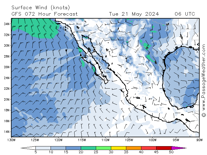
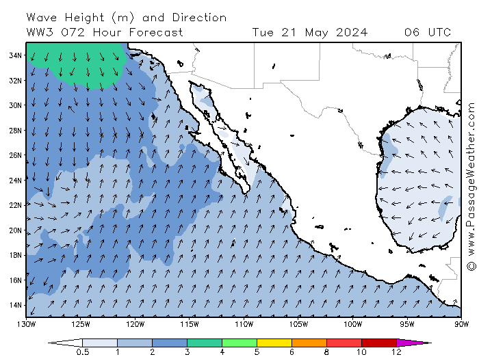
.....finally a bit of good news on passageweather,,it's showing a bit of ease in the windstrengths before hitting the asuncion area--hopefully that
trend continues!!
...those waveheights are rather more than Marie though
[Edited on 10-4-2014 by micah202]
|
|
|
shari
Select Nomad
Posts: 13034
Registered: 3-10-2006
Location: bahia asuncion, baja sur
Member Is Offline
Mood: there is no reality except the one contained within us "Herman Hesse"
|
|
Hmmm...here in Asuncion, we have been very fortunate to avoid much damage but when the stars and conditions align...things can get nasty. We can
endure a 15' swell IF there is no rain...but a high tide, big swell AND rain will cause alot of flooding. We havent had a gully washer in many years
here and lots of building has gone on so it will be interesting to see where the water will go...if it cant flow out to sea due to the high swell and
tide...ruh roh
|
|
|
BajaNomad
Super Administrator
Posts: 4980
Registered: 8-1-2002
Location: San Diego, CA
Member Is Offline
Mood: INTP-A
|
|
Update!: Simon intensifies; 115 MPH sustained winds
11:00 am PDT special update:
HURRICANE SIMON TROPICAL CYCLONE UPDATE
1100 AM PDT SAT OCT 04 2014
...NOAA HURRICANE HUNTER AIRCRAFT REPORTS THAT SIMON HAS BECOME A
MAJOR HURRICANE...
DATA FROM A NOAA HURRICANE HUNTER AIRCRAFT INDICATE THAT SIMON HAS
BECOME A MAJOR HURRICANE. THE MAXIMUM SUSTAINED WINDS ARE NEAR 115
MPH...185 KM/H...AND THE CENTRAL PRESSURE REPORTED BY THE AIRCRAFT
IS 952 MB...28.11 INCHES. THIS MAKES SIMON THE EIGHTH MAJOR
HURRICANE OF THE 2014 EASTERN NORTH PACIFIC HURRICANE SEASON.
SUMMARY OF 1100 AM PDT...1800 UTC...INFORMATION
--------------------------------------------------
LOCATION...20.3N 114.6W
ABOUT 255 MI...410 KM WNW OF SOCORRO ISLAND
ABOUT 350 MI...565 KM WSW OF THE SOUTHERN TIP OF BAJA CALIFORNIA
MAXIMUM SUSTAINED WINDS...115 MPH...185 KM/H
PRESENT MOVEMENT...WNW OR 295 DEGREES AT 13 MPH...20 KM/H
MINIMUM CENTRAL PRESSURE...952 MB...28.11 INCHES
------------------------------------------------------------------------------------------------
Earlier 8:00 am update:
HURRICANE SIMON ADVISORY NUMBER 12
800 AM PDT SAT OCT 04 2014
...SIMON RAPIDLY INTENSIFYING...
WATCHES AND WARNINGS
--------------------
THERE ARE NO COASTAL WATCHES OR WARNINGS IN EFFECT.
DISCUSSION AND 48-HOUR OUTLOOK
------------------------------
AT 800 AM PDT...1500 UTC...THE EYE OF HURRICANE SIMON WAS LOCATED
NEAR LATITUDE 20.2 NORTH...LONGITUDE 113.8 WEST. SIMON IS MOVING
TOWARD THE WEST-NORTHWEST NEAR 13 MPH...20 KM/H...AND THIS GENERAL
MOTION IS EXPECTED TO CONTINUE THROUGH TONIGHT. A TURN TOWARD THE
NORTHWEST IS FORECAST BY SUNDAY MORNING.
SATELLITE IMAGERY INDICATES THAT SIMON IS RAPIDLY INTENSIFYING.
MAXIMUM SUSTAINED WINDS HAVE INCREASED TO NEAR 110 MPH...175 KM/H...
WITH HIGHER GUSTS. ADDITIONAL STRENGTHENING IS LIKELY TODAY...AND
SIMON IS EXPECTED TO BECOME A MAJOR HURRICANE DURING THE NEXT FEW
HOURS. WEAKENING IS FORECAST TO BEGIN ON SUNDAY. A NOAA HURRICANE
HUNTER AIRCRAFT IS SCHEDULED TO INVESTIGATE SIMON LATER TODAY.
SIMON REMAINS A SMALL TROPICAL CYCLONE. HURRICANE FORCE WINDS
EXTEND OUTWARD UP TO 25 MILES...35 KM...FROM THE CENTER...AND
TROPICAL STORM FORCE WINDS EXTEND OUTWARD UP TO 70 MILES...110 KM.
THE ESTIMATED MINIMUM CENTRAL PRESSURE IS 966 MB...28.53 INCHES.
HAZARDS AFFECTING LAND
----------------------
RAINFALL...SIMON IS EXPECTED TO PRODUCE RAINFALL AMOUNTS OF 2 TO 4
INCHES WITH ISOLATED AMOUNTS AROUND 6 INCHES OVER THE NEXT SEVERAL
DAYS ACROSS BAJA CALIFORNIA SUR. THESE RAINS ARE EXPECTED TO CAUSE
FLASH FLOODING AND MUDSLIDES.
SURF...SWELLS GENERATED BY SIMON ARE AFFECTING PORTIONS OF THE
SOUTHWESTERN COAST OF MEXICO. THESE SWELLS ARE LIKELY TO CAUSE
LIFE-THREATENING SURF AND RIP CURRENT CONDITIONS. PLEASE CONSULT
PRODUCTS FROM YOUR LOCAL WEATHER OFFICE.
When I was young, I admired clever people. Now that I am old, I admire kind people.
â Rabbi Abraham Joshua Heschel
We know we must go back if we live, and we don`t know why.
â John Steinbeck, Log from the Sea of Cortez
Affordable Domain Name Registration/Management & cPanel Web Hosting:
https://www.regionalinternet.com |
|
|
micah202
Super Nomad
Posts: 1615
Registered: 1-19-2011
Location: vancouver,BC
Member Is Offline
|
|
.
.....another potentially mitigating factor is the storm's rotation.If it lands as shown,,I'd be more concerned with that area to the south that get's
the full brunt of storm-surge
[Edited on 10-4-2014 by micah202]
|
|
|
woody with a view
PITA Nomad
Posts: 15938
Registered: 11-8-2004
Location: Looking at the Coronado Islands
Member Is Offline
Mood: Everchangin'
|
|
Simon Cabron!
|
|
|
BajaNomad
Super Administrator
Posts: 4980
Registered: 8-1-2002
Location: San Diego, CA
Member Is Offline
Mood: INTP-A
|
|
HURRICANE SIMON DISCUSSION NUMBER 12
800 AM PDT SAT OCT 04 2014
Infrared satellite imagery indicates that Simon has undergone rapid
intensification during the past several hours. A small eye has
formed, and the cloud tops surrounding the eye are in the -75C to
-85C range. Satellite intensity estimates have increased to 102 kt
from TAFB and 90 kt from SAB, and the latest estimated from the
CIMSS ADT is 90 kt. Based on these, the initial intensity is
increased to 95 kt, and this could be conservative. A NOAA
Hurricane Hunter aircraft is scheduled to investigate Simon later
today.
The initial motion is now 295/11. Simon is expected to move
west-northwest to northwestward for the next 36 hours or so as is
approaches a weakness in the subtropical ridge to its north. After
that, the system is expected to turn northward and northeastward,
although there remains significant spread in the track guidance on
when and how fast this will occur. The GFS, GFS ensemble mean,
NAVGEM, and the GFDL show Simon moving quickly to the northeast,
eventually making landfall on the Baja California peninsula and in
northwestern Mexico. The ECMWF, UKMET, and CMC models show the turn
occurring later and farther west, and these models forecast the
cyclone to dissipate over water west of the Baja California
peninsula. The forecast track continues to compromise between these
two extremes in showing a slow northeastward motion after
recurvature. The new forecast track is similar to the previous track
and is slower than the model consensus.
How long the current rapid intensification will continue is
uncertain, as Simon is now moving over decreasing sea surface
temperatures. The new intensity forecast follows the guidance trend
of showing 12 hours more strengthening. Simon is now forecast to
become a major hurricane, and it would not be a surprise if it
reached a higher peak intensity than currently forecast. After 12
hours, cooler waters under the forecast track should result in a
weakening trend, and this should become more pronounced after 48
hours due to increasing shear. The new intensity forecast shows
rapid weakening after 48 hours, with Simon expected to become a
remnant low by the end of the forecast period. It should be noted
that, if Simon follows the GFS forecast track, it would likely
weaken more slowly than currently forecast since it would stay over
warmer water and encounters less shear.

When I was young, I admired clever people. Now that I am old, I admire kind people.
â Rabbi Abraham Joshua Heschel
We know we must go back if we live, and we don`t know why.
â John Steinbeck, Log from the Sea of Cortez
Affordable Domain Name Registration/Management & cPanel Web Hosting:
https://www.regionalinternet.com |
|
|
Zola
Nomad
Posts: 122
Registered: 9-7-2014
Location: San Juanico, Point Loma
Member Is Offline
Mood: Enthusiastic
|
|
According to the NHS, Simon is small in size and will make landfall as a tropical storm or remnant low in south-central Baja or dissipate over sea to
the west of central Baja. If it comes ashore, it might be stronger than intially expected. In any case it might bring rain to the region from Tuesday
onward.
This excerpt is from the most recent discussion at the NHS site at http://www.nhc.noaa.gov/text/refresh/MIATCDEP4+shtml/041448....
"The GFS, GFS ensemble mean, NAVGEM, and the GFDL show Simon moving quickly to the northeast, eventually making landfall on the Baja California
peninsula and in northwestern Mexico. The ECMWF, UKMET, and CMC models show the turn occurring later and farther west, and these models forecast the
cyclone to dissipate over water west of the Baja California peninsula. The forecast track continues to compromise between these two extremes in
showing a slow northeastward motion after recurvature. The new forecast track is similar to the previous track and is slower than the model
consensus."
[Edited on 10-4-2014 by Zola]
Sometimes the questions are complicated and the answers are simple. Dr. Seuss
Never wrestle with pigs. You both get dirty and the pig likes it. George Bernard Shaw
|
|
|
Zola
Nomad
Posts: 122
Registered: 9-7-2014
Location: San Juanico, Point Loma
Member Is Offline
Mood: Enthusiastic
|
|
I add that at the moment Simon is rapidly intensifying and is forecast to become a major hurricane later today, then diminish in strength by tomorrow.
It is far out at sea but might bring rainfall to southernmost BCS.
I wonder if anyone in the far south can give a report of conditions there today?
Sometimes the questions are complicated and the answers are simple. Dr. Seuss
Never wrestle with pigs. You both get dirty and the pig likes it. George Bernard Shaw
|
|
|
BajaNomad
Super Administrator
Posts: 4980
Registered: 8-1-2002
Location: San Diego, CA
Member Is Offline
Mood: INTP-A
|
|
| Quote: |
11:00 am PDT special update:
HURRICANE SIMON TROPICAL CYCLONE UPDATE
1100 AM PDT SAT OCT 04 2014
...NOAA HURRICANE HUNTER AIRCRAFT REPORTS THAT SIMON HAS BECOME A
MAJOR HURRICANE...
|
When I was young, I admired clever people. Now that I am old, I admire kind people.
â Rabbi Abraham Joshua Heschel
We know we must go back if we live, and we don`t know why.
â John Steinbeck, Log from the Sea of Cortez
Affordable Domain Name Registration/Management & cPanel Web Hosting:
https://www.regionalinternet.com |
|
|
BajaNomad
Super Administrator
Posts: 4980
Registered: 8-1-2002
Location: San Diego, CA
Member Is Offline
Mood: INTP-A
|
|
| Quote: |
It should be noted that, if Simon follows the GFS forecast track, it would likely weaken more slowly than currently forecast since it would stay
over warmer water and encounters less shear. |
When I was young, I admired clever people. Now that I am old, I admire kind people.
â Rabbi Abraham Joshua Heschel
We know we must go back if we live, and we don`t know why.
â John Steinbeck, Log from the Sea of Cortez
Affordable Domain Name Registration/Management & cPanel Web Hosting:
https://www.regionalinternet.com |
|
|
redmesa
Senior Nomad
Posts: 580
Registered: 3-12-2008
Location: Van Isle and Bahia Asuncion
Member Is Offline
|
|
11:00 AM PDT Sat Oct 4
Location: 20.3°N 114.6°W
Moving: WNW at 13 mph
Min pressure: 952 mb
Max sustained: 115 mph
|
|
|
Bruce R Leech
Elite Nomad
Posts: 6796
Registered: 9-20-2004
Location: Ensenada formerly Mulege
Member Is Offline
Mood: A lot cooler than Mulege
|
|
| Quote: | Originally posted by chuckie
Does not look flat from my front door this morning
[Edited on 10-1-2014 by BajaNomad] |
I'm from Steam Boat springs Co. what part of Co. are you from?
Bruce R Leech
Ensenada
 |
|
|
| Pages:
1
2
3
4
5
6
..
12 |