| Pages:
1
..
4
5
6
7
8
..
12 |
4x4abc
Ultra Nomad

Posts: 4199
Registered: 4-24-2009
Location: La Paz, BCS
Member Is Offline
Mood: happy - always
|
|
don't despair!
http://carlosnpainter.smugmug.com/Events/Glass-insulators-an...
Harald Pietschmann
|
|
|
chuckie
Elite Nomad
Posts: 6082
Registered: 2-20-2012
Location: Kansas Prairies
Member Is Offline
Mood: Weary
|
|
Its easy to do if you get too absorbed in the old pictures of tire tracks....
|
|
|
David K
Honored Nomad
Posts: 64526
Registered: 8-30-2002
Location: San Diego County
Member Is Offline
Mood: Have Baja Fever
|
|
Chiming in...
Quote: Originally posted by captkw  | | yes that's true... there s is many old story's about this...I thought you were implying the hwy 1 was a US thing.....which is a total mexico gig...I
drove it as it was being made...hrs watching a small diesel/wax/kerosene flame can on the side of a road to no where....DK and others can chime in
with that....BUT, I was 17 yrs old and on my own....So,,as a long term Res of Baja and mex (8yrs old) and I do have a firm thought/insight to many
things you gringos don't,,,,,,please keep that in mind...bein dias.....K&T |
The thread is titled 'POLE LINE ROAD...', and in the many discussions over the years (thanks to Neal Johns and others), as well as in the Lower
California Guidebook, the builders and purpose is described. The United States built the landing fields at Ensenada (now their airport El Cipres), El
Rosario on the mesa, and other places for the defense of California. We had three radar facilities in Baja California. Two were on the Pacific side
and one was at San Felipe. To communicate with the radar base at San Felipe, a telephone line from Ensenada was built across the peninsula, as well as
a road along side it. The 30 miles of it that has survived modern activity and can still be seen with cobblestone paving and telephone poles goes
across uninhabited desert. It is remote today, and far more so in 1942, when the United States built the road and pole line.
|
|
|
4x4abc
Ultra Nomad
Posts: 4199
Registered: 4-24-2009
Location: La Paz, BCS
Member Is Offline
Mood: happy - always
|
|
David or Ken,
could you put names to faces of participants - because I have forgotten at least half the names already.
screen names and vehicles would be cool, too
maybe use the image below:
https://www.facebook.com/photo.php?fbid=10153162681819277&am...
Harald Pietschmann - 4x4abc - black G500
Karl Volger - fernweh - black G500 (with roof tent)
Harald Pietschmann
|
|
|
David K
Honored Nomad
Posts: 64526
Registered: 8-30-2002
Location: San Diego County
Member Is Offline
Mood: Have Baja Fever
|
|
Coming right up Harald...
PS... as soon as you get any history on the road construction, please let me know!
|
|
|
4x4abc
Ultra Nomad
Posts: 4199
Registered: 4-24-2009
Location: La Paz, BCS
Member Is Offline
Mood: happy - always
|
|
digging through some papers I found that the road between Mexicali and San Felipe was also built by USACE in 41/42
Harald Pietschmann
|
|
|
Whale-ista
Super Nomad
Posts: 2009
Registered: 2-18-2013
Location: San Diego
Member Is Offline
Mood: Sunny with chance of whales
|
|
Thank you for the detailed reporting & photos of your adventures. Looks like a great trip.
\"Probably the airplanes will bring week-enders from Los Angeles before long, and the beautiful poor bedraggled old town will bloom with a
Floridian ugliness.\" (John Steinbeck, 1940, discussing the future of La Paz, BCS, Mexico)
|
|
|
David K
Honored Nomad
Posts: 64526
Registered: 8-30-2002
Location: San Diego County
Member Is Offline
Mood: Have Baja Fever
|
|
| Quote: Originally posted by 4x4abc | | digging through some papers I found that the road between Mexicali and San Felipe was also built by USACE in 41/42 |
Correct! Some years after the war, Mexico paved it... finished in 1953 or '55, as I recall. My dad told me in the early 60's on our trips south that
the U.S. built the new road to San Felipe.
Here is the group photo I took, with names...
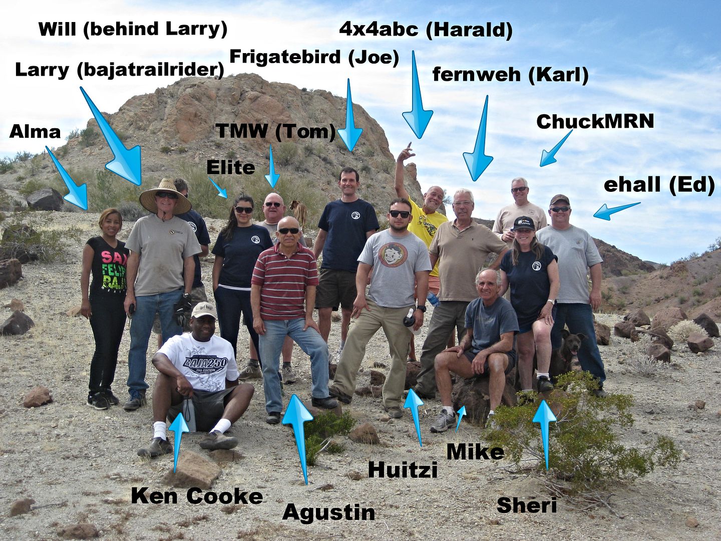
Here is Ken's camera with timer full group pic (I am between Chuck and Ed)...
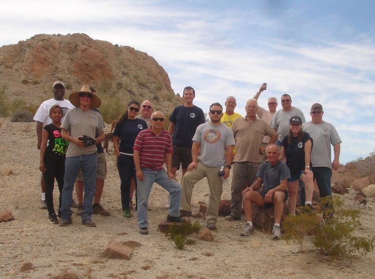
Names added to Ken's photo...
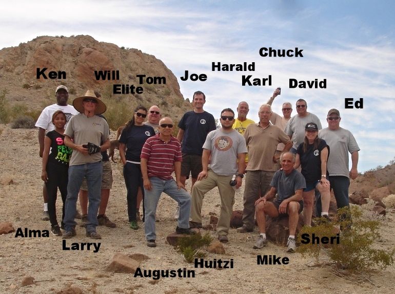
16 People, 12 Vehicles, 1 Adventure!
[Edited on 4-23-2015 by David K]
|
|
|
PaulW
Ultra Nomad
Posts: 3015
Registered: 5-21-2013
Member Is Offline
|
|
David, Are there some missing from the pic?
|
|
|
David K
Honored Nomad
Posts: 64526
Registered: 8-30-2002
Location: San Diego County
Member Is Offline
Mood: Have Baja Fever
|
|
That is everyone (12 vehicles) who did the Pole Line Road. MICK, John M, and others (3 vehicles? Ford, Blazier, Tacoma) returned to Rio Hardy Sunday
morning from our Saturday night camp near the Summit Road/ Locked Gate when MICK's FORD lost tranny oil. They went back out the same way we had driven
in Saturday, as far as I know.
[Edited on 4-14-2015 by David K]
|
|
|
rts551
Elite Nomad
Posts: 6699
Registered: 9-5-2003
Member Is Offline
|
|
| Quote: Originally posted by 4x4abc | | digging through some papers I found that the road between Mexicali and San Felipe was also built by USACE in 41/42 |
first road built in early 1900's
http://www.blueroadrunner.com/aboutsf.htm
|
|
|
David K
Honored Nomad
Posts: 64526
Registered: 8-30-2002
Location: San Diego County
Member Is Offline
Mood: Have Baja Fever
|
|
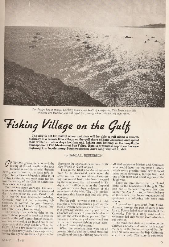
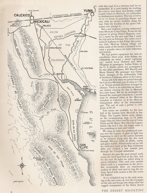
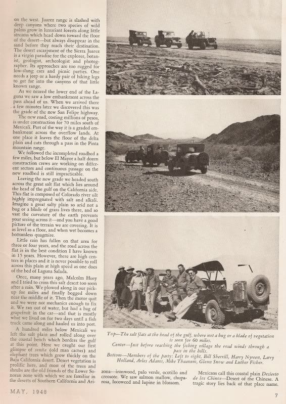
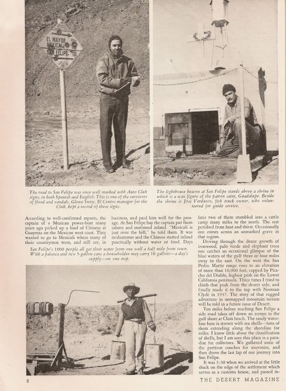
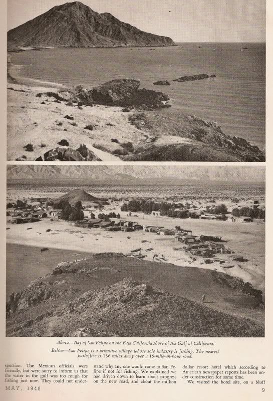
Trip Report from February 1948 on the new road...
|
|
|
motoged
Elite Nomad
Posts: 6481
Registered: 7-31-2006
Location: Kamloops, BC
Member Is Offline
Mood: Gettin' Better
|
|
Gracias, Harald.....now I can get on with my day 
Don't believe everything you think....
|
|
|
Mexitron
Ultra Nomad
Posts: 3397
Registered: 9-21-2003
Location: Fort Worth, Texas
Member Is Offline
Mood: Happy!
|
|
I still wonder why they built the PLR thru such inhospitable terrain when San Matias Pass seems like an easier route. Preventing sabotage by
isolating it was one idea on a thread a while back.
|
|
|
mtgoat666
Select Nomad
Posts: 17384
Registered: 9-16-2006
Location: San Diego
Member Is Offline
Mood: Hot n spicy
|
|

|
|
|
4x4abc
Ultra Nomad
Posts: 4199
Registered: 4-24-2009
Location: La Paz, BCS
Member Is Offline
Mood: happy - always
|
|
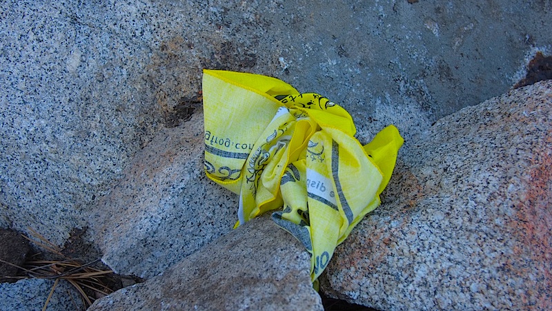
I hate those white flowers!
Since 1987 I have organized hundreds of events on the Rubicon Trail. Like many other trails threatened by closure. Would the users behave like
responsible citizens to minimize the threats? Hell, no!
One year, with some Sacramento grant money, stickers and bandanas were produced. Save the Rubicon. Eradicate white flowers.
Only to have some upstanding citizens use the bandanas to wipe their ass.
I am afraid, we will lose Baja the same way.
Harald Pietschmann
|
|
|
David K
Honored Nomad
Posts: 64526
Registered: 8-30-2002
Location: San Diego County
Member Is Offline
Mood: Have Baja Fever
|
|
| Quote: Originally posted by Mexitron | | I still wonder why they built the PLR thru such inhospitable terrain when San Matias Pass seems like an easier route. Preventing sabotage by
isolating it was one idea on a thread a while back. |
Steve, one thing we noticed was how unusual the route was to San Felipe from the highlands... It had to be to avoid detection through inhospitable and
non-populated lands... Where the PLR ran straight, like on the mesa east of 'Bad Hill', the phone poles were a long ways away from the road (harder to
spot the line without a road next to it?).
I hope we can dig up the building orders for it... Should be long ago declassified. I mean, instead of being attacked by the Japanese, we are best of
friends and driving their 4x4s!
|
|
|
David K
Honored Nomad
Posts: 64526
Registered: 8-30-2002
Location: San Diego County
Member Is Offline
Mood: Have Baja Fever
|
|
1962 vs. 2015 Road Logs
Added on the left, are mileages I recorded last week, on the 1962 edition of Gerhard & Gulick's Lower California Guidebook (where we all learned
about this road). This is westbound from Hwy. 5:
The first mileage was mostly parallel to the road used in 1960's that was not in Arroyo Grande for 5.3 miles from the wells to the Pole Line Road.
However it is quite close to Gulick's figures. The next three mileages were on the same road and I was the same of just a tad less.
The next point (road and trail to Jamau) we did not see, nor could I spot on Google Earth.
The next point (road to Guatamote) is located 0.2 mile past the detour access road we reached the Pole Line Road on.
The next point (Arroyo el Sáiz) is about where the locked gate was or within a mile. Again, as we had to detour around the locked gate, I could not
compare that mileage.
[Edited on 4-14-2015 by David K]
|
|
|
David K
Honored Nomad
Posts: 64526
Registered: 8-30-2002
Location: San Diego County
Member Is Offline
Mood: Have Baja Fever
|
|
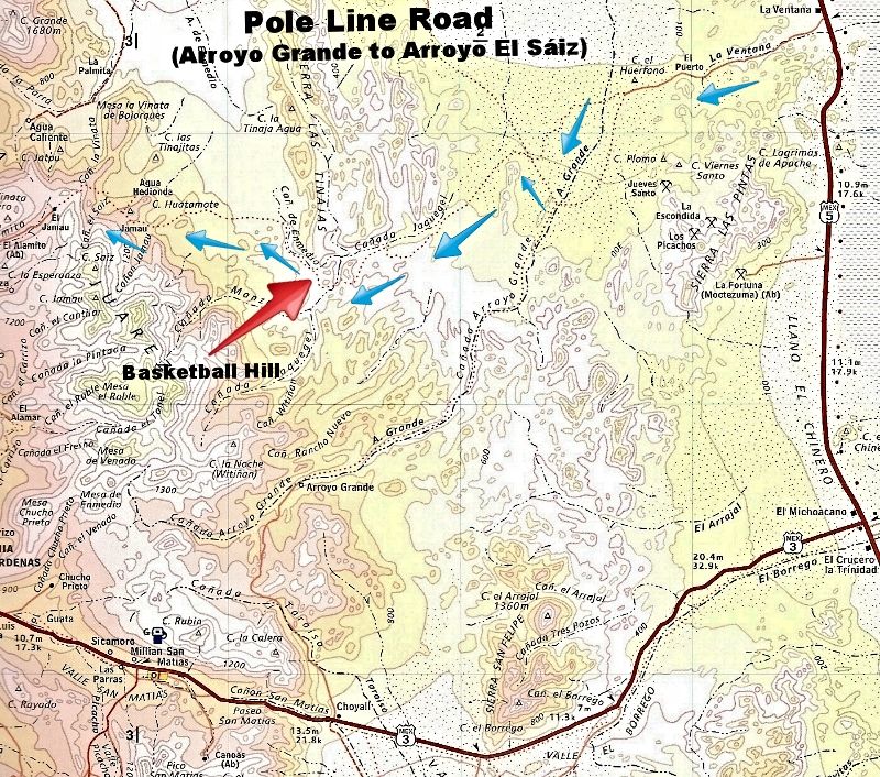
2015 Road Log HWY. 5/ La Ventana to Cohabuzo Junction via Pole Line Road
TRIP START (GPS MAP DATUM: WGS84, Google Earth) Total Miles/ Partial Miles:
0.0/ 0.0 HWY. 5, KM. 106+ (La Ventana + 1 km.). 31º43.900', -115º03.900'
6.0/ 6.0 T Junction, turn right (follow power line).
8.1/ 2.1 Race Course crosses road, continue straight.
12.5/ 4.4 Well Pump, turn left (south). Grading ends at second well (0.6 mi. south). Sandy road continues (deflating tires recommended).
17.8/ 5.3 Pole Line Road turns right (west). Road ahead goes 22 miles to Rancho Arroyo Grande, deep sand driving. A gate may prevent passage through
to HWY. 3 from the ranch. Road log turns onto Pole Line Road. 31º37.550', -115º15.700', elev. 800'. First 1942 telephone pole (cut) passed around Mile
21, on the left.
21.6/ 3.8 Detour off old road to right (ahead is washed out). Drop steeply into wash, go left then rejoin old road and climb out other side of wash.
22.4/ 0.5 T Junction. Remains of WWII construction camp. Ahead was once a road to Ejido Saldaña, now washed out. Turn left for Pole Line Road (small
landing strip possible here). 31º39.055', -115º18.190'.
26.4/ 4.0 Briefly drop into and back out of Arroyo Jaquegel, keeping to left side. Road repair at bottom of drop performed.
26.9/ 0.5 Bottom of steep grade to mesa. Many poles along mesa top, off to the right of the road at some distance.
28.7/ 1.8 Top of long grade, named 'Bad Hill'.
29.3/ 0.6 Pass close to one full length pole, a second is in the distance.
30.2/ 0.9 Reach wide Arroyo Jaquegel, turn left up arroyo. Rocky going for nearly 1 mile. 31º35.730'/-115º 23.120'
31.1/ 0.9 Road leaves Arroyo Jaquegel to left (south). Up arroyo 500 feet past road is wrecked Suzuki Samurai. Road crosses over hills and washes and
drops back into Arroyo Jaquegel a final time.
34.1/ 3.0 Road leaves Arroyo Jaquegel with a cobblestone paved ramp at bottom of grade. Palms are up Arroyo Jaquegel and can be seen from ledge above.
35.5/ 1.4 Top of 'Basketball Hill'. Steep grade down so named for the rocks in the road. Cut phone poles seen going down. A wrecked SUV is also
halfway down. 31º34.800', 115º26.300', elev. 1,800'.
35.6/ 0.1 In side canyon, bottom of 'Basketball Hill' grade.
35.7/ 0.1 Enter Cañada de Enmedio (Arroyo Jamau) with very rocky conditions for next 2 miles.
38.1/ 2.4 Cobblestone paving.
38.6/ 0.5 Long Cobblestone paving.
40.9/ 2.3 White Pila (water tank). 31º36.820', 115º30.070', elev. 2,300'.
41.6/ 0.7 Short cobblestone paving.
43.6/ 2.0 Fence gate (re-close after passing).
44.6/ 1.0 Y Intersection, keep right.
46.3/ 1.7 Road to right, go straight.
46.4/ 0.1 Y Fork, keep right. Left is new/ south summit road to top. 31º37.140', -115º34.740'
46.8/ 0.4 DETOUR road, turn left. Ahead is original road, blocked by locked gate.
47.3/ 0.5 DETOUR road turns sharp right, downhill, rough.
48.7/ 1.4 Cross Pole Line Road in Arroyo El Sáiz, Locked Gate on right, original Summit road up to left (2.3 miles to top). 31º37.815', -115º35.145',
elev. 2,900'.
Cohabuzo Junction is 25 miles north, Highway 2 is 73 miles north.
MAP OF ROAD LOG ROUTE:
[Edited on 4-24-2015 by David K]
|
|
|
David K
Honored Nomad
Posts: 64526
Registered: 8-30-2002
Location: San Diego County
Member Is Offline
Mood: Have Baja Fever
|
|
Photos from Sheri coming soon...
|
|
|
| Pages:
1
..
4
5
6
7
8
..
12 |


