| Pages:
1
..
8
9
10
11
12 |
David K
Honored Nomad

Posts: 64493
Registered: 8-30-2002
Location: San Diego County
Member Is Online
Mood: Have Baja Fever
|
|
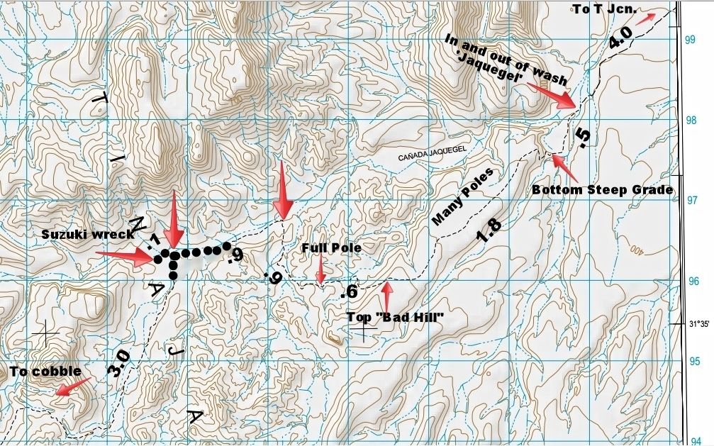
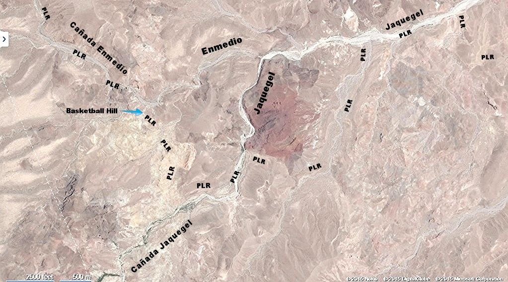
POLE LINE ROAD MILEAGE MAP
Experimenting with the most user friendly methods to make trip maps, here is one I did with my recorded mileages between points along the road,
pointed to with arrows (mileage between the arrows).
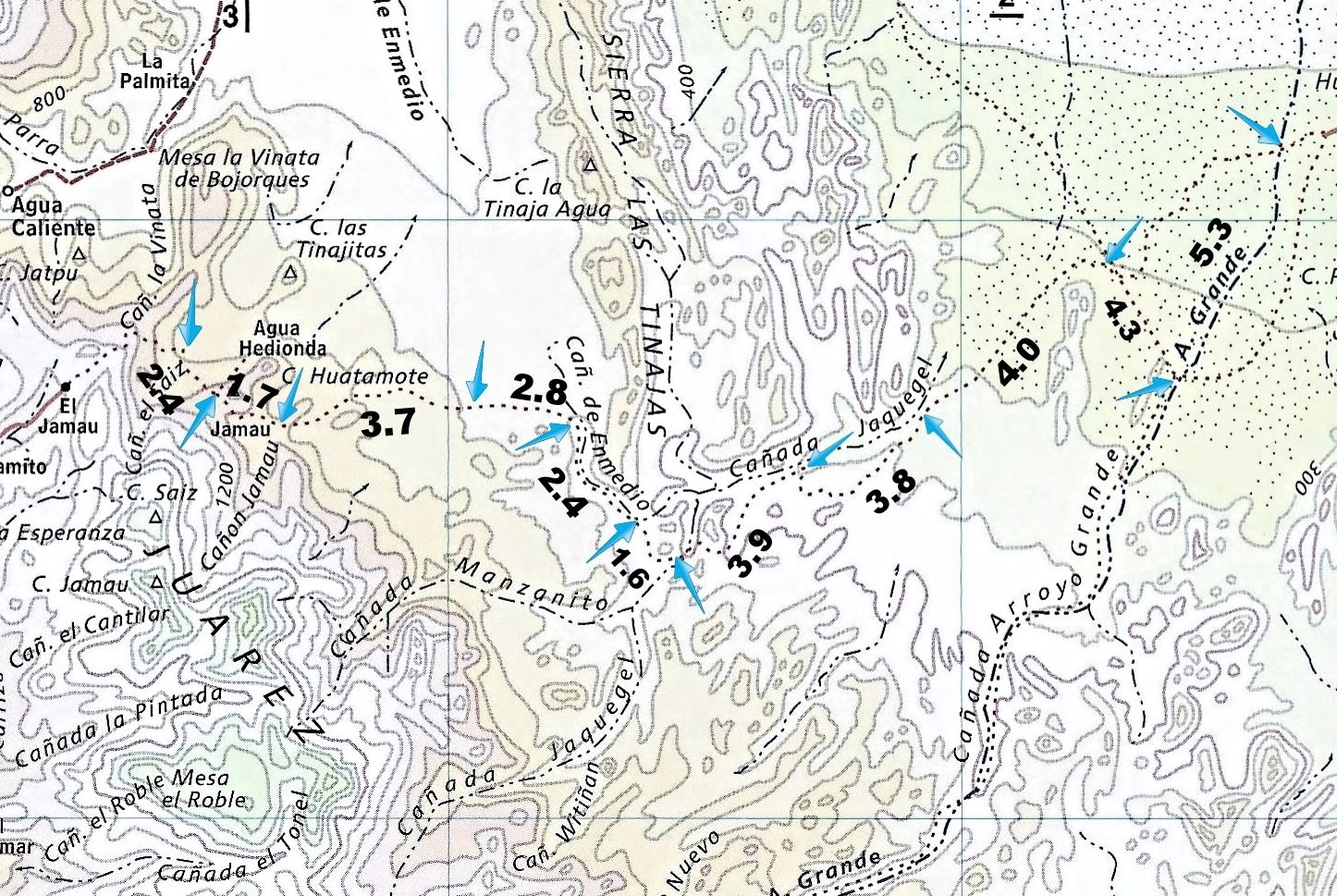
*On the west end, the first mileage is from the bottom of the summit/ locked gate (25 miles south of Cohabuzo Jcn.) on the detour route to...
*Rancho Huatamote road. 2.4 (if gate was open, subtract ~1 mile)
The next points are:
*Left at Y (Rancho/ Cañon Jamau road). 1.7
*The white water tank. 3.7
*Cobblestone road near Cañada de Enmedio. 2.8
*Leave Enmedio for bottom of Basketball Hill. 2.4
*Cobblestone ramp into Cañada Jaquegel. 1.6
*Leave Jaquegel to south. 3.9
*Briefly drop into Jaquegel final time. 3.8
*T Junction. 4.0
*Arroyo Grande. 4.3
*Wells (water pumps) for gold mine on Hwy. 5. 5.3
(Hwy. 5 by La Ventana is 12.5 miles east).
|
|
|
David K
Honored Nomad
Posts: 64493
Registered: 8-30-2002
Location: San Diego County
Member Is Online
Mood: Have Baja Fever
|
|
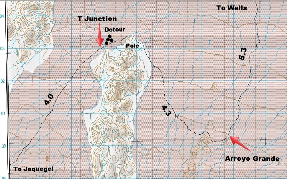
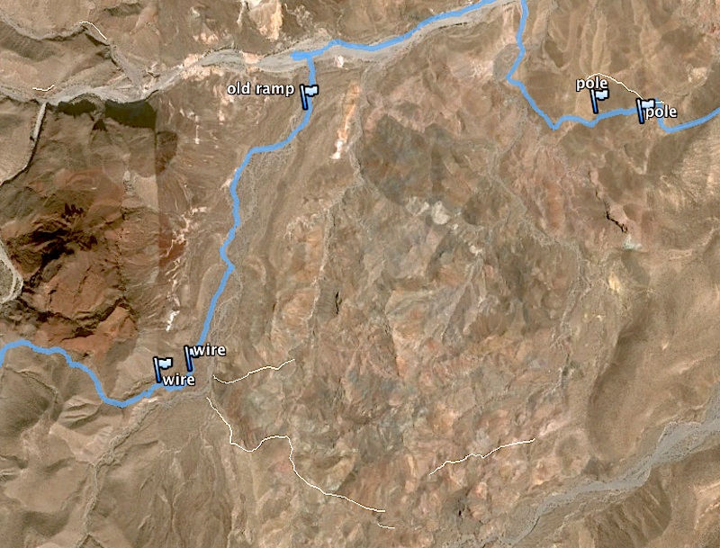
Map with labels added:
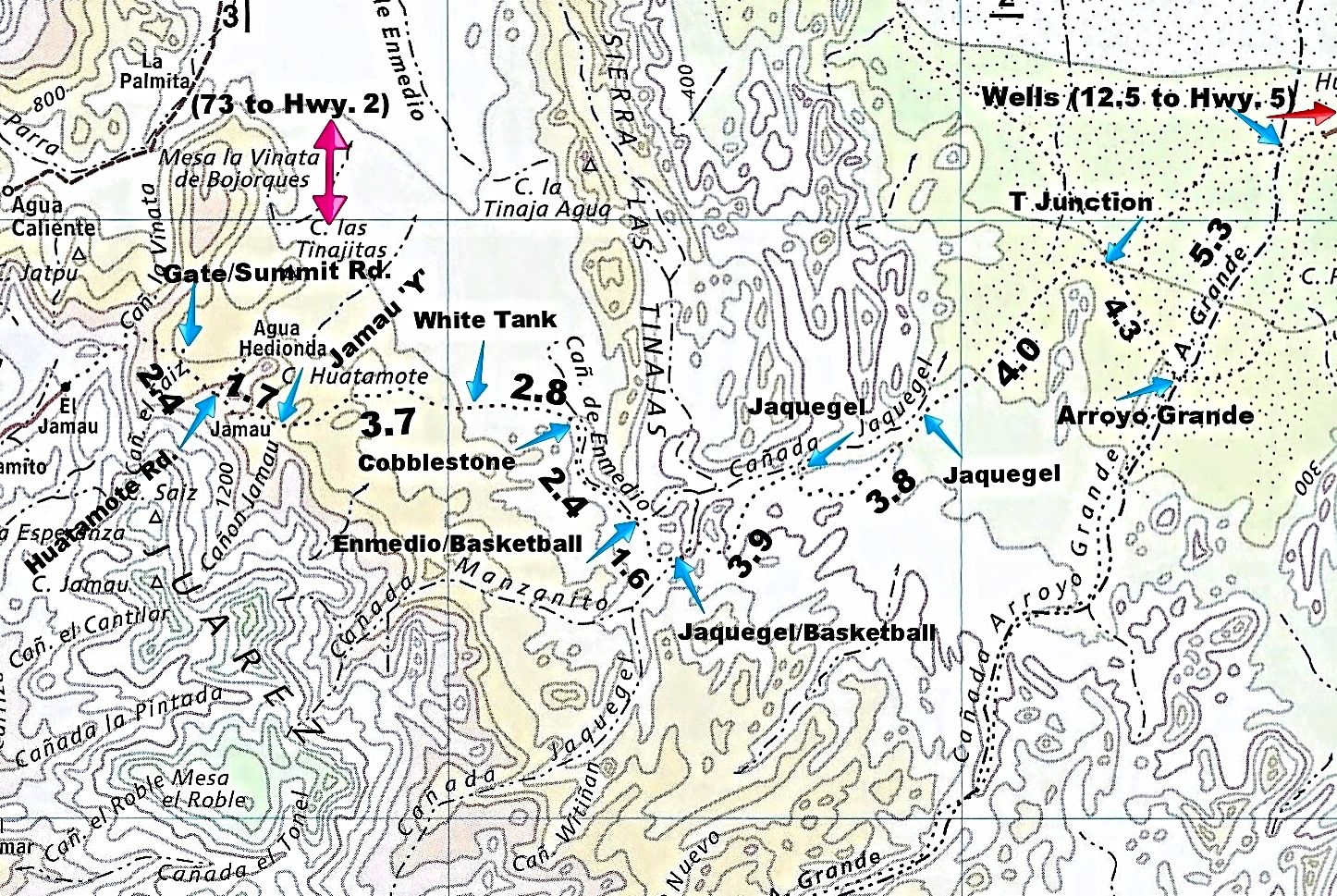
If I put too much text on the map it spoils it, but if I don't say enough, it can be unclear.
The full road log was posted earlier, so I just used some points from that log that are events on the map.
1942 Pole Line Road mileage as traveled in 2015 on modern map. The 73 mile road from Hwy. 2 to the gate is not shown. The Pole Line Road southeast
from Arroyo Grande is also not shown.
Map Notes:
Locked Gate/ 1st Summit Rd. to the Huatamote road (2.4): mileage shown is on the detour route (if the gate is open, subtract ~1 mile).
Just 0.1 mile west of the Huatamote Road is where the 2nd or Middle Summit road joins the Pole Line Road. 0.5 mile west of the Huatamote Road is where
the detour road meets the Pole Line Road.
The Jamau Y is also known as 'Left at Y'. Rancho Jamau may no longer be there. A road once climbed the mountain beyond, making this the Cañon Jamau or
3rd Summit road.
The 'Cobblestone' point shown is the third cobblestone going east, or the first of three upon exiting Cañada Enmedio going west. This was very close
to entering Cañada Enmedio eastbound.
Enmedio/Basketball is where the road leaves Enmedio and soon is at the west side of Basketball Hill, with the first telephone poles seen going east.
Jaquegel/Basketball is the east side of Basketball Hill where it meets Cañada Jaquegel via a cobblestone ramp (palms nearby).
Jaquegel (west) is the point where the eastbound road exits Jaquegel to the south (after 0.9 mile travel in the wide wash). A wrecked Samurai is 0.1
mile west of where the road enters the wide wash.
Jaquegel (east) is where the road briefly drops into Jaquegel a final time, road construction was performed here to exit Jaquegel.
T Junction. The map is not accurate, it is actually to the west of that narrow mountains north end, not to the north-east of it, where the map places
the road junction. This explains why the 4.0 mileage is longer looking than the 4.3 mileage that follows (eastbound).
The 5.3 miles from the Arroyo Grande junction to the wells, is in the arroyo, not on the road shown east of the arroyo.
[Edited on 4-23-2015 by David K]
|
|
|
David K
Honored Nomad
Posts: 64493
Registered: 8-30-2002
Location: San Diego County
Member Is Online
Mood: Have Baja Fever
|
|
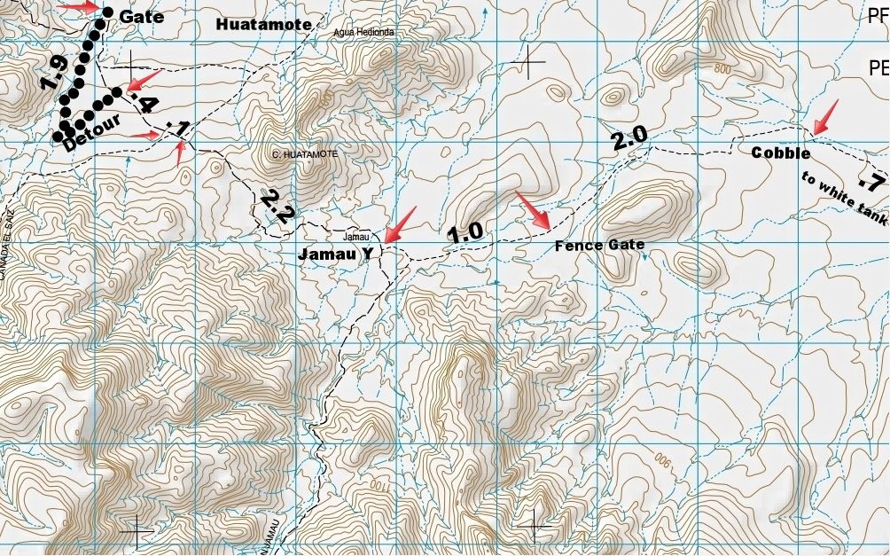
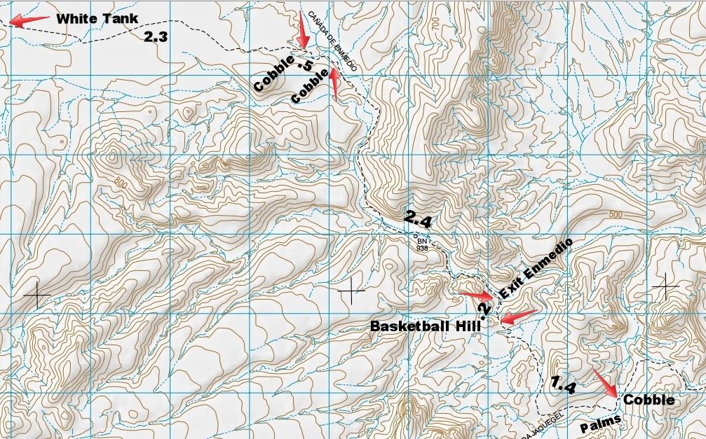
Pole Line Road on 4 Topos (labels + miles)
Please enjoy my work, today's project:
|
|
|
David K
Honored Nomad
Posts: 64493
Registered: 8-30-2002
Location: San Diego County
Member Is Online
Mood: Have Baja Fever
|
|
While seeking some reports on the building of the Pole Line Road, I found this little gem:
After a conference in San Diego, on cooperation in defense, attended by General C a r d e n a s, controls were placed on fishing activities in the
Gulf of California and the Pacific Coast north of Mazatlan. Soldiers and volunteer militia were assigned to construct telephone and telegraph lines
and roads in the peninsula.
More posted here:
http://forums.bajanomad.com/viewthread.php?tid=78618
|
|
|
PaulW
Ultra Nomad
Posts: 3009
Registered: 5-21-2013
Member Is Offline
|
|
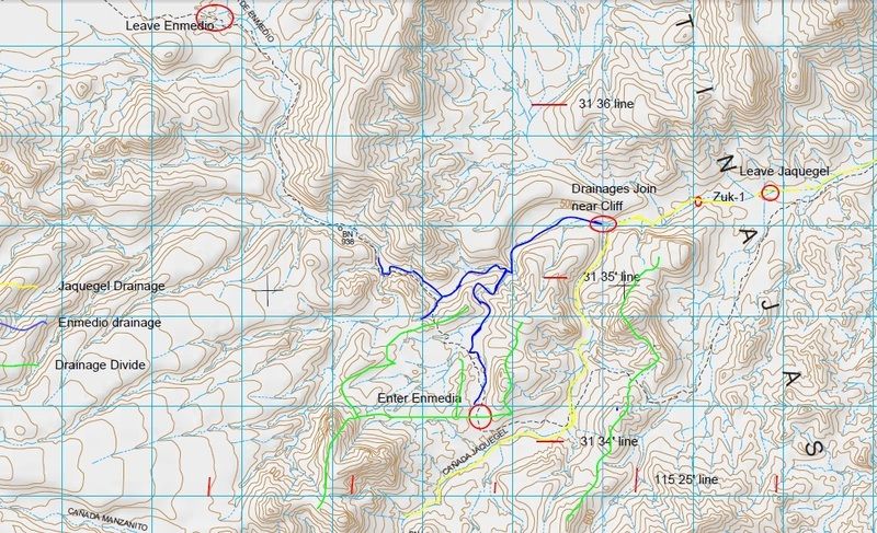
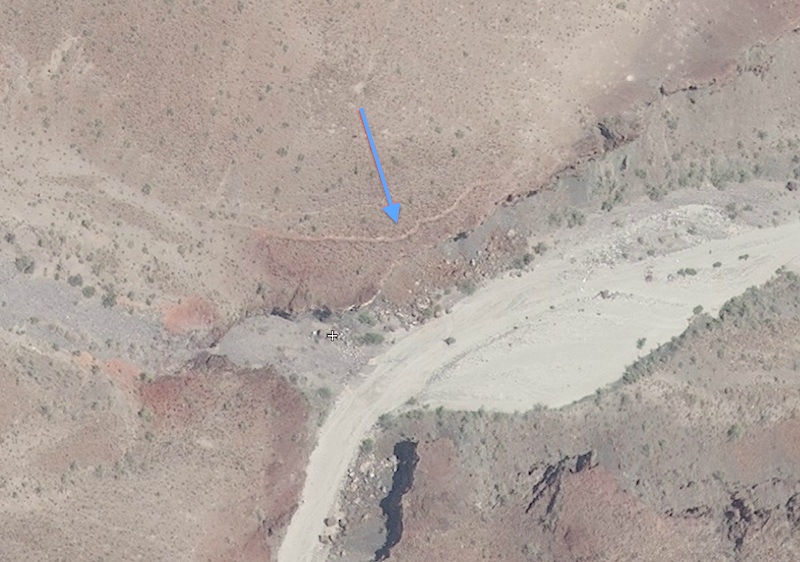
Where do Enmedio and Jaquegel merge?
The answer is it is not obvious even with the topo in front of me.
The picture sells the story
And here are some coords I pulled off the topo then loaded them into my GPS to get better accuracy by matching the waypoint to the real GPS track.
Junction of Enmedio and Jaquegel 31 35.358, -115 25.120
PLR leaves Jaquegel 31 34.15, -115 26.029
PLR then shortly enters Enmedio at 31 24.227, -115 26.056. And yes the PLR leaves then enters Enmedio in a short distance that I did not document.
You can see that track in the pic.
Cliff in Enmedio where the Zuk came tumbling from higher up in Enmedio is very close to the Jct of the two washes. At 31 35.2, -11525.147 This is
where I drove for my first trip. This year the canyon is filled with big boulders that prevented my return to view the cliffs.
Its interesting to me that Enmedio which drains from quite a ways north is just a tributary of Jaquegel which is a much larger drainage in the
overall scheme.
|
|
|
David K
Honored Nomad
Posts: 64493
Registered: 8-30-2002
Location: San Diego County
Member Is Online
Mood: Have Baja Fever
|
|
Gulick and the Mexican topos put the junction of Cañada Enmedio (Gulick calls Arroyo Jamau) and Jaquegel (Gulick spells Jaquejel) where your blue line
meets the yellow. Nice work!
|
|
|
PaulW
Ultra Nomad
Posts: 3009
Registered: 5-21-2013
Member Is Offline
|
|
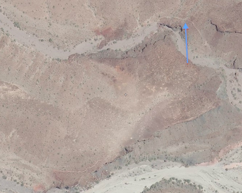
On my first trip I drove by the exit from Jaquegel. And I drove to the cliffs, found the Zuk. I certainly saw the two cliff areas, but not until
today did I recognize the lay of the land. We all headed back to find a passage. The no name small wash exit did not seem to be a good choice to
drive. Gave it a try and shortly found a hard place, back tracked and saw the faint track up the bank. Success continued.
On the most recent trip I found Jaquegel completely blocked at the narrows just past the new Zuk location.
If I go back to do the PLR again I will probably walk to the cliffs for pics.
|
|
|
David K
Honored Nomad
Posts: 64493
Registered: 8-30-2002
Location: San Diego County
Member Is Online
Mood: Have Baja Fever
|
|
Quote: Originally posted by PaulW  | On my first trip I drove by the exit from Jaquegel. And I drove to the cliffs, found the Zuk. I certainly saw the two cliff areas, but not until
today did I recognize the lay of the land. We all headed back to find a passage. The no name small wash exit did not seem to be a good choice to
drive. Gave it a try and shortly found a hard place, back tracked and saw the faint track up the bank. Success continued.
On the most recent trip I found Jaquegel completely blocked at the narrows just past the new Zuk location.
If I go back to do the PLR again I will probably walk to the cliffs for pics. |
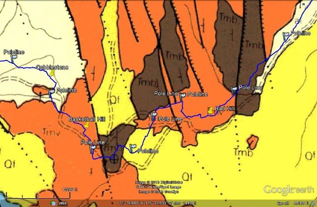
On the geology map, it shows a road bypassing Basketball Hill and staying in Enmedio to the Jaquegel junction (Zuk), plus a branch road going north
from it...
Here is that Geology Map from 1971 showing roads in the Basketball Hill area. There is an overlay (GE) of my blue line (true PLR location) and
markers...
|
|
|
4x4abc
Ultra Nomad
Posts: 4170
Registered: 4-24-2009
Location: La Paz, BCS
Member Is Offline
Mood: happy - always
|
|
I have driven the north bypass of the waterfall in 1986 - was pretty easy
there is also an interesting south alternative to the established trail (GE shows most of it)
Harald Pietschmann
|
|
|
David K
Honored Nomad
Posts: 64493
Registered: 8-30-2002
Location: San Diego County
Member Is Online
Mood: Have Baja Fever
|
|
| Quote: Originally posted by 4x4abc | I have driven the north bypass of the waterfall in 1986 - was pretty easy
there is also an interesting south alternative to the established trail (GE shows most of it) |
ON GE, the Basketball Hill region is under cloud cover, here is Bing with labels of the road and arroyos. I am curious where your south alternative
is?
[Edited on 4-26-2015 by David K]
|
|
|
4x4abc
Ultra Nomad
Posts: 4170
Registered: 4-24-2009
Location: La Paz, BCS
Member Is Offline
Mood: happy - always
|
|
here we go:
Harald Pietschmann
|
|
|
4x4abc
Ultra Nomad
Posts: 4170
Registered: 4-24-2009
Location: La Paz, BCS
Member Is Offline
Mood: happy - always
|
|
here is the waterfall bypass
Harald Pietschmann
|
|
|
4x4abc
Ultra Nomad
Posts: 4170
Registered: 4-24-2009
Location: La Paz, BCS
Member Is Offline
Mood: happy - always
|
|
here is the road into North Canyon (nameless on map)
Harald Pietschmann
|
|
|
David K
Honored Nomad
Posts: 64493
Registered: 8-30-2002
Location: San Diego County
Member Is Online
Mood: Have Baja Fever
|
|
Cool... how about the south road you mentioned?
|
|
|
PaulW
Ultra Nomad
Posts: 3009
Registered: 5-21-2013
Member Is Offline
|
|
Harald
How about a markup line on the H11B25 PDF?
Here is how -- Open the PDF Pull down menu:
View
Comment
Drawing markup
Now see the pencil in the tools side bar. Click on it for color choice.
Use eraser for mistakes.
Thanks PW
|
|
|
4x4abc
Ultra Nomad
Posts: 4170
Registered: 4-24-2009
Location: La Paz, BCS
Member Is Offline
Mood: happy - always
|
|
rather than boring you with faint lines, here is the kmz file:
PLR select
[Edited on 4-26-2015 by 4x4abc]
Harald Pietschmann
|
|
|
4x4abc
Ultra Nomad
Posts: 4170
Registered: 4-24-2009
Location: La Paz, BCS
Member Is Offline
Mood: happy - always
|
|
David,
how did you get the 1971 map? INEGI only has a 1976 version (showing different road detail)
Harald Pietschmann
|
|
|
4x4abc
Ultra Nomad
Posts: 4170
Registered: 4-24-2009
Location: La Paz, BCS
Member Is Offline
Mood: happy - always
|
|
question, how do you do an overlay or combine topos with GE?
Harald Pietschmann
|
|
|
PaulW
Ultra Nomad
Posts: 3009
Registered: 5-21-2013
Member Is Offline
|
|
We tried to do it with Powerpoint overlays. Huge time eater because the images do not line up even when you pin the same coords at 4 corners.
Very advanced.
There has to be a better way ,but I do not know?
Pw
|
|
|
David K
Honored Nomad
Posts: 64493
Registered: 8-30-2002
Location: San Diego County
Member Is Online
Mood: Have Baja Fever
|
|
On my previous computer I downloaded the 1971 Geological Map of Baja Norte onto GE, as a layer... and that is how I showed those close up maps, with
the PLR track in true location with it. The 1971 map, actual map I have, is a 3 part, huge map... and I got it because it showed many more dirt roads
than any map of the 1970's & 80's had.
I don't seem to have it on my new computer GE folder, so I need to search for the source of it... I am sure I discussed it here when it was made
available for GE overlay... Stay tuned!
EDIT: I checked all my KMZ files saved off the old PC om my portable hard drive... nada! Now I will need to find how or where that 1971 Geology map
was located... stay tuned!
EUREKA!!!: http://www.geology.sdsu.edu/kmlgeology/kmz/baja140/baja140.h...
[Edited on 4-27-2015 by David K]
|
|
|
| Pages:
1
..
8
9
10
11
12 |


