| Pages:
1
..
5
6
7
8
9
..
12 |
4x4abc
Ultra Nomad

Posts: 4199
Registered: 4-24-2009
Location: La Paz, BCS
Member Is Offline
Mood: happy - always
|
|
David,
Cañon Jamau drains into Arroyo de Enmedio - not into Cañada de Enmedio
[Edited on 4-19-2015 by 4x4abc]
Harald Pietschmann
|
|
|
David K
Honored Nomad
Posts: 64526
Registered: 8-30-2002
Location: San Diego County
Member Is Online
Mood: Have Baja Fever
|
|
Howard Gulick called it Arroyo Jamau, so I added that to the Almanac name Enmedio just to be clear on where we were discussing.
|
|
|
4x4abc
Ultra Nomad
Posts: 4199
Registered: 4-24-2009
Location: La Paz, BCS
Member Is Offline
Mood: happy - always
|
|
Google Earth has the answer for you
Harald Pietschmann
|
|
|
PaulW
Ultra Nomad
Posts: 3015
Registered: 5-21-2013
Member Is Offline
|
|
It sure has been a learning experience catching up with you guys.
The Almanac shows Can Enmedio heading a long way N after the PLR exits the canyon. It also shows the PLR when traveling west from the Enmedio exit
then heads for the white tank plateau.
I thought the PLR entered Can Jamau from the east (white tank) at the locked gate? Then Jamau canyon/wash/arroyo followed the track north (the one Ken
used for access to the PLR)?
I am in the states with limited resources and need info for Google Earth. Can you provide the coordinates for:
Bad hill, Jaquegel/Enmedio junction, Bottom of the hill that needed your reconstruction.
Also a picture of the 62 Gulick map showing the area near the locked gate including the summit would help.
Thanks, Paul
|
|
|
4x4abc
Ultra Nomad
Posts: 4199
Registered: 4-24-2009
Location: La Paz, BCS
Member Is Offline
Mood: happy - always
|
|
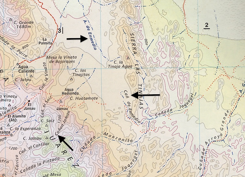
here is what I am talking about :
Cañon Jamau drains into Arroyo de Enmedio (flowing north)
Cañon de Enmedio (flowing south) is the one that drains into Cañada Jaquegel
Harald Pietschmann
|
|
|
David K
Honored Nomad
Posts: 64526
Registered: 8-30-2002
Location: San Diego County
Member Is Online
Mood: Have Baja Fever
|
|
I am not disagreeing with the modern name (Enmedio)... I included the Gulick applied name (Jamau) as that is
the name HE gave to the same location... see Mile 36.3 from his book, I was comparing the 1962 book road log to mine:
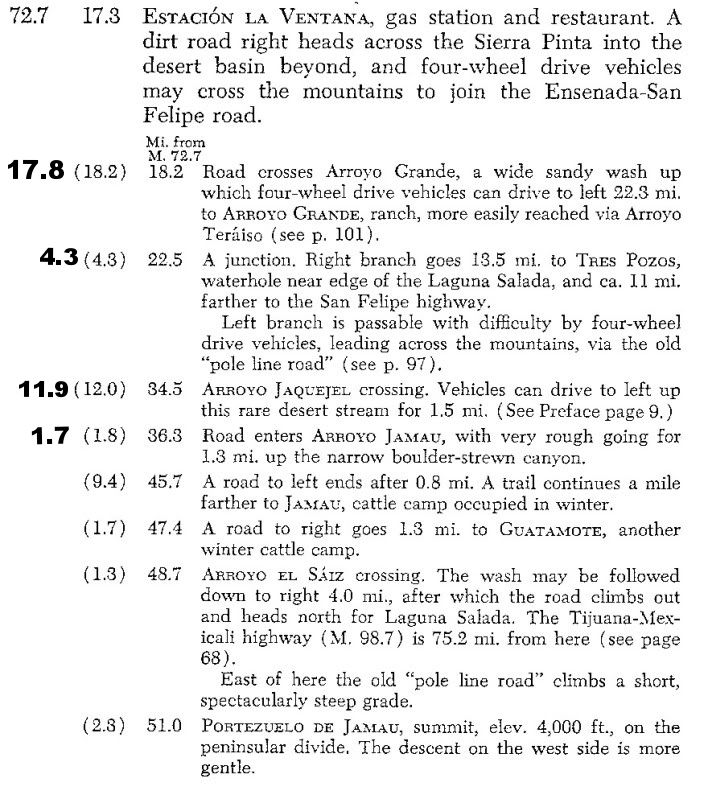
[Edited on 4-15-2015 by David K]
|
|
|
David K
Honored Nomad
Posts: 64526
Registered: 8-30-2002
Location: San Diego County
Member Is Online
Mood: Have Baja Fever
|
|
Quote: Originally posted by PaulW  | It sure has been a learning experience catching up with you guys.
The Almanac shows Can Enmedio heading a long way N after the PLR exits the canyon. It also shows the PLR when traveling west from the Enmedio exit
then heads for the white tank plateau.
I thought the PLR entered Can Jamau from the east (white tank) at the locked gate? Then Jamau canyon/wash/arroyo followed the track north (the one Ken
used for access to the PLR)?
I am in the states with limited resources and need info for Google Earth. Can you provide the coordinates for:
Bad hill, Jaquegel/Enmedio junction, Bottom of the hill that needed your reconstruction.
Also a picture of the 62 Gulick map showing the area near the locked gate including the summit would help.
Thanks, Paul
|
The Almanac/ Mexican map makers have switched names with arroyos, canyons, and bays in many places with the historic names.
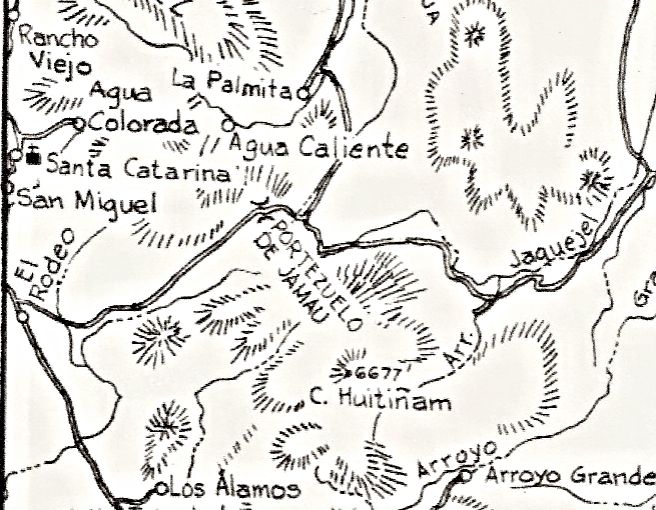
The Pass that the Pole Line Road uses is/was Portezuelo de Jamau, regardless of what the Almanac calls it today. There also could be more than one
Jamau, such as Cañon de Jamau vs. Portezuelo de Jamau.
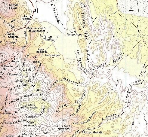
Here's the Gulick map of the area... followed by the 2009 Almanac map...
|
|
|
PaulW
Ultra Nomad
Posts: 3015
Registered: 5-21-2013
Member Is Offline
|
|
Harald, Thanks my eye sight is failing, but I see on GE that "A Enmedio" does join "C Jamau". Looks like "A Enmedio" begins on high ground Plateau N
of the white tank. When you drive the wash I never suspected that there were two washes joining.
Gulick said words about "A/C El Saiz" Do you suppose "C jamau" and Saiz are being confused?
David, do you have the INEGI topo to see if it sheds any light on some names?
Thanks for helping me out, Paul
|
|
|
4x4abc
Ultra Nomad
Posts: 4199
Registered: 4-24-2009
Location: La Paz, BCS
Member Is Offline
Mood: happy - always
|
|
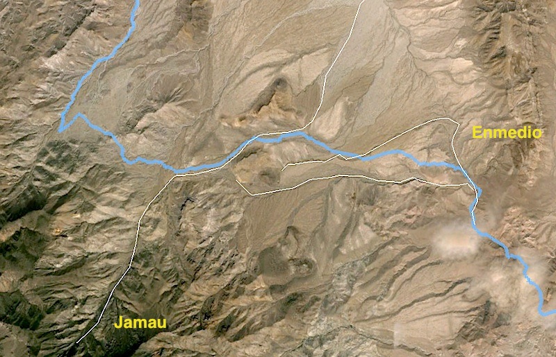
thanks to Google Earth we can now see clearly that Cañon Jamau drains north.
It's easy to mistake Jamau as the source for Enmedio - that's why Gulick named Enmedio Jamau
And with high water flow, some Jamau waters actually enter Enmedio
(white lines are the water drains - PLR in blue)
Harald Pietschmann
|
|
|
4x4abc
Ultra Nomad
Posts: 4199
Registered: 4-24-2009
Location: La Paz, BCS
Member Is Offline
Mood: happy - always
|
|
| Quote: Originally posted by PaulW | Harald, Thanks my eye sight is failing, but I see on GE that "A Enmedio" does join "C Jamau". Looks like "A Enmedio" begins on high ground Plateau N
of the white tank. When you drive the wash I never suspected that there were two washes joining.
Gulick said words about "A/C El Saiz" Do you suppose "C jamau" and Saiz are being confused?
David, do you have the INEGI topo to see if it sheds any light on some names?
Thanks for helping me out, Paul
|
I checked H11B25 and the names are Saiz, Jamau, Enmedio from west to east. The topo also confirms the north drainage of Jamau
Harald Pietschmann
|
|
|
4x4abc
Ultra Nomad
Posts: 4199
Registered: 4-24-2009
Location: La Paz, BCS
Member Is Offline
Mood: happy - always
|
|
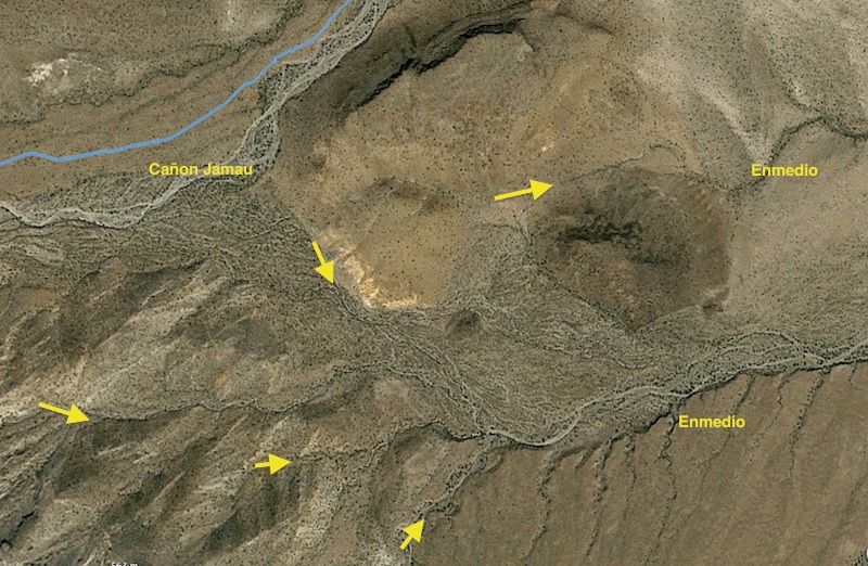
here is the divide between Jamau and the beginning of the 2 arms of Enmedio
Harald Pietschmann
|
|
|
David K
Honored Nomad
Posts: 64526
Registered: 8-30-2002
Location: San Diego County
Member Is Online
Mood: Have Baja Fever
|
|
Arroyo el Sáiz is the bottom of the summit grade, where the locked gate is facing, and where we camped Saturday night.
|
|
|
chuckie
Elite Nomad
Posts: 6082
Registered: 2-20-2012
Location: Kansas Prairies
Member Is Offline
Mood: Weary
|
|
Whew, I am so glad we got that resolved.....
|
|
|
4x4abc
Ultra Nomad
Posts: 4199
Registered: 4-24-2009
Location: La Paz, BCS
Member Is Offline
Mood: happy - always
|
|
you are absolutely right! why would you care
some of us do - most don't
it's all good!
Harald Pietschmann
|
|
|
chuckie
Elite Nomad
Posts: 6082
Registered: 2-20-2012
Location: Kansas Prairies
Member Is Offline
Mood: Weary
|
|
It was keeping me awake nights....
|
|
|
mtgoat666
Select Nomad
Posts: 17389
Registered: 9-16-2006
Location: San Diego
Member Is Offline
Mood: Hot n spicy
|
|
you should use the online INEGI map to see what the mother ship decrees to be the proper geographic names.
what geographic names do the locals use?
|
|
|
TMW
Select Nomad
Posts: 10659
Registered: 9-1-2003
Location: Bakersfield, CA
Member Is Offline
|
|
[Can you provide the coordinates for:
Bad hill, Jaquegel/Enmedio junction, Bottom of the hill that needed your reconstruction.
Also a picture of the 62 Gulick map showing the area near the locked gate including the summit would help.
Thanks, Paul]
Paul if you still need the coordinates they are: In degrees, decimal minutes.
Bad Hill 31-36.160x115-21.050
Jaq-Enm jct 31-35.350x115-25.100
Hill reconstruction 31-36.500x115-20.740
|
|
|
David K
Honored Nomad
Posts: 64526
Registered: 8-30-2002
Location: San Diego County
Member Is Online
Mood: Have Baja Fever
|
|
| Quote: Originally posted by mtgoat666 |
you should use the online INEGI map to see what the mother ship decrees to be the proper geographic names.
what geographic names do the locals use? |
There are no locals on the Pole Line Road 30 mile section we are discussing. In other words, no homes or ranches along the way that can be seen. One
ranch near the west end, and who probably put up the locked gate, a over a mile north of the Pole Line Road, near that gate on the west end. This is
at or near the ranch called Guatamote in the Lower California Guidebook.
As stated before, the Mexican made topo maps are not 100% accurate with names, so we use them to help spot where we are talking about, but they are
often in error.
|
|
|
David K
Honored Nomad
Posts: 64526
Registered: 8-30-2002
Location: San Diego County
Member Is Online
Mood: Have Baja Fever
|
|
Insulator model on the Pole Line Road
Scroll down to the second photo...
http://www.hemingray.info/database/detail.php?cd=122
|
|
|
PaulW
Ultra Nomad
Posts: 3015
Registered: 5-21-2013
Member Is Offline
|
|
Tom,
I will use the info when I get back from my trip to Denver. Its important to me to correct my PLR GPS track WPs.
Thanks
======
| Quote: Originally posted by TMW | [Can you provide the coordinates for:
Bad hill, Jaquegel/Enmedio junction, Bottom of the hill that needed your reconstruction.
Also a picture of the 62 Gulick map showing the area near the locked gate including the summit would help.
Thanks, Paul]
Paul if you still need the coordinates they are: In degrees, decimal minutes.
Bad Hill 31-36.160x115-21.050
Jaq-Enm jct 31-35.350x115-25.100
Hill reconstruction 31-36.500x115-20.740 |
|
|
|
| Pages:
1
..
5
6
7
8
9
..
12 |


