| Pages:
1
2
3 |
4x4abc
Ultra Nomad

Posts: 4170
Registered: 4-24-2009
Location: La Paz, BCS
Member Is Offline
Mood: happy - always
|
|
how do you do the overlay?
Harald Pietschmann
|
|
|
David K
Honored Nomad
Posts: 64493
Registered: 8-30-2002
Location: San Diego County
Member Is Offline
Mood: Have Baja Fever
|
|
I ask a knowledgeable Nomad for help!!! He has been teaching me...
LOL
I am learning right now... the one above was done for me and he is exchanging emails with me now in hopes to teach this old guy a new trick!
Once I know how, I will share with you the steps... I will make it so anyone should be able to easily do it... like I have with how to set your photo
uploading size... but there are still some who don't or won't.
|
|
|
David K
Honored Nomad
Posts: 64493
Registered: 8-30-2002
Location: San Diego County
Member Is Offline
Mood: Have Baja Fever
|
|
Transparency maps over Google Earth
I will post this separately once I word it so anyone can do it...
Bryan McKenzie has been helping me do this... poor guy didn't know I would be such a problem, lol!
1) Map you want to overlay must have url (web address, not from your PC folder)... http:// etc.
2) Open Google Earth, and drop the eye view down so you are over the area, not at an angle, looking at it. have it bigger than the area of the map you
want to paste over it.
3) Click on the Image Overlay+ button (along the top of the GE page, 4th to right from the yellow push pin button). Pop up appears.
4) Give the map a name then paste the map url into the pop up box, and slide then transparency adjuster from opaque to the left, somewhere between
clear and the halfway point on the slider (to see through your map and onto Google Earth).
5) Click OK, and move the pop up box over to the left side so it isn't blocking your map view, but so you can still grab it.
6) There should be green alignment tools around the map and a cross in the middle. Use these to stretch or shrink your map to align it with known
points on Google Earth... If not there, right click on the map name, listed on your Google Earth left side menu, and click Properties at the bottom of
the box that appears. The pop up for that map appears, and the alignment green lines are around your map. If you have multiple maps, you can only
click on one at a time for adjusting.
You can grab the sides or corners of the map and change its shape and size to align with the Google Earth view below it. The diamond is for tilting
the map. The center cross moves the whole map.
ENJOY!
|
|
|
elbeau
Nomad
Posts: 256
Registered: 3-2-2011
Location: Austin, TX
Member Is Offline
|
|
It works fine from your PC folder too. In the overlay popup configuration window that appears, simply browse for the image file.
|
|
|
David K
Honored Nomad
Posts: 64493
Registered: 8-30-2002
Location: San Diego County
Member Is Offline
Mood: Have Baja Fever
|
|
OK Thanks! I was just repeating the instructions passed on to me, and then it worked that way. I didn't try browsing my files... or notice an option
for that.
|
|
|
elbeau
Nomad
Posts: 256
Registered: 3-2-2011
Location: Austin, TX
Member Is Offline
|
|
The downside of doing it from an image on your own PC is that you can't save it to a KML file and share it with others because it references a file at
a specific file location on your machine, so there is an advantage to referencing online images.
|
|
|
David K
Honored Nomad
Posts: 64493
Registered: 8-30-2002
Location: San Diego County
Member Is Offline
Mood: Have Baja Fever
|
|
Is there a button expert out there that can ID these metal buttons? The diameter is about 3/4" (13/16" is about exact). Found in the desert of
northern Baja California...
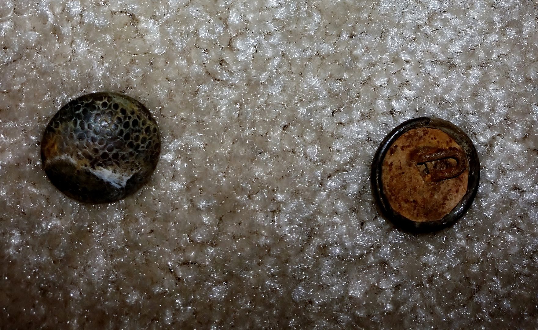
[Edited on 10-30-2021 by David K]
|
|
|
David K
Honored Nomad
Posts: 64493
Registered: 8-30-2002
Location: San Diego County
Member Is Offline
Mood: Have Baja Fever
|
|
Keep the history investigation alive! If I can help with any of my old maps or books, let me know... as sharing old, out-of-print books keeps them
alive!
I still hope one of us can find something more on the Pole Line Road construction in 1942!
|
|
|
David K
Honored Nomad
Posts: 64493
Registered: 8-30-2002
Location: San Diego County
Member Is Offline
Mood: Have Baja Fever
|
|
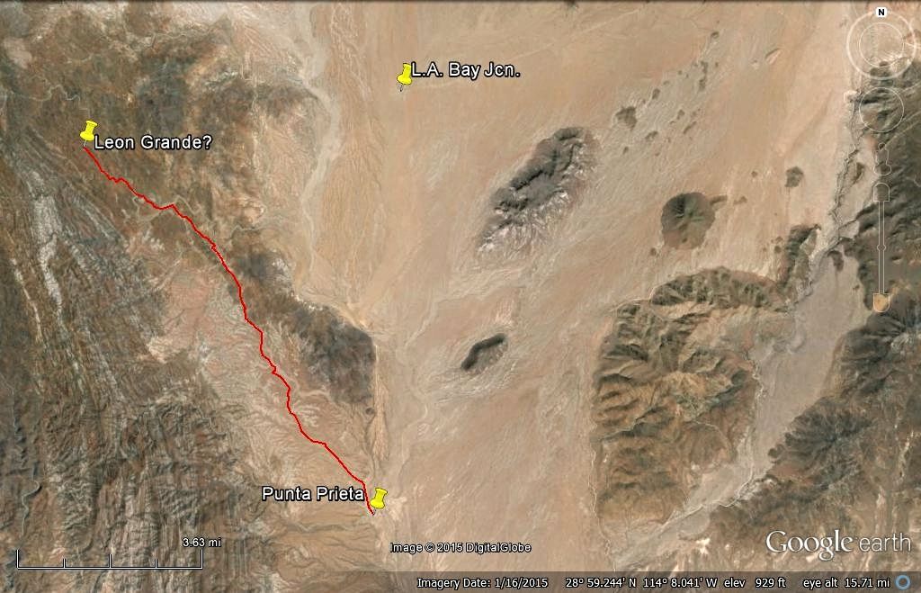
Still seeking Leon Grande photos... anyone?
|
|
|
bajaric
Senior Nomad
Posts: 605
Registered: 2-2-2015
Member Is Offline
|
|
Hi DK,
Looking at the symbol for Leon Grande on the geological map, it seems to be several miles north of where you "triangulated" it. Especially in
relation to the oddly shaped Mesas el Leoncito and the tributary drainage just south of the Mesa. The Mesa looks like a lion with 4 legs upside down
biting how cool is that I wonder if that is why they called it "Big Lion"
A dirt track departs from the BOLA junction (Parador Punta Prieta) northwest, jogs north a short distance on old Hwy 1, then goes west in a straight
line several miles towards the general area just south of where the map shows Leon Grande. This is the northern of the two routes Harald posted,
above. I would guess Leon Grande it is out there somewhere, though not so far east as Harald's "pin".
The road is probably impassable by now, if it was abandoned in the 1920's, but it seems like a great place to explore would be great to see some
photos..
[Edited on 2-12-2021 by bajaric]
|
|
|
David K
Honored Nomad
Posts: 64493
Registered: 8-30-2002
Location: San Diego County
Member Is Offline
Mood: Have Baja Fever
|
|
Leon Grande is on the Geology map... I missed seeing it when I was doing the triangulation... Here it is pointed out, thanks to Harald:
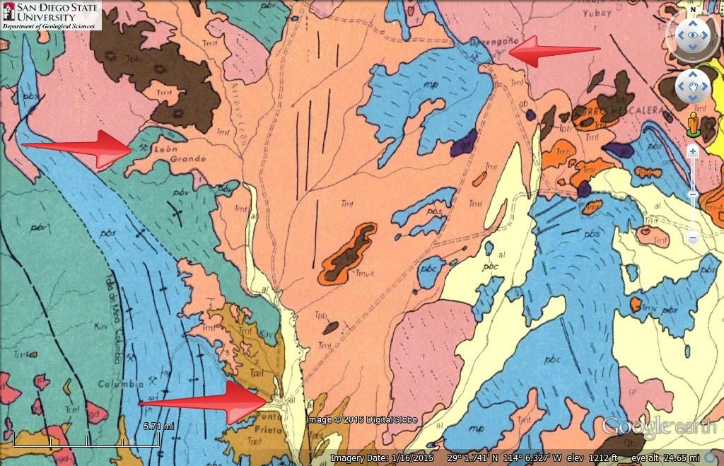
On Google Earth you can see the road going 9 miles to it from Punta Prieta town.
[Edited on 12-5-2021 by David K]
|
|
|
bajaric
Senior Nomad
Posts: 605
Registered: 2-2-2015
Member Is Offline
|
|
I see what you did there, DK. You identified the possible location of where Hale encountered the Mexican road building crew, at their camp site where
there was a spring.
The mine symbol on the geological map is several miles to the north, in a roadless area. Apparently they never finished building the road to the
mine.
Thanks for posting that, I put a description of Leon Grande in my book, Exploring the Gold Districts of Baja California Norte. (Work in progress)
|
|
|
David K
Honored Nomad
Posts: 64493
Registered: 8-30-2002
Location: San Diego County
Member Is Offline
Mood: Have Baja Fever
|
|
Hi Ric,
Exploring Baja for our computers is an easy way when we can't be there, in person.
The road on Google Earth going northwest from beautiful downtown Punta Prieta ends in 10.2 miles at Leon Grande (or a line of 9 miles as the crow
flies).
Leon Grande is also about 5 miles west of the L.A. Bay junction at Hwy. 1 (Parador Punta Prieta)... just a tad south of straight west.
The name comes from the geology map but corresponds with Hale's book for distance.
Is there a reason you believe that the mine symbol and the name Leon Grande at that symbol is in error (on the geology map)?
I don't think I was identifying the road crew location, earlier?
In the book (pages 65-69) it identifies Leon Grande as the place with a spring (page 67), 15 kms (9 mi) north of Punta Prieta and ~15 kms south of
Agua Leon (page 66), a difficult to spot water hole (which they missed seeing).
They mention the road built from L.A. Bay to Punta Prieta (to haul gold ore to ships on) and the road part way done north of Punta Prieta towards Leon
Grande (page 67). The road was to continue several miles to the north of Leon Grande to more gold fields (page 65).
The story is a bit hard to follow as it pops back and forth mentioning the same places.
By looking at the 1918 Goldbaum map (link on VivaBaja.com), you can see the places named in the book: Lake Chapala, Agua Leon, Leon Grande, Punta
Prieta, San Andres, San Miguel, Miller's Landing, Calmallí...
Even on the 1930 map, we see Laguna Seca (Chapala), Agua Leon, Leon Grande, Punta Prieta... and lots of mine symbols and oro mentioned!>>>

[Edited on 3-15-2021 by David K]
|
|
|
David K
Honored Nomad
Posts: 64493
Registered: 8-30-2002
Location: San Diego County
Member Is Offline
Mood: Have Baja Fever
|
|
Link to the Military Button article (removed by the OP of 6 years ago): https://www.academia.edu/9891437/A_Military_Button_from_Baja...
|
|
|
4x4abc
Ultra Nomad
Posts: 4170
Registered: 4-24-2009
Location: La Paz, BCS
Member Is Offline
Mood: happy - always
|
|
I re-read the research paper
like many other papers I have read, it is very sloppy when it comes to the location
the site is not 7km from El Rosarito - but 7.5 miles
the authors named it Rosarito Site - but it has an established name: Santo Domiguito
Linck called it Agua de Refugio
the Arroyo running through the site is not El Becerro - but Arroyo Santo Dominguito
it has a small little cemetery (not on INEGI)
super cool site

Harald Pietschmann
|
|
|
4x4abc
Ultra Nomad
Posts: 4170
Registered: 4-24-2009
Location: La Paz, BCS
Member Is Offline
Mood: happy - always
|
|
what I found in many years exploring Baja California is that it seems that all humans are drawn to the same spots for rest, camping, settling
like I find a spot that seems comfortable for the night (next to a prominent tree, next to a protective rock face) and I notice an old camp fire.
Hanging out for a while I might even find Indigenes artifacts
some years ago I noticed a spot for the night in Cañada de Enmedio (Pole Line Road). And don't laugh - I often hear voices even though I am all
alone. I feel the presence of people. Even though I am all alone.
So I settle on this spot for the night.
Not only did I find arrow heads - I found US military uniform knobs.
So, not only the soldiers building/traveling the Pole Line Road approved this spot for the night - Indigenes did too.
With that in mind - of course one would find uniform knobs at Santo Dominguito. Aside from the water source, it looks inviting for a camp.

Harald Pietschmann
|
|
|
David K
Honored Nomad
Posts: 64493
Registered: 8-30-2002
Location: San Diego County
Member Is Offline
Mood: Have Baja Fever
|
|
Glad you commented on the article, Harald.
The kilometer distance in that paper may be way off, but the map shows the location correctly, very close to the Santa Rosalillita paved road junction
(Km. 38.5). This is 13.5 kms north of Rosarito (= 8.3 miles).

|
|
|
David K
Honored Nomad
Posts: 64493
Registered: 8-30-2002
Location: San Diego County
Member Is Offline
Mood: Have Baja Fever
|
|
Quote: Originally posted by 4x4abc  | I re-read the research paper
like many other papers I have read, it is very sloppy when it comes to the location
the site is not 7km from El Rosarito - but 7.5 miles
the authors named it Rosarito Site - but it has an established name: Santo Domiguito
Linck called it Agua de Refugio
the Arroyo running through the site is not El Becerro - but Arroyo Santo Dominguito
it has a small little cemetery (not on INEGI)
super cool site
|
Where are these graves in relation to the highway?
|
|
|
4x4abc
Ultra Nomad
Posts: 4170
Registered: 4-24-2009
Location: La Paz, BCS
Member Is Offline
Mood: happy - always
|
|
28°43'28.53"N, 114° 6'13.68"W
Harald Pietschmann
|
|
|
David K
Honored Nomad
Posts: 64493
Registered: 8-30-2002
Location: San Diego County
Member Is Offline
Mood: Have Baja Fever
|
|
Thanks... If I get back down there, I want to have a look.
The 1956 and 1958, Lower California Guidebook, has this place, 8.5 miles north of Rosarito, named El Buen Paso (cattle ranch on Arroyo Santo
Dominguito).
The 1962 Lower California Guidebook, 8.5 miles north of Rosarito, calls it Agua de Refugio. Small cattle ranch on Arroyo Santo Dominguito..
The guidebook map was also edited with the name change.
None of the early Auto Clubs guides (1951-1962) mention it.
Here is Gulick's 1962 map, close up:

|
|
|
| Pages:
1
2
3 |


